
Acheron Fossae
 View to Acheron Fossae | |
| Coordinates | 37°40′N135°52′W/ 37.67°N 135.87°W |
|---|---|
Acheron Fossaeis a trough in theDiacria quadrangleofMars.Its location is centered at 37.67° north latitude and 135.87° west longitude. It is 718 km long and is named after a classicalalbedofeature at 35°N, 140°W.[1]The trough has seen intensive tectonic activity in the past. Despite its crescent shape similar to the nearby aureole surrounding Olympus Mons, it is unrelated to them and predates the aureole which areAmazonianin age while Acheron isHesperianin age.
The term "fossae" is used to indicate large troughs when using geographical terminology related to Mars. Troughs, sometimes also calledgrabens,form when the crust is stretched until it breaks, which forms two breaks with a middle section moving down, leaving steep cliffs along the sides. Sometimes, a line of pits form as materials collapse into a void that forms from the stretching.[2]
-
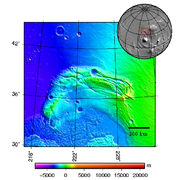 Topography map of Acheron Fossae
 -
 Acheron Fossae Dissected Crater, as seen byHiRISE.Part of eroded floor is shown in image.
 -
 Acheron Fossae, as seen byHiRISE.Scale bar is 1000 meters long. Click on image to see dark slope streaks.
 -
![One theory is dark sand flowed down the slopes of Acheron Fossae. However, they lighten in color over time.[3]](https://upload.wikimedia.org/wikipedia/commons/thumb/4/4b/Slope_Streaks_in_Acheron_Fossae_on_Mars.jpg/240px-Slope_Streaks_in_Acheron_Fossae_on_Mars.jpg) One theory is dark sand flowed down the slopes of Acheron Fossae. However, they lighten in color over time.[3]
One theory is dark sand flowed down the slopes of Acheron Fossae. However, they lighten in color over time.[3] -
 Channel in Acheron Fossae, as seen by HiRISE under HiWish program
 -
 Channels, as seen by HiRISE under HiWish program


![One theory is dark sand flowed down the slopes of Acheron Fossae. However, they lighten in color over time.[3]](/translate/en.wikipedia.org?u=https%3A%2F%2Fen.wikipedia.org%2Fwiki%2FFile%3ASlope_Streaks_in_Acheron_Fossae_on_Mars.jpg&t=hv)


See also
[edit]References
[edit]- ^"Gazetteer of Planetary Nomenclature".Astrogeology Research Program.United States Geological Survey.Retrieved20 March2022.
- ^Mars Global Surveyor MOC2-620 Release
- ^Nemiroff, R.; Bonnell, J., eds. (1 March 2010)."Slope Streaks in Acheron Fossae on Mars".Astronomy Picture of the Day.NASA.
This article about the planet Mars or its moons is astub.You can help Wikipedia byexpanding it. |