
Adige
| Adige | |
|---|---|
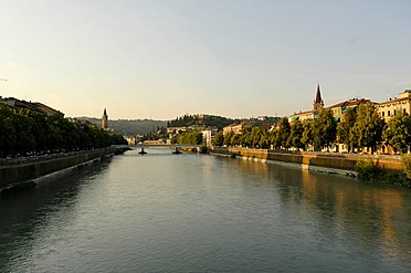
 The Adige inVerona | |
 Map of the Adige River | |
| Etymology | LatinAthesis,from Celtic *yt-ese,"the water" |
| Native name | |
| Location | |
| Country | Italy |
| Physical characteristics | |
| Source | Reschen Pass |
| • location | Graun im Vinschgau,South Tyrol,Italy |
| • coordinates | 46°50′04″N10°30′53″E/ 46.83444°N 10.51472°E |
| • elevation | 1,520 m (4,990 ft) |
| Mouth | Adriatic Sea |
• location | Italy |
• coordinates | 45°8′59″N12°19′13″E/ 45.14972°N 12.32028°E |
• elevation | 0 m (0 ft) |
| Length | 410 km (250 mi) |
| Basin size | 12,100 km2(4,700 sq mi) |
| Discharge | |
| • average | 235 m3/s (8,300 cu ft/s) |
TheAdige(Italian:[ˈaːdidʒe];German:Etsch[ɛtʃ];Venetian:Àdexe[ˈadeze];Romansh:Adisch[ɐˈdiːʃ];Ladin:Adesc;Latin:Athesis;Ancient Greek:Ἄθεσις,romanized:Áthesis,orἌταγις,Átagis[1]) is thesecond-longest riverinItaly,after thePo.It rises near theReschen Passin theVinschgauin the province ofSouth Tyrol,near the Italian border withAustriaandSwitzerland,and flows 410 kilometres (250 mi) through most of northeastern Italy to theAdriatic Sea.
The name of the river is of unknown origin.[2]Nineteenth-century theories, such as a derivation from theProto-Celtic*yt-ese'the water', and alleged to be cognate with theRiver Teesin England (ancientlyAthesis,Teesa),[3]have never been accepted by Celtic onomasts and are now completely obsolete.
Description[edit]
The river source is near theReschen Pass(1,504 metres (4,934 ft)) close to the borders with Austria and Switzerland above theInnValley. It flows through the artificial alpineLake Reschen.The lake is known for the church tower that marks the site of the former village ofAlt Graun( "Old Graun" ); it was evacuated and flooded in 1953 after the dam was finished. NearGlurns,theRomRiver joins from the SwissVal Müstair.
The Adige runs eastward through theVinschgautoMerano,where it is met by thePasserriver from the north. The section between Merano andBolzanois calledEtschtal,meaning Adige Valley. South of Bolzano, the river is joined by theEisackand turns south through a valley which has always been one of the major routes through the Alps, connecting theReschenand theBrennerpasses, at 1,370 metres (4,490 ft) considered the easiest of the main Alpine passes.
TheChiusa di Salornonarrows atSalornoand marks the southernmost part of the predominantly German-speaking province of South Tyrol. The Adige was mentioned in the "Lied der Deutschen"of 1841 as the southern border of the Germanlanguage area.As of 2011 62% of Salorno speaks Italian and 37% speaks German.[4]In 1922 Germany adopted the song as its national anthem, although by that time Italy had taken control of all of the Adige.
NearTrento,theAvisio,Noce, and Fersina rivers join. The Adige crossesTrentinoand laterVeneto,flowing past the town ofRovereto,theLagarina Valley,the cities ofVeronaandRovigoand the north-eastern part of the Po Plain into theAdriatic Sea.The Adige and the Po run parallel in theriver deltawithout properly joining.
The Adige is connected toLake Gardaby theMori–Torbole tunnel,an artificial underground canal built for flood prevention.
Tributaries[edit]
The following rivers are tributaries to the Adige River (from source to mouth):
- Left:Karlinbach,Punibach,Schnalser Bach,Passer,Eisack,Avisio,Fersina,Leno,Alpone
- Right:Rambach,Suldenbach,Plima,Falschauer,Noce
Ecology[edit]
Fauna[edit]

The Adige is a home to themarble trout(Salmo marmoratus), but at far lower populations than in the past. Fish stocking is one of the most significant causes of the sharp reduction in the original (indigenous) fish population of this subspecies. It will spawn with and interbreed withbrown trout,which are regularly stocked in the river and its tributaries.[5]
Gallery[edit]
-
 The true source of the Adige inside abunkerof theAlpine Wall
 -
 The false source
 -

-
 The Adige betweenLaasand Göflan in the Vinschgau
 -
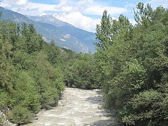
 The Adige flowing throughLagarina Valley
 -
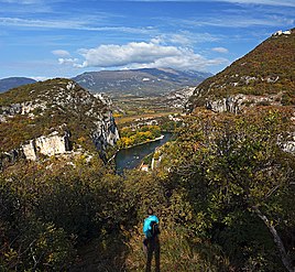 Adige canyon at Chiusa
 -
 The Adige flowing throughVerona
 -
 The Adige flowing through Verona, as seen from theCastelvecchio Bridge
 -
 The Adige flowing through Verona
 -
 The Adige flowing through Verona seen from Castel San Pietro
 -
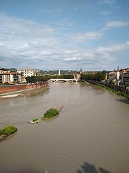
 Adige River andPonte Pietrain Verona
 -
 The mouth of the Adige atRosolinaMare


See also[edit]
- Leno,one of the main tributaries of the Adige River
References[edit]
- ^"Athesis, Athesis".Numen - The Latin Lexicon - An Online Latin Dictionary - A Dictionary of the Latin Language.
- ^Pellegrini, Giovan (2008).Toponomastica italica.Milano: Hoepli. p. 136.
- ^Local Etymology: A Derivative Dictionary of Geographical Names.Houlston and Wright. 22 May 2019 – via Google Books.
- ^"Linguistic census province of Bolzano 2011"(PDF).2011.
- ^Karel Kovar"Hydrology, Water Resources and Ecology in Headwaters".p. 505
External links[edit]
- Encyclopædia Britannica
- Coolidge, William Augustus Brevoort(1911)..Encyclopædia Britannica.Vol. 1 (11th ed.). p. 192.
| International | |
|---|---|
| National | |
| Geographic | |