
Al Jufra Airbase
Al Jufra Airbase  Al Jufra Airbase | |||||||||||
|---|---|---|---|---|---|---|---|---|---|---|---|
| Summary | |||||||||||
| Airport type | Military | ||||||||||
| Operator | Libyan Air Force | ||||||||||
| Serves | Waddan, Libya | ||||||||||
| ElevationAMSL | 846 ft / 258 m | ||||||||||
| Coordinates | 29°11′53″N16°00′04″E/ 29.19806°N 16.00111°E | ||||||||||
| Map | |||||||||||
 Al Jufra Location of the airport in Libya | |||||||||||
| Runways | |||||||||||
| |||||||||||
Al Jufra Airbase(ICAO:HL69) is aLibyan Air Forcebase in Waddan, 9 kilometres (5.6 mi) northeast ofHun,a desert city in theJufra DistrictofLibya.It was originally used by the Libyan Arab Air Force during theGaddafi-erafrom 1969 to 2011.
The runway length does not include 198 metres (650 ft) paved overruns on each end.
The Honnon-directional beacon(Ident:HON) is located 4.7 nautical miles (8.7 km) southwest of the airport.[3]
History
[edit]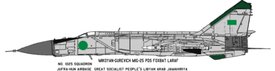
Prior to theFirst Libyan Civil War,during the 1980s, the No. 1025 Squadron operatedMig-25PDsat the Al Jufra-Hun Airbase for defense of the north coast.TU-22,G.222,andAn-26were based at Jufra, parked on open pavement, sand berm shielded pads, and in aircraft shelters.[4]Considering the positioning of many of the aircraft visible in the satellite imagery, and what is known of the maintenance record of theLibyan Air Force,the operational inventory of combat aircraft based at Jufra in 2011 can be assumed to be quite low. The G.222 is believed to have not flown for more than a decade.
No-Fly Zone enforcement
[edit]The airbase was bombed on 24 March 2011 by French aircraft, in accordance with the UN-backed enforcement of the No-Fly Zone over Libya.[5]Over two and a half months later, on 13 June, the area was again struck by NATO forces.[6]
See also
[edit]References
[edit]- ^Airport information for Al Jufra Airportat Great Circle Mapper.
- ^"al Jufrah Airbase".Google Maps.Google.Retrieved17 September2018.
- ^"Hon NDB".Our Airports.Retrieved17 September2018.
- ^Al Jufra- Google Maps
- ^Libyan Air Force[dead link]Forbes
- ^Strike on Libyan airbaseIrish Times
External links
[edit]29°11′53″N16°00′04″E/ 29.198056°N 16.001111°E
This article about an airport in Libya is astub.You can help Wikipedia byexpanding it. |