
Alban Way
| Alban Way | |
|---|---|
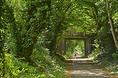
 Cyclists on the Alban Way in May 2017 | |
| Length | 6.3 mi (10.1 km) |
| Location | Hertfordshire,England |
| Trailheads | Hatfield-St Albans |
| Use | Hiking,Cycling,Horseriding |
TheAlban Wayis ashared-use pathalong the formerHatfield and St Albans RailwayinHertfordshire,England.The route is 6.3 miles (10.1 km) long and is owned bySt Albans City & District CouncilandWelwyn Hatfield Borough Council,within their respective boundaries.
History
[edit]The Hatfield and St Albans Railway opened in 1865 and was in use for passengers until 1951 and freight trains until 1969.
Route
[edit]The path runs fromSt Albans,close toSt Albans Abbey railway stationand the site of RomanVerulamium,through Fleetville and Smallford toHatfield;it ends close toHatfield railway station.
Part ofNational Cycle NetworkRoute 61, which runs from theRiver ThamesatMaidenheadto theRiver LeainWare,the Alban Way is fully tarmacked throughout making it usable all year round. It can be linked to a separate section of Route 61, also along a disused railway route, runs fromWelwyn Garden Cityto Hertford and is called theCole Green Way.
The remains of most of the station platforms still exist along the route, with many as of 2017 having recently been refurbished along with signage and street names painted into the tarmac. A station building still stands at the London Road exit in St Albans, which has been converted into a nursery, while atNast Hyde Halta replicasemaphore signalhas been erected along with a garden and other signage.
At what used to beHill End Station,a small remembrance park has been created to remember a former mental health hospital that existed at the site.[1]It is located in what was the hospital's graveyard, once close to the track opposite Longacres park. Most of the graves are covered and few remain intact but include a plaque describing the story behind the gravestones, including some details about specific patients.
Within the section that runs through Welwyn Hatfield, three smaller stations were on route before Hatfield: Nast Hyde Halt, Lemsford Road Halt and Fiddlebridge. Part of the route in the 1980s was cut through by the A1(M) and Hatfield Tunnel and passes close to The Galleria.
In Hatfield, the route joins theGreat North Way(National Cycle Network route 12) and, in St Albans, links to National Cycle Network route 6.
Future proposals
[edit]There was once some speculation that the railway may be reinstated in the future as an extension to the proposedAbbey Linetram system[2]although this never materialised.
Bus connections
[edit][Red Eagle] route S4 provides a link to the start of the route by Cottonmill Lane. Passengers should alight at Weyman's to join the route. Bus service 601 by Uno also runs close to part of the route from Fleetville to Hatfield.
Gallery
[edit]These May 2017 photographs are ordered from the Hatfield end towards the St Albans end.
-
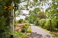 Remains of Nast Hyde Halt railway station
 -
 Nast Hyde Halt railway station platform
 -
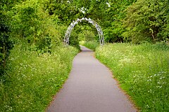 Sculptural arch on the Alban Way
 -
 Hill End Lane bridge
 -
 Bridge over Camp Road
 -
 Midland Railway bridge


See also
[edit]References
[edit]- ^"The Cemetery, Hill End Hospital, St Albans, 20th Century".
- ^"St Albans Abbey tram-train announced".Railway Gazette. 30 October 2009. Archived fromthe originalon 4 January 2010.Retrieved4 June2010.
External links
[edit] Media related toAlban Wayat Wikimedia Commons