Amsterdam–Rhine Canal
Appearance
(Redirected fromAmsterdam-Rhine Canal)
You can helpexpand this article with text translated fromthe corresponding articlein Dutch.(May 2024)Click [show] for important translation instructions.
|
52°9′8″N5°0′23″E/ 52.15222°N 5.00639°E
| Amsterdam–Rhine Canal | |
|---|---|
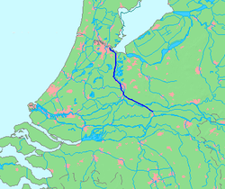
 Map of the Amsterdam–Rhine Canal | |
| Specifications | |
| Length | 72 km (45 mi) |
| History | |
| Date completed | 1952 |
| Geography | |
| Start point | Amsterdam,Netherlands |
| End point | Waalriver nearTiel,Netherlands |
TheAmsterdam–Rhine Canal(Dutch:Amsterdam-Rijnkanaal) is acanalin theNetherlandsthat was built to connect theportand capital city ofAmsterdamto the main shipping artery of theRhine.Its course follows a generally southeasterly direction as it goes through the city ofUtrechttowardsWijk bij Duurstedewhere it intersects theLekbranch of the Rhine and then continues on to the riverWaalnearTiel,with a branch, theLek Canal,to the Lek nearNieuwegein.[1][2] The Amsterdam-Rhine Canal is the world's most frequented artificial waterway with an annual average of 100,000 ships.[3][better source needed]
References[edit]
- ^"Amsterdam-Rhine Canal".Encyclopedia Britannica.Retrieved2022-08-30.
- ^"Amsterdam-Rijnkanaal".Rijkswaterstaat(in Dutch).Retrieved2022-08-30.
- ^"Amsterdam-Rhine canal most busiest canal in the world".Rijkswaterstaat on Twitter(in Dutch).Retrieved2023-02-08.
