
Anaijambad
Anaijambad | |
|---|---|
Village | |
 Anaijambad Location in West Bengal, India  Anaijambad Anaijambad (India) | |
| Coordinates:23°16′43″N86°26′33″E/ 23.2787°N 86.4424°E | |
| Country | |
| State | West Bengal |
| District | Purulia |
| Languages | |
| • Official | Bengali,English |
| Time zone | UTC+5:30(IST) |
| PIN | 723148 |
| ISO 3166 code | IN-WB |
Anaijambad(also referred to as Anai, Mahadeb Berya) is a village, situated nearPuruliatown, in thePurulia IICD blockin thePurulia Sadar subdivisionof thePurulia districtin theIndianstateofWest Bengal.
History
[edit]Purulia had the largest concentration of Jain temples in the western part of Bengal, during 10th-13th century. While many of them crumbled with time, a few survived the ravages of nature - as for example, the temples atPakbirra,Deulghata,DeuliaandBanda[1]
Geography
[edit]
5miles
Hills
M: municipality, CT: census town, R: rural/ urban centre, H: historical/ religious centre, F: facility
Owing to space constraints in the small map, the actual locations in a larger map may vary slightly
Location
[edit]Anaijambad is located at23°16′43″N86°26′33″E/ 23.2787°N 86.4424°E.
Area overview
[edit]Purulia district forms the lowest step of theChota Nagpur Plateau.The general scenario is undulating land with scattered hills.Purulia Sadar subdivisioncovers the central portion of the district. 83.80% of the population of the subdivision lives in rural areas. The map alongside shows some urbanization aroundPuruliacity. 18.58% of the population, the highest among the subdivisions of the district, lives in urban areas. There are 4 census towns in the subdivision. TheKangsabati(locally called Kansai) flows through the subdivision. The subdivision has old temples, some of them belonging to the 11th century or earlier. The focus is on education - the university, the sainik school, the Ramakrishna Mission Vidyapith atBongabari,the upcoming medical college atHatuara,et al.[2][3][4][5][6][7][8][9]
Note: The map alongside presents some of the notable locations in the subdivision. All places marked in the map are linked in the larger full screen map.
Demographics
[edit]According to the2011 Census of India,Anai had a total population of 1,032, of which 542 (53%) were males and 490 (47%) were females. There were 121 persons in the age range of 0-6 years. The total number of literate persons in Anai was 601 (65.97% of the population over 6 years).[10]
Education
[edit]Anai Jambad PSDJ Junior High School is a Bengali-medium coeducational institution established in 1973. It has arrangements for teaching from class V to class X.[11]
Culture
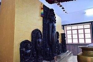
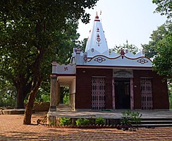
[edit]The Digambar Jain temple at Anaijambad was established in 1973. It houses six statues of four tirthankaras. “The statues are housed within the simple looking temple and are fixed upon an elevated platform”. These were collected from different villages. The Kharkhari Sarak community of neighbouringDhanbadtook the initiative to build the temple.[1]
The statues in the picture below are as follows from left to right:[1]
1. Rishabhanatha (1st Tirthankara)
2. Chandraprabha (8th Tirthankara)
3. Parshavanatha (23 rd Tirthankara)
4. Parshavanatha (23 rd Tirthankara)
5. Kunthunatha (17th Tirthankars)
6. Chandraprabha (8th Tirthankara)
Anaijambad picture gallery
[edit]-
 Statues of Tirthankars
 -
 Jain rituals
 -
 The Digambar Jain temple


References
[edit]- ^abc"Jain Temple, Mahadeb Berya, Purulia".Rangan Dutta.Retrieved29 January2020.
- ^Houlton, Sir John,Bihar, the Heart of India,1949, p. 170, Orient Longmans Ltd.
- ^"District Statistical Handbook 2014 Purulia".Tables 2.1, 2.2.Department of Planning and Statistics, Government of West Bengal. Archived fromthe originalon 21 January 2019.Retrieved12 January2020.
- ^"District Census Handbook, Puruliya, Series 20, Part XII A"(PDF).Deulghat - Pages 99-100: Brief Description of Places of Religious, Historical or Archaeological Importance and Places of Tourist Importance of the District.Directorate of Census Operations, West Bengal.Retrieved21 January2020.
- ^"District Census Handbook, Puruliya, Series 20, Part XII A"(PDF).Charra - Page 103: Brief Description of Places of Religious, Historical or Archaeological Importance and Places of Tourist Importance of the District.Directorate of Census Operations, West Bengal.Retrieved21 January2020.
- ^"Sidho-Kano-Birsha University".SKBU.Retrieved17 January2020.
- ^"Sainik School Purulia".SSP.Retrieved1 February2020.
- ^"West Bengal's RKM college bags highest NAAC grade".The Times of India, 16 December 2019.Retrieved31 January2020.
- ^"Purulia Government Medical College & Hospital".PGMCH. Archived fromthe originalon 26 October 2020.Retrieved17 January2020.
- ^"C.D. Block Wise Primary Census Abstract Data(PCA)".West Bengal – District-wise CD Blocks.Registrar General and Census Commissioner, India.Retrieved29 January2020.
- ^"Anai Jambad P.S.D.J. Jr. High School".ICBSE.Retrieved29 January2020.
