
Andul rajbari
This articleneeds additional citations forverification.(October 2021) |
| Andul Rajbari | |
|---|---|
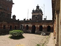
 Frontfaçadeof Andul Royal Palace | |
 | |
| General information | |
| Location | Andul |
| Coordinates | 22°35′00″N88°14′08″E/ 22.5832°N 88.2356°E |
| Completed | 1834 |
TheAndul Rajbariis a palace orrajbarinearKolkatainAndul,Howrah district,West Bengal,India. The rajbari is now a heritage site of Andul.
Geography
[edit]Andul(Bengali: আন্দুল; IAST: Āndula) is a census town in theSankrailblock under the Sadar sub-division inHowrah districtin the Indian state ofWest Bengal.It is a local hub of commercial and industrial activity within and around Sankrail block. It is considered[by whom?]as one of the developing towns in the district and located near toKolkatacity.
History
[edit]| Part ofa serieson |
| Zamindars of Bengal |
|---|
 |
Raja Rajnarayan Bahadur built the palace in 1834 and it was made by the Granville Macleod Company. The family now owns a cinema hall and a local market as well.[1]
Andul Raj picture gallery
[edit]-
 Andul Royal Palace
 -
 Andul Rajbari
 -
 Annapurna & Fourteen Shiva Temples Complex, Andul Royal Palace


References
[edit]- ^"Andul Rajbari and Annapurna Temple".Tripoto.Retrieved17 July2021.
This article about a location in theHowrah districtofWest Bengalis astub.You can help Wikipedia byexpanding it. |