Arden, New York
This articlerelies largely or entirely on asingle source.(January 2022) |
Arden, New York | |
|---|---|
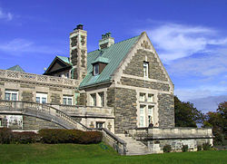
 Wing of the home on the Arden estate in 2003 | |
| Coordinates:41°16′N74°9′W/ 41.267°N 74.150°W | |
| Country | United States |
| State | New York |
| County | Orange |
| Elevation | 210 ft (64 m) |
| Time zone | UTC-5(Eastern (EST)) |
| • Summer (DST) | UTC-4(EDT) |
| ZIP code | 10910 |
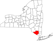
Ardenis ahamletaround the town line of theOrange Countytowns ofTuxedoandMonroein the "boot" ofNew York,United States, west of theHudson River.It is roughly coterminous with the 10910ZIP Code.
The area was originally known as Greenwood, and was noted for theiron worksbelonging to Robert and Peter P. Parrott, ofParrott gunfame. The Greenwood Furnace was established in 1810; during theAmerican Civil War,the furnace produced the iron for the famous Parrott Gun, which was built inCold Springby the Parrott brothers. The Parrotts builtSt. John's Episcopal Churchin Arden in 1863. By the 1890s, the iron industry in New York was in decline due to the discovery of surface beds of iron inMinnesota.
The hamlet takes its current name from theArdenestate built in the area by railroad magnateEdward H. Harrimanin the late 19th century. It is today aNational Historic Landmark,but not open to the public. TheOpen Space Instituteacquired the building and 540 surrounding acres fromColumbia Universityfor $4.5 million in 2007. In 2011, the Open Space Institute sold the Arden Estate property to another nonprofit organization for $4.5 million.[1]
See also
[edit]References
[edit]- ^Rosen, Daniel Edward (November 2, 2011)."$4.5 million".Observer.com.
Sources
[edit]- Myles, William J.,Harriman Trails, A Guide and History,The New York-New Jersey Trail Conference, New York, N.Y., 1999.


