
Area code 661
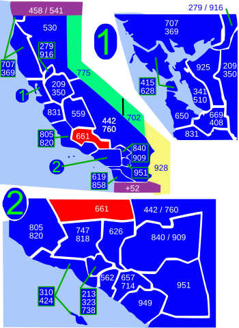
Area code 661is a telephonearea codein theNorth American Numbering Planfor the southern part of theSan Joaquin Valleyand for the far northern part of theLos Angeles metropolitan area.The numbering plan area comprises most ofKern County,most of northernLos Angeles County(specifically theSanta Clarita Valley,theAntelope Valleyand the surrounding mountains), and small parts ofVentura County,Santa Barbara County,andTulare County.It was created in anarea code splitofarea code 805on February 13, 1999.
Principal cities in the numbering plan area areBakersfield,Lancaster,Palmdale,andSanta Clarita.
Service area[edit]
Kern County[edit]
- Arvin
- Bakersfield
- Bear Valley Springs
- Buttonwillow
- Caliente
- Delano
- Edwards Air Force Base
- Famoso
- Fellows
- Frazier Park
- Golden Hills
- Grapevine
- Havilah
- Keene
- Lake of the Woods
- Lamont
- Lebec
- Lost Hills
- Maricopa
- McFarland
- McKittrick
- Mettler
- Mojave
- North Edwards
- Oildale
- Pine Mountain Club
- Rosamond
- Rosedale
- Shafter
- South Taft
- Stallion Springs
- Taft
- Taft Heights
- Tehachapi
- Tupman
- Valley Acres
- Walker Basin
- Wasco
- Weedpatch
- Wheeler Ridge
Los Angeles County[edit]
Santa Barbara County[edit]
Tulare County[edit]
See also[edit]
References[edit]
External links[edit]
| North:559 | ||
| West:805/820 | 661 | East:442/760 |
| South:805/820,747/818,626 |