
Bang Rak district
Bang Rak
บางรัก | |
|---|---|
 Skyline of Bang Rak, from across theChao Phraya River | |
 Location in Bangkok | |
| Coordinates (district office):13°43′50″N100°31′25″E/ 13.73056°N 100.52361°E | |
| Country | Thailand |
| Province | Bangkok |
| Seat | Si Phraya |
| Khwaeng | 5 |
| Area | |
| • Total | 5.54 km2(2.14 sq mi) |
| Population (2019)[1] | |
| • Total | 48,227 |
| • Density | 8,700/km2(23,000/sq mi) |
| Postal code | 10500 |
| Geocode | 1004 |
| Website | www |
Bang Rak(Thai:บางรัก,pronounced[bāːŋrák]) is one of thefifty districts(khet) ofBangkok,Thailand.It lies on the eastern bank of theChao Phraya River,beyondKhlong Phadung Krung Kasem,which marked the old city boundary. Originating from riverside settlements dating from before the city's foundation, Bang Rak grew inland as new roads and canals were constructed through the area during the second half of the nineteenth century and the early twentieth, attracting communities of expatriates and developing into a major commercial district.
Bangkok's rapid economic growth in the late twentieth century saw the areas alongSi LomandSathonroads transformed into one of the city's main business districts, teeming with skyscrapers. The district, officially recognised at least since 1908, covers an area of 5.54 square kilometres (2.14 sq mi), and has a registered population of 48,227 (as of 2019).
History
[edit]Up until the mid-nineteenth century, water formed the primary mode of transport in the lower Chao Phraya plains, and most people lived along the banks of rivers and canals. Settlements had formed along theChao Phraya Riversince theAyutthaya Kingdom(14th century – 1767), and some Buddhist temples in and around Bang Rak date to the period.Bangkok became the capital citywith the foundation of theThonburi Kingdomin 1767, and was re-established as theRattanakosin Kingdomin 1782; riverside areas beyond the fortified city ofRattanakosin Islanddeveloped into fringe neighbourhoods settled by various ethnic communities. Downstream of the city and just beyond theChinatownarea, the waterfront stretch that is nowBang Rak Subdistrictwas home to Thais, Chinese, Vietnamese, Malays, Lao,Tavoyans,anddescendants of Portuguese,among others. A Catholic church (now in the adjacentTalat Noineighbourhood),dedicated to the Lady of the Rosary,was established by the Portuguese community in 1787. French priests then moved into the area for missionary work, followed by Protestants, mostly from the United States.
As international trade increased in the nineteenth century, the neighbourhood developed into one of many port areas along the river.[2]
By the time of KingMongkut's reign (Rama IV, 1851–1868), the city had outgrown itsoriginal defensive walls,and the King ordered the digging ofKhlong Phadung Krung Kasemto serve as a new outer moat surrounding the city proper. The canal separated Bang Rak, on the far side from the city, from the Chinatown area, and as the country began modernizing and opened to the West under Mongkut's reign, European visitors began establishing themselves here. TheBowring Treatywas signed with the British in 1855, liberalizing trade and granting diplomatic concessions, and other Western countries followed suit. Consulates, trading companies and expatriate communities were established in the waterfront area, which became the city's European quarter.[3]

The Westerners also indirectly set off the city's transformation. They petitioned Mongkut to build roads for their use, first to thePhra Khanong area(to where they planned to relocate but later abandoned the idea), then to serve the waterfront community in Bang Rak. The King obliged, and had Thanon Trong (also known as Hua Lamphong Road and later to becomeRama IV Road) constructed in 1857 andCharoen Krung Roadin 1862.Si Lom Roadsoon followed, linking the two. The introduction of land-based transport transformed the city, and Charoen Krung became its main thoroughfare, bringing commerce and spurring development.[3][4]
In the 1890s and 1900s, during the reign of KingChulalongkorn(Rama V, 1868–1910), enterprising businessmen engaged in land development by buying up land and building roads through the area. The resultingSathon,Surawong,andSi Phrayaroads ran roughly parallel to Si Lom, and, together with a few connecting roads between them, have since formed the district's main road network.[5]
The development attracted businesses, which established numerous shops along the roads, as well as newly wealthy residents, who made their homes in villas. Emerging ethnic communities were formed by migrants arriving from Western colonies, who found advantage in the treaties' extraterritorial provisions. Among them were Javanese Muslims, and Hindus, Muslims, and Jains from India, who established places of worship in their neighbourhoods, joining the Christian churches as the missionaries continued to expand their work through the founding of schools and hospitals.[5][6][7]The roads were soon augmented by rail transport, as thePaknam Railway(the country's first line) opened along Thanon Trong in 1893, andelectrified trams began runningon Charoen Krung Road the following year. Another tram line, along Si Lom Road, opened in 1925.[8]

Bang Rak District gradually proceeded to fill up with development, and in the post-World War II period, increasing numbers of foreign businesses moved from the waterfront area into newer premises, especially along Si Lom Road. In 1963, the trams were discontinued, and the canal that ran alongside Si Lom road was filled in for its expansion, further incentivizing its development as a business street.[5](Many of the roads had originally been built with canals running alongside, using the excavated earth. The Paknam Railway was also discontinued, in 1960.) TheDusit Thani Hotel,the city's first high-rise building, opened in 1970, initiating a wave of high-rise construction along Si Lom and Sathon as the economy boomed through the early 1990s.[9]While the1997 financial crisisput an end to the boom, the economy eventually recovered.
The earliest government proclamation naming Bang Rak as a district dates to 1908, and it was re-established with boundaries near its present form in 1915.[10][11]Its status, along with Bangkok's other districts', was later changed fromamphoetokhetin 1972. The district is named Bang Rak after the original waterfront settlement. Whilebangis a common place name prefix for villages situated on a rivers, the origins of the second word are unclear. Early documents variably spelled the name asบางรักorบางรักษ์;the first (and current) spelling fits with the theory that it derived from that of therak(Gluta usitata) tree, a large trunk of which had been found in the area, while the second favours the idea that the name came from the wordrak(รักษ์'heal'), after hospitals operated by the area's missionaries. Today, asrakis also a homonym alternatively meaning "love", the name makes the district office a popular place for marriage registrations, especially on Valentine's Day.[12]
Geography and administration
[edit]Bang Rak District occupies 5.536 square kilometres (2.137 sq mi) in Bangkok's Phra Nakhon side, on the east bank of the Chao Phraya River. It is bordered byPathum Wan districtto the northeast across Rama IV Road,Sathonto the southeast acrossKhlong Sathon(in the middle of Sathon Road),Khlong Santo the west on the other side of the Chao Phraya, andSamphanthawongto the northwest, across Khlong Phadung Krung Kasem.[13]

The district's main thoroughfares, in addition to Rama IV and Sathon roads, which serve as its borders, are Charoen Krung Road, which runs roughly alongside the river, and (from north to south) Si Phraya, Surawong and Si Lom roads, which run in a southwest–northeast direction, roughly parallel to Sathon, linking Rama IV and Charoen Krung. They divide the district into five subdistricts (khwaeng). Bang Rak Subdistrict is on the riverside west of Charoen Krung. East of it, from north to south, areMaha Phruettharam,Si Phraya, Suriyawong, and Si Lom. Together, they have a registered population of 48,227 as of 2019.[1][needs update]
| Name | Area (km2) | Geocode | Population (2019) | ||
|---|---|---|---|---|---|
| 1 | Maha Phruettharam | มหาพฤฒาราม | 0.889 | 100401 | 10,980 |
| 2 | Si Lom | สีลม | 2.074 | 100402 | 18,713 |
| 3 | Suriyawong | สุริยวงศ์ | 0.820 | 100403 | 5,075 |
| 4 | Bang Rak | บางรัก | 0.689 | 100404 | 2,760 |
| 5 | Si Phraya | สี่พระยา | 1.064 | 100405 | 10,699 |
Several streets run between the parallel roads, forming links between them. The only one to cross all of them is Maha Nakhon–Maha Set–Mahesak–Surasak, each section of which is known by a different name as it runs from Rama IV at Maha Nakhon Intersection to meet Sathon Road at Sathon–Surasak Intersection, with the elevatedSi Rat Expresswayrunning nearby. Others include Sap and Naret roads between Si Phraya and Surawong, Decho Road between Surawong and Si Lom, and Sala Daeng, Convent, Pan and Pramuan roads between Si Lom and Sathon. These are relatively small streets, exceptNaradhiwas Rajanagarindra Road,which runs alongsideKhlong Chong Nonsifrom Surawong through Sathon, continuing southeastward towardsRama III RoadinYan Nawa district.On the other side of Bang Rak, Maha Phruettharam Road runs alongside Khlong Phadung Krung Kasem, also linking between Rama IV (at Hua Lamphong Intersection) and Charoen Krung (atPhitthayasathian Bridge).
Neighbourhoods
[edit]
Bang Rak District contains some highly developed areas. Commercial development is most concentrated around Si Lom and Sathon roads, while the areas towards Maha Phruettharam are quieter and mostly residential. Development also fronts Rama IV Road, especially around the neighbourhoods surrounding its intersections:Saphan Lueang(where it is met byBanthat Thong Roadin Pathum Wan District),Sam Yan(where Si Phraya Road meetsPhaya Thai), Henri Dunant (Surawong and Henri Dunant),Sala Daeng(Si Lom andRatchadamri), and Witthayu (Sathon andWitthayu).
The side streets of Si Lom Road form several distinctive neighbourhoods, several of which, like Sala Daeng and Convent, feature restaurants and open spaces nestled behind office towers fronting the main road. Near Si Lom's east end, on the north side (in Suriyawong Subdistrict), several side streets are home to a concentration of nightlife venues. Among them, thePatpongneighbourhood is well known as a red-light district catering to foreigners. On the south side (in Si Lom Subdistrict), near Si Lom–Naradhiwas Intersection,Soi Lalai Sapis a popular office worker's shopping street. Towards the road's Charoen Krung end (Bang Rak Junction), the office towers peter out, and the neighbourhood is marked by the historicTamilIndian presence; the area around Mahesak Road (between Si Lom and Surawong) is also known as a jewellery district.[14][15]

Sathon Road, meanwhile, has a more sterile appearance, with office towers, hotels, and religious, educational and health institutions occupying large blocks along the road. Sathon–Naradhiwas Intersection, near the middle of the road's length, is in particular surrounded by gleaming glass-walled skyscrapers. While establishments line the road on both sides, Bang Rak District only covers those on the north; the road's south side is in the area of Sathon District. The combined Si Lom–Sathon business district generates a large amount of economic activity and employment. Despite being among the country's smallest districts by area, Bang Rak has Bangkok's largest number of jobs, with over 170,000 positions based in the district as of 2016, according to a job-seeking service company.[16]
The flurry of activity, however, doesn't reach the waterfront area along Charoen Krung Road (mostly covered by Bang Rak Subdistrict), which retains much of its historic architecture. While commercially the area had long been eclipsed by newer development, revitalisation efforts since the 2010s have aimed to revive the neighbourhood as a creative district. The area's side streets, such asSoi Charoen Krung 36andCaptain Bush Lane,feature heritage buildings that serve as cultural tourism destinations.[17][18][19][20]
Places
[edit]
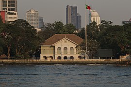
Among the best known features of Bang Rak District are the skyscrapers of Si Lom and Sathon, some of which—Mahanakhon,State Tower,andJewelry Trade Center—are among the tallest buildings in the country. They stand in contrast to colonial-era historic buildings such as theNeilson Hays Libraryand theBritish Clubon Surawong Road, and theSathon Mansionnear Sathon–Naradhiwas Intersection. Other historic buildings are concentrated in the waterfront Charoen Krung area, including the nineteenth-centuryPortugueseandFrenchembassies,Customs House,East Asiatic Building,and original Author's Wing of theMandarin Oriental Hotel.
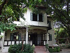
Dating later, from 1940, theGeneral Post Officebuilding on Charoen Krung Road now houses theThailand Creative & Design Center,a sponsor of the Creative District project. From the same period, theBangkokian Museumand Bang Rak District Local Museum, on a side street of Charoen Krung near Maha Set Road, showcases a middle-class family home of the time and features exhibits about the district's history.[18][21]

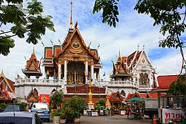
Some of Bang Rak's most noticeable points of interest are places of worship, the diversity of which reflect the area's multicultural history.[19]While the district is home to centuries-old Buddhist temples includingWat Maha Phruettharam(on the same-named road),Wat Hua Lamphong(at Sam Yan Intersection), andWat Suan PhluandWat Muang Khaeon the waterfront, it is the outsize representation of minority religious communities that generate special interest. TheSri Mahamariamman Templeon the corner of Si Lom and Pan roads is the city's largest Hindu temple, serving the Tamil community, while Soi Phuttha-osot off Maha Set Road is home to twoJain templesand theTamil MuslimBangkok Mosque. Other mosques include the Javanese Masjid Mirasuddeen on Soi Si Lom 20, and theBan OouandHaroonmosques, which anchor their historic communities in the riverside area.[6][22]
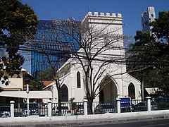
The influence of the Christian missionaries is clearly observable in Bang Rak, not least from their churches—theAssumption Cathedralnear the river is the seat of theRoman Catholic Archdiocese of Bangkok,while over a dozen Protestant churches are located in the district—but also through the schools and hospitals they founded. The Catholic Church operatesAssumption College,Assumption ConventandAssumption Suksaschools, all near the cathedral, as well asSaint Joseph Convent School,situated off Si Lom on Convent Road, opposite the Carmelite Monastery.
Also on Convent Road, on its corner with Sathon, is the historicChrist Church Bangkok,today a parish church of theAnglican Church in Thailand.The country's main Protestant denomination, theChurch of Christ in Thailand,operatesBangkok Christian College,the country's oldest school, which sits on the corner of Sathon and Pramuan roads, as well as theBangkok Christian Hospitalon Si Lom. Other hospitals also have histories related to the Western presence:Lerdsin Hospital(on Si Lom Road, near Bang Rak Intersection) was first headed byThomas Heyward Hays,a doctor with the Presbyterian mission,[23]whileBNH Hospitalwas founded as a nursing home by the British community. The other hospital in the district is Mahaesak Hospital, and other secondary schools include the state-runMahapruttaram Girls' Schooland Buddhajak Wittaya School.[24][25]
Transport
[edit]
Bang Rak is served by theSilom Lineof theBTS Skytrainand theBlue Lineof theMRT,as well as theChao Phraya Express Boatand regularbus services.The Si Rat Expressway has ramps at Rama IV and Si Lom/Sathon roads.
The MRT runs under Rama IV Road along the district's northern border, withHua Lamphong,Sam Yan,Si Lom(at Sala Daeng Intersection), andLumphini(at Witthayu) stations serving the respective neighbourhoods. The Si Lom MRT Station has a link to the BTS'sSala Daeng Station,from where the elevated railway runs along Si Lom Road before turning into Naradhiwas Rajanagarindra, whereChong Nonsi Stationis. It continues onto Sathon Road, serving theSaint Louis,Surasak,andSaphan Taksinstations. The last sits onTaksin Bridge,a major road link across the river, and provides a connection to the express boat'sSathorn Pier.Other piers for the boat service are Oriental, Wat Muang Kae, andSi Phraya.
Gallery
[edit]-
-

-

-
-
-
-
 General Post Officebuilding, headquarters of theTCDC
 -
 Songkran Festivalon Si Lom Road
 -
 Si Lom–Naradhiwas Intersection
 -
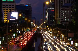 Rush-hour traffic on Sathon Road. (Bang Rak district is shown on the left side.)
 -
 Street Art in Charoen Krung Soi 32


References
[edit]- ^ab"จำนวนประชากร".Official Statistics Registration Systems.Department of Provincial Administration, Ministry of Internal Affairs.Retrieved16 January2021.
- ^Putimahtama, Poom (May–August 2015)."จีนย่านตลาดน้อย: ศรัทธาและเศรษฐกิจการค้าแห่งจีนสยาม"[Chinese Community of Talad Noi: Faiths and Trade of Chinese in Siam].Veridian e-Journal Humanities, Social Sciences and Arts(in Thai).8(2). Silpakorn University: 2590–606.ISSN1906-3431.
- ^abTanabe, Shigeharu (July 1977)."Historical Geography of the Canal System in the Chao Phraya River Delta"(PDF).Journal of the Siam Society.65(2): 23–72.
- ^""ความเรื่องมาก" ของฝรั่งกับการสร้างถนนในสมัยรัชกาลที่ 4 ".Silpa Wattanatham(in Thai). 25 October 2020.Retrieved16 January2021.
- ^abc"นอกพระนครด้านทิศใต้ ย่านจัดสรรที่ดินรุ่นแรกและชุมชนนานาชาติ".มูลนิธิเล็ก-ประไพ วิริยะพันธุ์ Facebook page(in Thai). Lek-Prapai Viriyahpant Foundation. 9 November 2019. Archived fromthe originalon 2022-02-26.Retrieved16 January2021.
- ^abศตนันทน์ สุทิฏฐานุคติ (27 January 2020)."แขกไปใครมา: สืบร่องรอยชาวอินเดียในไทยบนถนนสีลม-เจริญกรุง".The Cloud(in Thai).Retrieved16 January2021.
- ^วรรณ์ฐิตา พวงจันทร์แดง (25 February 2014)."เส้นทางสายศรัทธาที่บางรัก".Sarakadee Magazine(in Thai).Retrieved16 January2021.
- ^"Bangkok Tram Routes".2Bangkok.com.20 October 2002.Retrieved16 January2021.
- ^Rujivacharakul, Vimalin (2004). "Bangkok, Thailand". In Sennott, R. Stephen (ed.).Encyclopedia of Twentieth Century Architecture: Volume 1: A–F.New York: Fitzroy Dearborn. pp. 104–107.ISBN9781579584337.
- ^"ประกาศกระทรวงนครบาล รวมอำเภอชั้นใน"(PDF).Royal Gazette(in Thai).25:312. 14 June 1908. Archived fromthe original(PDF)on January 21, 2021.Retrieved16 January2021.
- ^"ประกาศยกเลิกอำเภอชั้นใน ๗ อำเภอ และตั้งอำเภอชั้นในขึ้นใหม่ ๒๕ อำเภอ"(PDF).Royal Gazette(in Thai).32:335. 31 October 1915. Archived fromthe original(PDF)on November 8, 2011.Retrieved16 January2021.
- ^"ถ้าคำว่ารัก ใน" บางรัก "ไม่เกี่ยวกับ" ความรัก "แล้วชื่อย่านบางรัก มาจากไหน?".ศิลปวัฒนธรรม(in Thai). Silpa Wattanatham. 2 September 2020.Retrieved13 January2021.
- ^"ข้อมูลทั่วไป".สำนักงานเขตบางรัก.Bang Rak District Office. Archived fromthe originalon 11 February 2020.Retrieved13 January2021.
- ^Luekens, David (23 March 2017)."Bangkok's two Little Indias".Travelfish.Retrieved18 January2021.
- ^Scott, Allen J. (2015).The Cultural Economy of Cities: Essays on the Geography of Image-Producing Industries.SAGE Publications Ltd.ISBN978-1446236178.
- ^"จ๊อบไทยเผย 5 เขตที่มีงานหนาแน่นที่สุด".Than Settakij(in Thai). 22 March 2016.Retrieved18 January2021.
- ^Pajai, Wanpen (12 October 2020)."New ideas meet rich heritage on Bangkok's Charoenkrung Road".Southeast Asia Globe.Retrieved13 January2021.
- ^abSvasti, Pichaya (22 March 2018)."Discovering how Bangkok blossomed".Bangkok Post.Retrieved26 June2018.
- ^abKarnjanatawe, Karnjana (16 May 2019)."Bring yourself to Bang Rak".Bangkok Post.Retrieved3 February2021.
- ^อังคณา นาคเกิด (9 November 2017)."Hidden Gem in Old Town: หลงเสน่ห์เมืองเก่าเพราะ" ที่นี่…บางรัก "".Urban Creature(in Thai).
- ^อลิษา ลิ้มไพบูลย์ (6 February 2019)."Go West!: 10 เรื่องเล่าจากร่องรอยโลกตะวันตกในย่านเจริญกรุง".The Cloud(in Thai).Retrieved13 January2021.
- ^อลิษา ลิ้มไพบูลย์ (29 May 2018)."ศิลปะอิสลามแห่งเจริญกรุง: ลายแทงศิลปะอิสลามในมัสยิดและอาคารเก่าย่านเจริญกรุง".The Cloud(in Thai).Retrieved19 January2021.
- ^สมศักดิ์ ลีเชวงวงศ์, ed. (June 2019).สถาปนาครบรอบ 70 ปี โรงพยาบาลเลิดสิน กรมการแพทย์ กระทรวงสาธารณสุข(PDF)(in Thai). Lerdsin General Hospital, Department of Medical Services. pp. 14–21.ISBN9789744228932.
- ^"โรงพยาบาล".สำนักงานเขตบางรัก(in Thai). Bang Rak District Office.Retrieved20 January2021.
- ^"สถานศึกษา และศาสนสถาน".สำนักงานเขตบางรัก(in Thai). Bang Rak District Office.Retrieved20 January2021.
- Bunruecha, Sattrawut (8 November 2017)."People Left Behind in Bangkok's Flourishing Neighborhoods".Khaosod English.Retrieved13 November2017.
Further reading
[edit]- Van Roy, Edward (2017).Siamese Melting Pot: Ethnic Minorities in the Making of Bangkok.ISEAS-Yusof Ishak Institute.ISBN9789814762830.
External links
[edit] Mediafrom Commons
 Travel informationfrom Wikivoyage
- Bang Rak District Office website((in Thai))
Places adjacent to Bang Rak district | |
|---|---|
