
Bartolomé Island
This articleneeds additional citations forverification.(February 2024) |
 Bartolomé Island | |
| Geography | |
|---|---|
| Location | Galápagos Islands,Ecuador |
| Coordinates | 0°17′06″S90°32′56″W/ 0.285°S 90.549°W |
| Archipelago | Galápagos Islands |
| Administration | |
Bartolomé Island(Spanish:Isla Bartolomé) is a volcanic islet in theGalápagos Islandsgroup,[1]just off the east coast ofSantiago Island.It is one of the "younger" islands in theGalápagosarchipelago. This island, and Sulivan Bay on Santiago island, are named after naturalist and lifelong friend of Charles Darwin,Sir Bartholomew James Sulivan,who was a lieutenant aboardHMSBeagle.[2]
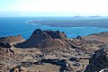
The islet has a total land area of 1.2 square kilometres (0.5 square miles), and consists of an extinct volcano and a variety of red, orange, green, and glistening black volcanic formations. A planked 114-metre hiking trail leads up the side of Bartolomé's volcanic cone. The summit provides views across the water to other islands in the archipelago.
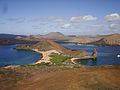
Bartolomé is famous for itsPinnacle Rock,a distinctive volcanic plug that juts out over Sullivan Bay. One of two bays divided by a narrow isthmus, Sullivan Bay is known as a snorkelling spot, where visitors may swim withpenguins,marineturtles,white-tipped reef sharks, and other tropical fish.Galápagos penguinsare frequently seen, and a small cave behind Pinnacle Rock houses a breeding colony. Seasonally, Bartolomé is the mating and nesting site forgreen turtles,which – along withherons– make use of the gentler beaches. The endemic Galápagoslava cacticolonise the lava fields here.
Gallery[edit]
-
 Spatter cone
 -
 Pinnacle RockOverlook
 -

-
 View from Bartolomé Island
 -
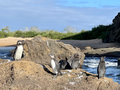 Galápagos Penguins on Bartolomé Island
 -
 Lava Cactus on the Island
 -
 Small Orange Lighthouse at the Summit of Bartolomé Island


References[edit]
- ^"Bartolomé".Galapagos Conservancy.galapagos.org.Retrieved6 June2017.
- ^"Bartolome Island Tour".galapagosalternative.com.Retrieved6 June2017.