Baudh State
Appearance
| Baudh State | |||||||
|---|---|---|---|---|---|---|---|
| Princely StateofBritish India | |||||||
| 14th century–1948 | |||||||
|
Flag | |||||||
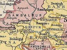
 Baudh State in theImperial Gazetteer of India | |||||||
| Area | |||||||
• 1921 | 3,274 km2(1,264 sq mi) | ||||||
| Population | |||||||
• 1921 | 130,103 | ||||||
| History | |||||||
• Established | 14th century | ||||||
| 1948 | |||||||
| |||||||
Baudh State,also known asBoudh State,was one of theprincely statesofIndiaduring theBritish Raj.It was recognized as a state in 1874 and had its capital inBoudhtown. Its last ruler signed the document of accession to the Indian Union on 1 January 1948.
History[edit]
According to traditions, after the fall of theSomavamshi dynastyto Eastern Gangas, local chieftains were installed in the region as feudatories. A childless Brahmin chieftain adopted the nephew of the neighbouring Raja of Keonjhar who belonged to theBhanj dynasty.This prince styled himself Ananga Deva and founded the state in the 14th century.[1]
See also[edit]
References[edit]
- ^ODISHA DISTRICT GAZETTEERS BOUDH(PDF),GAD, Govt of Odisha, 1991, p. 23

