
San Francisco Bay Area
San Francisco Bay Area | |
|---|---|
 Location of the Bay Area withinCalifornia. The nine-county Bay Area. Additional counties in the larger thirteen-countycombined statistical area. | |
| Country | United States |
| State | California |
| Subregions | |
| Counties | |
| Core cities | San Jose San Francisco Oakland |
| Other municipalities | |
| Area | |
| • Nine-county | 6,966 sq mi (18,040 km2) |
| • San Jose-San Francisco-Oakland (CSA) | 10,191 sq mi (26,390 km2) |
| Highest elevation | 4,360 ft (1,330 m) |
| Lowest elevation | −13 ft (−4 m) |
| Population (2020) | |
| • Density | 1,100/sq mi (430/km2) |
| • Nine-county | 7.76 million[4] |
| • San Jose-San Francisco-Oakland (CSA) | 9.71 million[4] |
| GDP | |
| • Nine-county | $1.132 trillion (2022) |
| • San Jose-San Francisco-Oakland (CSA) | $1.383 trillion (2022) |
| Time zone | UTC−08:00(Pacific) |
| • Summer (DST) | UTC−07:00(PDT) |
| Area codes | 408/669,415/628,510/341,650,707,925[7] |
| Website | bayareametro |


TheSan Francisco Bay Area,commonly known as theBay Area,is aregion of Californiasurrounding and including theSan Francisco Bay.[8]TheAssociation of Bay Area Governmentsdefines the Bay Area as including the nine counties that border theestuariesofSan Francisco Bay,San Pablo Bay,andSuisun Bay:Alameda,Contra Costa,Marin,Napa,San Mateo,Santa Clara,Solano,Sonoma,andSan Francisco.Other definitions may be either smaller or larger, and may include neighboring counties which are not officially part of the San Francisco Bay Area, such as theCentral Coastcounties ofSanta Cruz,San Benito,andMonterey,or theCentral Valleycounties ofSan Joaquin,Merced,andStanislaus.[9]The Bay Area is known for its natural beauty, prominent universities, technology companies, and affluence. The Bay Area contains many cities, towns, airports, and associated regional, state, and national parks, connected by a complexmultimodal transportationnetwork.
The earliestarchaeological evidenceof human settlements in the Bay Area dates back to 8000–10,000 BC. Theoral traditionof theOhloneandMiwokpeople suggests they have been living in the Bay Area for several hundreds if not thousands of years.[10][11]The Spanish empire claimed the area beginning in the early period ofSpanish colonization of the Americas.Theearliest Spanish exploration of the Bay Areatook place in 1769. The Mexican government controlled the area from 1821 until the 1848Treaty of Guadalupe Hidalgo.Also in 1848,James W. Marshalldiscovered gold innearby mountains,resulting in explosive immigration to the area and theprecipitous decline of the Native population.TheCalifornia Gold Rushbrought rapid growth to San Francisco.[12]California wasadmitted as the 31st statein 1850. Amajor earthquake and fireleveled much of San Francisco in 1906. DuringWorld War II,the Bay Area played a major role in America's war effort in theAsiatic-Pacific Theater,with theSan Francisco Port of Embarkation,of whichFort Masonwas one of 14 installations and location of the headquarters, acting as a primary embarkation point for American forces. Since then, the Bay Area has experienced numerous political, cultural, and artistic movements, developing unique local genres in music and art and establishing itself as a hotbed ofprogressive politics.Economically, the post-war Bay Area saw large growth in the financial and technology industries, creating an economy with agross domestic productof over $700 billion. In 2018 it was home to the third-highest concentration ofFortune 500companies in the United States.[13][14]
The Bay Area is home to approximately 7.52 million people.[15]The larger federal classification, thecombined statistical areaof the region which includes 13 counties,[9]is the second-largest inCalifornia—after theGreater Los Angelesarea—and the fifth-largest in the United States, with over 9 million people.[16]The Bay Area's population is ethnically diverse: roughly three-fifths of the region's residents areHispanic/Latino,Asian,African/Black,Indian,orPacific Islander,all of whom have a significant presence throughout the region. Most of the remaining two-fifths of the population isnon-Hispanic White American.The most populous cities of the Bay Area areOakland,San Francisco,andSan Jose,the latter of which in 2022 had population of 971,233, making it the12th-most populous in the United States.[17][18]
Despite its urban character, the San Francisco Bay is one of California's most ecologically sensitive habitats, providing importantecosystem servicessuch as filtering the pollutants and sediments from rivers and supporting a number ofendangered species.In addition, the Bay Area is known for its stands ofcoast redwoods,many of which are protected in state and county parks. The region is additionally known for the complexity of its landforms, the result of millions of years oftectonic platemovements. Because the Bay Area is crossed by 6 majorearthquake faults,the region is particularly exposed to hazards presented by large earthquakes. The climate is temperate and conducive to outdoor recreational and athletic activities such as hiking, running, and cycling. The Bay Area is host tosix professional sports teamsand is a cultural center for music, theater, and the arts. It is also host tonumeroushigher education institutions, includingresearch universitiessuch as theUniversity of California, Berkeley,andStanford University,the latter known for helping to create the high tech center calledSilicon Valley.Home to 101 municipalities and 9 counties, governance in the Bay Area involves numerous local and regional jurisdictions, often with broad and overlapping responsibilities.
History
[edit]
The Coyote Hills Shell Mound, the earliest known archaeological evidence of human habitation of the Bay Area estuaries, dates to around 10,000 BCE, with evidence pointing to even earlier settlement inPoint ReyesinMarin County.[19]It has been conjectured that the people living in the Bay Area at the time of first European contact were descended fromSiberiantribes who arrived at around 1,000 BCE by sailing over theArctic Oceanand following the salmon migration.[20]However the current academic consensus is compatible with theoral traditionof theOhloneandMiwokpeoples, which suggests they have been living in the Bay Area for several hundreds if not thousands of years.[10][11]
At the time of colonization, the Ohlone peoples in the Bay Area primarily lived on the San Francisco Peninsula, in the South Bay and in the East Bay, and the Miwok primarily lived in the North Bay, northern East Bay, and Central Valley.Ohlone villageswere spread across the Peninsula, East Bay, South Bay, as well as further south into theMonterey Bayarea.[21]There were eight major divisions of Ohlone people, four of which were based in the Bay Area: theKarkinof theCarquinez Strait,theChochenyoof theEast Bay,theRamaytushof theSan Francisco Peninsula,and theTamienof the South Bay. TheMiwokhad two major groups in the Bay Area: theBay MiwokofContra Costaand theCoast MiwokofMarinandSonoma.
In 1542,Juan Rodríguez Cabrilloexplored the Pacific coast near the Bay Area though the expedition did not see theGolden Gateor the estuaries, likely due to fog.Sir Francis Drakebecame the first European to land in the area and claim it in June 1579, when he landed atDrakes Baynear Point Reyes. Even though he claimed the region forQueen Elizabeth IasNova AlbionorNew Albion,the English made no immediate follow up to the claim.[22][23][24]
In 1595,Philip II of SpaintaskedSebastião Rodrigues Soromenhowith mapping the west coast of the Americas. Soromenho set sail onManila GalleonSan Agustinon July 5, 1595 and in early November they reached land betweenPoint St. GeorgeandTrinidad Head,north of the Bay Area, in theLost Coast.The expedition followed the coast southward and on November 7 theSan Agustinanchored in Drakes Bay, and claimed the region asPuerto y Bahía de San Francisco.[25][26][27]In late November, a storm sank theSan Agustinand killed between 7 and 12 people. On December 8, 80 remaining crew members set sail on theSan Buenaventura,alaunchwhich was partially constructed en route fromthe Philippines.Seeking the fastest route south, the expedition sailed past the Golden Gate, arriving atPuerto de Chacala, Mexicoon January 17, 1596.[28]


The Bay Area estuaries remained unknown to Europeans until members of thePortolá expedition,while trekking along the California coast, encountered them in 1769 when theGolden Gateblocked their continued journey north.[29]Severalmissionswere founded in the Bay Area during this period. In 1806, a Spanish expedition led byGabriel Moragabegan at the Presidio, traveled south of the bay, and then east to explore theSan Joaquin Valley.[30]
In 1821, Mexicogained its independencefrom Spain and the Bay Area became part of the Mexican province ofAlta California,a period characterized byranch lifeand visiting American trappers.[31]Mexico's control of the territory would be short-lived, however, and in 1846 a party of settlersoccupiedSonoma Plazaand proclaimed the independence of the newRepublic of California.[31]That same year, theMexican–American Warbegan, and American captainJohn Berrien Montgomerysailed theUSSPortsmouthinto the bay and seized San Francisco, which was then known asYerba Buena,and raised theAmerican flagfor the first time overPortsmouth Square.[32]

In 1848,James W. Marshall's discovery of gold in theAmerican Riversparked theCalifornia Gold Rush,and within half a year 4,000 men were panning for gold along the river and finding $50,000 per day.[33]The promise of fabulous riches quickly led to a stampede of wealth-seekers descending onSutter's Mill.The Bay Area's population quickly emptied out as laborers, clerks, waiters, and servants joined the rush to find gold, and California's first newspaper,The Californian,was forced to announce a temporary freeze in new issues due to labor shortages.[33]By the end of 1849, news had spread across the world and newcomers flooded into the Bay Area at a rate of one thousand per week on their way to California's interior,[33]including the first large influx ofChinese immigrants to the U.S.[34]The rush was so great that vessels were abandoned by the hundreds in San Francisco's ports as crews rushed to the goldfields.[35]The unprecedented influx of new arrivals spread the nascent government authorities thin, and the military was unable to prevent desertions. As a result, numerous vigilante groups formed to provide order, but many tasked themselves with forcibly moving or killing localNative Americans,and by the end of the Gold Rush, two thirds of the indigenous population had been killed.[36]

During this same time, aconstitutional conventionwas called to determine California's application forstatehoodinto the United States. After statehood was granted, the capital city moved between three cities in the Bay Area: San Jose (1849–1851),Vallejo(1851–1852), andBenicia(1852–1853) before permanently settling inSacramentoin 1854.[37]As the Gold Rush subsided, wealth generated from the endeavor led to the establishment ofWells Fargo Bankand theBank of California,and immigrant laborers attracted by the promise of wealth transformed the demographic makeup of the region. Construction of theFirst transcontinental railroadfrom theOakland Long Wharfattracted so manylaborers from Chinathat by 1870, eight percent of San Francisco's population was of Asian origin.[38]The completion of the railroad connected the Bay Area with the rest of the United States, established a truly national marketplace for the trade of goods, and accelerated the urbanization of the region.[39]

In the early morning of April 18, 1906,a large earthquakewith an epicenter near the city of San Francisco hit the region.[40]Immediate casualty estimates by theU.S. Army's relief operations were 498 deaths in San Francisco, 64 deaths inSanta Rosa,and 102 in or near San Jose, for a total of about 700. More recent studies estimate the total death count to be over 3,000, with over 28,000 buildings destroyed.[41]Rebuilding efforts began immediately.Amadeo Peter Giannini,owner of theBank of Italy(now known as theBank of America), had managed to retrieve the money from his bank's vaults before fires broke out through the city and was the only bank withliquidfunds readily available and was instrumental in loaning out funds for rebuilding efforts.[42]Congress immediately approved plans for a reservoir inHetch Hetchy ValleyinYosemite National Park,a plan they had denied a few years earlier, which now provides drinking water for 2.4 million people in the Bay Area. By 1915, the city had been sufficiently rebuilt and advertised itself to the world during thePanama Pacific Expositionthat year, although the effects of the quake hastened the loss of the region's dominant status in California to theLos Angeles metropolitan area.[42]
During the1929 stock market crashand subsequenteconomic depression,not a single San Francisco-based bank failed,[43]while the region attempted to spur job growth by simultaneously undertaking two large infrastructure projects: construction of theGolden Gate Bridge,which would connect San Francisco withMarin County,[44]and theBay Bridge,which would connect San Francisco with Oakland and the East Bay.[45]After the United States joinedWorld War IIin 1941, the Bay Area became a major domestic military and naval hub, with large shipyards constructed inSausalitoand across the East Bay to build ships for the war effort.[46]The Army's San Francisco Port of Embarkation was the primary origin for Army forces shipping out to thePacific Theater of Operations.[47][48]That command consisted of fourteen installations including Fort Mason, theOakland Army Base,Camp StonemanandFort McDowellin San Francisco Bay and the sub port of Los Angeles.[49]
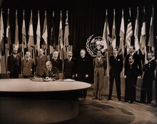
After World War II, theUnited Nationswas chartered in San Francisco, and in September 1951, theTreaty of San Franciscoto re-establish peaceful relations between Japan and theAllied Powerswas signed in San Francisco, entering into force a year later.[50]In the years immediately following the war, the Bay Area saw a huge wave of immigration as populations increased across the region. Between 1950 and 1960, San Francisco welcomed over 100,000 new residents, inland suburbs in the East Bay saw their populations double,Daly City's population quadrupled, andSanta Clara's population quintupled.[46]

By the early 1960s, the Bay Area and the rest ofNorthern Californiabecame the center of thecounterculture movement.Telegraph AvenueinBerkeleyand theHaight-Ashburyneighborhood in San Francisco were seen as centers of activity,[51]with the hit Americanpop songSan Francisco (Be Sure to Wear Flowers in Your Hair)further enticing like-minded individuals to join the movement in the Bay Area and leading to theSummer of Love.[52]In the proceeding decades, the Bay Area would cement itself as a hotbed ofNew Leftactivism,student activism,opposition to the Vietnam Warand otheranti-war movements,theblack power movement,and thegay rights movement.[51]At the same time, parts of San Mateo and Santa Clara counties began to rapidly develop from anagrarianeconomy into a hotbed of thehigh-tech industry.[53]Fred Terman,the director of a top-secret research project atHarvard Universityduring World War II, joined the faculty atStanford Universityin order to reshape the university's engineering department. His students, includingDavid PackardandWilliam Hewlett,would later help usher in the region's high-tech revolution.[46]In 1955,Shockley Semiconductor Laboratoryopened for business in Mountain View near Stanford, and although the business venture was a financial failure, it was the firstsemiconductorcompany in the Bay Area, and the talent that it attracted to the region eventually led to a high-tech cluster of companies later known asSilicon Valley.[54]

In 1989, in the middle of aWorld Seriesgame between two Bay Area baseball teams, theLoma Prieta earthquakestruck and caused widespread infrastructural damage, including the failure of theBay Bridge,a major link between San Francisco andOakland.[55]Even so, the Bay Area's technology industry continued to expand and growth in Silicon Valley accelerated: theUnited States censusconfirmed that year that San Jose had overtaken San Francisco in terms of population.[56]The commercialization of theInternetin the middle of the decade rapidly created aspeculative bubblein the high-tech economy known as thedot-com bubble.This bubble began collapsing in the early 2000s and the industry continued contracting for the next few years, nearly wiping out the market. Companies likeAmazon.comandGooglemanaged to weather the crash however, and following the industry's return to normalcy, their market value increased significantly.[57]
Even as the growth of the technology sector transformed the region's economy,progressive politicscontinued to guide the region's political environment. By the turn of the millennium,non-Hispanic whites,the largest ethnic group in the United States, were only half of the population in the Bay Area as immigration among minority groups accelerated.[58]During this time, the Bay Area was the center of theLGBT rights movement:in 2004, San Francisco began issuingmarriage licenses to same-sex couples,a first in the United States,[59]and four years later a majority of voters in the Bay Area rejected CaliforniaProposition 8,which sought to constitutionally restrict marriage to opposite-sex couples but ultimately passed statewide.[60]

The Bay Area was also the center of contentious protests concerning racial andeconomic inequality.In 2009, anAfrican-Americanman namedOscar Grant was fatally shotbyBay Area Rapid Transit police officers,precipitating widespread protests across the region and even riots in Oakland.[61]His name was symbolically tied to theOccupy Oaklandprotests two years later that sought to fight against social and economic inequality.[62]By August 2023, San Francisco was in such severe decline that MayorMatt Mahanof San Jose joked that one day the region might be renamed the "San Jose Bay Area", after its largest and most prosperous city.[63]
Geography
[edit]Boundaries
[edit]
The borders of the San Francisco Bay Area are not officially delineated, and the unique development patterns influenced by the region'stopography,as well as unusualcommutepatterns caused by the presence of three central cities and employment centers located in various suburban locales, has led to considerable disagreement between local and federal definitions of the area.[64]Because of this, professor ofgeographyat theUniversity of California, BerkeleyRichard Walker claimed that "no other U.S. city-region is as definitionally challenged [as the Bay Area]."[64]
When the region began to rapidly develop during and immediately afterWorld War II,local planners settled on a nine-county definition for the Bay Area, consisting of the counties that directly border theSan Francisco,San Pablo,andSuisunestuaries:Alameda,Contra Costa,Marin,Napa,San Francisco,San Mateo,Santa Clara,Solano,andSonomacounties.[65]Today, this definition is accepted by most local governmental agencies includingSan Francisco Regional Water Quality Control Board,[66]Bay Area Air Quality Management District,[67]theSan Francisco Bay Restoration Authority,[68]theMetropolitan Transportation Commission,[69]and theAssociation of Bay Area Governments,[70]the latter two of which partner to deliver a Bay Area Census using the nine-county definition.[71]
VariousU.S. Federal governmentagencies use definitions that differ from their local counterparts' nine-county definition. For example, theFederal Communications Commission(FCC) which regulates broadcast, cable, and satellite transmissions, includes nearbyColusa,LakeandMendocinocounties in their "San Francisco-Oakland-San Jose"media market,but excludes eastern Solano county.[72]On the other hand, the United StatesOffice of Management and Budget,which designatesmetropolitan statistical areas(MSAs) andcombined statistical areas(CSA) for populated regions across the country, has five MSAs which include, wholly or partially, areas within the nine-county definition, and one CSA which includes eight Bay Area counties (excludingSonoma), but including neighboringSan Benito,Santa Cruz,San Joaquin,Merced,andStanislauscounties.[9]
The Association of Bay Area Health Officers (ABAHO), an organization that has fought local outbreaks ofHIV/AIDSin 1980s and withCOVID-19 pandemicandDeltacronhybrid variant (2020–22), consists of the public health officers of 9 Bay Area counties, in addition to theCentral Coastcounties ofSanta Cruz,San Benito,andMontereyand the city ofBerkeley.
| County | 2022 estimate | 2020–22 change |
2020 Population | 2010 Population | 2010–20 change |
2020 Density (per sq mi) | MSA |
|---|---|---|---|---|---|---|---|
| Alameda | 1,628,997 | -3.2% | 1,682,353 | 1,510,271 | +11.4% | 2,281.3 | San Francisco–Oakland–Berkeley‡ |
| Contra Costa | 1,156,966 | -0.8% | 1,165,927 | 1,049,025 | +11.1% | 1,626.3 | |
| Marin | 256,018 | -2.4% | 262,321 | 252,409 | +3.9% | 504.1 | |
| San Francisco | 808,437 | -7.5% | 873,965 | 805,235 | +8.5% | 18,629.1 | |
| San Mateo | 729,181 | -4.6% | 764,442 | 718,451 | +6.4% | 1,704.0 | |
| San Benito | 67,579 | +5.3% | 64,209 | 55,269 | +16.2% | 46.2 | San Jose–Sunnyvale–Santa Clara |
| Santa Clara | 1,870,945 | -3.4% | 1,936,259 | 1,781,642 | +8.7% | 1,499.7 | |
| Napa | 134,300 | -2.7% | 138,019 | 136,484 | +1.1% | 184.4 | Napa |
| Solano | 448,747 | -1.0% | 453,491 | 413,344 | +9.7% | 551.8 | Vallejo–Fairfield |
| Sonoma† | 482,650 | -1.3% | 488,863 | 483,878 | +1.0% | 310.3 | Santa Rosa–Petaluma |
| Merced | 290,014 | +3.1% | 281,202 | 255,793 | +9.9% | 145.1 | Merced |
| Santa Cruz | 264,370 | -2.4% | 270,861 | 262,382 | +3.2% | 608.5 | Santa Cruz–Watsonville |
| San Joaquin | 793,229 | +1.3% | 779,233 | 685,306 | +13.7% | 559.6 | Stockton–Lodi |
| Stanislaus | 551,275 | -0.3% | 552,878 | 514,453 | +7.5% | 369.6 | Modesto |
| Bay Area counties colored red †Sonoma County was separated from the CSA in 2023.[9] ‡Renamed to San Francisco–Oakland–Fremont in 2023.[9] | |||||||
Subregions
[edit]Among locals, the nine-county Bay Area is divided into five sub-regions: theEast Bay,North Bay,Peninsula,city ofSan Francisco,andSouth Bay.
The "East Bay"is the densest region of the Bay Area outside of San Francisco and includes cities and towns inAlemedaandContra Costacounties centered aroundOakland.As one of the larger subregions, the East Bay includes a variety of enclaves, including the suburbanTri-Valleyarea and the highly urban western part of the subregion that runs alongside the bay, including Oakland.[74]
The "North Bay"includesMarin,Sonoma,Napa,andSolanocounties, and is the largest and least populated subregion. The western counties of Marin and Sonoma are encased by thePacific Oceanon the west and the bay on the east and are characterized by their mountainous and woody terrain. Sonoma and Napa counties are known internationally for their grape vineyards andwineries,and Solano County to the east, centered aroundVallejo,is the fastest growing region in the Bay Area.[75]
- Regions of the Bay Area
-
 East Bay
 -
 South Bay
 -
 North Bay
 -
 San Francisco and the Peninsula


The "Peninsula"subregion includes the cities and towns on the San Francisco Peninsula, excluding the titular city of San Francisco. Its eastern half, which runs alongside the Bay, is highly populated, while its less populated western coast traces the coastline of the Pacific Ocean and is known for its open space and hiking trails. Roughly coinciding with the borders ofSan Mateo County,it also includes the northwesternSanta Clara Countycities ofPalo Alto,Mountain View,andLos Altos.[76]
Although geographically located on the tip of the San Francisco Peninsula, the city ofSan Franciscois not considered part of the "Peninsula" subregion, but as a separate entity.[77][78]
The term "South Bay" has different meanings to different groups: Writing in 1959 for theArmy Corps of Engineers,theUnited States Department of Commercedefined the South Bay as comprising five counties, corresponding to their two-way division of the bay into north and south regions.[79]In 1989, the federalEnvironmental Protection Agencydefined the South Bay as the northern part of Santa Clara County and the southeastern part of San Mateo County.[80]
Climate
[edit]
The Bay Area is located in thewarm-summer Mediterranean climatezone (KöppenCsb) that is a characteristic of California's coast, featuring mild to cool winters with occasional rainfall, and warm to hot, dry summers.[81]It is largely influenced by the coldCalifornia Current,which penetrates the natural mountainous barrier along the coast by traveling through various gaps.[82]In terms ofprecipitation,this means that the Bay Area has pronounced seasons. The winter season, which roughly runs between November and March, is the source of about 82% of annual precipitation in the area. In the South Bay and further inland, while the winter season is cool and mild, the summer season is characterized by warm sunny days,[82]while in San Francisco and areas closer to the Golden Gate strait, the summer season is periodically affected by fog.[83]

Due to the Bay Area's diversetopographic relief(itself the result of the clashingtectonic plates), the region is home to numerousmicroclimatesthat lead to pronounced differences in climate and temperature over short distances.[81][84]Within the city of San Francisco, natural and artificial topographical features direct the movement of wind and fog, resulting in startlingly varied climates between city blocks. Along theGolden Gate Strait,oceanic wind and fog from the Pacific Ocean are able to penetrate the mountain barriers inland into the Bay Area.[84]
During the summer, rising hot air in California's interior valleys creates a low pressure area that draws winds from theNorth Pacific Highthrough the Golden Gate, which creates the city'scharacteristic cool winds and fog.[83]The microclimate phenomenon is most pronounced during this time, when fog penetration is at its maximum in areas near the Golden Gate strait,[84]while the South Bay and areas further inland are sunny and dry.[82]

Along the San Francisco peninsula, gaps in theSanta Cruz Mountains,one south ofSan Bruno Mountainand another in Crystal Springs, allow oceanic weather into the interior, causing a cooling effect for cities along the Peninsula and even as far south as San Jose. This weather pattern is also the source for delays atSan Francisco International Airport.In Marin county north of the Golden Gate strait, two gaps north ofMuir Woodsbring cold air across theMarin Headlands,with the cooling effect reaching as far north asSanta Rosa.[84]Further inland, the East Bay receives oceanic weather that travels through the Golden Gate strait, and further diffuses that air through theBerkeley Hills,Niles Canyonand the Hayward Pass into theLivermore ValleyandAltamont Pass.Here, the resulting breeze is so strong that it is home to one of the world's largest array ofwind turbines.Further north, theCarquinez Straitfunnels the ocean weather into theSan Joaquin River Delta,causing a cooling effect inStocktonandSacramento,so that these cities are also cooler than theirCentral Valleycounterparts in the south.[84]
| City | Jan | Feb | Mar | Apr | May | Jun | Jul | Aug | Sep | Oct | Nov | Dec |
|---|---|---|---|---|---|---|---|---|---|---|---|---|
| Fairfield[85] | 55 / 39 (13 / 4) |
61 / 42 (16 / 6) |
66 / 45 (19 / 7) |
71 / 47 (22 / 8) |
78 / 52 (26 / 11) |
85 / 56 (29 / 13) |
90 / 58 (32 / 14) |
89 / 57 (32 / 14) |
86 / 56 (30 / 13) |
78 / 51 (26 / 11) |
65 / 44 (18 / 7) |
55 / 39 (13 / 4) |
| Oakland[86] | 58 / 44 (14 / 7) |
67 / 47 (19 / 8) |
64 / 49 (18 / 9) |
66 / 50 (19 / 10) |
69 / 53 (21 / 12) |
72 / 55 (22 / 13) |
72 / 56 (22 / 13) |
73 / 58 (23 / 14) |
74 / 57 (23 / 14) |
72 / 54 (22 / 12) |
65 / 49 (18 / 9) |
58 / 45 (14 / 7) |
| San Francisco[87] | 57 / 46 (14 / 8) |
60 / 48 (16 / 9) |
62 / 49 (17 / 9) |
63 / 49 (17 / 9) |
64 / 51 (18 / 11) |
66 / 53 (19 / 12) |
66 / 54 (19 / 12) |
68 / 55 (20 / 13) |
70 / 55 (21 / 13) |
69 / 54 (21 / 12) |
63 / 50 (17 / 10) |
57 / 46 (14 / 8) |
| San Jose[88] | 58 / 42 (14 / 6) |
62 / 45 (17 / 7) |
66 / 47 (19 / 8) |
69 / 49 (21 / 9) |
74 / 52 (23 / 11) |
79 / 56 (26 / 13) |
82 / 58 (28 / 14) |
82 / 58 (28 / 14) |
80 / 57 (27 / 14) |
74 / 53 (23 / 12) |
64 / 46 (18 / 8) |
58 / 42 (14 / 6) |
| Santa Rosa[89] | 59 / 39 (15 / 4) |
63 / 41 (17 / 5) |
67 / 43 (19 / 6) |
70 / 45 (21 / 7) |
75 / 48 (24 / 9) |
80 / 52 (27 / 11) |
82 / 52 (28 / 11) |
83 / 53 (28 / 12) |
83 / 52 (28 / 11) |
78 / 48 (26 / 9) |
67 / 43 (19 / 6) |
59 / 39 (15 / 4) |
Ecology
[edit]
Marine wildlife
[edit]The Bay Area is home to a diverse array ofwildlifeand, along with the connectedSan Joaquin River Deltarepresents one of California's most important ecological habitats.[90]California'sDungeness crab,Pacifichalibut,and the Californiascorpionfishare all significant components of the bay'sfisheries.[91]The bay'ssalt marshesnow represent most of California's remaining salt marsh and support a number of endangeredspeciesand provide key ecosystem services such as filtering pollutants andsedimentsfrom the rivers.[92]Most famously, the bay is a key link in thePacific Flywayand with millions ofshorebirdsannually visiting the bay shallows as a refuge, is the most important component of the flyway south ofAlaska.[93]Manyendangered speciesof birds are also found here: theCalifornia least tern,theCalifornia clapper rail,thesnowy egret,and theblack crowned night heron.[94]

There is also a significant diversity ofsalmonidspresent in the bay.Steelheadpopulations in California have dramatically declined due to human and natural causes; in the Bay Area, all naturally spawnedanadromoussteelhead populations below natural and manmade impassable barriers in California streams from theRussian RivertoAptos Creek,and the drainages of San Francisco, San Pablo, and Suisun Bays are listed as threatened under theFederal Endangered Species Act.[95]The Central California Coastcoho salmonpopulation is the most endangered of the many troubled salmon populations on thewest coast of the United States,including populations residing intributariesto the San Francisco Bay.[96]California CoastChinook salmonwere historically native to theGuadalupe Riverin San Francisco Bay, and Chinook salmon runs persist today in the Guadalupe River,Coyote Creek,Napa River,andWalnut Creek.[97]Industrial, mining, and other uses ofmercuryhave resulted in a widespread distribution of that poisonous metal in the bay, with uptake in the bay'sphytoplanktonand contamination of itssportfish.[98]

Aquatic mammals are also present in the bay. Before 1825, Spanish, French, English, Russians and Americans were drawn to the Bay Area to harvest prodigious quantities ofbeaver,river otter,marten, fisher, mink, fox, weasel, harbor andfur sealsandsea otter.This early fur trade, known as theCalifornia Fur Rush,was more than any other single factor, responsible for opening up the West and the San Francisco Bay Area, in particular, to world trade.[99]By 1817 sea otter in the area were practically eliminated.[100]Since then, theCalifornia golden beaverre-established a presence inAlhambra Creek,followed by the Napa River andSonoma Creekin the north, and the Guadalupe River and Coyote Creek in the south.[101]TheNorth American river otterwhich was first reported inRedwood CreekatMuir Beachin 1996,[102]has since been spotted in the North Bay'sCorte Madera Creek,the South Bay'sCoyote Creek,[103]as well as in 2010 in San Francisco Bay itself at theRichmond Marina.Other mammals include the internationally famoussea lionswho began inhabiting San Francisco'sPier 39after the1989 Loma Prieta earthquake[104]and the locally famousHumphrey the Whale,ahumpback whalewho entered San Francisco Bay twice on errant migrations in the late 1980s and early 1990s.[105]Bottlenose dolphinsandharbor porpoiseshave recently returned to the bay, having been absent for many decades. Historically, this was the northern extent of their warm-water species range.[106]
Birds
[edit]
In addition to the many species of marine birds that can be seen in the Bay Area, many other species of birds make the Bay Area their home, making the region a popular destination forbirdwatching.[107]Many birds are listed asendangered speciesdespite once being common in the region.
Western burrowing owlswere originally listed as aspecies of special concernby theCalifornia Department of Fish and Gamein 1979. California's population declined 60% from the 1980s to the early 1990s, and continues to decline at roughly 8% per year.[108]A 1992–93 survey reported little to no breeding burrowing owls in most of the western counties in the Bay Area, leaving onlyAlameda,Contra Costa,andSolanocounties as remnants of a once large breeding range.[109]

Bald eagleswere once common in the Bay Area, but habitat destruction and thinning of eggs fromDDTpoisoning reduced the California state population to 35 nesting pairs. Bald eagles disappeared from the Bay Area in 1915, and only began returning in recent years.[110]In the 1980s an effort to re-introduce the species to the area began with the Santa Cruz Predatory Bird Research Group and theSan Francisco Zooimporting birds and eggs fromVancouver Islandand northeastern California,[111]and there are now nineteen nesting couples in eight of the Bay Area's nine counties.[110]Other once absent species that have returned to the Bay Area includeSwainson's hawk,white tailed kite,and theosprey.[110]

In 1927,zoologistJoseph Grinnellwrote that osprey were only rare visitors to the San Francisco Bay Area, although he noted records of one or two used nests in the broken tops ofredwoodtrees along theRussian River.[112]In 1989, the southern breeding range of the osprey in the Bay Area wasKent Lake,although osprey were noted to be extending their range further south in the Central Valley and the Sierra Nevada.[113]In 2014, a Bay Area-wide survey found osprey had extended their breeding range southward with nesting sites as far south asHunters Pointin San Francisco on the west side andHaywardon the east side, while further studies have found nesting sites as far south as theLos Gatos Creekwatershed, indicating that the nesting range now includes the entire length of San Francisco Bay.[114]Most nests were built on man-made structures close to areas of human disturbance, likely due to lack of mature trees near the Bay.[115]Thewild turkeypopulation was introduced in the 1960s by state game officials, and by 2015 have become a common sight in East Bay communities.[116]
Geology and landforms
[edit]
The Bay Area is well known for the complexity of its landforms that are the result of the forces ofplate tectonicsacting over of millions of years, since the region is located in the middle of a meeting point between two plates.[117]Nine out of eleven distinctassemblageshave been identified in a single county, Alameda.[118]Diverse assemblages adjoin in complex arrangements due to offsets along the many faults (both active and stable) in the area. As a consequence, many types of rock and soil are found in the region. The oldest rocks aremetamorphic rocksthat are associated with granite in theSalinian Blockwest of theSan Andreas Fault.These were formed fromsedimentaryrocks ofsandstone,limestone,andshalein uplifted seabeds.[119]Volcanic deposits also exist in the Bay Area, left behind by the movement of the San Andreas Fault, whose movement sliced a subduction plate and allowed magma to briefly flow to the surface.[120]
The region has considerable vertical relief in its landscapes that are not in thealluvial plainsleading to the bay or in inland valleys. The topography, and geologic history, of the Bay Area can largely be attributed to the compressive forces between the Pacific Plate and the North American plate.[121]

The three major ridge structures in the Bay Area, part of thePacific Coast Range,are all roughly parallel to the majorfaults.TheSanta Cruz Mountainsalong the San Francisco Peninsula and theMarin Hillsin Marin County follow theSan Andreas fault,TheBerkeley Hills,San Leandro Hillsand their southern ridgeline extension throughMission Peakroughly follow theHayward fault,and theDiablo Range,which includesMount DiabloandMount Hamiltonand runs along theCalaveras fault.[122]
In total, the Bay Area is traversed by seven majorfaultsystems with hundreds of related faults, all of which are stressed by the relative motion between thePacific Plateand theNorth American Plateor by compressive stresses between these plates. The fault systems include theHayward Fault Zone,Concord-Green Valley Fault,Calaveras Fault,Clayton-Marsh Creek-Greenville Fault,Rodgers Creek Fault,and theSan Gregorio Fault.[123]Significant blindthrust faults(faults with near vertical motion and no surface ruptures) are associated with portions of theSanta Cruz Mountainsand the northern reaches of theDiablo RangeandMount Diablo.These "hidden" faults, which are not as well known, pose a significant earthquake hazard.[124]Among the more well-understood faults, as of 2014, scientists estimate a 72% probability of amagnitude6.7 earthquake occurring along either the Hayward, Rogers Creek, or San Andreas fault, with an earthquake more likely to occur in the East Bay's Hayward Fault.[125]Two of the largest earthquakes in recent history were the1906 San Francisco earthquakeand the1989 Loma Prieta earthquake.
Hydrography
[edit]
The Bay Area is home to a complex network of watersheds, marshes, rivers, creeks, reservoirs, and bays that predominantly drain into theSan Francisco Bayand Pacific Ocean. The largest bodies of water in the Bay Area are theSan Francisco,San Pablo,andSuisunestuaries. Major rivers of theNorth Bayinclude theNapa River,thePetaluma River,theGualala River,and theRussian River;the former two drain intoSan Pablo Bay,the latter two into the Pacific Ocean. In the South Bay, theGuadalupe Riverdrains intoSan Francisco BaynearAlviso.[126]There are also several lakes present in the Bay Area, including man-made lakes likeLake Berryessa[127]and natural albeit heavily modified lakes likeLake Merritt.[128]
Prior to the introduction of European agricultural methods, the shores of San Francisco Bay consisted mostly of tidal marshes.[129]Today, the bay has been significantly altered heavily re-engineered to accommodate the needs of water delivery, shipping, agriculture, and urban development, with side effects including the loss of wetlands and the introduction of contaminants andinvasive species.[130]Approximately 85% of those marshes have been lost or destroyed, but about 50 marshes and marsh fragments remain.[129]Huge tracts of the marshes were originally destroyed by farmers for agricultural purposes, then repurposed to serve assalt evaporation pondsto produce salt for food and other purposes.[131]Today, regulations limit the destruction of tidal marshes, and large portions are currently being rehabilitated to their natural state.[129]
Over time,droughtsandwildfireshave increased in frequency and become less seasonal and more year-round, further straining the region'swater security.[132][133][134]
Demographics
[edit]| Census | Pop. | Note | %± |
|---|---|---|---|
| 1860 | 114,074 | — | |
| 1870 | 265,808 | 133.0% | |
| 1880 | 422,128 | 58.8% | |
| 1890 | 547,618 | 29.7% | |
| 1900 | 658,111 | 20.2% | |
| 1910 | 925,708 | 40.7% | |
| 1920 | 1,182,911 | 27.8% | |
| 1930 | 1,578,009 | 33.4% | |
| 1940 | 1,734,308 | 9.9% | |
| 1950 | 2,681,322 | 54.6% | |
| 1960 | 3,638,939 | 35.7% | |
| 1970 | 4,628,199 | 27.2% | |
| 1980 | 5,179,784 | 11.9% | |
| 1990 | 6,023,577 | 16.3% | |
| 2000 | 6,783,760 | 12.6% | |
| 2010 | 7,150,739 | 5.4% | |
| 2020 | 7,765,640 | 8.6% | |
| Note: Nine-County Population Totals[58] | |||

According to the2010 United States Census,the population of the nine-county Bay Area was 7.15 million, with 49.6% male and 50.4% female.[58]Of these, approximately 2.3 million (32%) are foreign born.[135]In 2010 the racial makeup of the nine-county Bay Area was 52.5%White(42.4% werenon-Hispanicand 10.1% wereHispanic), 23.3%Asian,6.7% non-Hispanic Black orAfrican American,0.7%Native AmericanorAlaska Native,0.6%Pacific Islander,5.4% fromtwo or more racesand 10.8% from other races.[136]Hispanic or Latinoresidents of any race formed 23.5% of the population.
The Bay Area cities ofVallejo,Suisun City,Oakland,San Leandro,Fairfield,andRichmondare among the most ethnically diverse cities in the United States.[137]
Non-Hispanic whitesform majorities of the population inMarin,Napa,andSonoma counties.[58]Whites also make up the majority in the eastern regions of theEast Baycentered around theLamorindaandTri-Valleyareas.[58]San Francisco'sNorth Beachdistrict is considered theLittle Italyof the city, and was once home to a significant Italian-American community. San Francisco, Marin County[138]and the Lamorinda area[139]all have substantialJewishcommunities. There is aLittle Russiacommunity in northwestern San Francisco, and there are Russian communities throughout the Bay Area, especially in San Mateo County and Santa Clara County; there are also Eastern European American groups such as Ukrainians and Poles in dozens of thousands to hundreds of thousands especially in San Francisco and in the Peninsula, including recent immigrants and American-born citizens of Eastern European descent. There are dozens of Russian-, Ukrainian-, and Polish-speaking churches in San Francisco, the South Bay, the East Bay, and on the Peninsula.
Like much of the U.S., the Bay Area has a large Irish population and this is reflected in theRichmond Districtarea of San Francisco. San Jose has aLittle Portugal.
TheLatinopopulation is spread throughout the Bay Area, but among the nine counties, the greatest number live in Santa Clara County, while Contra Costa County has seen the highest growth rate.[140]The largest Hispanic or Latino groups were those ofMexican(17.9%),Salvadoran(1.3%),Guatemalan(0.6%),Puerto Rican(0.6%) andNicaraguan(0.5%) ancestry.Mexican Americansmake up the largest share of Hispanic residents in Napa county,[141]while Central Americans make up the largest share in San Francisco, many of whom live in theMission Districtwhich is home to many residents ofSalvadoranandGuatemalandescent.[142]


TheAsian-Americanpopulation in the Bay Area is one of the largest in North America.Asian-Americansmake up the plurality in two major counties in the Bay Area:Santa Clara CountyandAlameda County.[143]The largest Asian-American groups were those ofChinese(7.9%),Filipino(5.1%),Indian(3.3%),Vietnamese(2.5%), andJapanese(0.9%) heritage. Asian Americans also constitute a majority inCupertino,Fremont,Milpitas,Union Cityand significant populations inDublin,Foster City,Hercules,Millbrae,San Ramon,Saratoga,SunnyvaleandSanta Clara.The cities of San Jose andSan Franciscohad the third and fourth most Asian-American residents in the United States.[144]In San Francisco,Chinese Americansconstitute 21.4% of the population and constitute the single largest ethnic group in the city.[145]The Bay Area is home to over 382,950Filipino Americans,one of the largest communities of Filipino people outside of thePhilippineswith the largest proportion of Filipino Americans concentrating themselves withinAmerican Canyon,Daly City,Fairfield,Hercules,South San Francisco,Union CityandVallejo.[146]Santa Clara county, and increasingly the East Bay, house a significantIndian Americancommunity.[147]There are more than 100,000 people ofVietnameseancestry residing withinSan Josecity limits, the largest Vietnamese population of any city proper in the world outside ofVietnam.[148]In addition, there is a sizable community ofKorean Americansin Santa Clara county, where San Jose is located.[149]East Bay cities such asRichmond,San Pablo, and Oakland, and the North Bay city ofSanta Rosa,have plentiful populations ofLaotianandCambodiansin certain neighborhoods.[150]
Pacific Islanderssuch asSamoansandTonganshave the largest presence inEast Palo Alto,where they constitute over 7% of the population.[151]San Bruno also has a large Tongan population and so does San Mateo and South San Francisco, which also have smaller communities of Samoans. The Visitacion Valley has a designated Pacific Islander district and Samoan and Tongans have a presence in Southeast San Francisco and Daly City's Bayshore neighborhood.
TheAfrican-Americanpopulation of San Francisco was formerly substantial, had a thrivingjazzscene and was known as "Harlemof the West. "While black residents formed one-seventh of the city's population in 1970, today they have mostly moved to parts of the East Bay and North Bay, includingAntioch,[152]Fairfieldand out of the Bay Area entirely.[153]The South Park neighborhood ofSanta Rosawas once home to a primarily black community until the 1980s, when many Latino immigrants settled in the area.[154]Other cities with large numbers of African Americans includeVallejo(28%),[155]Richmond(26%),[156]East Palo Alto (17%)[151]and theCDPofMarin City(38%).[157]Suisun City and Vacaville both have African American populations that have accelerated in population since the 2000s. There are also Eritrean, Ethiopian and Nigerian communities.
There is also a significant Middle Eastern and Balkan population. There are 4,000Armeniansin San Francisco, and some in the San Jose area. The San Jose area, especially the Campbell area and some areas off of San Jose's Stevens Creek Blvd contain a Bosnian community. There are several thousand Turks in San Francisco, and a Palestinian population is concentrated in Daly City and San Francisco.
Since the economy of the Bay Area heavily relies on innovation and high-tech skills, a relatively educated population exists in the region. Roughly 87.4% of Bay Area residents have attained a high school degree or higher,[158]while 46% of adults in the Bay Area have earned a post-secondary degree or higher.[159]
| Counties by population and ethnicity | ||||||||
|---|---|---|---|---|---|---|---|---|
| County | Type | Population | White | Other | Asian | African | Native | Hispanic |
| Alameda | County | 1,494,876 | 46.2% | 13.8% | 26.2% | 12.5% | 1.3% | 22.2% |
| Contra Costa | County | 1,037,817 | 63.2% | 12.5% | 14.3% | 9.1% | 0.5% | 23.9% |
| Marin | County | 250,666 | 79.9% | 11.0% | 5.6% | 3.0% | 0.2% | 14.0% |
| Napa | County | 135,377 | 81.3% | 8.9% | 6.8% | 2.0% | 0.3% | 31.5% |
| San Francisco | City and county | 870,887 | 48.5% | 11.3% | 33.3% | 6.1% | 0.9% | 15.1% |
| San Mateo | County | 711,622 | 59.6% | 11.1% | 24.6% | 2.9% | 1.8% | 24.9% |
| Santa Clara | County | 1,762,754 | 50.9% | 13.8% | 31.8% | 2.6% | 0.4% | 26.6% |
| Solano | County | 411,620 | 52.1% | 17.6% | 14.4% | 14.6% | 1.4% | 23.6% |
| Sonoma | County | 478,551 | 81.6% | 11.3% | 4.0% | 1.2% | 1.5% | 24.3% |
| Counties by population and income | |||||
|---|---|---|---|---|---|
| County | Type | Population | Per capita income | Median household income | Median family income |
| Alameda | County | 1,494,876 | $34,937 | $70,821 | $87,012 |
| Contra Costa | County | 1,037,817 | $38,141 | $79,135 | $93,437 |
| Marin | County | 250,666 | $54,605 | $89,605 | $113,826 |
| Napa | County | 135,377 | $35,309 | $68,641 | $79,884 |
| San Francisco | City and county | 870,887 | $46,777 | $72,947 | $87,329 |
| San Mateo | County | 711,622 | $45,346 | $87,633 | $104,370 |
| Santa Clara | County | 1,762,754 | $40,698 | $89,064 | $103,255 |
| Solano | County | 411,620 | $29,367 | $69,914 | $79,316 |
| Sonoma | County | 478,551 | $33,119 | $64,343 | $78,227 |
Affluence
[edit]The Bay Area is the wealthiest region per capita in the United States, due, primarily, to the economic power engines ofSan Jose,San Francisco, andOakland.The Bay Area city ofPleasantonhas the second-highest household income in the country afterNew Canaan, Connecticut.However, discretionary income is very comparable with the rest of the country, primarily because the higher cost of living offsets the increased income.[160]
There are 285,000 millionaires living in the region, the third-highest among the world's metropolitan areas afterNew York CityandTokyoas of 2022.[161] The amount of wealth held by Bay Area residents is about $2.6 trillion, the second-highest in the world after New York City, and just ahead of Tokyo as of 2021.[162]
By 2014, the Bay Area'swealth gapwas considerable: the top ten percent of income-earners took home over eleven times as much as the bottom ten percent,[163]and aBrookings Institutionstudy found theSan Francisco metro area,which excludes four Bay Area counties, to be the third most unequalurban areain the country.[164]Among the wealthy, forty-seven Bay Area residents madeForbesmagazine's 400 richest Americans list, published in 2007.
Crime
[edit]Statistics regarding crime rates in the Bay Area generally fall into two categories:violent crimeandproperty crime.Historically, violent crime has been concentrated in a few cities in the East Bay, namelyOakland,Richmond,Martinez,andAntioch,but alsoEast Palo Altoin the Peninsula,Vallejoin the North Bay, andSan Francisco.[165]Nationally, Oakland's murder rate ranked 18th among cities with over 100,000 residents, and third for violent crimes per capita.[166]According to a 2015Federal Bureau of Investigationreport, Oakland was also the source of the most violent crime in the Bay Area, with 16.9 reported incidents per thousand people. Vallejo came in second, at 8.7 incidents per thousand people, while San Pablo, Antioch, and San Francisco rounded out the top five. East Palo Alto, which used to have the Bay Area's highest murder rate, saw violent crime incidents drop 65% between 2013 and 2014, while Oakland saw violent crime incidents drop 15%.[165]Meanwhile,San Jose,which was one of the safest large cities in the United States in the early 2000s, has seen its violent crime rates trend upwards.[167]Cities with the lowest rate of violent crime include the Peninsula cities ofLos AltosandFoster City,East Bay cities ofSan RamonandDanville,and southern foothill cities ofSaratogaandCupertino.In 2015, 45 Bay Area cities counted zero homicides, the largest of which wasDaly City.[165]
In 2015, Oakland also saw the highest rates of property crime in the Bay Area, at 59.4 incidents per thousand residents, with San Francisco following close behind at 53 incidents per thousand residents. The East Bay citiesPleasant Hill,Berkeley,andSan Leandrorounded out the top five.SaratogaandWindsorsaw the least rates of property crime.[165]Additionally, San Francisco saw the most reports of arson.[166]
Several street gangs operate in the Bay Area, including theSureñosandNorteñosin San Francisco'sMission District.[168]Oakland, which also sees organized gang violence, implementedOperation Ceasefirein 2012 in an effort to reduce the violence,[169]with limited success.
Economy
[edit]
The three principal cities of the Bay Area represent separate employment clusters and are dominated by different but commingled industries. San Francisco is home to the region'stourism,financial industry,and is host to numerous conventions. The East Bay, centered around Oakland, is home to heavy industry,metalworking,oil, and shipping, while San Jose is the heart ofSilicon Valleywhere a major pole of economic activity around thetechnologyindustry resides. Furthermore, the North Bay is a major player in the country'sagricultureand wine industry.[64]In all, the Bay Area is home to the second highest concentration ofFortune 500companies, second only to theNew York metropolitan area,with thirty such companies based throughout the region.[170]

In 2019, the greater fourteen-county statistical area had a GDP of $1.086 trillion, the third-highest amongcombined statistical areas.[171]The smaller nine-county Bay Area had a GDP of $995 billion in the same year, which nonetheless would rank it fifthamong U.S. statesand 17thamong countries.[171]
TheCOVID-19 pandemiccaused an exodus of businesses from the downtown cores of San Francisco, San Jose and Oakland, as remote work became more widespread, especially in the tech industry, and the area's locational relevance declined.[172][173]Some observers have warned that this could lead to an economicdoom loopfor Bay Area cities, particularly San Francisco,[174]while others have argued that these concerns are restricted to the downtown core.[175]Many retailers in Downtown San Francisco and Downtown Oakland have closed since 2020,[176]with some citing complex challenges with visible homelessness and crime in the area.[177]Additionally noted is the Bay Area's steadily decreasing lead in the geographically dispersing high technology field, and its relative geographical isolation from most North American commercial markets.[178][179]

Despite this exodus, Bay Area is still the home tofour of the world's ten largest companies by market capitalization;and several major corporations are still headquartered in the Bay Area, includingGoogle,Facebook,Apple Inc.,Clorox,Hewlett-Packard,Intel,Adobe Inc.,Applied Materials,eBay,Cisco Systems,Symantec,Netflix,Sony Interactive Entertainment,Electronic Arts,andSalesforce;energycompanyPG&E;financial service companyVisa Inc.;apparelretailersGap Inc.,Levi Strauss & Co.,andRoss Stores;aerospaceand defense contractorLockheed Martin;localgrocerSafeway;and biotechnology companiesGenentechandGilead Sciences.[177][180]The largest manufacturers includeTesla Inc.,Lam Research,Bayer,andCoca-Cola.[181]ThePort of Oaklandis the fifth-largestcontainer shipping portin the United States, and Oakland is also a majorrail terminus.[182]In research,NASA'sAmes Research Centerand the federal research facilityLawrence Livermore National Laboratoryare based inMountain ViewandLivermorerespectively. In the North Bay, Napa and Sonoma counties are well known for their wineries, includingFantesca Estate & Winery,Domaine Chandon California,andD'Agostini Winery.[183]

In spite of the San Francisco Bay Area's industries contributing to the aforementioned economic growth, there is a significant level of poverty in the region. Rising housing prices and gentrification in the San Francisco Bay Area are often framed as symptomatic of high-income tech workers moving in to previously low-income, underserved neighborhoods.[184]Two notable policy strategies to prevent eviction due to rising rents include rent control and subsidies such asSection 8and Shelter Plus Care.[185]Moreover, in 2002, then San Francisco Supervisor Gavin Newsom introduced the "Care Not Cash" initiative, diverting funds away from cash handouts (which he argued encouraged drug use) to housing. This proved controversial, with some suggesting his rhetoric criminalized poverty, while others supporting the prioritizing of housing as a solution.[186]

Contrary to historical patterns of low incomes within the inner city, poverty rates in the Bay Area are shifting such that they are increasing more rapidly in suburban areas than in urban areas.[187]It is not yet clear whether the suburbanization of poverty is due to the relocation of poor populations or shifting income levels in the respective regions. However, the mid-2000s housing boom encouraged city dwellers to move into the newly cheap houses in suburbs outside of the city, and these suburban housing developments were then most affected by the 2008 housing bubble burst. As such, people in poverty experience decreased access to transportation due to underdeveloped public transport infrastructure in suburban areas. Suburban poverty is most prevalent among Hispanics and Blacks, and affects native-born people more significantly than foreign-born.[187][188]
As greater proportions of their incomes are spent on rent, many impoverished populations in the San Francisco Bay Area also facefood insecurityand health setbacks.[189][190]
Housing
[edit]
The Bay Area is the most expensive location to live in the United States outside ofManhattan.[191]Strong economic growth has created hundreds of thousands of new jobs, but coupled with severe zoning restrictions on building new housing units,[192]has resulted in anextreme housing shortage.For example, from 2012 to 2017, the San Francisco metropolitan area added 400,000 new jobs, but only 60,000 new housing units.[193]As of 2016, the entire Bay Area had 3.6 M jobs, and 2.6 M housing units, for a ratio of 1.4 jobs per housing unit,[194]significantly above the ratio for the US as a whole, which stands at 1.1 jobs per housing unit. (152M jobs, 136M housing units[195][196])
As of 2017, the average income needed in order to purchase a house in the region was $179,390, while the median price for a house was $895,000 and the average cost of a home in the Bay Area being $440,000 - more than twice the national average, while the average monthly rent is $1,240 - 50 percent more than the national average.[197][198]In 2018, a Bay Area household income of $117,000 was classified as "low income" by theDepartment of Housing and Urban Development.[199]

With high costs of living, many Bay Area residents allocate large amounts of their income towards housing. 20 percent of Bay Area homeowners spend more than half their income on housing, while roughly 25 percent of renters in the Bay Area spend more than half of their incomes on rent.[200]Expending an average of more than $28,000 per year on housing in addition to roughly $13,400 on transportation, Bay Area residents spend around $41,420 per year to live in the region. This combined total of housing and transportation signifies 59 percent of the Bay Area's median household income, conveying the extreme costs of living.[200]

The high rate ofhomelessness in the Bay Areacan be attributed to the high cost of living.[201]No approximate number of homeless people living in the Bay Area can be determined due to the difficulty of tracking homeless residents.[201]However, according to San Francisco's Department of Public Health, the number of homeless people in San Francisco alone is 9,975.[202]Additionally, San Francisco was revealed to have the most unsheltered homeless people in the country.[202]
Because of the high cost of housing, many workers in the Bay Area live far from their place of employment, contributing to one of the highest percentages ofextreme commutersin the United States, or commutes that take over ninety minutes in one direction. For example, about 50,000 people commute from neighboringSan Joaquin Countyinto the nine-county Bay Area daily,[203]and more extremely, some workers commute semimonthly by flying.[204]
Education
[edit]Colleges and universities
[edit]
The Bay Area is home to a large number of colleges and universities. The first institution of higher education in the Bay Area,Santa Clara University,was founded byJesuitsin 1851,[205]who also founded theUniversity of San Franciscoin 1855.[206]San Jose State Universitywas founded in 1857 and is the oldest public college on theWest Coast of the United States.[207]According to theBrookings Institution,45% of residents of the two-county San Jose metro area have a college degree and 43% of residents in the five-county San Francisco metro area have a college degree, the second and fourth-highest ranked metro areas in the country for higher educational attainment.[208]
As of 2024[update],Stanford Universityis the highest ranked university in the Bay Area byU.S. News & World Report,[209]and its business school is ranked No. 1 in the US, Canada, Europe and Asia byBloomberg Businessweek.[210]TheUniversity of California, Berkeleyhas been the highest-ranked public university in the country for the past nineteen years.[citation needed]Additionally,San Jose State UniversityandSonoma State Universitywere ranked 3rd and 12th, respectively, among public colleges in the West Coast byU.S. News & World Reportin 2024.[211]


The city of San Francisco is host to two additionalUniversity of Californiaschools, neither of which conferundergraduatedegrees. TheUniversity of California, San Franciscois entirely dedicated to graduate education in health and biomedical sciences. It is ranked among the top five medical schools in the United States[212]and operates theUCSF Medical Center,which is the highest-ranked hospital in California.[213]TheUniversity of California, College of the Law,founded inCivic Centerin 1878, is the oldest law school in California and claims more judges on the state bench than any other institution.[214]The city is also host to aCalifornia State Universityschool,San Francisco State University.[215]Additional campuses of theCalifornia State Universitysystem in the Bay Area areCal State East BayinHaywardandCal MaritimeinVallejo.
California Community Colleges Systemalso operates a number ofcommunity collegesin the Bay Area. According toCNNMoney,the Bay Area community college with the highest "success" rate isDe Anza CollegeinCupertino,which is also the tenth-highest ranked in the nation. Other relatively well-ranked Bay Area community colleges includeFoothill College,City College of San Francisco,West Valley College,Diablo Valley College,andLas Positas College.[216]
Many scholars have pointed out the overlap of education and the economy within the Bay Area. According to multiple reports, research universities such as Stanford University, University of California - Santa Cruz and University of California - Berkeley, are essential to the culture and economy in the area.[159]These universities also provide public programs for people to learn and enhance skills relevant to the local economies. These opportunities not only provide educational services to the community, but also generate significant amounts of revenue.[159]
Primary and secondary schools
[edit]
Public primary and secondary education in the Bay Area is provided through school districts organized through three structures (elementary school districts, high school districts, or unified school districts) and are governed by an elected board. In addition, many Bay Area counties and the city of San Francisco operate "special service schools" that are geared towards providing education to students with handicaps orspecial needs.[217]
An alternative public educational setting is offered bycharter schools,which may be established with a renewable charter of up to five years by third parties. The mechanism for charter schools in the Bay Area is governed by the California Charter Schools Act of 1992.[218]

According to rankings compiled byU.S. News & World Report,the highest-ranked high school in California is thePacific Collegiate School,located inSanta Cruzand part of the greater Bay Area. Within the traditional nine-county boundaries, the highest ranked high school isKIPP San Jose Collegiatein San Jose. Among the top twenty high schools in California includeLowell High Schoolin San Francisco,Monta Vista High SchoolinCupertino,Lynbrook High Schoolin San Jose, theUniversity Preparatory Academyin San Jose,Mission San Jose High SchoolinFremont,Oakland Charter High Schoolin Oakland,Henry M. Gunn High SchoolinPalo Alto,Gilroy Early College AcademyinGilroy,andSaratoga High SchoolinSaratoga.[219]
Transportation
[edit]
Transportation in the San Francisco Bay Area is reliant on a complex multimodal infrastructure consisting of roads, bridges, highways, rail, tunnels, airports, ferries, and bike and pedestrian paths. The development, maintenance, and operation of these different modes of transportation are overseen by various agencies, including the California Department of Transportation (Caltrans),San Francisco Municipal Transportation Agency,and theMetropolitan Transportation Commission.[220]These and other organizations collectively manage severalinterstate highwaysandstate routes,twosubwaynetworks, threecommuter railagencies, eight trans-bay bridges, transbay ferry service, localbusservice,[221]threeinternational airports(San Francisco,San Jose,andOakland),[222]and an extensive network of roads, tunnels, and paths such as theSan Francisco Bay Trail.[223]
The Bay Area hosts an extensive freeway and highway system that is particularly prone totraffic congestion,with one study byInrixconcluding that the Bay Area's traffic was the fourth worst in the world.[224]There are some city streets in San Francisco where gaps occur in the freeway system, partly the result of theFreeway Revolt,which prevented a freeway-only thoroughfare through San Francisco between theSan Francisco–Oakland Bay Bridge,the western terminus ofInterstate 80,and the southern terminus of the Golden Gate Bridge (U.S. Route 101).[225]Additional damage that occurred in the wake of the 1989Loma Prieta earthquakeresulted in freeway segments being removed instead of being reinforced or rebuilt, leading to the revitalization of neighborhoods such as San Francisco'sEmbarcaderoand Hayes Valley.[226]The greater Bay Area contains the three principal north–south highways in California:Interstate 5,U.S. Route 101,andCalifornia State Route 1.U.S. 101 and State Route 1 directly serve the traditional nine-county region, while Interstate 5 bypasses to the east in San Joaquin County to provide a more directLos Angeles–Sacramentoroute. Additional local highways connect the various subregions of the Bay Area together.[227]

There are over two dozenpublic transitagencies in the Bay Area with overlapping service areas that utilize differentmodes,with designated connection points between the various operators.Bay Area Rapid Transit(BART), aheavy rail/metrosystem, operates in five counties and connects San Francisco and Oakland via theTransbay Tube.Othercommuter railsystems link San Francisco with the Peninsula and San Jose (Caltrain), San Jose with theTri-Valley Areaand San Joaquin County (ACE), and Sonoma with Marin County (SMART).[221]
In addition,Amtrakprovides frequent commuter service between San Jose and the East Bay withSacramento,and long-distance service to other parts of the United States.[228]Muni Metrooperates a hybridstreetcar/subwaysystem within the city of San Francisco, andVTAoperates alight railsystem in Santa Clara County. These rail systems are supplemented by numerous bus agencies and transbayferriessuch asGolden Gate Ferryand theSan Francisco Bay Ferry.Most of these agencies accept theClipper Card,a reloadablecontactless smart card,as a universal electronic payment system.[221]
Government and politics
[edit]
Government in the San Francisco Bay Area consists of multiple actors, including 101 city and nine county governments, a dozen regional agencies, and a large number of single-purposespecial districtssuch asmunicipal utility districtsandtransit districts.[229]Incorporated cities are responsible for providing police service, zoning, issuing building permits, and maintaining public streets among other duties.[230]County governments are responsible for elections and voter registration, vital records, property assessment and records, tax collection, public health, agricultural regulations, and building inspections, among other duties.[231][232]Public education is provided by independent school districts, which may be organized as elementary districts, high school districts, unified school districts combining elementary and high school grades, or community college districts, and are managed by an elected school board.[217]A variety of special districts also exist and provide a single purpose, such as delivering public transit in the case of theBay Area Rapid Transit District,[233]or monitoring air quality levels in the case of theBay Area Air Quality Management District.[67]

Politics in the Bay Area is widely regarded as one of the mostliberalinCaliforniaand in the United States.[234][235]Since the late 1960s, the Bay Area has cemented its role as the most liberal region in California politics, giving greater support for thecenter-leftDemocratic Party's candidates than any other region of the state, even as California trended towards the Democratic Party over time.[236]According to research by thePublic Policy Institute of California,the Bay Area and theNorth Coastcounties ofHumboldtandMendocinowere the most consistently and strongly liberal areas in California.[236]
According to theCalifornia Secretary of State,the Democratic Party holds a voter registration advantage in everycongressional district,State Senate district,State Assembly district,State Board of Equalization district,all nine counties, and all of the 101 incorporated municipalities in the Bay Area. On the other hand, thecenter-rightRepublican Partyholds a voter registration advantage in only one State Assembly sub-district (the portion of the4thinSolano County).[237]According to theCook Partisan Voting Index(CPVI), the Bay Area's districts tend to favor Democratic candidates by roughly 40 to 50 percentage points, considerably above the mean for California and the nation overall.[238]
| County | Population[239] | Registered voters[240] | Democratic[240] | Republican[240] | D–R spread[240] | American Independent[240] |
Green[240] | Libertarian[240] | Peace and Freedom[240] |
Americans Elect[240] |
Other[240] | No party preference[240] |
|---|---|---|---|---|---|---|---|---|---|---|---|---|
| Alameda | 1,494,876 | 87.97% | 60.03% | 10.93% | +49.1% | 2.16% | 0.56% | 0.64% | 0.4% | 0.0% | 0.60% | 24.67% |
| Contra Costa | 1,037,817 | 93.24% | 53.26% | 18.51% | +34.75% | 3.2% | 0.4% | 0.86% | 0.39% | 0.0% | 0.4% | 22.6% |
| Marin | 250,666 | 97.66% | 61.42% | 12.63% | +48.79% | 2.66% | 0.6% | 0.78% | 0.2% | 0.0% | 0.48% | 20.95% |
| Napa | 135,377 | 94.51% | 50.02% | 21.39% | +28.63% | 3.59% | 0.57% | 1.15% | 0.38% | 0.0% | 0.68% | 21.78% |
| San Francisco | 870,887 | 78.56% | 62.67% | 6.74% | +55.94 | 1.71% | 0.54% | 0.58% | 0.34% | 0.0% | 0.3% | 25.92% |
| San Mateo | 711,622 | 88.59% | 55.54% | 14.12% | +41.42% | 2.43% | 0.39% | 0.72% | 0.31% | 0.0% | 0.58% | 25.34% |
| Santa Clara | 1,762,754 | 85.68% | 50.44% | 16.64% | +33.81% | 2.41% | 0.36% | 0.81% | 0.39% | 0.0% | 0.29% | 28.63% |
| Solano | 411,620 | 89.5% | 48.59% | 22.09% | +26.5% | 3.56% | 0.39% | 1.04% | 0.5% | 0.0% | 0.62% | 22.88% |
| Sonoma | 478,551 | 91.4% | 56.56% | 17.57% | +38.99% | 3.08% | 0.73% | 1.11% | 0.35% | 0.0% | 0.52% | 19.4% |

InU.S. Presidential electionssince 1960, the nine-county Bay Area voted forRepublicancandidates only two times, in both cases voting for a Californian: in1972forRichard Nixonand again in1980forRonald Reagan.The last county to vote for a Republican presidential candidate wasNapa countyin 1988 forGeorge H. W. Bush.Since then, all nine Bay Area counties have voted consistently for the Democratic candidate.[241]Currently, both of California'sU.S. Senatorsare Democrats, and all twelveU.S. congressional districtslocated wholly or partially in the Bay Area are represented by a Democratic representative. Additionally, every Bay Area member of theCalifornia State Senateand theCalifornia State Assemblyis a registered Democrat.
The Bay Area's association with progressive politics has led to the term "San Francisco values"being used byconservativecommentators in a pejorative sense to describe the secular progressive culture in the area.[242]
Regional governance
[edit]TheAssociation of Bay Area Governments(ABAG) is the principalmetropolitan planning organizationfor the Bay Area. TheMetropolitan Transportation Commission(MTC) is the region's transportation planning agency, which has functionally merged with ABAG through staff consolidation. ABAG and MTC developedPlan Bay Area,which is the area'sregional transportation plan,in 2013 and with its goal date for 2040.
Other regional governance agencies include theBay Area Air Quality Management District,Bay Area Toll Authority,Bay Restoration Authority,and theBay Conservation & Development Commission.
Culture
[edit]Arts
[edit]
The Bay Area was a hub of theAbstract Expressionismmovement of painting. It is associated with the works ofClyfford Still,who began teaching at theCalifornia School of Fine Arts(now theSan Francisco Art Institute) in 1946, leaving a lasting influence on the artistic styles of Bay Area painters up to the present day.[243]A few years later, Abstract Expressionist painterDavid ParkpaintedKids on Bikesin 1950, which retained many aspects of abstract expressionism but with original distinguishing features that would later lead to theBay Area Figurative Movement.[244]

While both the Figurative Movement and the Abstract Expressionism movement arose from art schools,Funk artwould later rise out of the region's underground and was characterized by informal sharing of technique among groups of friends and art showcases in "cooperative" galleries instead of formal museums. Later, the Bay Area art movement would be heavily influenced by thecounterculture movement in the 1960s,and art produced during this time reflected the political environment.[245]

TheSan Francisco Renaissancewas an era ofpoeticactivity centered on San Francisco and poets such asGary Snyder,Allen Ginsberg,Lawrence Ferlinghetti,which brought it to prominence as a hub of theAmerican poetryavant-garde in the 1950s. The movement, which often included visual and performing arts, was heavily influenced by cross-cultural interests, particularlyBuddhism,Taoism,and a general interest inEast Asiancultures.[246]
The Bay Area is presently home to a thriving computer animation industry[247]led byPixar Animation StudiosandIndustrial Light & Magic.Pixar, based inEmeryville,produced the first fullycomputer animated feature film,Toy Story,with software it designed in-house and whose computer animation films have since garnered 26Academy Awardsand critical acclaim.[248]Industrial Light & Magic, which is based in thePresidioin San Francisco, was created in 1975 to help create visual effects for theStar Warsseries has since been involved with creating visual effects for over three hundred Hollywood films.[249]
Music
[edit]
Throughout its recent history, the Bay Area has been home to several musical movements that left lasting influences on the genres they affected. San Francisco, in particular, was the center of thecounterculture movement in the 1960s,which directly led to the rise of several notable musical acts:The Grateful Dead,which formed in 1965, andJefferson AirplaneandJanis Joplin;all three would be closely associated with the 1967Summer of Love.[250]Jimi Hendrixalso had strong connections to the movement and the Bay Area, as he lived in Berkeley for a brief time as a child and played in many local venues in that decade.[251][250]By the 1970s, San Francisco had developed a vibrant jazz scene, earning the moniker, "Harlem of the West".[152]TheVietnam Warwas being fought at the time, and Bay Area bands such asCreedence Clearwater RevivalofEl Cerritobecame known for their political and socially-conscious lyricsagainst the conflict.[252]Carlos Santanarose to fame in the early 1970s with hisSantana bandand would later be inducted into theRock and Roll Hall of Fame.[253]Two former members ofSantana,Neal SchonandGregg Roliewould later lead the formation of the bandJourney.[254]

During the 1980s and early 1990s, the Bay Area became home to heavy metal and hard rock bands, includingLudicra,[255]and also to one of the largest and most influentialthrash metalscenes in the world, with contributions fromExodus,Testament,Death Angel,Forbidden,Vio-lence,Lȧȧz Rockit,PossessedandBlind Illusion,as well as three of the "Big Four" (Metallica,SlayerandMegadeth); although Metallica, Slayer and Megadeth were all technically from Los Angeles, those bands are often credited for popularizing and contributing to theBay Area thrash metalscene during the 1980s by frequently playing shows there, especially early in their careers and/or before they were signed to a record label.[256][257]

Thepost-grungeera in the 1990s featured prominent Bay Area bandsThird Eye Blindof San Francisco,Counting Crowsof Berkeley, andSmash Mouthof San Jose, and laterpop punk rockbands likeGreen Day.[251]
The 1990s also saw the emergence of the influentialhyphy movementinhip hop,derived from the Oaklandslangfor "hyperactive", and pioneered by Bay Area rappersAndre "Mac Dre" Hicks,Mistah Fab,andE-40.[258]Other notable rappers from the Bay Area includeLil B,[259]Tupac Shakur,MC Hammer,Too $hort,andG-Eazy.[260]Today, much of the rap coming out of Oakland and the East Bay is "conscious rap",which concerns itself with social issues and awareness.[260]
The Bay Area is also home to hundreds ofclassical musicensembles, from community choirs to professionalorchestras,such as theSan Francisco Symphony,California Symphony,Fremont Symphony Orchestra,Oakland Symphonyand theSan Francisco Chamber Orchestra.[261]
Theater
[edit]
According to the regional theater service organizationTheatre Bay Area,the San Francisco Bay Area is the third largest center of activity fortheater companiesand actors in the United States, after theNew York CityandChicago metropolitan areas,with 400 companies spread throughout the region.[262]The organization was founded in 1976 by theMagic TheatreandAmerican Conservatory Theater(ACT) in San Francisco and theBerkeley Repertory Theatrein Berkeley.[263]The latter two, along with theSan Francisco Mime TroupeandPalo Alto-basedTheatreworks,have since gone on to win oneRegional Theatre Tony Awardeach.[264][265]

Several famous actors have arisen from the Bay Area's theatre community, includingDaveed DiggsfromHamiltonandDarren CrissfromHedwig,A Very Potter Musical,andGlee.[266]Locally, well-regarded actors includeJames Carpenter,a stage actor who has performed at the ACT, Berkeley Repertory, andSan Jose Repertory Theatreamong others, Rod Gnapp of the Magic Theatre Company, Sean San Jose, one of the founders of the Campo Santo theater, and Campo Santo member Margo Hall.[267]
The Bay Area also has an active youth theater scene. ACT and the Berkeley Repertory both run classes and camps for young actors, as do the Peninsula Youth Theater and Willow Glen Children's Theatre in the Peninsula and South Bay, Bay Area Children's Theater and Danville Children's Musical Theater in the East Bay, andMarin Shakespearein the North Bay, among many others.[268][269]
Media
[edit]
The San Francisco Bay Area is the tenth-largesttelevision market[270]and the fourth-largestradio market[271]in the U.S. The Bay Area's oldest radio station,KCBS (AM),began as an experimental station in San Jose in 1909, before the beginning of commercial broadcasting.[272]KALWwas the Bay Area's firstFM radio station,and first radio station to begin commercial broadcasting west of theMississippi Riverwhen it signed on the air in 1941.[273]KPIX,which began broadcasting in 1948, was the first television station to air in the Bay Area and Northern California.[274]
All major U.S. television networks haveaffiliatesserving the region, includingKTVU2 (FOX),KRON-TV4 (The CW),KPIX5 (CBS),KGO-TV7 (ABC),KQED-TV9 (PBS),KNTV11 (NBC),KICU-TV36 (MyNetworkTV),KPYX44 (Independent),KQEH54 (PBS), andKKPX65 (Ion).Bloomberg West,a show that focuses on topics pertaining to technology and business, was launched in 2011 from a studio in and continues to broadcast from San Francisco.[275]
Public broadcastingoutlets include both atelevision stationand aradio station,both broadcasting under the call letters KQED from a facility near thePotrero Hillneighborhood. KQED-FM is the most-listened-toNational Public Radioaffiliate in the country.[276]Another local broadcaster,KPOO,is an independent, African-American owned and operated noncommercial radio station established in 1971.[277]

The largest newspapers in the Bay Area are theSan Francisco ChronicleandSan Jose Mercury News,the highest and second-highest most widely circulated newspaper inNorthern California.[278]The Chronicleis most famous for a former columnist, the lateHerb Caen,whose daily musings attracted critical acclaim and represented the "voice of San Francisco". TheSan Francisco Examiner,once the cornerstone ofWilliam Randolph Hearst's media empire and the home ofAmbrose Bierce,declined in circulation over the years and now takes the form of a free daily tabloid, under new ownership.[279][280]Most of the Bay Area's local regions and municipalities also have their own newspapers, such as theEast Bay TimesandSan Mateo Daily Journal.The national newsmagazineMother Jonesis also based in San Francisco.[281]Non-English-language newspapers include severalChinese-language papers such asSing Tao Daily,the largest in the Bay Area by circulation,[282]andEl Mundo,a freeSpanish-language weekly distributed by theMercury News.[283]
Sports and recreation
[edit]
The Bay Area is home to six professional major league sports franchises: TheSan Francisco 49ersof theNational Football League(NFL) inAmerican football,theSan Francisco GiantsandOakland AthleticsofMajor League Baseball(MLB), theGolden State Warriorsof theNational Basketball Association(NBA), theSan Jose Sharksof theNational Hockey League(NHL), and theSan Jose EarthquakesofMajor League Soccer(MLS).
Infootball,the49ersplay inLevi's Stadium[284]and have won fiveSuper Bowls(XVI,[285]XIX,[286]XXIII,[287]XXIV,[288]XXIX[289]) and lost three (XLVII,[290]LIV and LVIII[291]).
Inbaseball,theGiants,who play atOracle Park,[292]have won eightWorld Seriestitles, three since relocating to San Francisco (2010,2012,and2014) fromNew Yorkin 1958.[293]TheAthletics,who play at the Oakland Coliseum,[294]have won nine World Series titles, four since relocating to Oakland (1972,1973,1974,and1989) fromKansas Cityin 1968.[293]

Inbasketball,theWarriorsplay at theChase Centerand have won sevenNBA Finals,five since relocating to the Bay Area (1975,2015,2017,2018and2022) fromPhiladelphiain 1962.[295]
Inhockey,theSharksplay at theSAP Center.They made their firstStanley Cup Finalsappearance in2016but have not won theStanley Cup.
Insoccer,theEarthquakesplay atPayPal Park[296]and have won theMLS Cuptwice in2001and2003.The Bay Area hosted matches during the1994 FIFA World CupatStanford Stadiumand will host matches during the2026 FIFA World CupatLevi's Stadium.[297]The Bay Area hosted some of the soccer competition during the1984 Summer Olympicsand will do so again during the2028 Summer Olympics.[298][299]

Outside of major league sports, the Bay Area is home to numerous minor league franchises. In hockey, theSan Jose Barracudaplay in theAmerican Hockey League(AHL) and are the top affiliate of the San Jose Sharks, sharing the same rink at theSAP Centerin San Jose.[300]In baseball, theSan Jose Giantsin theCalifornia LeagueofMinor League Baseball(MiLB) are the Low-A affiliate of the San Francisco Giants, playing out of theSan Jose Municipal Stadium.[301]In soccer, theOakland Rootsin theUSL Championship,the second division of American soccer, currently play atLaney FieldatLaney College.[302]In theIndoor Football League,theBay Area Panthersplay at the SAP Center.
In terms of collegiate sports, six Bay Area universities are members ofNCAADivision I,the highest level of college sports in the country.[303]All three football-playing schools in the Bay Area are in theFootball Bowl Subdivision,the highest level of NCAAcollege football.TheCalifornia Golden BearsandStanford Cardinalcompete in thePac-12 Conference,and theSan Jose State Spartanscompete in theMountain West Conference.[304]The Cardinal and Golden Bears are intense rivals, with their football teams competing annually in theBig Gamefor the Stanford Axe.[305]One of the most famous games in the rivalry occurred in 1982, when theGolden Bearsdefeated theCardinalon a last-second return kickoff known as "The Play".[306]

The Bay Area has an ideal climate for outdoor recreation, such that activities like hiking, cycling and jogging are popular among locals.[307][308]There are more than 200 mi (320 km) ofbicycle paths, lanesand bike routes just within San Francisco,[309]and theEmbarcaderoandMarina Greenare favored sites forskateboarding.Extensive public tennis facilities are available inGolden Gate ParkandDolores Park,as well as at smaller neighborhood courts throughout the city. Boating, sailing,windsurfingandkitesurfingare among the popular activities on San Francisco Bay, and the city maintains a yacht harbor in theMarina District.TheSt. Francis Yacht ClubandGolden Gate Yacht Clubare located in the Marina Harbor,[310][311]while the South Beach Yacht Club is located next to Oracle Park.[312]The Bay Area was host to the2013 America's Cup.Other Bay Area yacht clubs include the Alameda Yacht Club,[313]Berkeley Yacht Club,[314]Corinthian Yacht Club[315]in Tiburon, Oakland Yacht Club,[316]Presidio Yacht Club,[317]Sausalito Yacht Club and Sequoia Yacht Club[318]in Redwood City.
See also
[edit]- Lists of San Francisco Bay Area topics
- Timeline of the San Francisco Bay Area
- List of regions of California
- List of metropolitan areas of the United States
References
[edit]- ^"Square Mileage by County".California States Association of Counties.Archivedfrom the original on February 27, 2019.RetrievedSeptember 21,2017.
- ^Hinrichs, Scott (September 28, 2006)."Mt. Hamilton Lick Observatory".Milpitas Camera Club.Archivedfrom the original on August 20, 2010.RetrievedSeptember 21,2017.
- ^Kurhi, Eric (December 11, 2014)."San Jose: Overwhelmed pumps led to Alviso flooding; residents say it's a 'wake-up call'".San Jose Mercury News.Archivedfrom the original on March 3, 2016.RetrievedSeptember 21,2017.
- ^ab"2020 Population and Housing State Data".United States Census Bureau.RetrievedAugust 19,2021.
- ^"GDP by county in 2022"(PDF).www.unc.edu.
- ^"Gross Domestic Product by County and Metropolitan Area",Federal Reserve Economic Data,Federal Reserve Bank of St. Louis
- ^"Area Code Map for Northern California/Bay Area".White Pages.Archivedfrom the original on September 24, 2017.RetrievedSeptember 21,2017.
- ^Scott, Mel (1985).The San Francisco Bay Area: A Metropolis in Perspective(2 ed.). University of California Press. p. ix.ISBN9780520055124.
- ^abcdeOffice of Management and Budget (July 21, 2023)."OMB Bulletin 23-01"(PDF).RetrievedOctober 11,2023.
- ^ab"The Association of Ramaytush Ohlone".The Association of Ramaytush Ohlone.RetrievedDecember 14,2023.
- ^abThemeZaa."Muwekma Ohlone Tribe | American Indian | Native American Tribes".Muwekma Ohlone Tribe.RetrievedDecember 14,2023.
- ^"IPUMS NHGIS | National Historical Geographic Information System".www.nhgis.org.RetrievedDecember 8,2023.
- ^"Home".Bay Area Council.Archivedfrom the original on August 31, 2019.RetrievedSeptember 7,2019.
- ^"2019 Sacramento Economic Forecast"(PDF).Bay Area Council.Archived(PDF)from the original on October 26, 2019.
- ^"It's Official: A Quarter Million People Fled the Bay Area Since 2020".The San Francisco Standard.March 31, 2023.RetrievedDecember 18,2023.
- ^"Metropolitan and Micropolitan Statistical Areas Population Totals: 2020-2022".Census.gov.RetrievedDecember 18,2023.
- ^"U.S. Census website".U.S. Census Bureau.Archivedfrom the original on August 7, 2022.RetrievedDecember 3,2019.
- ^"San Jose no longer in Top 10 of most populous U.S. cities".The Mercury News.May 18, 2023.RetrievedMay 20,2023.
- ^Stewart, Suzanne B. (November 2003)."Archaeological Research Issues For The Point Reyes National Seashore – Golden Gate National Recreation Area"(PDF).Sonoma State University – Anthropological Studies Center. p. 11.Archived(PDF)from the original on June 24, 2008.RetrievedSeptember 22,2017.
- ^Billiter, Bill (January 1, 1985)."3,000-Year-Old Connection Claimed: Siberia Tie to California Tribes Cited".Los Angeles Times.Los Angeles.Archivedfrom the original on November 28, 2014.RetrievedSeptember 22,2017.
- ^"Visitors: San Francisco Historical Information".City and County of San Francisco. Archived fromthe originalon March 1, 2006.RetrievedJune 10,2008.
- ^Sugden, John (2006).Sir Francis Drake.London: Pimlico. pp. 130, 136, 137.ISBN978-1-844-13762-6.
- ^Turner, Michael (2006).In Drake's Wake Volume 2 The World Voyage.United Kingdom: Paul Mould Publishing. p. 173.ISBN978-1-904959-28-1.
- ^Davis, Loren; et al. (November 2013), "Inventory and Analysis of Coastal and Submerged Archaeological Site Occurrence on the Pacific Outer Continental Shelf",U.S. Department of the Interior, Bureau of Ocean Energy Management.
- ^Wagner, Henry R.(April 1924). "The Voyage to California of Sebastian Rodriguez Cermeño in 1595".California Historical Society Quarterly.3(1).
- ^Spate, O. H. K. (1979).The Pacific Since Magellan: The Spanish Lake.London: Croom Helm. p. 110.ISBN9780816608829.
- ^Kuwayama, George(1997).Chinese Ceramics in Colonial Mexico.Honolulu: University of Hawaii Press. p. 20.ISBN0-87587-179-8.
- ^Aker (1965)
- ^Rawls, James; Bean, Walton (2003).California: An Interpretive History.New York: McGraw-Hill. pp. 36–7.ISBN9780070042414.
- ^Muñoz, Fray Pedro, et al. "The Gabriel Moraga Expedition of 1806: The Diary of Fray Pedro Muñoz." Huntington Library Quarterly, vol. 9, no. 3, 1946, pp. 223–248. JSTOR, www.jstor.org/stable/3816007. Accessed November 12, 2020.
- ^ab"Introduction".Early History of the California Coast.National Park Service.Archivedfrom the original on July 3, 2017.RetrievedSeptember 22,2017.
- ^Lee Foster (October 1, 2001).Northern California History Weekends.Globe Pequot. p. 13.ISBN978-0-7627-1076-8.Archivedfrom the original on May 27, 2016.RetrievedDecember 26,2011.
- ^abcThe Virtual Museum of the City of San Francisco (July 16, 2004)."From the 1820s to the Gold Rush".The Virtual Museum of the City of San Francisco. Archived fromthe originalon October 22, 2009.RetrievedSeptember 22,2017.
- ^Barkan, Elliott (2013).Immigrants in American History: Arrival, Adaptation, and Integration.Santa Barbara: ABC-CLIO.ISBN978-1-59884-219-7.
- ^Harris, Ron (November 14, 2005)."Crews Unearth Shipwreck on San Francisco Condo Project".Associated Press.Archivedfrom the original on December 23, 2010.RetrievedSeptember 22,2017.
- ^Castillo, Edward D."Short Overview of California Indian History".California Native American Heritage Commission. Archived fromthe originalon March 4, 2010.RetrievedOctober 9,2017.
- ^Wilson, Dotson; Ebbert, Brian S. (2006).California's Legislature(PDF)(2006 ed.). Sacramento: California State Assembly. pp. 149–154.OCLC70700867.Archived(PDF)from the original on July 6, 2017.RetrievedSeptember 24,2017.
- ^"Historical Census Statistics On Population Totals By Race, 1790 to 1990, and By Hispanic Origin, 1970 to 1990, For Large Cities And Other Urban Places In The United States".U.S. Census Bureau. Archived fromthe originalon August 12, 2012.RetrievedDecember 18,2011.
- ^"The Transcontinental Railroad: Transforing California and the Nation".UC Davis.Archived fromthe originalon July 2, 2018.RetrievedSeptember 22,2017.
- ^"The Great 1906 San Francisco Earthquake".United States Geological Survey.Archivedfrom the original on September 20, 2017.RetrievedSeptember 24,2017.
- ^"Casualties and damage after the 1906 Earthquake".United States Geological Survey.Archivedfrom the original on October 18, 2017.RetrievedSeptember 24,2017.
- ^abRodgers, Paul (April 15, 2006)."Ripples from 1906 San Francisco quake felt even today".The Seattle Times.Archived fromthe originalon August 19, 2018.RetrievedSeptember 24,2017.
- ^"San Francisco Gold Rush Banking – 1849".The Virtual Museum of the City of San Francisco. June 24, 2004.Archivedfrom the original on May 9, 2008.RetrievedSeptember 24,2017.
- ^Standen, Amy (May 27, 2012)."75 Years Ago, A Deadly Day On The Golden Gate".National Public Radio.Archivedfrom the original on September 24, 2017.RetrievedSeptember 24,2017.
- ^Vorderbrueggen, Lisa (August 9, 2013)."Building the Bay Bridge: 1930s vs. today".San Jose Mercury News.Archivedfrom the original on July 24, 2017.RetrievedSeptember 24,2017.
- ^abcNolte, Carl (May 28, 2012)."World War II reshaped the Bay Area and its people".San Francisco Chronicle.Archivedfrom the original on September 25, 2017.RetrievedSeptember 24,2017.
- ^Wardlow, Chester (1999).The Technical Services—The Transportation Corps: Responsibilities, Organization, And Operations.United States Army In World War II. Washington, DC: Center Of Military History, United States Army. pp. 96–97, 100.LCCN99490905.RetrievedAugust 24,2021.
- ^Bykofsky, Joseph; Larson, Harold (1990).The Technical Services—The Transportation Corps: Operations Overseas(PDF).United States Army In World War II. Washington, DC: Center Of Military History, United States Army. p. 39.LCCN56060000.RetrievedAugust 24,2021.
- ^Thompson, Erwin N. (July 8, 1984).National Register of Historic Places Inventory—Nomination Form, San Francisco Port of Embarkation, U.S. Army(PDF)(Report). Denver, Colorado: National Park Service, Denver Service Center. p. Part 8, Significance, p.4.RetrievedSeptember 9,2021.
- ^"Treaty of Peace with Japan (with two declarations). Signed at San Francisco, on 8 September 1951"(PDF).United Nations.September 8, 1951.Archived(PDF)from the original on September 29, 2017.RetrievedSeptember 24,2017.
- ^abAshbolt, Anthony (2013).A Cultural History of the Radical Sixties in the San Francisco Bay Area.Routledge.p. 4.
- ^"Scott McKenzie, 1960s counter-culture singer, dies at 73".The Daily Telegraph.August 20, 2012.Archivedfrom the original on September 24, 2017.RetrievedSeptember 24,2017.
- ^Robertson, Mark (May 23, 2013)."Looking Back: Canning in the Valley of Heart's Delight".San Jose Public Library.Archivedfrom the original on September 24, 2017.RetrievedSeptember 24,2017.
- ^"Shockley Semiconductor".Public Broadcasting Station.Archivedfrom the original on October 26, 2017.RetrievedSeptember 24,2017.
- ^The New York Times (October 20, 1989)."The California Quake: The Bay Bridge; Damage to Link Across Bay Is More Serious Than Thought".The New York Times.Archivedfrom the original on December 20, 2017.RetrievedOctober 9,2017.
- ^"1990 and 1980 Census Counts for Cities with 1990 Population Greater Than 100,000".United States Census Bureau.Archivedfrom the original on June 29, 2014.RetrievedAugust 8,2014.
1980:San Francisco = 678974, San Jose = 629400.1990:San Jose = 782248, San Francisco = 723959
- ^Clark, Tara (May 13, 2015)."When Did The Stock Market Crash? A List Of U.S. Markets' Worst Declines".ETF Daily News.Archivedfrom the original on January 18, 2018.RetrievedSeptember 24,2017.
- ^abcde"Bay Area Census – Bay Area Data".Bayareacensus.ca.gov.Archivedfrom the original on October 26, 2011.RetrievedNovember 4,2011.
- ^"Gays rush to San Francisco to wed".BBC News.February 15, 2004.Archivedfrom the original on October 6, 2014.RetrievedOctober 1,2014.
- ^Wildermuth, John (November 5, 2008)."Voters backing same-sex marriage ban".San Francisco Chronicle.Archivedfrom the original on October 9, 2017.RetrievedOctober 9,2017.
- ^Jones, Carolyn (January 9, 2009)."Oakland storekeepers tell of night of terror".San Francisco Chronicle.Archived fromthe originalon January 16, 2009.RetrievedJanuary 10,2009.
- ^Zennie62 (October 30, 2011)."Occupy Oakland: The Oscar Grant / Frank Ogawa Plaza Issue".San Francisco Chronicle.Archived fromthe originalon November 5, 2011.RetrievedOctober 9,2017.
- ^Kamisher, Eliyahu (August 29, 2023)."Move Over, San Francisco: The Suburbs of Silicon Valley Are Calling".Bloomberg.RetrievedMarch 3,2024.
- ^abcWalker, Richard and Alex Schafran (2015)."The strange case of the Bay Area"(PDF).Environment and Planning.47(1): 11–13.Bibcode:2015EnPlA..47...10W.doi:10.1068/a46277.S2CID143111595.Archived fromthe original(PDF)on September 24, 2017.RetrievedSeptember 24,2017.
- ^Placzek, Jessica (September 6, 2018)."How Do You Define the 'Bay Area'?".KQED.Archivedfrom the original on September 11, 2018.RetrievedSeptember 10,2018.
- ^"The Nine Regional Water Quality Control Boards in California"(PDF).California Water Boards.Archived(PDF)from the original on February 7, 2017.RetrievedSeptember 18,2017.
- ^ab"About the Air District".Bay Area Air Quality Management District.Archivedfrom the original on September 18, 2017.RetrievedSeptember 18,2017.
- ^"Welcome page".San Francisco Bay Restoration Authority.Archivedfrom the original on September 12, 2017.RetrievedSeptember 18,2017.
- ^"Nine Bay Area counties".Metropolitan Transportation Commission.Archivedfrom the original on September 25, 2017.RetrievedSeptember 18,2017.
- ^"ABAG Members".Association of Bay Area Governments.Archivedfrom the original on September 29, 2017.RetrievedSeptember 18,2017.
- ^"Bay Area Census – Counties".Bay Area Census.Archivedfrom the original on September 13, 2017.RetrievedSeptember 18,2017.
- ^"San Francisco-San Jose-Oakland Designated Media Market Data".Truck Ads.Archivedfrom the original on September 20, 2017.RetrievedSeptember 18,2017.
- ^"2020 Population and Housing State Data".U.S. Census Bureau. August 12, 2021.
- ^Crawford, Sabrina (January 31, 2006).Newcomer's Handbook for Moving to And Living in the San Francisco Bay Area: Including San Jose, Oakland, Berkeley, And Palo Alto.First Books. pp.99–129.ISBN978-0-912301-63-1.RetrievedFebruary 9,2013.
- ^Crawford, Sabrina (January 31, 2006).Newcomer's Handbook for Moving to And Living in the San Francisco Bay Area: Including San Jose, Oakland, Berkeley, And Palo Alto.First Books. pp.78–98.ISBN978-0-912301-63-1.RetrievedFebruary 9,2013.
- ^Crawford, Sabrina (January 31, 2006).Newcomer's Handbook for Moving to And Living in the San Francisco Bay Area: Including San Jose, Oakland, Berkeley, And Palo Alto.First Books. pp.130–156.ISBN978-0-912301-63-1.RetrievedFebruary 9,2013.
- ^Crawford, Sabrina (January 31, 2006).Newcomer's Handbook for Moving to And Living in the San Francisco Bay Area: Including San Jose, Oakland, Berkeley, And Palo Alto.First Books. pp.9–182.ISBN978-0-912301-63-1.RetrievedFebruary 9,2013.
- ^Nolte, Carl (November 7, 2015)."Peninsula a surprise find south of S.F."San Francisco Chronicle.Archivedfrom the original on September 24, 2017.RetrievedSeptember 18,2017.
- ^United States Department of Commerce,Office of Area Development (December 1959).Future Development of the San Francisco Bay Area, 1960–2020.p. 69.
- ^Groundwater Contamination Cleanups at South Bay Superfund Sites: Progress Report.United States Environmental Protection Agency,Region IX. April 1989. p. 3.
- ^ab"Climate of San Francisco".Golden Gate Weather Services. 2009.Archivedfrom the original on January 16, 2015.RetrievedSeptember 19,2017.
- ^abcMiller, Miguel (April 1999)."Climate of San Jose".National Weather Service.Archivedfrom the original on December 15, 2004.RetrievedSeptember 19,2017.
- ^abGilliam, Harold(July–September 2002)."Cutting Through the Fog: Demystifying the Summer Spectacle".Bay Nature.Archivedfrom the original on June 22, 2012.RetrievedSeptember 24,2017.
- ^abcdeGillam, Harold (July 9, 2001)."Weather as varied as the people / Land and fog build summer microclimates".San Francisco Chronicle.Archivedfrom the original on January 8, 2013.RetrievedSeptember 19,2001.
- ^"Fairfield, California".National Climatic Data Center(NCDC) 1981-2010 Monthly Normals.Western Regional Climate Center (WRCC),National Oceanic and Atmospheric Administration(NOAA).
- ^"Oakland, California".National Climatic Data Center(NCDC) 1981-2010 Monthly Normals.Western Regional Climate Center (WRCC),National Oceanic and Atmospheric Administration(NOAA).
- ^"San Francisco Downtown, California".National Climatic Data Center(NCDC) 1981-2010 Monthly Normals.Western Regional Climate Center (WRCC),National Oceanic and Atmospheric Administration(NOAA).
- ^"San Jose".National Climatic Data Center(NCDC) 1981-2010 Monthly Normals.Western Regional Climate Center (WRCC),National Oceanic and Atmospheric Administration(NOAA).
- ^"Santa Rosa, California".National Climatic Data Center(NCDC) 1981-2010 Monthly Normals.Western Regional Climate Center (WRCC),National Oceanic and Atmospheric Administration(NOAA).
- ^"San Francisco Bay Area and Delta Protection".Center for Biological Diversity.Archivedfrom the original on September 15, 2017.RetrievedSeptember 19,2017.
- ^"Current California Ocean Recreational Fishing Regulations".California Department of Fish and Wildlife.Archivedfrom the original on September 24, 2017.RetrievedSeptember 19,2017.
- ^"From Salt Production to Salt Marsh".NASA Earth Observatory. February 11, 2016.Archivedfrom the original on May 19, 2016.RetrievedSeptember 19,2017.
- ^Reiter, Matthew E.; et al. (April 2011)."A Monitoring Plan for Wintering Shorebids in the San Francisco Bay"(PDF).California Landscape Conservation Cooperative.Archived(PDF)from the original on August 19, 2018.RetrievedSeptember 19,2017.
- ^"Threatened and Endangered species".South Bay Restoration Project.Archivedfrom the original on August 19, 2018.RetrievedSeptember 19,2017.
- ^Central California Coast Steelhead DPS(Report). NOAA's National Marine Fisheries Service Northwest Regional Office. Archived fromthe originalon June 8, 2010.RetrievedFebruary 15,2010.
- ^Greg Miller (January 2010). "In Central California, Coho Salmon Are on the Brink".Science.327(5965): 512–3.Bibcode:2010Sci...327..512M.doi:10.1126/science.327.5965.512.PMID20110475.
- ^Lanman RB, Hylkema L, Boone CM, Allee B, Castillo RO, MorenoI SA, Flores MF, DeSilva U, Bingham B, Kemp BM (April 15, 2021)."Ancient DNA analysis of archaeological specimens extends Chinook salmon's known historic range to San Francisco Bay's tributaries and southernmost watershed".PLOS ONE.16(4): e0244470.Bibcode:2021PLoSO..1644470L.doi:10.1371/journal.pone.0244470.PMC8049268.PMID33857143.
- ^Conaway CH; Black FJ; Grieb TM; Roy S; Flegal AR (2008). "Mercury in the San Francisco Estuary".Reviews of Environmental Contamination and Toxicology.Vol. 194. pp. 29–54.doi:10.1007/978-0-387-74816-0_2.ISBN978-0-387-74815-3.PMID18069645.
{{cite book}}:|journal=ignored (help) - ^Skinner, John E. (1962).An Historical Review of the Fish and Wildlife Resources of the San Francisco Bay Area (The Mammalian Resources).California Department of Fish and Game, Water Projects Branch Report no. 1. Sacramento, California: California Department of Fish and Game. Archived fromthe originalon July 26, 2011.
- ^Suzanne Stewart and Adrian Praetzellis (November 2003).Archeological Research Issues for the Point Reyes National Seashore – Golden Gate National Recreation Area(PDF)(Report). Anthropological Studies Center, Sonoma State University. p. 335.Archived(PDF)from the original on June 2, 2010.RetrievedJanuary 10,2010.
- ^Clark, Samantha (August 12, 2016)."Leave it to beavers: California joins other states in embracing the rodent".San Jose Mercury News.Archivedfrom the original on September 24, 2017.RetrievedSeptember 19,2017.
- ^"Get Outside!".San Francisco Chronicle.April 1966. Archived fromthe originalon June 30, 2009.RetrievedMarch 6,2011.
- ^"Blue Oak Ranch Reserve".University of California. Archived fromthe originalon May 12, 2011.RetrievedMarch 6,2011.
- ^"Sea Lions and the Sea Lion Story".Pier 39. Archived fromthe originalon October 26, 2019.RetrievedSeptember 19,2017.
- ^Tokuda, Wendy;Hall, Richard; Wakiyama, Hanako (ill.) (1986).Humphrey the lost whale: a true story.Union City, California: Heian Intl Publishing Company.ISBN978-0-89346-270-3.OCLC779021889.
- ^Roger, AnnaMarie."Dolphins and Porpoises in San Francisco Bay".Our Sausalito.Archivedfrom the original on September 24, 2017.RetrievedSeptember 21,2017.
- ^Yagi, Randy (September 5, 2015)."Best Places For Bird Watching Near Bay Area".KPIX-5.Archivedfrom the original on September 24, 2017.RetrievedSeptember 19,2017.
- ^Rendon, JIm (November–December 1999)."Owl Be Damned:Developers plow into the homes of the burrowing owl".Metro, Silicon Valley's Weekly Newspaper.Archivedfrom the original on June 7, 2011.RetrievedJune 28,2010.
- ^Joe Eaton (January 14, 2010)."Wild Neighbors: Antioch Owls Face Evicition [sic]".Berkeley Daily Planet.Archivedfrom the original on September 7, 2010.RetrievedJanuary 14,2010.
- ^abcKrieger, Lisa M. (April 3, 2017)."In Bay Area, bald eagles breed and soar once more".San Jose Mercury News.Archivedfrom the original on September 24, 2017.RetrievedSeptember 19,2017.
- ^Lisa M. Krieger (March 23, 2012)."Eagles reappear in San Mateo County after nearly century absence".San Jose Mercury News.Archivedfrom the original on January 16, 2013.RetrievedMarch 25,2012.
- ^J. Grinnell; M. W. Wythe (1927)."Directory to the bird-life of the San Francisco Bay region".Pacific Coast Avifauna.18.Archivedfrom the original on May 24, 2017.RetrievedMay 22,2016.
- ^C. J. Henny; R. G. Anthony (1989). B. G. Pendleton (ed.). "Bald Eagle and Osprey, in Proceedings of the Western Raptor Management Symposium and Workshop".National Wildlife Federation Scientific and Technical Series.12:66–82.
- ^William G. Bousman (January 1, 2007).Breeding Bird Atlas of Santa Clara County, California.Santa Clara Valley Audubon Society.ISBN978-0-9796038-0-8.Archivedfrom the original on May 25, 2017.RetrievedNovember 3,2016.
- ^Anthony J. Brake; Harvey A. Wilson; Robin Leong & Allen M. Fish (September 2014)."Status of Ospreys Nesting on San Francisco Bay"(PDF).Western Birds.45(3): 190–198.Archived(PDF)from the original on June 10, 2016.RetrievedMay 22,2016.
- ^Rubio, Tena (November 27, 2015)."Like It or Not, Wild Turkeys Proliferate in East Bay".KQED.Archivedfrom the original on December 8, 2015.RetrievedNovember 27,2015.
- ^Sloan, Doris (2006).Geology of the San Francisco Bay Region.University of California Press. p. 2.
- ^Preliminary geologic map emphasizing bedrock formations in Alameda County, California: A digital databaseArchivedJanuary 16, 2013, at theWayback MachineUSGS Publication
- ^Sloan, Doris (October 1, 2001)."What, and where, are the oldest rocks in the Bay Area?".Bay Nature Magazine.Archivedfrom the original on September 24, 2017.RetrievedSeptember 19,2017.
- ^Alden, Andrew (April 11, 2011)."Bay Area Volcanoes".KQED.Archivedfrom the original on September 24, 2017.RetrievedSeptember 19,2017.
- ^Anderson, David W; et al."San Andreas Fault and Coastal Geology from Half Moon Bay to Fort Funston: Crustal Motion, Climate Change, and Human Activity"(PDF).United States Geological Survey.Archived(PDF)from the original on May 2, 2017.RetrievedSeptember 20,2017.
- ^Fault Activity Map of California(Map). California Geological Survey. 2010.Archivedfrom the original on September 22, 2017.RetrievedSeptember 20,2017.
- ^"The San Andreas and Other Bay Area Faults".United States Geological Survey.Archivedfrom the original on September 24, 2017.RetrievedSeptember 20,2017.
- ^Perlman, David (December 25, 2003)."Bay Area home to thrust faults / Some are hidden from scientists' view".San Francisco Chronicle.Archivedfrom the original on September 24, 2017.RetrievedSeptember 20,2017.
- ^"Earthquake Hazards of The Bay Area Today"(PDF).United States Geological Survey.Archived(PDF)from the original on February 27, 2017.RetrievedSeptember 20,2017.
- ^"San Francisco Bay Delta Watershed Map".ArcGIS.Archivedfrom the original on February 3, 2017.RetrievedSeptember 20,2017.
- ^"Lake Berryessa".U.S. Department of the Interior.Archivedfrom the original on September 25, 2017.RetrievedSeptember 20,2017.
- ^"About Lake Merritt".The Lake Merritt Institute. Archived fromthe originalon February 24, 2015.RetrievedSeptember 20,2017.
- ^abc"A Brief History of the San Francisco Bay Tidal Marshes".Stanford University.Archivedfrom the original on August 3, 2017.RetrievedSeptember 20,2017.
- ^Kimmerer, W. (2004). "Open water process of the San Francisco Estuary: from physical forcing to biological responses." San Francisco Estuary and Watershed Science 2(1). pp. 1–13.
- ^Paul, Roger (August 12, 2016)."Massive new wetlands restoration reshapes San Francisco Bay".San Jose Mercury News.Archivedfrom the original on September 24, 2017.RetrievedSeptember 20,2017.
- ^"North American Monsoon and Drought Relief".drought.gov.RetrievedNovember 20,2021.[title missing]
- ^Boxall, Bettina; St. John, Paige (November 10, 2018)."California's most destructive wildfire should not have come as a surprise".Los Angeles Times.RetrievedNovember 11,2018.
- ^"Advancing Drought Science and Preparedness across the Nation".National Integrated Drought Information System. Archived fromthe originalon November 11, 2018.RetrievedNovember 11,2018.
- ^"U.S. Immigrant Population by State and County".migrationpolicy.org.February 4, 2014.Archivedfrom the original on July 3, 2017.RetrievedJuly 6,2017.
- ^"Census 2010: Table 3A – Total Population by Race (Hispanic exclusive) and Hispanic or Latino: 2010".California Department of Finance.Archived fromthe original(Excel)on November 24, 2011.RetrievedJune 11,2010.
- ^Willet, Megan (July 8, 2013)."The Most Diverse Cities in United States".Business Insider.Archivedfrom the original on September 11, 2014.RetrievedSeptember 11,2014.
- ^"Judaism (estimated) Metro Areas (2000)".The Association of Religion Data Archives. Archived fromthe originalon November 23, 2009.RetrievedDecember 1,2009.
- ^"Lamorinda area of East Bay gets a new Chabad".J.September 25, 2015.Archivedfrom the original on March 31, 2019.RetrievedMarch 19,2019.
- ^Sanchez, Tatiana (September 6, 2016)."Report: Bay Area Latino population growth has slowed".San Jose Mercury News.Archivedfrom the original on September 24, 2017.RetrievedSeptember 19,2017.
- ^DelVecchio, Rick (May 24, 2001)."Hispanics move from S.F., San Jose into suburbs / Numbers climb fast throughout state".San Francisco Chronicle.Archivedfrom the original on September 24, 2017.RetrievedSeptember 19,2017.
- ^"The Mission – A Barrio of Many Colors".KQED.Archivedfrom the original on August 19, 2018.RetrievedSeptember 19,2017.
- ^"Asians are now largest group in these two Bay Area counties, new data shows".The Mercury News.June 20, 2019.Archivedfrom the original on October 26, 2019.RetrievedSeptember 19,2019.
- ^"The Asian Population: 2010"(PDF).U.S. Census. pp. 12–13.Archived(PDF)from the original on September 17, 2017.RetrievedSeptember 19,2017.
- ^"QT-P3 – Race and Hispanic or Latino Origin: 2010".2010 United States CensusSummary File 1.United States Census Bureau. Archived fromthe originalon February 12, 2020.RetrievedJuly 11,2011.
- ^"Training and Education /PET".Filipino-American Law Enforcement Officers Association. Archived fromthe originalon January 16, 2013.RetrievedApril 28,2012.
- ^"Indian-American population is fastest-growing minority group".East Bay Times.May 12, 2011.Archivedfrom the original on September 24, 2017.RetrievedSeptember 19,2017.
- ^Estrella, Cicero A. (February 2004)."S.F.'s 'Little Saigon' / Stretch of Larkin Street named for Vietnamese Americans".San Francisco Chronicle.Archivedfrom the original on November 19, 2009.RetrievedMarch 6,2010.
- ^"Asian American Maps".Pew Research. June 19, 2012.Archivedfrom the original on October 1, 2017.RetrievedSeptember 19,2017.
- ^Eaton, Joe and Ron Sullivan (May 31, 2014)."Taste of Laos in Richmond school garden".San Francisco Chronicle.Archivedfrom the original on September 24, 2017.RetrievedSeptember 19,2017.
- ^ab"East Palo Alto".Bay Area Census.Archivedfrom the original on September 21, 2017.RetrievedSeptember 19,2017.
- ^abFuller, Thomas (July 20, 2016)."The Loneliness of Being Black in San Francisco".The New York Times.Archivedfrom the original on September 24, 2017.RetrievedSeptember 18,2017.
- ^Kuruvila, Matthai (March 11, 2011)."25% drop in African American population in Oakland".SFGate.Archivedfrom the original on March 31, 2019.RetrievedMarch 19,2019.
- ^"South Park, Santa Rosa's vibrant, ever-changing corner".The Press Democrat.June 14, 2009.Archivedfrom the original on September 25, 2012.RetrievedJuly 8,2011.
- ^"Vallejo".Bay Area Census.Archivedfrom the original on September 24, 2017.RetrievedSeptember 19,2017.
- ^"Richmond".Bay Area Census.Archivedfrom the original on September 5, 2017.RetrievedSeptember 19,2017.
- ^"Profile of General Population and Housing Characteristics - GEO: Marin City CDP, California"(PDF).Archived(PDF)from the original on April 12, 2019.RetrievedMarch 19,2019.
- ^"Community Facts".United States Census Bureau. October 5, 2010. Archived fromthe originalon March 31, 2020.RetrievedMay 29,2023.
- ^abcScott, W. Richard, and Michael W. Krist.Higher Education and Silicon Valley: Connected but Conflicted.Johns Hopkins University Press, 2017.
- ^"Pleasanton tops county in median household income".Inside Bay Area. August 30, 2006. Archived fromthe originalon June 6, 2011.RetrievedOctober 15,2006.
- ^"World's Wealthiest Cities Report 2023".Henley & Partners.2023.
- ^"The Wealthiest Cities in the World 2021".New World Wealth. Archived fromthe originalon January 22, 2022.RetrievedNovember 29,2023.
- ^Levin, Matt (August 11, 2016)."California's rich-poor gap: The reality may surprise you".CalMatters.Archivedfrom the original on October 9, 2017.RetrievedOctober 9,2017.
- ^Holmes, Natalie and Alan Berube (January 14, 2016)."City and metropolitan inequality on the rise, driven by declining incomes".Brookings Institution.Archivedfrom the original on September 24, 2017.RetrievedOctober 9,2017.
- ^abcdSernoffsky, Evan and Kurtis Alexander (September 28, 2015)."U.S. crime drops again, but gains uneven in Bay Area".San Francisco Chronicle.Archivedfrom the original on September 24, 2017.RetrievedSeptember 20,2017.
- ^abVeklerov, Kimberly (September 28, 2016)."FBI report reveals safest and most dangerous Bay Area cities".San Francisco Chronicle.Archivedfrom the original on September 24, 2017.RetrievedSeptember 20,2017.
- ^Salonga, Robert (December 31, 2016)."San Jose: Street violence rises, burglary drops in scattered crime profile for 2016".San Jose Mercury News.Archivedfrom the original on September 24, 2017.RetrievedSeptember 20,2017.
- ^Bulwa, Demian (May 27, 2005)."SAN FRANCISCO / Sureño gang's threat growing in Bay Area / Widow's apartment is at heart of group's Mission District turf".San Francisco Chronicle.Archivedfrom the original on June 25, 2014.RetrievedMarch 29,2014.
- ^"Oakland Boosts 'Operation Ceasefire' After Baby, Father Killed".CBS San Francisco. August 8, 2013.Archivedfrom the original on August 30, 2013.RetrievedAugust 8,2013.
- ^Walker, Richard and Alex Schafran (2015)."The strange case of the Bay Area"(PDF).Environment and Planning.47(1): 14.Bibcode:2015EnPlA..47...10W.doi:10.1068/a46277.S2CID143111595.Archived fromthe original(PDF)on September 24, 2017.RetrievedSeptember 24,2017.
- ^ab"GDP by County, Metro, and Other Areas".U.S. Bureau of Economic Analysis.RetrievedJanuary 5,2021.
- ^"Downtown San Francisco is dying. This bill could help save it".San Francisco Chronicle.August 21, 2022.RetrievedAugust 22,2022.
- ^Conor Dougherty; Emma Goldberg (December 17, 2022)."What Comes Next for the Most Empty Downtown in America - Tech workers are still at home. The $17 salad place is expanding into the suburbs. So what is left in San Francisco?".The New York Times.Archivedfrom the original on December 17, 2022.RetrievedDecember 17,2022.
On any given week in San Francisco, office buildings are at about 40 percent of their prepandemic occupancy.
- ^Kinder, Tabby; Hammond, George (May 18, 2023)."What if San Francisco never pulls out of its 'doom loop'?".Financial Times.RetrievedApril 4,2024.
- ^Wiley, Hannah (January 16, 2024)."All is lost in San Francisco? City loyalists take issue with naysayers. Data may back them up".Los Angeles Times.RetrievedApril 4,2024.
- ^Laura Waxmann (March 27, 2024)."Oakland's downtown is struggling—and experts say the outlook could be worse than in SF".San Francisco Chronicle.RetrievedMay 22,2024.
- ^abTessa Mclean (November 30, 2022)."The Container Store near Union Square plans to close".SFGATE.Hearst Corporation.RetrievedDecember 17,2022.
The Union Square area of downtown has been struggling with an increase in crime in recent years, coupled with losing several big retailers since 2020, including Crate & Barrel, DSW and Gap.
- ^Cara Eisenpress (April 28, 2023)."New York is closer than ever to beating the Bay Area on tech".Crain Communications.RetrievedMay 29,2023.
- ^Cara Eisenpress (May 22, 2023)."For the first time, Manhattan edges out San Francisco in new early-stage startups".Crain Communications.RetrievedOctober 13,2023.
- ^"Fortune 500".Fortune.Archivedfrom the original on October 20, 2017.RetrievedSeptember 20,2017.
- ^Downey, Rosie (August 4, 2017)."Largest Bay Area manufacturers".Silicon Valley Business Journal.RetrievedOctober 6,2017.
- ^"North American Container Traffic, 2009 Port Ranking"(PDF).Archived(PDF)from the original on July 17, 2014.RetrievedAugust 11,2010.
- ^Kester, Jennifer."Your Top California Wine-Tasting Itinerary: Napa and Sonoma".Forbes.Archivedfrom the original on September 24, 2017.RetrievedSeptember 20,2017.
- ^Walker, Richard J. (2018).Pictures of a Gone City: Tech and the Dark Side of Prosperity in the San Francisco Bay Area.PM Press.
- ^Whittle, Henry J. (2015)."Food insecurity, chronic illness, and gentrification in the San Francisco Bay Area: An example of structural violence in United States public policy".Journal of Social Science and Medicine.143:154–61.doi:10.1016/j.socscimed.2015.08.027.PMID26356827.
- ^Murphy, Stacey Heneage. (2008).The politics of benevolence: homeless policy in San Francisco.OCLC892834981.
- ^abSoursourian, Matthew (2012)."Suburbanization of Poverty in the Bay Area"(PDF).Community Development Research Brief, Federal Reserve Bank of San Francisco.Archived(PDF)from the original on October 26, 2019.RetrievedMay 7,2019.
- ^Goode, Judith; Maskovsky, Jeff. (2001).The new poverty studies: the ethnography of power, politics and impoverished people in the United States.New York University Press.ISBN978-0814731154.OCLC469375780.
- ^Seligman, Hilary K.; Laraia, Barbara A.; Kushel, Margot B. (December 23, 2009)."Food Insecurity Is Associated with Chronic Disease among Low-Income NHANES Participants".The Journal of Nutrition.140(2): 304–310.doi:10.3945/jn.109.112573.ISSN0022-3166.PMC2806885.PMID20032485.
- ^Desmond, Matthew (2018)."Poverty in America: New Directions and Debates".Annual Review of Sociology.44:305–318.doi:10.1146/annurev-soc-060116-053411.S2CID149689610.
- ^Hannah Frishberg (March 1, 2023)."NYC remains the most expensive real estate market in world: Report".New York Post.RetrievedMay 15,2023.
- ^Torres, Blanca (April 28, 2017)."Housing's tale of two cities: Seattle builds, S.F. lags".San Francisco Business Times.Archivedfrom the original on May 2, 2017.RetrievedDecember 4,2017.
So how can smaller Seattle make so much more housing happen than San Francisco? Developers active in both cities and officials who have worked in both point to structural differences that outweigh the demographic similarities. In San Francisco, development issues are routinely subject to consideration by neighborhood bodies, approval by the city planning commission and often ratification by its board of supervisors, with opportunities for decisions to be appealed. Seattle's approval process is much more streamlined...The city's planning commission is strictly a policy entity. It does not approve or reject projects. The city council weighs in on projects only in rare cases. [In S.F.]...he thinks that the California Environmental Quality Act, known as CEQA, makes it too easy for residents to sue projects, effectively holding them up for years or blocking them.
- ^Clark, Patrick (June 23, 2017)."Why Can't They Build More Homes Where the Jobs Are?".Bloomberg.Archivedfrom the original on August 28, 2017.RetrievedDecember 1,2017.
San Francisco's metropolitan area added 373,000 net new jobs in the last five years—but issued permits for only 58,000 units of new housing. The lack of new construction has exacerbated housing costs in the Bay Area, making the San Francisco metro among the cruelest markets in the U.S. Over the same period, Houston added 346,000 jobs and permitted 260,000 new dwellings, five times as many units per new job as San Francisco.
- ^Lucas, Scott (October 12, 2016)."We found which Bay Area cities aren't pulling their weight on housing".Vox Media.Archivedfrom the original on November 2, 2016.RetrievedDecember 1,2017.
- ^Labor Force Statistics from the Current Population Survey(Report). United States Department of Labor - Bureau of Labor Statistics. November 4, 2017.Archivedfrom the original on December 2, 2017.RetrievedNovember 4,2017.
- ^Annual Estimates of Housing Units for the United States, Regions, Divisions, States, and Counties: April 1, 2010 to July 1, 2016(Report). United States Census Bureau. July 1, 2016. Archived fromthe originalon February 13, 2020.RetrievedNovember 1,2017.
- ^Alamo, C., Uhler, B., & O'Malley, M. (2015).California's high housing costs: causes and consequences.Sacramento, CA: Legislative Analyst's Office, March 17, 2015.
- ^Scheinin, Richard (August 12, 2017)."Bay Area real estate: To buy a median priced home, you now need income over $179,000".San Jose Mercury News.Archivedfrom the original on September 24, 2017.RetrievedSeptember 20,2017.
- ^"Families earning $117,000 now qualify as" low income "in California's Bay Area".CBS News.June 26, 2018.Archivedfrom the original on October 11, 2018.RetrievedOctober 10,2018.
- ^abBay Area Burden. [Electronic Resource]: Examining the Costs and Impacts of Housing and Transportation on Bay Area Residents, Their Neighborhoods and the Environment.Washington, DC: Urban Land Institute, c2009., 2009. EBSCOhost
- ^abQuigley, J. M., Raphael, S., & Smolensky, E. (2001).Homelessness in California.San Francisco, Calif.: Public Policy Institute of California, 2001.
- ^abSuzuki, L. (June 28, 2016). How Many People Live on Our Streets?San Francisco Chronicle.Retrieved from projects.sfchronicle.com/sf-homeless/numbers/.
- ^Dougherty, Connor and Andrew Burton (August 17, 2017)."A 2:15 Alarm, 2 Trains and aBus Get Her to Work by 7 A.M."The New York Times.Archivedfrom the original on September 24, 2017.RetrievedSeptember 20,2017.
- ^Bender, Kristen (December 25, 2017)."Flying to work cheaper than living in the Bay Area for some".KTVU.Archivedfrom the original on December 26, 2017.RetrievedJanuary 17,2017.
- ^"About SCU – History".Santa Clara University.Archivedfrom the original on October 19, 2017.RetrievedOctober 19,2017.
- ^"USF – Our History".University of San Francisco.May 5, 2015.Archivedfrom the original on July 15, 2018.RetrievedOctober 19,2017.
- ^"San José State University: About SJSU: 1857–1879".San José State University.Archivedfrom the original on June 28, 2017.RetrievedOctober 29,2013.
- ^"Cities with the Most College-Educated Residents".The New York Times.Archivedfrom the original on September 24, 2017.RetrievedSeptember 20,2017.
- ^"Best National University Rankings".U.S. News & World Report.September 18, 2023.RetrievedApril 11,2024.
- ^Kessenides, Dimitra (September 13, 2023)."These Are the Best Business Schools in the World".Bloomberg.com.RetrievedFebruary 7,2024.
- ^"Best Regional Universities Rankings".U.S. News & World Report.September 18, 2023.RetrievedApril 11,2024.
- ^"America's Best Graduate Schools: Best Medical Schools".U.S. News & World Report.2010. Archived fromthe originalon April 21, 2010.RetrievedJuly 25,2010.
- ^"UCSF Medical Center in San Francisco".U.S. News & World Report.Archivedfrom the original on July 18, 2012.RetrievedJuly 25,2010.
- ^"Hastings Quick Facts".University of California, Hastings College of the Law.Archivedfrom the original on September 2, 2006.RetrievedAugust 30,2006.
- ^"SF State Fast Facts".SFSU. Archived fromthe originalon September 3, 2017.RetrievedSeptember 21,2017.
- ^"How does your community college stack up?".CNNMoney.Archivedfrom the original on September 11, 2017.RetrievedSeptember 20,2017.
- ^abIndividual State Descriptions: 2007(PDF),2007 Census of Governments,United States Census Bureau,November 2012, pp. 25–26,archived(PDF)from the original on November 23, 2015,retrievedSeptember 24,2017
- ^"What Are Charter Schools?".California Charter Schools Association.Archivedfrom the original on September 12, 2017.RetrievedSeptember 20,2017.
- ^"California High Schools".U.S. News & World Report.Archivedfrom the original on September 24, 2017.RetrievedSeptember 20,2017.
- ^"California Department of Transportation".Metropolitan Transportation Commission.Archivedfrom the original on September 25, 2017.RetrievedSeptember 18,2017.
- ^abcAmin, Ratna and Sara Barz (April 2015)."Seamless Transit"(PDF).SPUR.pp. 4–9.Archived(PDF)from the original on May 16, 2018.RetrievedSeptember 18,2017.
- ^Reed, Ted (June 12, 2017)."All Three Bay Area Airports Grow as United Expands Frisco Hub and Oakland Gets Two Spain Flights".TheStreet.Archivedfrom the original on September 25, 2017.RetrievedSeptember 18,2017.
- ^"About the Trail".San Francisco Bay Trail.Archivedfrom the original on September 22, 2017.RetrievedSeptember 18,2017.
- ^Cabanatuan, Michael (February 27, 2017)."SF traffic ranks as 4th worst in world".San Francisco Chronicle.Archivedfrom the original on September 12, 2017.RetrievedSeptember 18,2017.
- ^Atkins, Martin (September 9, 2012)."San Francisco's Freeway Revolt".Archivedfrom the original on February 9, 2017.RetrievedSeptember 18,2017.
- ^"11 Most Endangered: San Francisco Embarcadero | National Trust for Historic Preservation".savingplaces.org.Archived fromthe originalon July 9, 2018.RetrievedOctober 8,2016.
- ^California Road Atlas(Map). Thomas Brothers. 2009.
- ^"About Amtrak California".Amtrak.Archivedfrom the original on July 9, 2018.RetrievedSeptember 20,2017.
- ^Terplan, Egon (February 20, 2013)."Strengthening the Bay Area's regional governance"(PDF).SPUR. p. 2.Archived(PDF)from the original on September 24, 2017.RetrievedSeptember 20,2017.
- ^"Codes: Code Search".California Legislative Information.Archivedfrom the original on July 9, 2017.RetrievedSeptember 24,2017.
- ^Baldassare, Mark (1998).When Government Fails: The Orange County Bankruptcy.Public Policy Institute of California/University of California Press.pp. 67–68.ISBN978-0-520-21486-6.LCCN97032806.Archivedfrom the original on May 24, 2017.RetrievedSeptember 24,2017.
- ^Janiskee, Brian P.; Masugi, Ken (2011).Democracy in California: Politics and Government in the Golden State(3rd ed.). Rowman & Littlefield Publishers. p. 105.ISBN978-1-4422-0338-9.LCCN2011007585.Archivedfrom the original on May 24, 2017.RetrievedSeptember 24,2017.
- ^"A History of BART: The Concept is Born".Bay Area Rapid Transit.Archivedfrom the original on September 15, 2017.RetrievedSeptember 18,2017.
- ^Barabak, Mark Z. (March 31, 2017)."How Trump supporters survive in blue California: 'You kind of keep your head down'".Los Angeles Times.Archivedfrom the original on September 15, 2017.RetrievedSeptember 18,2017.
- ^Fuller, Thomas (July 2, 2017)."California's Far North Deplores 'Tyranny' of the Urban Majority".The New York Times.Archivedfrom the original on September 24, 2017.RetrievedSeptember 18,2017.
- ^abMcGhee, Eric and Daniel Krimm (February 2012)."California's Political Geography".Public Policy Institute of California.Archivedfrom the original on September 24, 2017.RetrievedSeptember 18,2017.
- ^"Report of Registration"(PDF).California Secretary of State. February 10, 2019.Archived(PDF)from the original on March 23, 2019.RetrievedMarch 11,2019.
- ^"PVI Map and District List".The Cook Political Report.Archivedfrom the original on September 4, 2020.RetrievedSeptember 18,2017.
- ^U.S. Census Bureau. American Community Survey, 2011 American Community Survey 5-Year Estimates, Table B02001.U.S. Census websiteArchivedDecember 27, 1996, at theWayback Machine.Retrieved October 26, 2013.
- ^abcdefghijkCalifornia Secretary of State. Report of Registration as of August 30, 2021.Report of Registration - August 30, 2021
- ^"Dave Leip's Atlas of U.S. Presidential Election Results".Dave Leip's Atlas.Archivedfrom the original on July 9, 2018.RetrievedSeptember 18,2017.
- ^Garofoli, Joe (November 3, 2006)."Three Dirty Words: San Francisco Values".San Francisco Chronicle.Archivedfrom the original on June 22, 2008.RetrievedMay 21,2008.
- ^Albright, Thomas (1985).Art in the San Francisco Bay Area, 1945–1980: An Illustrated History.University of California Press.pp. 15–17.ISBN9780520051935.Archivedfrom the original on March 31, 2019.RetrievedSeptember 24,2017.
- ^Albright, Thomas (1985).Art in the San Francisco Bay Area, 1945–1980: An Illustrated History.University of California Press.p. 57.ISBN9780520051935.Archivedfrom the original on March 31, 2019.RetrievedSeptember 24,2017.
- ^Albright, Thomas (1985).Art in the San Francisco Bay Area, 1945–1980: An Illustrated History.University of California Press.pp. 81–82.ISBN9780520051935.Archivedfrom the original on March 31, 2019.RetrievedSeptember 24,2017.
- ^Michael Davidson.The San Francisco Renaissance: Poetics and Community at Mid-Century.Cambridge University Press
- ^"PIXAR: 25 Years of Animation".Oakland Museum of California.Archivedfrom the original on September 24, 2017.RetrievedSeptember 21,2017.
- ^Zorthian, Julia (November 19, 2015)."How Toy Story Changed Movie History".TIME Magazine.Archivedfrom the original on September 18, 2017.RetrievedSeptember 21,2017.
- ^French, Alex and Howie Khan (June 2015)."The Untold Story of ILM, a Titan That Forever Changed Film".Wired.Archivedfrom the original on July 29, 2017.RetrievedSeptember 21,2017.
- ^abT. Gitlin,The Sixties: Years of Hope, Days of Rage,(New York, 1993), p.215–217
- ^abSelvin, Joel (January 30, 2009)."The Chronicle's Bay Area musical history tour".San Francisco Chronicle.Archivedfrom the original on September 24, 2017.RetrievedSeptember 21,2017.
- ^Grow, Korey (November 13, 2014)."John Fogerty Addresses 'Fortunate Son' Concert for Valor Controversy".Rolling Stone.Archivedfrom the original on September 21, 2017.RetrievedSeptember 21,2017.
- ^"Santana"ArchivedJuly 13, 2018, at theWayback Machine.Rock and Roll Hall of Fame. Retrieved April 16, 2013.
- ^Galluci, Michael (April 15, 2016)."Carlos Santana Wants Journey to Get Back Together With Steve Perry".Ultimate Classic Rock.Archivedfrom the original on October 18, 2017.RetrievedSeptember 21,2017.
- ^Smith, Chris (July 2011)."Rehab of a strung-out musical scene".San Francisco Magazine. Archived fromthe originalon October 2, 2011.RetrievedAugust 7,2011.;Smith, Chris (July 6, 2011)."Our avant-garde metal scene".ca-smith.net.Archivedfrom the original on January 16, 2013.RetrievedAugust 7,2011.
- ^"Ex-MEGADETH Bassist DAVID ELLEFSON Says EXODUS Would Have To Be Included In Expanded 'Big Four'".Blabbermouth.net.August 5, 2022.RetrievedJune 4,2023.
- ^McIntyre, Ken (September 20, 2022)."Bonded by blood: the birth of the Bay Area Thrash scene".Loudersound.com.RetrievedJune 4,2023.
- ^Collins, Hattie (October 20, 2006)."Ghostridin' the whip".The Guardian.Archivedfrom the original on April 11, 2020.RetrievedSeptember 21,2017.
- ^Lang, Cady (October 18, 2017)."Lil B the Based God Talks NBA Curses and Hopes, 2017 Season".Time.Archivedfrom the original on October 23, 2017.RetrievedOctober 28,2017.
- ^abBrooks, John (November 14, 2011)."Interview: Oakland Hip Hop History and the Current Scene".KQED.Archivedfrom the original on September 24, 2017.RetrievedSeptember 21,2017.
- ^"Bay Area Music Groups".San Francisco Classical Voice.Archivedfrom the original on September 25, 2017.RetrievedSeptember 21,2017.
- ^Coakley, Jacob (September 24, 2014)."Theatre Bay Area Announces Finalists for Inaugural Awards".Stage Directions.Archivedfrom the original on September 24, 2017.RetrievedSeptember 21,2017.
- ^"Fact Sheet: About Theatre Bay Area"(PDF).Theatre Bay Area.Archived(PDF)from the original on August 19, 2018.RetrievedSeptember 21,2017.
- ^"The Special Tony® Award for Regional Theatre".American Theatre Critics Association.Archivedfrom the original on October 15, 2017.RetrievedSeptember 21,2017.
- ^"Theaterworks to Receive Tony Award".Mountain View Voice. April 28, 2019.Archivedfrom the original on July 7, 2019.RetrievedJuly 6,2019.
- ^Fields, Regina (July 28, 2016)."Here's Why the Bay Area Theater Scene Is Amazing".The Bold Italic.RetrievedSeptember 21,2017.
- ^D'Souza, Karen (June 28, 2017)."Ten Bay Area stage actors we love".San Jose Mercury News.Archivedfrom the original on September 24, 2017.RetrievedSeptember 21,2017.
- ^"ACT's Young Conservatory".American Conservatory Theater.Archivedfrom the original on September 13, 2017.RetrievedSeptember 21,2017.
- ^"Theatre Lessons in the Bay Area".Bay Area Kid's Fun.Archivedfrom the original on September 24, 2017.RetrievedSeptember 21,2017.
- ^"Top 200 Nielsen DMA Rankings (2024) – Full List".January 3, 2024.
- ^"Arbitron Radio Market Rankings: Spring 2008".Arbitron. April 16, 2008.Archivedfrom the original on July 10, 2007.RetrievedJune 14,2008.
- ^Greb, Gordon and Mike Adams (August 15, 2003).Charles Herrold, Inventor of Radio Broadcasting.McFarland & Company. p. 129.
- ^"About KALW".KALW.Archivedfrom the original on September 25, 2017.RetrievedSeptember 19,2017.
- ^"KPIX Retrospective: 1948-5".San Francisco State University. 1968.Archivedfrom the original on September 24, 2017.RetrievedSeptember 19,2017.
- ^Phillips, Robin J (February 28, 2011)."Bloomberg launches West Coast show from San Francisco".Reynolds Center.Archived fromthe originalon April 14, 2013.RetrievedJuly 25,2011.
- ^"Top 30 Public Radio Subscribers – Winter 2004 Arbitron"(PDF).Radio Research Consortium.Arbitron Media Research. June 17, 2004. Archived fromthe original(PDF)on April 23, 2005.RetrievedJune 14,2008.
- ^"About Us".KPOO.Archivedfrom the original on September 10, 2017.RetrievedSeptember 19,2017.
- ^"Top 200 Newspapers by Largest Reported Circulation".Audit Bureau of Circulations. March 31, 2007. Archived fromthe originalon August 13, 2007.RetrievedJune 14,2008.
- ^Rosenberg, Scott (March 21, 2000)."The San Francisco Examiner, 1887–2000".Salon.Archived fromthe originalon June 27, 2009.RetrievedJune 15,2008.
- ^Nolte, Carl (November 22, 2000)."Examiner Staff Ends an Era With Tears, Newsroom Tales".San Francisco Chronicle.p. A-1.Archivedfrom the original on June 24, 2008.RetrievedJune 15,2008.
- ^Hochschild, Adam (May–June 2001)."The First 25 Years".Mother Jones.Archivedfrom the original on September 15, 2017.RetrievedSeptember 19,2017.
- ^Hua, Vanessa (August 3, 2004)."Newspaper war in the Bay Area: Ming Pao becomes 6th Chinese-language daily".San Francisco Chronicle.p. B-1.Archivedfrom the original on June 24, 2008.RetrievedJune 14,2008.
- ^None (January 11, 2001)."The Peninsula's only homegrown Spanish-language newspaper is finding its place in the world".Monterey County Weekly.Archivedfrom the original on November 22, 2018.RetrievedSeptember 19,2017.
- ^"About Levi's Stadium".levisstadium.com.Archivedfrom the original on January 26, 2014.RetrievedJanuary 30,2014.
- ^"Super Bowl XVI Game Recap".Nfl.com.January 25, 1982.Archivedfrom the original on June 21, 2012.RetrievedAugust 21,2012.
- ^"Super Bowl XIX Game Recap".Nfl.com.January 21, 1985.Archivedfrom the original on November 7, 2012.RetrievedAugust 21,2012.
- ^"Super Bowl 46 at NFL.com – Official Site of the National Football League".Nfl.com.January 23, 1989.Archivedfrom the original on May 12, 2012.RetrievedAugust 21,2012.
- ^"Super Bowl XXIV Game Recap".Nfl.com.January 29, 1990.Archivedfrom the original on August 17, 2012.RetrievedAugust 21,2012.
- ^"Super Bowl XXIX Game Recap".Nfl.com.January 30, 1995.Archivedfrom the original on September 14, 2012.RetrievedAugust 21,2012.
- ^"Super Bowl XLVII Game Recap".Nfl.com.Archivedfrom the original on July 8, 2017.RetrievedJuly 2,2017.
- ^"Super Bowl LIV Game Recap".Nfl.com.Archivedfrom the original on February 3, 2020.RetrievedMarch 23,2020.
- ^"AT&T Park | SFGiants.com: Ballpark".Sanfrancisco.giants.mlb.com. June 19, 2012.Archivedfrom the original on October 27, 2014.RetrievedAugust 21,2012.
- ^abSchaal, Eric (November 4, 2016)."5 MLB Teams With the Most World Series Titles".Sports Cheat Sheet.Archivedfrom the original on September 24, 2017.RetrievedSeptember 18,2017.
- ^"Oracle Arena and Oakland Coliseum About Us".Coliseum.com.Archivedfrom the original on September 14, 2017.RetrievedSeptember 21,2017.
- ^"Warriors History Index".NBA.Archivedfrom the original on November 9, 2016.RetrievedSeptember 18,2017.
- ^"San Jose Earthquakes eyeing new stadium in 2012 | MLS News".tribalfootball.com.Archivedfrom the original on December 5, 2011.RetrievedAugust 22,2012.
- ^Homer, Grace (June 16, 2022)."San Francisco Bay Area, Levi's® Stadium Selected to Host FIFA World Cup 2026™".Levi's® Stadium.
- ^"Welcome to the LA28 Olympic and Paralympic Games".la28.org.Archivedfrom the original on November 7, 2021.RetrievedAugust 20,2021.
- ^"Top 10 most historic Bay Area Olympic spots: Stanford Stadium".July 31, 2016.
- ^"Development History".San Jose Barracudas.Archivedfrom the original on September 24, 2017.RetrievedSeptember 18,2017.
- ^"San Jose Giants Team Info".San Jose Giants.Archivedfrom the original on September 13, 2015.RetrievedSeptember 2,2015.
- ^"Oakland Roots SC".Oakland Roots SC.
- ^"NCAA Members by Division".NCAA. Archived fromthe originalon April 15, 2013.RetrievedSeptember 18,2017.
- ^Katz, Andy (May 3, 2013)."Sources: Utah St., SJSU joining MWC".ESPN.Archivedfrom the original on September 24, 2017.RetrievedSeptember 21,2017.
- ^"Cal, Stanford get pumped up for The Big Game | abc7news.com".Abclocal.go.com. November 15, 2011.Archivedfrom the original on July 30, 2012.RetrievedAugust 22,2012.
- ^"Scout.com: The Big Game: Cal vs. Stanford".California.scout.com. November 22, 2008. Archived fromthe originalon May 25, 2017.RetrievedAugust 22,2012.
- ^Weintraub, David (September 29, 2004).Afoot and Afield: San Francisco Bay Area: A Comprehensive Hiking Guide.Wilderness Press. p.1.
- ^"Mt. Hamilton Challenge & Ascent Bicycle Tours".Pedalera Bicycle Club.Archivedfrom the original on April 13, 2008.RetrievedApril 4,2008.
- ^"Bicycle Network Facilities".Commuting and Resources.SF Municipal Transportation Authority. May 12, 2008. Archived fromthe originalon October 22, 2007.RetrievedJune 15,2008.
- ^"St Francis Yacht Club".Archivedfrom the original on March 25, 2013.RetrievedMarch 26,2013.
- ^"Golden Gate Yacht Club".Archivedfrom the original on May 10, 2013.RetrievedMarch 26,2013.
- ^"About South Beach Yacht Club".Archivedfrom the original on February 26, 2017.RetrievedMarch 26,2013.
- ^"Alameda Yacht Club".RetrievedNovember 16,2022.
- ^"Berkley Yacht Club".RetrievedNovember 16,2022.
- ^"Corinthium Yacht Club".RetrievedNovember 16,2022.
- ^"Oakland Yacht Club".RetrievedNovember 16,2022.
- ^"Presidio Yacht Club".RetrievedNovember 16,2022.
- ^"Sequoia Yacht Club".RetrievedNovember 16,2022.
External links
[edit]- Discover the Bay Area websiteArchivedDecember 22, 2018, at theWayback Machinerun by Discover California
- Bay Area Tourism Guideby the San Francisco Chamber of Commerce
| Bodies of water |
|  | |||||||||||
|---|---|---|---|---|---|---|---|---|---|---|---|---|---|
| Counties | |||||||||||||
| Cities and towns |
| ||||||||||||
| CDPs over 10k | |||||||||||||
| Sub-regions | |||||||||||||
| Other | |||||||||||||
| International | |
|---|---|
| National | |
| Other | |