
Berinsfield
| Berinsfield | |
|---|---|
 Parish church of St. Mary & St. Berin | |
 Berinsfield Location withinOxfordshire | |
| Area | 3.73 km2(1.44 sq mi) |
| Population | 2,806 (2011 Census) |
| •Density | 752/km2(1,950/sq mi) |
| OS grid reference | SU5796 |
| Civil parish |
|
| District | |
| Shire county | |
| Region | |
| Country | England |
| Sovereign state | United Kingdom |
| Post town | Wallingford |
| Postcode district | OX10 |
| Dialling code | 01865 |
| Police | Thames Valley |
| Fire | Oxfordshire |
| Ambulance | South Central |
| UK Parliament | |
| Website | Berinsfield Parish Council |
Berinsfieldis an English village andcivil parishinSouth Oxfordshire,about 7 miles (11 km) southeast ofOxford.The2011 Censusrecorded the parish population as 2,806.[1]
History
[edit]Palaeolithic andRomanartefacts were found during 20th century excavations to build the village.[citation needed]TheRoman roadbetweenDorchester-on-ThamesandAlchesterruns through the centre of Berinsfield.[2]AnAnglo-Saxoncemetery was also found at Berinsfield.[3]The village is on the site ofRAF Mount Farm,a satellite of RAF Benson, initially used to train bomber pilots. It was later taken over by theUnited States Army Air Forces,who used it as a reconnaissance base. From here stars includingBob Hope,Dorothy LamourandGlenn Millertook off to entertain the troops in Europe. Miller performed for the US service personnel at the base in December 1944 before his fateful flight fromRAF Twinwood Farmwhich disappeareden routeto Paris.
AfterWorld War IIthe disused airbase was occupied by squatters,[4][5]some of whom stayed for over a decade until, in 1957, the Air Ministry sold the airfield for civilian use.Bullingdon Rural DistrictCouncil decided to build a new council estate[6]to be named afterBirinusor Berin, a local saint. The word 'field' was added because the Americans called their base an airfield.[4]Many new residents at that time lived in the formerRoyal Air Forcehuts until brick-built houses were constructed on the site. Berinsfield is the first English village to be built on virgin land for more than 200 years.[citation needed]It was designed by the architect and town plannerWilliam Holfordin 1960.[7]TheChurch of England parish churchofSaint MaryandSaint Berinwas designed by Rev. Harold Best, vicar ofDorchester,and built in 1962.[8]
Amenities
[edit]Berinsfield has a primary school,[9]a public library,[10]The Abbey Sports Centre,[11]a row of shops including a post office. Berinsfield Football Club previously played in the Reading Football League but have since transferred to the North Berks Football League as a result of their position in Oxfordshire. There is a Berinsfield Amateur Boxing Club. Berinsfield has aWomen's Institute.[citation needed]Berinsfield also had a youth club, Berry Youth Club, for 10 to 21-year-olds.Thames Travelbus routes X38, X39 and X40 indirectly serve Berinsfield. Between them they give the village links toOxford,ReadingandWallingfordseven days a week and alsoHenley-on-Thamesfrom Mondays to Saturdays.[12]
Gallery
[edit]-
 Part of Fane Drive, the main road within the village
 -
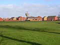 Houses in the northeast part of Berinsfield


References
[edit]- ^UK Census(2011)."Local Area Report – Berinsfield Parish (E04008106)".Nomis.Office for National Statistics.Retrieved5 December2019.
- ^Ordnance Survey (2006).Oxford, Chipping Norton and Bicester (Landranger Maps).Ordnance Survey.ISBN0-319-22913-0.
- ^Boyle et al. 1995,p. xvi
- ^ab"Berinsfield the Community".Berinsfield Parish Council.Retrieved3 August2018.
- ^Ward, Colin (1 September 2004)."The hidden history of housing".History and Policy.Retrieved3 August2018.
- ^Lobel 1962,pp. 39–62.
- ^Sherwood & Pevsner 1974,p. 451.
- ^Sherwood & Pevsner 1974,p. 452.
- ^Abbey Woods Academy
- ^"Berinsfield Library".Oxfordshire County Council.Retrieved5 December2019.
- ^South Oxfordshire District Council: Leisure Centres
- ^"river rapids X38 X39 X40 NX40"(PDF).Thames Travel.Retrieved5 December2019.
Sources
[edit]- Boyle, A; Dodd, A; Miles, D; Mudd, A (1995).Two Oxfordshire Anglo-Saxon Cemeteries: Berinsfield and Didcot.Thames Valley Landscape Series. Vol. 8. Oxford:Oxford UniversitySchool of Archaeology.ISBN0-947816-86-0.
- Lobel, Mary D,ed. (1962). "Dorchester".A History of the County of Oxford.Victoria County History.Vol. 7: Thame and Dorchester Hundreds. London:Oxford University Pressfor theInstitute of Historical Research.pp. 39–64.
- Sherwood, Jennifer;Pevsner, Nikolaus(1974).Oxfordshire.The Buildings of England.Harmondsworth:Penguin Books.pp. 451–452.ISBN0-14-071045-0.
External links
[edit]- Berinsfield Parish Council
 Media related toBerinsfieldat Wikimedia Commons
