
Beskids
| Beskids | |
|---|---|
 Eastern Beskids inZakarpattia Oblast,Ukraine | |
| Highest point | |
| Peak | Babia Góra |
| Elevation | 1,725 m (5,659 ft) |
| Coordinates | 48°09′36″N24°30′01″E/ 48.16000°N 24.50028°E |
| Dimensions | |
| Length | 600 km (370 mi) |
| Width | 70 km (43 mi) |
| Naming | |
| Native name | |
| Geography | |
| Countries | Poland,Slovakia,Czech RepublicandUkraine |
| Regions | Silesia,Lesser Poland,MoraviaandCarpathian Ruthenia |
| Parent range | WesternandEastern Carpathians |
| Borders on | SudetesandTatra Mountains |
TheBeskidsorBeskid Mountains(Polish:Beskidy,Czech:Beskydy,Slovak:Beskydy,Rusyn:Бескиды(Beskydŷ),Ukrainian:Бескиди(Beskydy)) are a series of mountain ranges in theCarpathians,stretching from theCzech Republicin the west along the border ofPolandwithSlovakiaup toUkrainein the east.[1]
The highest mountain in the Beskids isBabia Góra,at 1,725 m metres (5,659 ft).[2]
Etymology
[edit]The origin of the namebeskydyhas not been conclusively established. AThracianorIllyrianorigin has been suggested;[citation needed]however, as yet, no theory has majority support among linguists. The word appears in numerous mountain names throughout the Carpathians and the adjacentBalkanregions, like inAlbanianbjeshkë.According to linguists Çabej and Orel, it is possibly derived fromProto-Albanian*beškāi tāi(meaning 'the mountain pastures').[3][4]The Slovak nameBeskydyrefers to the PolishBieszczady Mountains,which is not a synonym for the entire Beskids but one single range, belonging to theEastern Beskids.According to another linguistic theory, it may be related toMiddle Low Germanbeshêt,beskēt,meaning 'watershed'.[5]
Historically, the term was used for hundreds of years to describe the mountain range separating the oldKingdom of Hungaryfrom the oldKingdom of Poland.In 1269, the Beskids were known by the Latin nameBeschad Alpes Poloniae'Beskid Mountains of Poland'.[6]
Definition
[edit]The Beskids are approximately 600 km (370 mi) in length and 50–70 km (31–43 mi) in width. They stand mainly along the southern border ofLesser Polandwith northern Slovakia, stretching to theMoraviaandCzech Silesiaregions of the eastern Czech Republic and toCarpathian Rutheniain western Ukraine. Parts form theEuropean Watershed,separating theOderandVistulabasins in the north from theEastern Slovak Lowland,part of theGreat Hungarian Plaindrained by theDanubeRiver.
Geologically all of the Beskids stand within theOuter Western Carpathiansand theOuter Eastern Carpathians.In the west they begin at the natural pass of theMoravian Gate,which separates them from theEastern Sudetes,continue east in a band to the north of theTatra Mountains,and end inUkraine.The eastern termination of the Beskids is disputed. According to older sources, the Beskids end at the source of theTiszaRiver, while newer sources state that the Beskids end at theUzhok Passat the Polish–Ukrainian border.
Subdivisions
[edit]


Multiple traditions, languages and nationalities have developed overlapping variants for the divisions and names of the Beskid ranges. According to thedivisions of the Carpathians,they are categorized within:
Western Beskids
[edit]- Western Beskids(Polish:Beskidy Zachodnie,Slovak:Západné Beskydy,Czech:Západní Beskydy)
- Western section of the Western Beskids:
- Hostýn-Vsetín Mountains(Czech:Hostýnsko-vsetínská hornatina) → e1
- Moravian-Silesian Beskids(Czech:Moravskoslezské Beskydy,Slovak:Moravsko-sliezske Beskydy) → e2
- Turzovka Highlands(Slovak:Turzovská vrchovina) → e3
- Jablunkov Furrow(Czech:Jablunkovská brázda) → e4
- Rožnov Furrow(Czech:Rožnovská brázda) → e5
- Jablunkov Intermontane(Slovak:Jablunkovské medzihorie,Czech:Jablunkovské mezihoří) → e6
- Silesian Beskids(Polish:Beskid Śląski,Czech:Slezské Beskydy) → e7
- Żywiec Basin(Polish:Kotlina Żywiecka) → e8
- Northern section of the Western Beskids:
- Little Beskids(Polish:Beskid Mały) → f1
- Maków Beskids(Polish:Beskid Makowski) → f2
- Island Beskids(Polish:Beskid Wyspowy) → f3
- Gorce Mountains(Polish:Gorce) → f4
- Rabka Basin(Polish:Kotlina Rabczańska) → f5
- Sącz Basin(Polish:Kotlina Sądecka) → f6
- Central section of the Western Beskids:
- Orava Beskids(Slovak:Oravské Beskydy) +Żywiec Beskids(Polish:Beskid Żywiecki) (the older Slovak equivalent ofBeskid ZywieckiisSlovenské Beskydy'Slovak Beskids' orKysucko-oravské Beskydy'Kysuce-Orava Beskids') → g1
- Kysuce Beskids(Slovak:Kysucké Beskydy) +Żywiec Beskids(Polish:Beskid Żywiecki) (the older Slovak equivalent ofBeskid ZywieckiisSlovenské BeskydyorKysucko-oravské Beskydy) → g2
- Orava Magura(Slovak:Oravská Magura) → g3
- Orava Highlands(Slovak:Oravská vrchovina) → g4
- Sub-Beskidian Furrow(Slovak:Podbeskydská brázda) → g5
- Sub-Beskidian Highlands(Slovak:Podbeskydská vrchovina) → g6
- Eastern section of the Western Beskids:
- Beskid Sądecki(Polish:Beskid Sądecki) → h1
- Čergov(Polish:Góry Czerchowskie;Slovak:Čergov) → h2
- Pieniny(Polish:Pieniny;Slovak:Pieniny) → h3
- Western section of the Western Beskids:
- West Beskidian Foothills,in the Czech Republic and Poland
- Silesian-Moravian Foothills(Czech:Podbeskydská pahorkatina,Polish:Pogórze Śląsko-Morawskie) → d1
- Silesian Foothills(Polish:Pogórze Śląskie) → d2
- Wieliczka Foothills(Polish:Pogórze Wielickie) → d3
- Wiśnicz Foothills(Polish:Pogórze Wiśnickie) → d4
Central Beskids
[edit]

- Central Beskids(Polish:Beskidy Środkowe) orLow Beskids(Slovak:Nízke Beskydy)
- Busov,in Slovakia
- Ondava Highlands(Slovak:Ondavská vrchovina)
- Low Beskid(Polish:Beskid Niski) +Laborec Highlands(Slovak:Laborecká vrchovina)
- Beskidian Southern Foothills(Slovak:Beskydské predhorie)
- Central Beskidian Piedmont,in Poland
- Rożnów Piedmont(Polish:Pogórze Rożnowskie)
- Ciężkowice Piedmont(Polish:Pogórze Ciężkowickie)
- Strzyżów Piedmont(Polish:Pogórze Strzyżowskie)
- Dynów Piedmont(Polish:Pogórze Dynowskie)
- Przemyśl Piedmont(Polish:Pogórze Przemyskie)
- Gorlice Depression(Polish:Obniżenie Gorlickie)
- Jasło-Krosno Basin(Polish:Kotlina Jasielsko-Krośnieńska)
- Jasło Piedmont(Polish:Pogórze Jasielskie)
- Bukowsko Piedmont(Polish:Pogórze Bukowskie)
Eastern Beskids
[edit]
Eastern Beskidsare divided into two parallel ridges: Wooded Beskids and Polonynian Beskids.
- Wooded Beskids(Polish:Beskidy Lesiste;Ukrainian:Лісисті Бескиди)
- Bieszczady Mountains(Polish:Bieszczady;Ukrainian:Бещади) → c1
- Sanok-Turka Mountains(Polish:Góry Sanocko-Turczańskie;Ukrainian:Верхньодністровські Бескиди) → c3
- Skole Beskids(Polish:Beskidy Skolskie;Ukrainian:Сколівські Бескиди) → c2
- Gorgany(Polish:Gorgany;Ukrainian:Ґорґани) → c4
- Pokuttia-Bucovina Beskids(Polish:Beskidy Pokucko-Bukowińskie;Ukrainian:Покутсько-Буковинські Карпати) → c5
- Polonynian Beskids(Polish:Beskidy Połonińskie;Ukrainian:Полонинські Бескиди)
- Smooth Polonyna(Ukrainian:Полонина Рівна) → c6
- Polonyna Borzhava(Ukrainian:Полонина Боржава) → c7
- Polonyna Kuk(Ukrainian:Полонина Кук) → c8
- Red Polonyna(Ukrainian:Полонина Красна)→ c9
- Svydovets(Ukrainian:Свидівець) → c10
- Chornohora(Ukrainian:Чорногора) → c11
- Hrynyavy Mountains(Ukrainian:Гриняви) → c12
Infrastructure
[edit]The Beskids are currently rich inforestandcoal.In the past they were rich iniron ore,with important plants inOstravaandTřinec–Třinec Iron and Steel Works.
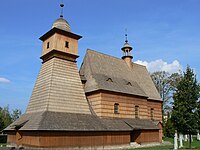
There are many tourist attractions, including historic wooden churches (seeWooden Churches of Southern Little Poland,Carpathian Wooden Churchesof Slovakia, andWooden Churches of Ukraine) and the increasingly popularskiingresorts.
A number of environmental groups support a small but growing population of bears, wolves and lynx in the ecosystem of the Beskidy mountains. The Central Beskids include the PolishBabia Góra National Parkand the adjacent SlovakHorná Orava Protected Landscape Area.
Gallery
[edit]-
 Map of the Beskid ranges in Slovakia and Poland
 -
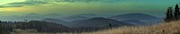
 Czantoria,Silesian Beskids
 -
 WesternBieszczady
 -
 WesternBieszczady
 -
-
 Wooden church inKwiatoń
 -
 Wooden church in Hrabova, Moravia (14th century – 1564)
 -
 Shepherds inSilesian Beskids
 -


See also
[edit]Citations
[edit]- ^Encyclopedia of Ukraine: Beskyds
- ^Merriam-Webster's Geographical Dictionary.3. vyd. Springfield, Massachusetts, U. S. A.: Merriam-Webster, Incorporporated, Publishers, 1997. 1361 s. ISBN 0-87779-546-0. S. 139.
- ^Çabej, E. (1976). Studime Gjuhësore I, Studime Etimologjike në Fushë të Shqipes, A-O. Priština: Rilindja, page 68
- ^Orel, Vladimir(1998). "Beskids".Albanian Etymological Dictionary.Leiden, Boston, Cologne: Brill. p. X.ISBN9004110240.
- ^Zbigniew Gołąb.The Origins of the Slavs: A Linguist's View.Slavica Publishers, Inc., 1992 p. 342. "The Germanic etymology of Bieszczad // Beskid was proposed by Prof. Jan Michał Rozwadowski (1914:162, etc.). He derives the variantbeščadfrom Germc.biskaid,which is represented by MLGbesche(beskêt)Trennungand by Scandinavianbêsked,borrowed from [...] "
- ^Kazimierz Zarzycki, Zbigniew Głowaciński (1986): Bieszczady (p. 7)
General and cited sources
[edit]- Földvary, Gábor Z. (1988).Geology of the Carpathian Region.Singapore: World Scientific Publishing Company.
- Kondracki, Jerzy (1977).Regiony fizycznogeograficzne Polski.Warszawa: Wydawa Uniwersytetu Warszawskiego.
- Kondracki, Jerzy (1989).Problemy standaryzacji nazw geograficznych.Warszawa: Instytut Geografii i Przestrzennego Zagospodarowania PWN.
- Kondracki, Jerzy (2000) [1998].Geografia regionalna Polski(2. ed.). Warszawa: Wydawnictwo Naukowe PWN.ISBN9788301130503.
- Świstuń, Filip.Galicyjskie Beskidy i Karpaty Lesiste: Zarys orograficzn.Rzeszow, 1876.
- Tasenkevich, Lydia (2009). "Polonynas: Highlands Pastures in the Ukrainian Carpathians".Grasslands in Europe: Of High Nature Value.Zeist: KNNV Publishing. pp. 203–208.ISBN9789004278103.
External links
[edit]- Encyclopedia of Ukraine: Western Beskyd
- Encyclopedia of Ukraine: Low Beskyd
- Encyclopedia of Ukraine: Middle Beskyd
- Encyclopedia of Ukraine: High Beskyd
- Encyclopedia of Ukraine: Polonynian Beskyd
- Encyclopedia of Ukraine: Hutsul Beskyd
- Carpathian Mountains: Division (map)
| International | |
|---|---|
| National | |
| Other | |