
Bhalia
Bhalia | |
|---|---|
Village | |
 Bhalia Location inWest Bengal,India  Bhalia Bhalia (India) | |
| Coordinates:22°53′47″N87°51′44″E/ 22.8963°N 87.8623°E | |
| Country | |
| State | West Bengal |
| District | Hooghly |
| Population (2011) | |
| • Total | 2,452 |
| Languages | |
| • Official | Bengali,English |
| Time zone | UTC+5:30(IST) |
| PIN | 712615 |
| Telephone/STDcode | 03211 |
| Lok Sabhaconstituency | Arambagh |
| Vidhan Sabhaconstituency | Arambag |
| Website | hooghly |
Bhaliais a village in theArambaghCD blockin theArambagh subdivisionofHooghly districtin theIndianstateofWest Bengal.
Geography
[edit]
5miles
River
River
River
River
Bayara
M: municipal city/ town, R: rural/ urban centre, H: historical/ religious centre
Owing to space constraints in the small map, the actual locations in a larger map may vary slightly
Location
[edit]Bhalia is located at22°53′47″N87°51′44″E/ 22.8963°N 87.8623°E
Area overview
[edit]The Arambagh subdivision, presented in the map alongside, is divided into two physiographic parts – theDwarakeswarRiver being the dividing line. The western part is upland and rocky – it is extension of the terrain of neighbouringBankuradistrict. The eastern part is flat alluvial plain area. The railways, the roads and flood-control measures have had an impact on the area.[1]The area is overwhelmingly rural with 94.77% of the population living in rural areas and 5.23% in urban areas.[2]
Note: The map alongside presents some of the notable locations in the subdivision. All places marked in the map are linked in the larger full-screen map.
Demographics
[edit]According to the2011 Census of India,Bhalia had a total population of 2,452 of which 1,241 (51%) were males and 1,211 (49%) were females. Population in the age range 0–6 years was 265. The total number of literate persons in Bhalia was 1,690 (77.27% of the population over 6 years).[3]
Culture
[edit]David J. McCutchionmentions the Raghunatha temple of Sarkar family as anat chalawithporchon triple archway, built in 1772 and measuring 24’ x 23’.[4]
Bhalia picture gallery
[edit]-
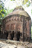 Raghunatha temple of Sarkar family,at chala,built in 1772
 -
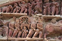 Terracotta relief in Raghunatha temple
 -
 Terracotta relief in Raghunatha temple


References
[edit]- ^"District Census Handbook: Hugli, Series-20, Part XIIA"(PDF).Physiography, Page 17-19.Directorate of Census Operations, West Bengal, 2011.Retrieved25 September2020.
- ^"District Statistical Handbook 2014 Hooghly".Table 2.2, 2.4(a).Department of Planning and Statistics, Government of West Bengal.Retrieved25 September2020.
- ^"2011 Census – Primary Census Abstract Data Tables".West Bengal – District-wise.Registrar General and Census Commissioner, India.Retrieved22 September2020.
- ^McCutchion, David J.,Late Mediaeval Temples of Bengal,first published 1972, reprinted 2017, page 35. The Asiatic Society, Kolkata,ISBN978-93-81574-65-2