
Bishopsgate
| Ward of Bishopsgate | |
|---|---|
 Ac. 1650print of the gate | |
 Bishopsgate Ward within the city - after the boundary changes of 1994 and 2003 | |
 Ward of Bishopsgate Location withinGreater London | |
| Population | 222 (2011 Census Ward)[1] |
| OS grid reference | TQ330813 |
| Sui generis | |
| Administrative area | Greater London |
| Region | |
| Country | England |
| Sovereign state | United Kingdom |
| Post town | LONDON |
| Postcode district | EC2 |
| Dialling code | 020 |
| Police | City of London |
| Fire | London |
| Ambulance | London |
| UK Parliament | |
| London Assembly | |
Bishopsgatewas one of the eastern gates inLondon's former defensive wall.The gate's name is traditionally attributed toEarconwald,who wasBishop of Londonin the 7th century. It was first built inRomantimes and marked the beginning ofErmine Street,the ancient road running from London toYork(Eboracum). The gate was rebuilt twice in the 15th and 18th centuries, but was permanently demolished in 1760.
Bishopsgate gave its name to the BishopsgateWardof theCity of London.The ward is traditionally divided intoBishopsgate Within,inside the line of the former wall, andBishopsgate Withoutbeyond it.Bishopsgate Withoutis described as part ofLondon's East End.[2]The ancient boundaries of the City wards were reviewed in 1994 and 2013, so that the wards no longer correspond very closely to their historic extents.Bishopsgate Withoutgained a significant part ofShoreditchfrom theLondon Borough of Hackney,while nearly all ofBishopsgate Withinwas transferred to other wards.
Bishopsgate is also the name of the street, being the part of the originally RomanErmine Street(now theA10) within the traditional extent of the Ward.
The gate[edit]
The gate was first built in theRomanera, probably at the time the wall was first built. The road though the gate,Ermine Street(known at this point as Bishopsgate) was in place long before the wall and the gate.

The gate is traditionally held to be named afterEarconwald,a 7th-centuryBishop of London[3](Bishop of theEast Saxons).[4]One of the ward's ancient churches,St Ethelburga-the-Virgin within Bishopsgate,is dedicated to Eorconwald's sister,St Ethelburga of Barking,the first Abbess ofBarking Abbey.
In 1471, during theWars of the Roses,the Yorkist-turned supporter of the House of LancasterBastard Fauconbergattacked London, trying to force his way across London Bridge and also attacking the eastern gates with a further five thousand men and artillery.[5]Bishopsgate was set on fire[6]and the attackers came close to capturing nearbyAldgateand with it the city. The attackers were repulsed from both gates with heavy losses, before being chased back toBow BridgeandBlackwall.
The Bishop's Gate was rebuilt by theHansa merchantsin 1471 in exchange forsteelyardprivileges. Its final form was erected in 1735 by the City authorities, but demolished in 1760. This gate often displayed the heads of criminals on spikes. London Wall (which is no longer extant in this sector) divided the ward and road into an intramural portion called Bishopsgate Within and an extramural portion called Bishopsgate Without.
The site of this former gate is marked by a stone bishop'smitre,fixed high upon a building located near Bishopsgate's junction withWormwood Street,by the gardens there and facing theHeron Tower.
Ward[edit]
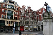
The ward is notable for its skyscrapers, and is home to the main London offices of several major banks, includingNational Westminster Bankand theEuropean Bank for Reconstruction and Development.Although tens of thousands of people commute to and work in the ward, it has a resident population of only 222 (2011).[7]
The ward is divided into two parts by the line of the formerLondon Walland gate which lay just north ofWormwoodandCamomileStreets.

Bishopsgate Without[edit]
Bishopsgate Withoutcorresponds to the parish ofSt Botolph-without-Bishopsgate.The church is located immediately north of the site of the original Gate on the west side of the road. The church was one of four in medieval London dedicated to Saint Botolph orBotwulf,a 7th-centuryEast Angliansaint; three of these were outside city gates, with a fourth near London Bridge and the riverside wharves. The locations result from Botolph being regarded as thepatron saintof boundaries, and by extension of trade and travel.[8]

The eastern boundary ofBishopsgate Withoutis formed byMiddlesex Street (better known as Petticoat Lane),withBlomfield Streeton the western boundary. Blomfield Street was built on part of the historic course of the formerRiver Walbrook,known at this point asDeepditch.BeyondDeepditchwas theMoorfields(inColeman Street Ward).[9]The Blomfield Street section of the river was the focal point of theWalbrook Skulls;the result of the deposit of large quantities of decapitated Roman-era human skulls into the water.[10]These are still often uncovered during building work.
Bishopsgate Withoutwas, from 1247 to 1633, the first home of theBethlem Royal Hospital (also known as Bedlam).This psychiatric hospital lay immediately north of St Botolph's church.


Around 1597, the merchantSir Paul Pindar,purchased several existing properties, and built himself a new home on the site (incorporating part of one or more of the old properties). The house had a fairly narrow frontage but extended a long way back. Bishopsgate Street had recently been paved, making the site convenient for Pindar's business activities inEast Anglia.The house had views over the open space in nearbyMoorfieldsandFinsbury Fields,west of the Walbrook.[11]The house was soon prestigious enough to be used as a base by several foreigh ambassadors, including theVenetianambassadorPietro Contariniin 1617–18.[12]
The district was then on the edge of London, something Contarini had mixed feelings about, describingBishopsgate Withoutas "…an airy and fashionable area…a little too much in the country"[13]
In the 1600s,Bishopsgate Without,together with neighbouringBethnal GreenandSpitalfieldswas home to manyHuguenotrefugees, many of them weavers.[14]In the late 1600s wealthy residents began to migrate to the newly developed areas ofWest End of Londonand the character of the area began to change,[15]partly due to the more prosperous parts of the community leaving, and partly to the densification of the area and rapid urbanisation of the neighbouring rural areas.
In time, the East and West Ends of London became more strikingly different in character, writing of the period around 1800, Rev. Richardson commented:
The inhabitants of the extreme east of London knew nothing of thewestern localitiesand vice-versa. There was little communication or sympathy between the two ends of London.
…and thus the householders ofWestminsterwere as distinct from householders ofBishopsgate Without,Shoreditchand all those localities which stretch towards theEssexside of the city, as they are from the inhabitants of Holland or Belgium.
— Rev. J. Richardson (1856)[16]
Bishopsgate Withoutwas a very densely populated neighbourhood, prior to the opening (1874) and later expansion (1891) ofLiverpool Street station,which now dominates the area. The initial opening of the station saw 3,000 residents of Bishopsgate Without evicted and their homes demolished. Around 7,000 people in neighbouringShoreditchalso lost their homes to the railway tracks feeding into the station.[17]
Notable buildings include:
- Broadgate Tower
- Heron Tower
- Liverpool Street station
- Great Eastern Hotel
- Bishopsgate Institute
- Broadgate Estate
- Dirty Dick's (a 200 year old pub)
- Bishopsgate Victorian Bath House

Bishopsgate Within[edit]
Bishopsgate Withinwas originally divided into many parishes, each with its own parish church:St Andrew Undershaft,St Ethelburga Bishopsgate,St Martin Outwich,St Mary AxeandSt Helen's Bishopsgate,now all amalgamated under the last of these. St Helen's is a historic medieval church and former monastic establishment with many ancient funerary monuments and a stained glass window commemoratingWilliam Shakespeare,a local parishioner in the early to mid-1590s. The area was well located for Shakespeare, being close to the theatres in Shoreditch where he worked;The Theatreand theCurtain Theatre.
Notable buildings include:
Ward boundary changes[edit]
The 1994 (city), 2003 and 2013 (ward) boundary revisions made fundamental changes to the ancient boundaries of the ward. The 1994 changes sawBishopsgate Without(and with it the City of London) gain a large area from theShoreditcharea of theLondon Borough of Hackney,[18]
The changes made in 2003 and 2013[Need clarity on these reviews]shifted land between wards of the city. The effect of this was to transfer nearly all ofBishopsgate Within(except for a small area surrounding theLeathersellers' livery hall) to other wards.[19]The ward previously extended much further south, along the Bishopsgate road and Gracechurch Street. At this timeBishopsgate Withoutlost a small block of buildings east Blomfield Street to the Broad Street ward.
There were no changes to Bishopsgate's ward boundaries in the 2013 boundary changes.[19]
The revised ward borders theLondon Borough of Hackneyto the north, it neighboursThe Portsokenand theborough of Tower Hamletsin the east. The other neighbours areAldgate(southeast),Coleman Street(west),Cornhill(south-west),Broad StreetandLime Street(south).
Politics[edit]
Bishopsgate is one of 25wardsin theCity of London,each electing anAldermanto theCourt of Aldermen,and Commoners (the City equivalent of a councillor) to theCourt of Common Councilof theCity of London Corporation.Only electors who areFreemen of the City of Londonare eligible to stand. On 15 September 2022 the ward elected Kawsar Zaman as its Alderman.[20]He is only the third non-white Alderman in the city's hundreds of years of history, the firstBritish-Bangladeshiever to hold the office, and the youngest ever elected to the Court of Alderman.
Street[edit]
The street called Bishopsgate (formerly Bishopsgate Street), which takes its name from the Gate, is the main thoroughfare of the Ward. It is a stretch of the originally RomanErmine Street(now theA10) betweenGracechurch StreetandNorton Folgate,[21]taking the name Bishopsgate only within the historical area of the ward.
Although it takes its name from the gate, the road pre-dates the building of theLondon Wallwhich was built in the late second or early third centuries. Ermine Street (sometimes called the Old North Road) connected London toCambridge,Lincoln,Yorkand other towns and cities.
History[edit]
Early history[edit]
In the Roman period it was illegal to bury the dead within the city, so cemeteries were established outside the city gates. There were large burial grounds outside Bishopsgate, on both side ofErmine Street.[22]

The wards of London appear to have taken shape in the 11th century, before the Norman Conquest. Their administrative, judicial and military purpose made them equivalent tohundredsin the countryside. The primary purpose of wards like Bishopsgate, which included a gate, appears to be the defence of the gate,[23]as gates were the weakest points in any fortification.

The earliest origins of the wards reach back further than the 11th century but their emergence and evolution is uncertain and any narrative conjectural.[24]The ward may have developed from theSoke of Bishopsgate,a set of rights, and possibly land, held by the Bishop of London over an area to the east of theRiver Walbrook.The Bishop may have been granted the land and rights in order to promote growth in the under-developed part of the city east of theWalbrook.Outside the wall the Walbrook formed the boundary between the Soke of Bishopsgate to the east and theSoke of Cripplegateon the other side of the brook.[25]
Bishopsgate may have originally included the area that subsequently became known asLime Street Ward.[26]
The Domesday Survey of 1086 did not cover London, but a landholding called Bishopsgate is recorded nearby; this may have been the property later known asNorton Folgate.[27]
Coaching inns[edit]
Bishopsgate had manycoaching innswhich accommodated passengers setting out on the originally RomanErmine Street,that issued from the gate. Although they survived theGreat Fire of London,they have now all been demolished. These included the Angel, the Black Bull, the Dolphin, the Flower Pot, the Green Dragon, the Magpie and Punchbowl, the White Hart and the Wrestlers. The Black Bull was a venue for theQueen's Mentheatrical troupe in the 16th century.[28]The English politicianAnthony Baconmoved nearby with his mother in May 1594 and she complained about the plays and interludes at the Bull which might "corrupt his servants".[29]

An inn called the Catherine Wheel (demolished 1911) is commemorated by Catherine Wheel Alley which leads off Bishopsgate to the east.[30]The 17th century façade of SirPaul Pindar's House on Bishopsgate, demolished, with many other old buildings, for the expansion ofLiverpool Street railway stationin 1890, was also preserved and can now be seen in theVictoria and Albert Museum.In the 18th century this grand residence became a tavern called Sir Paul Pindar's Head;[31]another notable venue was theLondon Tavern(1768–1876). Also demolished (but then re-erected inChelseain 1910) was the oldCrosby Hall,at one time the residence ofRichard IIIandThomas More.
Bishopsgate Mutiny[edit]
In 1649, during theWars of the Three Kingdoms,Colonel Whalley's Regiment,a parliamentary unit, was stationed in Bishopsgate Ward, helping to protect London from Royalists. TheBishopsgate mutinyoccurred when soldiers of the regiment, mutinied against parliament - partly due to their radicalLevellersympathies. A surrender was eventually negotiated, butRobert Lockyera parishioner ofBishopsgate Withoutas well as a soldier in the regiment, was executed as a ringleader.
Communist Manifesto[edit]
The Communist Manifestowas first printed, anonymously and in German, by the Workers Educational Association at 46 Liverpool Street in Bishopsgate Without in 1848.[32]
Terrorist attack[edit]
On 24 April 1993, it was the site ofan IRA truck bombingwhich killed journalist Ed Henty, injured over 40 people and caused £1 billion worth of damage,[33]including the destruction of St Ethelburga's church and damage to theNatWest TowerandLiverpool Street station.Police had received a coded warning, but were still evacuating the area at the time of the explosion. The area had already suffered damage from theBaltic Exchange bombingone year before.[citation needed]
St Ethelburga's was rebuilt, functioning not just as a church but also as home to theSt Ethelburga's Centre for Reconciliation and Peacecharity.
Gallery[edit]
-
 Bishopsgate and the extramural part of Bishopsgate Street, as shown on the"Copperplate" map of Londonof the 1550s
 -
 The bishop'smitreat Bishopsgate's junction withWormwood Street
 -
 A formerLondon Fire Brigadestation on Bishopsgate (designed byRobert Pearsall), now a supermarket
 -
 The southernmost portion of Bishopsgate pictured in 1955, looking north toward theNational Provincial Bank
 -
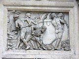 Bas relief on theformer National Provincial Bank
 -
-
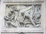
 Overview of another part ofthe building


See also[edit]
References[edit]
- ^"City of London ward population 2011".Neighbourhood Statistics.Office for National Statistics. Archived fromthe originalon 8 April 2017.Retrieved16 October2016.
- ^Beyond the Tower: a history of East London. by John Marriot. In it refers back to 18th century descriptions of Bishopsgate Without and Shoreditch as EE districts
- ^Ben Weinreb andChristopher Hibbert(1983) The London Encyclopedia
- ^On the Diocese of London originally serving the East Saxons"Our History".London Diocesan Board for Schools.8 February 2021.Archivedfrom the original on 21 July 2021.Retrieved21 July2021.
- ^"Siege of London, 12-15 May 1471".Military History Encyclopedia on the Web.9 September 2007.Archivedfrom the original on 1 February 2020.Retrieved21 July2021.
- ^Kentish Rising section "The Wars of the Roses – Descriptions of Battles".Richard III Society.Archived fromthe originalon 30 July 2020.Retrieved21 July2021.
- ^"Local statistics - Office for National Statistics".neighbourhood.statistics.gov.uk.Archived fromthe originalon 8 April 2017.Retrieved24 April2013.
- ^Churches in the Landscape, p217-221, Richard Morris,ISBN0-460-04509-1
- ^BHO source on the Moorfields area"Historical introduction: Moorfields".British History Online.21 July 2021. pp. 88–90.Archivedfrom the original on 24 June 2021.Retrieved21 July2021.
- ^London's Hadrianic War? Dominic Perring
- ^Victoria and Albert Museumhttps://www.vam.ac.uk/articles/sir-paul-pindars-houseArchived3 October 2023 at theWayback Machine
- ^London Merchants and their residencesgresham.ac.uk Archived5 October 2023 at theWayback Machine
- ^City of London Conservation Areahttps://www.cityoflondon.gov.uk/assets/Services-Environment/bishopsgate-conservation-area-character-summary-management-strategy.pdfArchived4 April 2022 at theWayback Machine
- ^Eppie Evans, The Influence of Foreignness, The Influence of 'Foreignness': How Immigration and Imported Commodities affected Englandhttps://sas-space.sas.ac.uk/5774/1/Eppie__Evans_-_The_Influence_of_%27Foreignness%27.pdfArchived14 September 2021 at theWayback Machine
- ^Management strategycityoflondon.gov.uk Archived4 April 2022 at theWayback Machine
- ^Recollections of the last half century, Mitchel, 1856
- ^London Encyclopaedia, Weinreb and Hibbert, 1983
- ^The legislation transferring additional areas to the City of London"The City and London Borough Boundaries Order 1993".legislation.gov.uk.1 December 1993.Archivedfrom the original on 21 July 2021.Retrieved21 July2021.
- ^abCity of London CorporationArchived12 June 2011 at theWayback MachineWard boundary review 2010 (final recommendations) – see page 15
- ^"Election results".City of London.Archived fromthe originalon 20 September 2022.Retrieved19 September2022.
- ^The City of London-a history Borer, M.I.C.: New York, D.McKay Co, 1978ISBN0-09-461880-1.
- ^Descriptions of cemetery site in adjacent Spitalfields gives extensive backgroundSudds, Berni; Douglas, Alistair; Phillpotts, Christopher."EXCAVATIONS AT CRISPIN STREET, SPITALFIELDS: FROM ROMAN CEMETERY TO POST-MEDIEVAL ARTILLERY GROUND"(PDF).lamas.org.uk.Archived(PDF)from the original on 19 June 2021.Retrieved21 July2021.
- ^London 800-1216: The Shaping of a City, Brook and Keir Ch 7
- ^London 800-1216: The Shaping of a City, Brook and Keir. On p156-7 refers to William Pages discussion of the emergence of Wards but asserts the statements while valuable are unavoidably conjectural
- ^Statements and conjecture passim from London, its origin and early development, William Page, 1923
- ^London, its origin and early development, William Page, 1923, p176
- ^See section called A HISTORY OF THE MANOR AND LIBERTY OF NORTON FOLGATE"A HISTORY OF LOCAL GOVERNMENT IN SPITALFIELDS".Spitalfields Forum.Archivedfrom the original on 7 February 2022.Retrieved21 July2021.
- ^Wood 2003: 124-8
- ^Thomas Birch,Memorials of the Reign of Queen Elizabeth,vol. 1 (London, 1754), p. 173.
- ^Weinreb and Hibbert (1983: 127)
- ^Weinreb and Hibbert 1983: 586
- ^Bosmajian, Haig A."A RHETORICAL APPROACH TO THE COMMUNIST MANIFESTO"(PDF).dalspace.library.dal.ca.Archived(PDF)from the original on 7 August 2021.Retrieved21 July2021.
- ^De Baróid, Ciarán (2000).Ballymurphy And The Irish War.Pluto Press.p. 325.ISBN0-7453-1509-7.
External links[edit]
- Ward map from the Corporation of London
- Bishopsgate ward newsletter
- Map of Early Modern London, with scholarly commentary. Bishopsgate is in grid square B6, right side.
- Pubs within the City of London
- Bishopsgate Ward Club
- Michael Wood(2003)In Search of Shakespeare.London: BBC Worldwide.
- Mention inBeing for the Benefit of Mr. Kite!by the Beatles: "The celebrated Mr. K. performs his feat on Saturday at Bishopsgate."
- St Helen's Bishopsgate
| Wards | |
|---|---|
| Enclaves | |
| Localities | |
| Attractions |
|
| Notable structures | |
| Civil parishes | |
| Bridges | |
| Rail and tube stations | |
| Topics | |
Gatesand bars of theCity of London | |||
|---|---|---|---|
 | Former gates ofLondon WallandCity bars
Listed clockwise from the West
| ||