Bobrowniki
Bobrowniki | |
|---|---|
Town | |
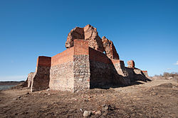
 Ruins of the castle | |
| Coordinates:52°46′36″N18°57′26″E/ 52.77667°N 18.95722°E | |
| Country | |
| Voivodeship | Kuyavian-Pomeranian |
| County | Lipno |
| Gmina | Bobrowniki |
| Population | |
| • Total | 980 |
| Time zone | UTC+1(CET) |
| • Summer (DST) | UTC+2(CEST) |
| Vehicle registration | CLI |
| Website | http://ugbobrowniki.pl/ |
Bobrowniki([bɔbrɔvˈniki]) is a town inLipno County,Kuyavian-Pomeranian Voivodeship,in central Poland.[1]It is the seat of thegmina(administrative district) calledGmina Bobrowniki.It lies approximately 17 kilometres (11 mi) south-west ofLipnoand 37 km (23 mi) south-east ofToruń.In the Middle Ages the town was one of the centres of theDobrzyń Land.
Near Bobrowniki, there is a remarkablepower line crossingof theVistulariver.
History
[edit]The town contains ruins of thecastle,built at the end of 14th century byTeutonic Knightsat the place of a former Polishgród.
During theGerman occupation of Poland(World War II), several local farmers and activists were among the victimes of a massacre ofPoles,perpetrated by the Germans in nearbyRadomiceon October 8, 1939 as part of the genocidalIntelligenzaktioncampaign.[2]Local Polish teachers were arrested and imprisoned inWłocławek,and two local school principals were sent toNazi concentration campsand murdered there.[3]
References
[edit]- ^"Central Statistical Office (GUS) - TERYT (National Register of Territorial Land Apportionment Journal)"(in Polish). 2008-06-01.
- ^Wardzyńska, Maria (2009).Był rok 1939. Operacja niemieckiej policji bezpieczeństwa w Polsce. Intelligenzaktion(in Polish). Warszawa:IPN.p. 175.
- ^Wardzyńska, pp. 176, 180–181


