
Sund, Åland
Sund | |
|---|---|
Municipality | |
| Sunds kommun | |
 Kastelholm Castle in 2004 | |
 Coat of arms | |
 Location of Sund inFinland | |
 Sund Location in Åland | |
| Coordinates:60°15′N020°07′E/ 60.250°N 20.117°E | |
| Country | |
| Region | Åland |
| Sub-region | Countryside sub-region |
| Government | |
| • Municipal manager | Andreas Johansson |
| Area (2018-01-01)[1] | |
| • Total | 184.32 km2(71.17 sq mi) |
| • Land | 108.21 km2(41.78 sq mi) |
| • Water | 76.06 km2(29.37 sq mi) |
| • Rank | 295th largestin Finland |
| Population (2023-12-31)[2] | |
| • Total | 995 |
| • Rank | 294th largestin Finland |
| • Density | 9.2/km2(24/sq mi) |
| Population by native language | |
| •Swedish | 88% (official) |
| •Finnish | 4.4% |
| • Others | 7.5% |
| Population by age | |
| • 0 to 14 | 15.5% |
| • 15 to 64 | 58.3% |
| • 65 or older | 26.2% |
| Time zone | UTC+02:00(EET) |
| • Summer (DST) | UTC+03:00(EEST) |
| Website | www.sund.ax |
Sundis amunicipalityofÅland.It is anautonomous territoryofFinland,and one of the official 27national landscapes of Finland.
The municipality has a population of 995 (31 December 2023)[2]and covers an area of 184.32 square kilometres (71.17 sq mi) of which 76.06 km2(29.37 sq mi) is water.[1]Thepopulation densityis 9.2 inhabitants per square kilometre (24/sq mi).
The municipality isunilinguallySwedish-speakingwith around 88.41% of the residents of Sund speaking theSwedish languageas theirmother tongue.Only 4.40% of the residents of Sund speak theFinnish languageas their mother tongue.[6]Sund is the third most Swedish-speaking municipality within Finland.
The old Medieval post route fromStockholm,SwedentoTurku,Finland passes through Sund.
History[edit]
Sund was not populated by humans until theBronze Age,however a permanentsettlementwas only first established in the 5th century by theSwedes.It is suspected that there may have been a partial Finnish settlement due to the existence of a village called Finby.
TheSund churchwas built by the end of the 13th century[7]and theKastelholm Castlewas also built at the end of the 14th century on a small island and it became theadministrative centreof theÅlandregion until losing importance in 1634 and later on in 1745 following country reforms and fire damage.[8]KingJohn III of Swedenkept his deposed brotherEric XIVin captivity in the Kastelholm castle in Autumn 1571. Sund is estimated to have had around 900 inhabitants in 1571 in accordance to the Silver Tax List of that same year.
Following the Russian victory in theFinnish War of 1808-1809,the Russians began to build theBomarsund Fortressin Sund in 1832 in accordance with the orders ofTsar Nicholas Ito strengthen the western border, however when theCrimean Warbegan the Fortress was only half-finished, the Bommarsund Fortresssurrendered to British forces,who demolished it. In theTreaty of Paris,it was concluded that the Åland islands is not to be fortified.
Economy[edit]
Tourism is one of the biggest lines of business in Sund. Agriculture is also popular, especially keeping livestock.[citation needed]Small businesses are also abundant and the biggest employers are the municipality and the local golf course.[citation needed]
Demographics[edit]
Population[edit]
Sund had a small population of around 1020 in 2020, however it lowered to 995 in 2023. Sund is a municipality with nourban areas.At the end of 2017, there were 1,031 inhabitants in Sund, of which 1,019 lived in sparsely populated areas and the residences of 12 were unknown.[9]Sund has 28 villages within its municipality: Berg, Björby, Bomarsund, Brändbolstad, Domarböle, Finby, Gesterby, Gunnarsby, Hulta, Högbolstad, Jussböle, Kastelholm; Kulla, Lappböle, Lövvik, Mångstekta, Persby, Prästgården, Rosenberg, Sibby, Smedsböle, Strömbolstad, Sundby, Svensböle, Tosarby, Tranvik, Träsk and Vivasteby.[10]
| Year | Population |
|---|---|
| 1980 | 939
|
| 1985 | 920
|
| 1990 | 948
|
| 1995 | 968
|
| 2000 | 1,013
|
| 2005 | 1,031
|
| 2010 | 1,019
|
| 2015 | 1,031
|
| 2020 | 1,020
|
| 2023 | 995
|
Politics[edit]
In the2023 legislative elections,Sund voted as such:[11]
- Åland Centre-29,8 %
- Non-aligned Coalition-24,4 %
- Liberals for Åland-22,5 %
- Åland Social Democrats-10,6 %
- Moderate Coalition for Åland- 6,5 %
- Sustainable Initiative- 4,3 %
- Future of Åland- 1,9 %
Notable people[edit]
- G. A. Wallin(1811–1852), explorer andorientalist
Image gallery[edit]
-
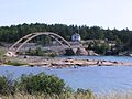 Bridge to Prästö in Sund municipality
 -
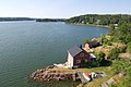 View from the bridge between Sund and Finström
 -
 Church of Sund parish
 -
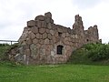 Bomarsund, Åland


References[edit]
- ^ab"Area of Finnish Municipalities 1.1.2018"(PDF).National Land Survey of Finland.Retrieved30 January2018.
- ^ab"Population growth biggest in nearly 70 years".Population structure. Statistics Finland. 2024-04-26.ISSN1797-5395.Retrieved2024-04-29.
- ^"Population growth biggest in nearly 70 years".Population structure. Statistics Finland. 2024-04-26.ISSN1797-5395.Retrieved2024-04-29.
- ^"Population according to age (1-year) and sex by area and the regional division of each statistical reference year, 2003–2020".StatFin.Statistics Finland.Retrieved2 May2021.
- ^ab"Luettelo kuntien ja seurakuntien tuloveroprosenteista vuonna 2023".Tax Administration of Finland. 14 November 2022.Retrieved7 May2023.
- ^"Population 31.12. by Area, Language, Sex, Year and Information".PxWeb.Retrieved2024-03-01.
- ^Hiekkanen, Markus; Jokela, Salla (2007).Suomen keskiajan kivikirkot.Suomalaisen Kirjallisuuden Seuran toimituksia. Helsinki: Suomalaisen Kirjallisuuden Seura.ISBN978-951-746-861-9.
- ^"Kastelholms slott | Ålands Museum".www.museum.ax.Retrieved2024-03-01.
- ^"Taajama- ja haja-asutusalueväestö iän ja sukupuolen mukaan kunnittain 31.12.2017".Tilastokeskus. 28 September 2017. Archived fromthe originalon 14 July 2019.Retrieved6 December2018.
- ^"Invånarantalet i byar och stadsdelar 1990–2012"(in Swedish). Ålands statistik- och utredningsbyrå (ÅSUB). Archived fromthe original(XLS)on 6 July 2015.Retrieved18 April2013.
- ^"Resultat | Lagtingsval 2023 | Sund | valresultat.ax".Valrapport(in Swedish).Retrieved2024-03-11.
External links[edit]
![]() Media related toSund, Ålandat Wikimedia Commons
Media related toSund, Ålandat Wikimedia Commons
- Municipality of Sund– Official website
- Map of Sund municipality