Bregenzer Ach
Appearance
| Bregenzer Ach | |
|---|---|
 Mouth of the river onUpper Lake Constance | |
| Location | |
| Country | Austria |
| State | Vorarlberg |
| Physical characteristics | |
| Source | |
| • location | Mohnenfluhin theBregenz Forest MountainsnearSchröcken |
| • elevation | 2,400 m (7,900 ft) |
| Mouth | |
• location | Lake ConstanceatHard |
• coordinates | 47°30′12″N9°41′37″E/ 47.50333°N 9.69361°E |
• elevation | 395 m (1,296 ft) |
| Length | 67.0 km (41.6 mi)[1] |
| Basin size | 832 km2(321 sq mi)[1] |
| Basin features | |
| Progression | Lake Constance→Rhine→North Sea |
| Tributaries | |
| • right | Weißach,Subersach |
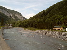
TheBregenzer Ach(also:Bregenzer Ache) is the mainriverof theBregenz Forest(Bregenzerwald) in theAustrian stateofVorarlberg.It is a tributary toLake Constanceand the RiverRhine,respectively.


Geography[edit]
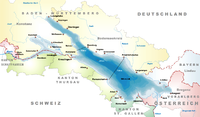
The source of the river is above the town ofSchröcken,at analtitudeof about 2,400 m (7,900 ft).[2]The river is 67 km (42 mi) long and drains almost the entire area of the Bregenz Forest. Its mouth onUpper Lake Constance(Obersee) is nearBregenzand lies east of the outflows of the riversDornbirner AchandAlpine Rhine.The outflow of Lake Constance is theHigh Rhine.
See also[edit]
References[edit]
- ^abComplete table of the Bavarian Waterbody Registerby the Bavarian State Office for the Environment (xls, 10.3 MB)
- ^"Bregenzer Ach in Österreich, Vorarlberg - alpen-guide.de".www.alpen-guide.de.Retrieved2 March2022.
Wikimedia Commons has media related toBregenzer Ache.


