
Brick Lane
51°31′19″N0°4′18″W/ 51.52194°N 0.07167°W

Brick Lane(Bengali:ব্রিক লেন,romanized:Brik Len) is a famous street in theEast End of London,in theborough of Tower Hamlets.It runs from Swanfield Street inBethnal Greenin the north, crosses the Bethnal Green Road before reaching the busiest, most commercially active part which runs throughSpitalfields,or along its eastern edge. Brick Lane's southern end is connected toWhitechapel High Streetby a short extension calledOsborn Street.
Today, it is the heart of the country'sBangladeshi communitywith the vicinity known to some asBanglatown.[1]It is famous for its manycurryrestaurants. The area surrounding Brick Lane and Spitalfields was branded as Banglatown in 1997, and the electoral ward of Spitalfields was changed to Banglatown & Spitalfields in 2002.
History
[edit]
15th to 18th centuries
[edit]The street was formerly known as Whitechapel Lane, and wound through fields. It derives its current name from brick and tile manufacture started in the 15th century, which used the localbrick earthdeposits.[2]The street featured in the 16th-centuryWoodcut map of Londonas a partially developed crossroad leading north from the city's most easterly edge, and by the 17th century was being developed northwards from the Barres (nowWhitechapel High Street) as a result of expanding population.[3]
Brewing came to Brick Lane before 1680, with water drawn from deep wells.[4]One brewer was Joseph Truman, first recorded in 1683. His family, particularlyBenjamin Truman,went on to establish the sizeableBlack Eagle Breweryon Brick Lane.[5]TheBrick Lane Marketfirst developed in the 17th century for fruit and vegetables sold outside the City.
Successive waves of immigrants settled in the area. In the 17th century, FrenchHuguenotsexpanded into the area for housing; the master weavers were based inSpitalfields.[6]Starting with the Huguenots, the area became a centre for weaving, tailoring and the developing clothing industry. It continued to attract immigrants, who provided semi-skilled and unskilled labour.
19th-century markets and their modern use
[edit]
In the 19th century,Irish people[7]andAshkenazi Jewsimmigrated to the area.[8]Jewish immigration continued into the early 20th century.
The Sunday market, like those onPetticoat Laneand nearbyColumbia Road,dates from a dispensation given by the government to the Jewish community in the 19th century. At the time, owing to the Christian observance of Sunday rest, no Sunday markets were open. Located at the junction ofCheshire Streetand Sclater Street, the market sellsbric-a-bracas well as fruit, vegetables and many other items.
In 2015 it was identified by police as the focal point of a trade in stolenbicyclesand bicycle parts, many taken from people employed in theCity of Londonwho had used "cycle to work" schemes. Alongside seven arrests, the police also warned purchasers that buying bicycles or parts in deals "too good to be true" could make them guilty ofhandling stolen goods.[9]Near the junction withHanbury Streetare two indoor markets; Upmarket and Backyard Market. The Brick Lane Farmers' Market opened in 2010, intended to be held every Sunday in nearby Bacon Street;[10]it has now closed.[11]
In the later 20th century,Bangladeshi BengalisfromSylhetcomprised the major group of immigrants and gradually predominated in the area.[12]Many Bengali immigrants to Brick Lane were from theGreater Sylhetregion of what becameBangladesh.These settlers helped shape Bangladeshi migration to Britain; many families fromBeanibazar,JagannathpurandBishwanathtend to live in the Brick Lane area though they spread around the London city.[13]
Religious groups
[edit]In 1742,La Neuve Eglise,a Huguenot chapel, was built on the corner of Brick Lane andFournier Street.By 1809, it was used by Wesleyan missionaries as The Jews' Chapel, where they promotedChristianityto the expandingJewishpopulation. It was adapted as aMethodistchapel in 1819 for Protestant residents. (John Wesleyhad preached his first "covenant sermon" at the nearbyBlack Eagle Street Chapel).
Reflecting the changing demographics of the area, in 1898, the building was consecrated as theMachzikei HaDath,or Spitalfields GreatSynagogue.After decades of change in the area, with Jews moving out and Bangladeshis moving in, in 1976 it was adapted again as the London Jamme Masjid (Great London Mosque) to serve the expandingBangladeshi community.[14]The building isGrade II* listed.[15]
Bengali settlement
[edit]

In the 20th century the Brick Lane area was important in the second wave of development ofAnglo-Indian cuisine,as families from countries such as Bangladesh (mainly theGreater Sylhetregion) migrated to London to look for work. Somecurryhouses of Brick Lane do not sellalcoholicbeverages, for most are owned byMuslims.According toEasyJet Traveller magazine,[16]the top three curry houses on Brick Lane in 2021 are Aladin, Sheba and City Spice.
Bengalis in the United Kingdom settled in big cities with industrial employment. In London, many settled in the East End. For centuries the East End has been the first port of call for many immigrants working in the docks and shipping fromChittagongport inBengal(theBritish Empire in Indiawas founded and based in Bengal). Their regular stopover paved the way for food outlets to be opened; these catered at first for an all-male workforce, for family migration and settlement took place some decades later. Humble beginnings such as this gave rise to Brick Lane as the famous curry capital of the UK (alongsideBirmingham'sBalti Triangle).
Designed by Meena Thakor, the ornamental Brick Lane Arch was erected in 1997 near Osborn Street to mark the entrance to Brick Lane and to 'Banglatown'. Like Brick Lane's lamp posts, the arch displays the red and green colours of the Bangladesh flag.[17]Having contributed so significantly to the area, the Bengali community campaigned to get the arch installed to celebrate Bengali culture in Brick Lane.[18]
Regeneration
[edit]
More recently the area has also broadened to being a vibrant art and fashion student area, with considerable exhibition space. Each year most of the fine art and fashion courses exhibit their work near Brick Lane.
Since the late 1990s, Brick Lane has been the site of several of the city's best knownnight clubs,notably 93 Feet East andThe Vibe Bar,both built on the site of TheOld Truman Brewery,once the industrial centre of the area, and now an office and entertainment complex. In 1999, it was the scene of abombing that injured 13 people.
Brick Lane has a regular display of graffiti, which features artists such asBanksy,Stik,ROA,D*Face,Ben EineandOmar Hassan.[19]The street has been used in many music videos, including "Glory Days"byJust Jack,"All These Things That I've Done"byThe Killers,and "Überlin"byR.E.M.[20]In 2023, some Chinese students painted the political slogan of theChinese Communist Party,"Core Socialist Values",in Chinese, sparking significant controversy.[21][22]
Land ownership and naming
[edit]
Large swathes of Brick Lane and its surrounding areas were once owned by theOsborne (later Osborn after 1720) family, Baronets, of Chicksands in the County of Bedford.The family's holdings survived until at least the 1970s. The family's history continues to be reflected by the naming of streets in the area around Brick Lane, including:
- Chicksand Streetreflects the village of Chicksands in Bedfordshire, location of the family seatChicksands Priory;
- The west end of what is now Chicksand Street was onceOsborn Place(see 1787 map);
- ModernOsborn Streetis a renaming of what was once the southernmost stretch of Brick Lane (seeRocque map of 1746for this naming, altered by the time of the 1787 map);
- Heneage Streetreflects the marriage of George Osborn, 4th Baronet, to Lady Heneage Finch (his 2nd wife) in April 1772;[23]
- The modern Hopetown Street was originallyFinch Street,reflecting the same marriage (see 1853 map, right);
- The modern Old Montague Street was originally justMontague Street,preserving the maternal family name of George Osborn, 4th Baronet, whose mother, Mary Montague, was the daughter of George Montague, 2nd Earl of Halifax.[23]The continuation of Chicksand Street to the east (now demolished) was onceHalifax Street,referencing the same marriage;
- Modern Hanbury Street is made up of four streets shown on the 1853 map: Browns Lane,Montague Street(triggering the addition of 'Old' to the earlier street of the same name), Well Street and Church Street.
-
-
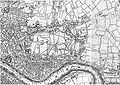
 Map, publisher unknown, dated 1787, showing Spitalfields ( "Spittlefields" ) and its environs
 -
 An extract from Cross's New Plan Of London, showing Stepney and surrounding areas. Published 1853 by J. Cross of London.


Buildings of interest
[edit]Nearby buildings of interest includeChrist Church, Spitalfields,the Jamme Masjid orGreat London Mosqueon the corner of Fournier Street (the building represents a history of successive communities of immigrants in East End), andThe Rag Factoryon Heneage Street (once home toTurner PrizenomineesTracey EminandGary Hume,now a thriving arts space).
Transport
[edit]
The nearestLondon Underground stationsareAldgate EastandLiverpool Street.A campaign was launched in 2006 to change the name of Aldgate East station to "Brick Lane",[24]but received no official support.
The nearestLondon Overgroundstation isShoreditch High Street station.This line runs on part of the formerEast London Linewhich has now been converted to London Overground. At the junction with Pedley Street existed the formerShoreditch Underground stationterminus, which closed in 2006 due to the construction of theEast London Line extension,and replaced by the aforementioned Shoreditch High Street. Remnants of the station can be seen from overground trains entering and leavingLiverpool Street station.
In popular culture
[edit]
The street is the location forMonica Ali's bookBrick Lane,published in 2003, and the film of thesame nameof 2007 starringTannishtha Chatterjee.The novel provoked a controversy with some of the local South Asian community because of a perceived negative portrayal of them. Parts of the Bengali community were particularly opposed to plans by Ruby Films to film parts of the movie based on the novel in the Brick Lane area and formed the "Campaign Against Monica Ali's Film Brick Lane". Consequently, the producers of the film used different locations for certain scenes, such as that depicting Brick Lane Market. Despite this, the director of the film,Sarah Gavron,attests on the DVD commentary of the film that genuine footage of Brick Lane does appear in the finished movie. Activists toldThe Guardianthey intended to burn copies of Ali's book during a rally to be held on 30 July 2006, but the demonstration passed without incident.[25]
Other notable books on the area areSalaam Brick LanebyTarquin Hall,[26]On Brick Lane(2007) byRachel LichtensteinandAn Acre of Barren Groundby Jeremy Gavron.[27]A large collection of photographs of the characters and salespeople who worked on the markets in Brick Lane were taken by Fran May between 1976 and 1978, whilst she was a student of photography at theRoyal College of Art.[28]
The street was used for several filming locations for the third season of the BBC television seriesLuther(2013).[citation needed]
See also
[edit]- Beigel Bake
- British Bangladeshi
- Green Street, London
- Balti Triangle,Birmingham, also known as 'The Halal Quarter'
References
[edit]- ^Spitalfields and Banglatown(London Borough of Tower Hamlets)Archived25 October 2007 at theWayback Machineaccessed 1 November 2007
- ^"Stepney: Economic History",A History of the County of Middlesex,Volume 11: Stepney, Bethnal Green (1998), pp. 52-63Retrieved 15 October 2007
- ^"Bethnal Green: The West: Shoreditch Side, Spitalfields, and the Nichol",A History of the County of Middlesex,Volume 11: Stepney, Bethnal Green (1998), pp. 103-109Retrieved 15 October 2007.
- ^Robert Bard.Whitechapel & Stepney Through Time.Stroud: Amberley Publishing, 2014. Retrieved 30 January 2018.
- ^The Black Eagle Brewery, Brick Lane,Survey of London:volume 27:Spitalfields and Mile End New Town(1957), pp. 116-122Retrieved 15 October 2007.
- ^"Bethnal Green: Settlement and Building to 1836",A History of the County of Middlesex,Volume 11: Stepney, Bethnal Green (1998), pp. 91-5Date Retrieved 17 April 2007
- ^John A. Jackson,The Irish in Britain,137-9, 150 (Routledge & Kegan Paul, 1964)
- ^"The Jews",A History of the County of Middlesex,Volume 1: Physique, Archaeology, Domesday, Ecclesiastical Organization, The Jews, Religious Houses, Education of Working Classes to 1870, Private Education from Sixteenth Century (1969), pp. 149-51Date Retrieved 17 April 2007
- ^Watts, Matt (18 May 2015). "Seven held at market as police target 'heart' of stolen bike trade".London Evening Standard.p. 18.
- ^'Brick Lane Farmers Market Opens',LFM
- ^"London Farmers' Markets | Brick Lane Farmers' Market".
- ^The Spatial Form of Bangladeshi Community in London's East EndIza Aftab (UCL)Archived27 February 2008 at theWayback Machine(particularly background of Bangladeshi immigration to the East End). Date Retrieved 17 April 2007
- ^Michael Smith, John Eade(2008).Transnational Ties: Cities, Migrations, and Identities.Transaction Publishers. pp. 148-149.
- ^Lucy Dixon, "A brief history of the Mosque"Archived28 August 2007 at theWayback Machine,My Tower Hamlets website, Retrieved 15 October 2007
- ^Historic England."Brick Lane Jamme Masjid (former Neuve Eglise) (1240697)".National Heritage List for England.Retrieved14 April2009.
- ^"London's Brick Lane: an insider's guide".EasyJet | Traveller.Retrieved3 November2021.
- ^"Bengali Cultural Walk"(PDF).Tower Hamlets Local History Library and Archives.Archived(PDF)from the original on 5 January 2018.
- ^"Spitalfields Neighbourhood Plan 2020-2035"(PDF).Tower Hamlets Council.
- ^"Bringing Colour to the Block".Hookedblog — UK Street Art.Retrieved21 March2016.
- ^"Please put the camera away, darling".Independent.co.uk.7 March 2011.
- ^"Brick Lane: Chinese political slogans appear on London street art wall".BBC News.7 August 2023.Retrieved8 August2023.
- ^Kottasová, Ivana; Gan, Nectar (8 August 2023)."Chinese propaganda slogans turn London street art wall into a protest site against Beijing]".CNN.Retrieved8 August2023.
- ^abCokayne (compiler), G.E. (1904).The Complete Baronetage, Volume 3.Exeter, UK: William Pollard & Co Ltd. pp. 243–44.
- ^"Bid to name Tube stop Brick Lane".BBC News.15 December 2006.Retrieved10 January2007.
- ^Cacciottolo, Mario."Brick Lane protesters hurt over 'lies'",BBC News, 31 July 2006.
- ^"Interview: author Tarquin Hall - Brick Lane".Icons of England.Archived fromthe originalon 2 November 2007.
- ^Myerson, Julie (1 April 2005)."Review: An Acre of Barren Ground by Jeremy Gavron".The Guardian.Archivedfrom the original on 13 April 2023.
- ^"Fran May Gallery".franmay.com.Archived fromthe originalon 4 December 2018.
External links
[edit]- Brick Laneentry at theSurvey of London(1957)
- Brick Lane through the last two hundred years,including many genealogical pubs.
- Virtual e-Tour Brick Lane
- Our Brick Lane - Eastside Community Heritage

