
Brooklyner
| The Brooklyner | |
|---|---|
 | |
 | |
| General information | |
| Status | Completed |
| Location | 111 Lawrence Street,Brooklyn,New York11201 United States |
| Coordinates | 40°41′33.7″N73°59′9.7″W/ 40.692694°N 73.986028°W |
| Construction started | 2008 |
| Completed | 2010 |
| Opening | 2010 |
| Management | Equity Residential |
| Height | |
| Roof | 531.5 ft (162.0 m) |
| Technical details | |
| Floor count | 51 |
| Floor area | 42,905 m2(461,830 sq ft) |
| Design and construction | |
| Architect(s) | GKV Architects |
| Developer | Clarett Group |
| Structural engineer | WSP Cantor Seinuk,Langan Engineering |
| Main contractor | Bovis Lend Lease[1] |
TheBrooklyneris askyscraperat 111 Lawrence Street inDowntown Brooklyn,New York City.Built by the Clarett Group and designed by GKV Architects, with WSP Cantor Seinuk (Structural Engineers), and Langan Engineering (Geotechnical Engineers), it became thetallest buildinginBrooklyn,surpassing theWilliamsburgh Savings Bank Towerin 2010. Later, in 2014, the Brooklyner was surpassed by388 Bridge Streetfor the tallest skyscraper in the borough.
The structure contains 491 rental units and is currently managed byEquity Residential.The building is 51 stories tall and 531.5 feet (162.0 meters) in height.[2]
Gallery
[edit]-
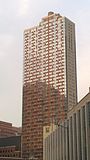 Front façade of building looking northeast from Red Hook Lane.
 -
 Rear concrete façade of building looking west.
 -
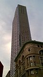 Side exterior shot looking north on Lawrence street.


See also
[edit]References
[edit]- ^"The Brooklyner".CTBUH.com.RetrievedSeptember 22,2016.
- ^"The Brooklyner".SkyscraperPage.com.RetrievedOctober 19,2010.
External links
[edit]- Official website
- The Brooklynerat GKV Architects
- The BrooklyneronCTBUH
- The Brooklyner[usurped]onEmporis
- The Brooklyneron theSkyscraperpage.com
This article about a building or structure inBrooklynis astub.You can help Wikipedia byexpanding it. |
Categories:
- Residential buildings in Brooklyn
- Residential skyscrapers in New York City
- Residential buildings completed in 2010
- Downtown Brooklyn
- 2010s architecture in the United States
- 2010 establishments in New York City
- Condominiums and housing cooperatives in Brooklyn
- Postmodern architecture
- Skyscrapers in Brooklyn
- Brooklyn building and structure stubs