Camagüey Province
Camagüey Province
Provincia de Camagüey | |
|---|---|
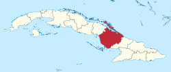
 Camagüey Province located in the Map of Cuba | |
| Country | Cuba |
| Capital | Camagüey |
| Subdivisions | 16 municipalities |
| Government | |
| • Type | Mayor-council government |
| Area | |
| •Province | 15,413.82 km2(5,951.31 sq mi) |
| Population (2021)[1] | |
| •Province | 1,630,253 |
| • Density | 110/km2(270/sq mi) |
| •Urban | 1,038,389 |
| Demonym | Camagüeyans |
| Time zone | UTC-5(EST) |
| Area code | +53-32 |
| HDI(2019) | 0.760[2] high·14th of 16 |
| Website | Portal Camagüey |
Camagüey(Spanish pronunciation:[kamaˈ(ɣ)wej]) is the largest of theprovinces of Cuba.Its capital isCamagüey.Other towns includeFloridaandNuevitas.
Geography
[edit]Camagüey is mostly low lying, with no major hills ormountain rangespassing through the province. Numerous largecays(including what used to be one ofFidel Castro's favouritefishingspots; theArchipiélago Jardines de la Reina) characterize the southerncoasts,while the northern coast is lined byJardines del Reyof theSabana-Camagüey Archipelago.
Sandybeachesare found on both coasts also, and despite a large potential fortourism,the province has seen little development in that area with the exception of Santa Lucía beach, on the province's North coast.
Economy
[edit]The economy of the Camagüey province is primarilycattleandsugar(in the north and south)farming,and the province is known for itscowboyculture, withrodeosfrequently held.Chickensandriceare also farmed, and a smallcitrus fruitindustry exists. The capital city also has one of the few breweries on the island.
Municipalities
[edit]| Municipality | Population (2022) |
Area (km2) |
Location | Remarks |
|---|---|---|---|---|
| Camagüey | 333,251 | 1,106 | 21°23′2″N77°54′26″W/ 21.38389°N 77.90722°W | Provincial capital |
| Carlos M. de Céspedes | 22,842 | 653 | 21°34′37″N78°16′39″W/ 21.57694°N 78.27750°W | |
| Esmeralda | 29,203 | 1,480 | 21°51′22″N78°06′40″W/ 21.85611°N 78.11111°W | |
| Florida | 69,174 | 1,800 | 21°31′46″N78°13′21″W/ 21.52944°N 78.22250°W | |
| Guáimaro | 36,114 | 1,847 | 21°03′32″N77°20′52″W/ 21.05889°N 77.34778°W | |
| Jimaguayú | 19,687 | 799 | 21°16′0″N77°49′49″W/ 21.26667°N 77.83028°W | |
| Minas | 35,966 | 1,015 | 21°29′22″N77°36′17″W/ 21.48944°N 77.60472°W | |
| Najasa | 14,732 | 921 | 21°05′2″N77°44′49″W/ 21.08389°N 77.74694°W | |
| Nuevitas | 59,483 | 415 | 21°32′25″N77°15′52″W/ 21.54028°N 77.26444°W | |
| Santa Cruz del Sur | 39,919 | 1,122 | 20°43′10″N77°59′27″W/ 20.71944°N 77.99083°W | |
| Sibanicú | 28,930 | 736 | 21°14′21″N77°31′15″W/ 21.23917°N 77.52083°W | |
| Sierra de Cubitas | 17,942 | 549 | 21°43′59″N77°46′14″W/ 21.73306°N 77.77056°W | |
| Vertientes | 48,821 | 2,005 | 21°15′26″N78°08′56″W/ 21.25722°N 78.14889°W |
References
[edit]- ^ab"Lugar que ocupa el territorio según la superficie y la población"(PDF).Una MIRADA a Cuba(in Spanish). Oficina Nacional de Estadísticas. Cuba. 2010.
- ^"Sub-national HDI - Area Database - Global Data Lab".hdi.globaldatalab.org.Retrieved2022-01-24.
- ^"Camagüey (Province, Cuba) - Population Statistics, Charts, Map and Location".City Population.Retrieved2024-02-03.
- ^Statoids (July 2003)."Municipios of Cuba".Retrieved2007-10-06.
Further reading
[edit]- New York Public Library(1912)."Cuba: History and Description: Special Places: Puerto Principe (Province)".List of Works Relating to the West Indies.
External links
[edit]- (in Spanish)Portal CamagüeyArchived2007-03-13 at theWayback Machine

