
Canal


Canalsorartificial waterwaysarewaterwaysorengineeredchannelsbuilt fordrainagemanagement (e.g.flood controlandirrigation) or for conveyancingwater transportvehicles(e.g.water taxi). They carry free, calm surface flow underatmospheric pressure,and can be thought of as artificialrivers.
In most cases, a canal has a series ofdamsandlocksthat createreservoirsof low speed current flow. These reservoirs are referred to asslack water levels,often just calledlevels.A canal can be called anavigation canalwhen it parallels a natural river and shares part of the latter'sdischargesanddrainage basin,and leverages its resources by building dams and locks to increase and lengthen its stretches of slack water levels while staying in itsvalley.
A canal can cut across adrainage divideatop aridge,generally requiring an external water source above the highestelevation.The best-known example of such a canal is thePanama Canal.
Many canals have been built at elevations, above valleys and other waterways. Canals with sources of water at a higher level can deliver water to a destination such as a city where water is needed. TheRoman Empire'saqueductswere suchwater supplycanals.
The term was once used to describe linear features seen on the surface ofMars,Martian canals,an optical illusion.
Types of artificial waterways[edit]

Anavigationis a series of channels that run roughly parallel to the valley andstream bedof an unimproved river. A navigation always shares thedrainage basinof the river. A vessel uses the calm parts of the river itself as well as improvements, traversing the same changes in height.
A truecanalis a channel that cuts across adrainage divide,making a navigable channel connecting two differentdrainage basins.

Structures used in artificial waterways[edit]
Both navigations and canals useengineeredstructures to improve navigation:
- weirsanddamsto raise river water levels to usable depths;
- looping descents to create a longer and gentler channel around a stretch of rapids or falls;
- locksto allow ships and barges to ascend/descend.
Since they cut across drainage divides, canals are more difficult to construct and often need additional improvements, likeviaductsandaqueductsto bridge waters over streams and roads, and ways to keep water in the channel.
Types of canals[edit]
There are two broad types of canal:
- Waterways:canals and navigations used for carrying vessels transporting goods and people. These can be subdivided into two kinds:
- Aqueducts:water supplycanals that are used for the conveyance and delivery ofpotablewater,municipaluses, hydropower canalsandagricultureirrigation.


Importance[edit]
Historically, canals were of immense importance to commerce and the development, growth and vitality of a civilization. In 1855 theLehigh Canalcarried over 1.2 million tons of anthracite coal; by the 1930s the company which built and operated it for over a century ceased operation. The few canals still in operation in our modern age are a fraction of the numbers that once fueled and enabled economic growth, indeed were practically a prerequisite to further urbanization and industrialization. For the movement of bulk raw materials such as coal and ores are difficult and marginally affordable without water transport. Such raw materials fueled the industrial developments and newmetallurgyresulting of the spiral of increasing mechanization during 17th–20th century, leading to new research disciplines, new industries and economies of scale, raising the standard of living for any industrialized society.
The surviving canals[edit]
Mostship canalstoday primarily servicebulk cargoand largeship transportationindustries, whereas the once critical smaller inland waterways conceived and engineered as boat and barge canals have largely been supplanted and filled in, abandoned and left to deteriorate, or kept in service and staffed by state employees, where dams and locks are maintained for flood control or pleasure boating. Their replacement was gradual, beginning first in the United States in the mid-1850s where canal shipping was first augmented by, then began being replaced by usingmuch faster,less geographically constrained & limited, and generally cheaper to maintainrailways.
By the early 1880s, canals which had little ability to economically compete with rail transport, were off the map. In the next couple of decades, coal was increasingly diminished as the heating fuel of choice by oil, and growth of coal shipments leveled off. Later, afterWorld War Iwhen motor-trucks came into their own, the last small U.S. barge canals saw a steady decline in cargo ton-miles alongside many railways, the flexibility and steep slope climbing capability of lorries taking over cargo hauling increasingly as road networks were improved, and which also had the freedom to make deliveries well away from rail lined road beds orditchesin the dirt which could not operate in the winter.
The longest extant canal today, theGrand Canalin northern China, still remains in heavy use, especially the portion south of theYellow River.It stretches fromBeijingtoHangzhouat 1,794 kilometres (1,115 miles).
Construction[edit]
Canals are built in one of three ways, or a combination of the three, depending on available water and available path:
- Human made streams
- A canal can be created where no stream presently exists. Either the body of the canal is dug or the sides of the canal are created by makingdykes or leveesby piling dirt, stone, concrete or other building materials. The finished shape of the canal as seen in cross section is known as thecanal prism.[1]The water for the canal must be provided from an external source, like streams or reservoirs. Where the new waterway must change elevation engineering works like locks, lifts or elevators are constructed to raise and lower vessels. Examples include canals that connect valleys over a higher body of land, likeCanal du Midi,Canal de Briareand thePanama Canal.
- A canal can be constructed by dredging a channel in the bottom of an existing lake. When the channel is complete, the lake is drained and the channel becomes a new canal, serving both drainage of the surroundingpolderand providing transport there. Examples include theLage Vaart.One can also build two parallel dikes in an existing lake, forming the new canal in between, and then drain the remaining parts of the lake. The eastern and central parts of theNorth Sea Canalwere constructed in this way. In both cases pumping stations are required to keep the land surrounding the canal dry, either pumping water from the canal into surrounding waters, or pumping it from the land into the canal.
- Canalization and navigations
- A stream can becanalizedto make its navigable path more predictable and easier to maneuver. Canalization modifies the stream to carry traffic more safely by controlling the flow of the stream by dredging, damming and modifying its path. This frequently includes the incorporation of locks and spillways, that make the river a navigation. Examples include theLehigh CanalinNortheastern Pennsylvania'scoal Region,Basse Saône,Canal de Mines de Fer de la Moselle,and canalAisne.Riparian zone restorationmay be required.
- Lateral canals
- When a stream is too difficult to modify withcanalization,a second stream can be created next to or at least near the existing stream. This is called alateral canal,and may meander in a large horseshoe bend or series of curves some distance from the source waters stream bed lengthening the effective length in order to lower the ratio of rise over run (slope or pitch). The existing stream usually acts as the water source and the landscape around its banks provide a path for the new body. Examples include theChesapeake and Ohio Canal,Canal latéral à la Loire,Garonne Lateral Canal,Welland CanalandJuliana Canal.
Smaller transportation canals can carrybargesornarrowboats,whileship canalsallow seagoing ships to travel to an inland port (e.g.,Manchester Ship Canal), or from one sea or ocean to another (e.g.,Caledonian Canal,Panama Canal).
Features[edit]
At their simplest, canals consist of a trench filled with water. Depending on thestratumthe canal passes through, it may be necessary tolinethe cut with some form of watertight material such as clay or concrete. When this is done with clay, it is known aspuddling.
Canals need to be level, and while small irregularities in the lie of the land can be dealt with through cuttings and embankments, for larger deviations other approaches have been adopted. The most common is thepound lock,which consists of a chamber within which the water level can be raised or lowered connecting either two pieces of canal at a different level or the canal with a river or the sea. When there is a hill to be climbed, flights of many locks in short succession may be used.
Prior to the development of the pound lock in 984 AD in China by Chhaio Wei-Yo[2]and later in Europe in the 15th century, eitherflash locksconsisting of a single gate were used or ramps, sometimes equipped with rollers, were used to change the level. Flash locks were only practical where there was plenty of water available.
Locks use a lot of water, so builders have adopted other approaches for situations where little water is available. These includeboat lifts,such as theFalkirk Wheel,which use acaissonof water in which boats float while being moved between two levels; andinclined planeswhere a caisson is hauled up a steep railway.
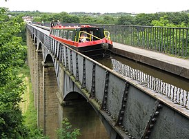
To cross a stream, road or valley (where the delay caused by a flight of locks at either side would be unacceptable) the valley can be spanned by anavigable aqueduct– a famous example in Wales is thePontcysyllte Aqueduct(now aUNESCOWorld Heritage Site) across the valley of theRiver Dee.
Another option for dealing with hills is to tunnel through them. An example of this approach is theHarecastle Tunnelon theTrent and Mersey Canal.Tunnels are only practical for smaller canals.
Some canals attempted to keep changes in level down to a minimum. These canals known ascontour canalswould take longer, winding routes, along which the land was a uniform altitude. Other, generally later, canals took more direct routes requiring the use of various methods to deal with the change in level.
Canals have various features to tackle the problem of water supply. In cases, like the Suez Canal, the canal is open to the sea. Where the canal is not at sea level, a number of approaches have been adopted. Taking water from existing rivers or springs was an option in some cases, sometimes supplemented by other methods to deal with seasonal variations in flow. Where such sources were unavailable,reservoirs– either separate from the canal or built into its course – andback pumpingwere used to provide the required water. In other cases, water pumped from mines was used to feed the canal. In certain cases, extensive "feeder canals" were built to bring water from sources located far from the canal.
Where large amounts of goods are loaded or unloaded such as at the end of a canal, acanal basinmay be built. This would normally be a section of water wider than the general canal. In some cases, the canal basins containwharfsand cranes to assist with movement of goods.
When a section of the canal needs to be sealed off so it can be drained for maintenancestop planksare frequently used. These consist of planks of wood placed across the canal to form a dam. They are generally placed in pre-existing grooves in the canal bank. On more modern canals, "guard locks" or gates were sometimes placed to allow a section of the canal to be quickly closed off, either for maintenance, or to prevent a major loss of water due to a canal breach.
Canal falls[edit]
Acanal fall,or canal drop, is a vertical drop in the canal bed. These are built when the natural ground slope is steeper than the desired canal gradient. They are constructed so the falling water's kinetic energy is dissipated in order to prevent it fromscouringthe bed and sides of the canal.[3]: 643
A canal fall is constructed bycut and fill.It may be combined with a regulator, bridge, or other structure to save costs.[3]: 643–4
There are various types of canal falls, based on their shape. One type is theogeefall, where the drop follows an s-shaped curve to create a smooth transition and reduceturbulence.However, this smooth transition does not dissipate the water's kinetic energy, which leads to heavy scouring. As a result, the canal needs to be reinforced with concrete or masonry to protect it from eroding.[3]: 644
Another type of canal fall is the vertical fall, which is "simple and economical". These feature a "cistern", or depressed area just downstream from the fall, to "cushion" the water by providing a deep pool for its kinetic energy to bediffusedin. Vertical falls work for drops of up to 1.5 m in height, and for discharge of up to 15 cubic meters per second.[3]: 646
-

-
-
 TheCorinth Canalseen from the air
 -
 Miami and Erie Canal Lock in Ohio, United States


History[edit]

The transport capacity ofpack animalsandcartsis limited. A mule can carry an eighth-ton[4][250 pounds (113 kg)] maximum load over a journey measured in days and weeks,[4]though much more for shorter distances and periods with appropriate rest.[4]Besides, carts need roads. Transport over water is much more efficient and cost-effective for large cargoes.
Ancient canals[edit]
The oldest known canals wereirrigationcanals, built inMesopotamiac. 4000 BC,in what is nowIraq.TheIndus Valley civilizationofancient India(c. 3000 BC) had sophisticated irrigation and storage systems developed, including thereservoirsbuilt atGirnarin 3000 BC.[5]This is the first time that such planned civil project had taken place in the ancient world. InEgypt,canals date back at least to the time ofPepi I Meryre(reigned 2332–2283 BC), who ordered a canal built to bypass thecataracton the Nile nearAswan.[6]

Inancient China,large canals for river transport were established as far back as theSpring and Autumn Period(8th–5th centuries BC), the longest one of that period being the Hong Gou (Canal of the Wild Geese), which according to the ancient historianSima Qianconnected the old states of Song, Zhang, Chen, Cai, Cao, and Wei.[7]TheCaoyun Systemof canals was essential for imperial taxation, which was largely assessed in kind and involved enormous shipments of rice and other grains. By far the longest canal was theGrand Canal of China,still the longest canal in the world today and the oldest extant one.[8]It is 1,794 kilometres (1,115 mi) long and was built to carry theEmperor Yang Guangbetween Zhuodu (Beijing) and Yuhang (Hangzhou). The project began in 605 and was completed in 609, although much of the work combined older canals, the oldest section of the canal existing since at least 486 BC. Even in its narrowest urban sections it is rarely less than 30 metres (98 ft) wide.
In the 5th century BC,AchaemenidkingXerxes Iof Persia ordered the construction of theXerxes Canalthrough the base ofMount Athospeninsula,Chalkidiki,northern Greece.[9]It was constructed as part of his preparations for theSecond Persian invasion of Greece,a part of theGreco-Persian Wars.It is one of the few monuments left by the Persian Empire inEurope.[10]
Greek engineerswere also among the first to usecanal locks,by which they regulated the water flow in theAncient Suez Canalas early as the 3rd century BC.[11][12][13]
There was little experience moving bulk loads by carts, while a pack-horse would [i.e. 'could'] carry only an eighth of a ton. On a soft road a horse might be able to draw 5/8ths of a ton. But if the load were carried by a barge on a waterway, then up to 30 tons could be drawn by the same horse.
— technology historianRonald W. Clarkreferring to transport realities before the industrial revolution and theCanal age.[4]
Hohokamwas a society in theNorth American Southwestin what is now part ofArizona,United States, andSonora,Mexico. Their irrigation systems supported the largest population in the Southwest by 1300 CE.[14]Archaeologists working at a major archaeological dig in the 1990s in the Tucson Basin, along the Santa Cruz River, identified a culture and people that may have been the ancestors of the Hohokam.[15]This prehistoric group occupied southern Arizona as early as 2000 BCE, and in the Early Agricultural Period grew corn, lived year-round in sedentary villages, and developed sophisticated irrigation canals.[14] The large-scale Hohokam irrigation network in thePhoenix metropolitan areawas the most complex in ancient North America. A portion of the ancient canals has been renovated for theSalt River Projectand now helps to supply the city's water.

TheSinhaleseconstructed the 87 km (54 mi)Yodha Elain 459 A.D. as a part of theirextensive irrigation networkwhich functioned in a way of a moving reservoir due to its single banking aspect to manage the canal pressure with the influx of water. It was also designed as an elongated reservoir passing through traps creating 66 mini catchments as it flows fromKala WewatoThissa Wawa.The canal was not designed for the quick conveying of water from Kala Wewa to Thissa Wawa but to create a mass of water between the two reservoirs, which would in turn provided for agriculture and the use of humans and animals.[16] [17]They also achieved a rather low gradient for its time. The canal is still in use after renovation.
Middle Ages[edit]

In theMiddle Ages,water transport was several times cheaper and faster than transport overland. Overland transport byanimal drawnconveyances was used around settled areas, but unimproved roads required pack animal trains, usually ofmulesto carry any degree of mass, and while a mule could carry an eighth ton,[4]it also needed teamsters to tend it and one man could only tend perhaps five mules,[4]meaning overlandbulk transportwas also expensive, as men expect compensation in the form of wages, room and board. This was because long-haul roads were unpaved, more often than not too narrow for carts, much less wagons, and in poor condition, wending their way through forests, marshy or muddy quagmires as often as unimproved but dry footing. In that era, as today, greater cargoes, especially bulk goods andraw materials,could be transported by ship far more economically than by land; in the pre-railroad days of the industrial revolution, water transport was the gold standard of fast transportation. The first artificial canal in Western Europe was theFossa Carolinabuilt at the end of the 8th century under personal supervision ofCharlemagne.
In Britain, theGlastonbury Canalis believed to be the first post-Roman canal and was built in the middle of the 10th century to link theRiver Brueat Northover[18]withGlastonbury Abbey,a distance of about 1.75 kilometres (1,900 yd).[19]Its initial purpose is believed to be the transport of building stone for the abbey, but later it was used for delivering produce, including grain, wine and fish, from the abbey's outlying properties. It remained in use until at least the 14th century, but possibly as late as the mid-16th century.[20]
More lasting and of more economic impact were canals like theNaviglio Grandebuilt between 1127 and 1257 to connectMilanwith the riverTicino.The Naviglio Grande is the most important of thelombard"navigli"[21]and the oldest functioning canal in Europe.
Later, canals were built in theNetherlandsandFlandersto drain thepoldersand assist transportation of goods and people.
Canal building was revived in this age because of commercial expansion from the 12th century. River navigations were improved progressively by the use of single, orflash locks.Taking boats through these used large amounts of water leading to conflicts withwatermillowners and to correct this, thepoundor chamber lock first appeared, in the 10th century in China and in Europe in 1373 inVreeswijk,Netherlands.[22]Another important development was themitre gate,which was, it is presumed, introduced in Italy by Bertola da Novate in the 16th century. This allowed wider gates and also removed the height restriction ofguillotine locks.
To break out of the limitations caused by river valleys, the firstsummit level canalswere developed with theGrand Canal of Chinain 581–617 AD whilst in Europe the first, also using single locks, was theStecknitz Canalin Germany in 1398.
Africa[edit]
In theSonghai Empireof West Africa, several canals were constructed underSunni AliandAskia Muhammad IbetweenKabaraandTimbuktuin the 15th century. These were used primarily for irrigation and transport. Sunni Ali also attempted to construct a canal from theNiger RivertoWalatato facilitate conquest of the city but his progress was halted when he went to war with theMossi Kingdoms.[23]
Early modern period[edit]

Around 1500–1800 the first summit level canal to use pound locks in Europe was theBriare Canalconnecting theLoireandSeine(1642), followed by the more ambitiousCanal du Midi(1683) connecting the Atlantic to the Mediterranean. This included a staircase of 8 locks atBéziers,a 157 metres (515 ft) tunnel, and three major aqueducts.
Canal building progressed steadily in Germany in the 17th and 18th centuries with three great rivers, theElbe,OderandWeserbeing linked by canals. In post-Roman Britain, the firstearly modern periodcanal built appears to have been theExeter Canal,which was surveyed in 1563, and open in 1566.[24][25]
The oldest canal in the European settlements of North America, technically amill racebuilt for industrial purposes, isMother Brookbetween theBoston, Massachusettsneighbourhoods ofDedhamandHyde Parkconnecting the higher waters of theCharles Riverand the mouth of theNeponset Riverand the sea. It was constructed in 1639 to provide water power for mills.
In Russia, theVolga–Baltic Waterway,a nationwide canal system connecting theBaltic SeaandCaspian Seavia theNevaandVolgarivers, was opened in 1718.
Industrial Revolution[edit]

The modern canal system was mainly a product of the 18th century and early 19th century. It came into being because theIndustrial Revolution(which began in Britain during the mid-18th century) demanded an economic and reliable way to transport goods and commodities in large quantities.
By the early 18th century, river navigations such as theAire and Calder Navigationwere becoming quite sophisticated, withpound locksand longer and longer "cuts" (some with intermediate locks) to avoid circuitous or difficult stretches of river. Eventually, the experience of building long multi-level cuts with their own locks gave rise to the idea of building a "pure" canal, a waterway designed on the basis of where goods needed to go, not where a river happened to be.
The claim for the first pure canal inGreat Britainis debated between "Sankey" and "Bridgewater" supporters.[26]The first true canal in what is now the United Kingdom was theNewry CanalinNorthern Irelandconstructed byThomas Steersin 1741.
TheSankey Brook Navigation,which connectedSt Helenswith theRiver Mersey,is often claimed as the first modern "purely artificial" canal because although originally a scheme to make the Sankey Brook navigable, it included an entirely new artificial channel that was effectively a canal along the Sankey Brook valley.[26][27]However, "Bridgewater" supporters point out that the last quarter-mile of the navigation is indeed a canalized stretch of the Brook, and that it was the Bridgewater Canal (less obviously associated with an existing river) that captured the popular imagination and inspired further canals.[26][27]

In the mid-eighteenth century the3rd Duke of Bridgewater,who owned a number ofcoal minesin northern England, wanted a reliable way to transport his coal to the rapidly industrializing city ofManchester.He commissioned the engineerJames Brindleyto build a canal for that purpose. Brindley's design included an aqueduct carrying the canal over theRiver Irwell.This was an engineering wonder which immediately attracted tourists.[26][27]The construction of this canal was funded entirely by the Duke and was called theBridgewater Canal.It opened in 1761 and was the first major British canal.[28]
The new canals proved highly successful. The boats on the canal were horse-drawn with atowpathalongside the canal for the horse to walk along. This horse-drawn system proved to be highly economical and became standard across the British canal network. Commercial horse-drawn canal boats could be seen on the UK's canals until as late as the 1950s, although by then diesel-powered boats, often towing a second unpowered boat, had become standard.
The canal boats could carry thirty tons at a time with only one horse pulling[28]– more than ten times the amount of cargo per horse that was possible with a cart. Because of this huge increase in supply, the Bridgewater canal reduced the price of coal in Manchester by nearly two-thirds within just a year of its opening. The Bridgewater was also a huge financial success, with it earning what had been spent on its construction within just a few years.
This success proved the viability of canal transport, and soon industrialists in many other parts of the country wanted canals. After the Bridgewater canal, early canals were built by groups of private individuals with an interest in improving communications. In Staffordshire the famous potterJosiah Wedgwoodsaw an opportunity to bring bulky cargoes of clay to his factory doors and to transport his fragile finished goods to market in Manchester,Birminghamor further away, by water, minimizing breakages. Within just a few years of the Bridgewater's opening, an embryonic national canal network came into being, with the construction of canals such as theOxford Canaland theTrent & Mersey Canal.[29]

The new canal system was both cause and effect of the rapid industrialization ofThe Midlandsand the north. The period between the 1770s and the 1830s is often referred to as the "Golden Age" of British canals.
For each canal, an Act of Parliament was necessary to authorize construction, and as people saw the high incomes achieved from canal tolls, canal proposals came to be put forward by investors interested in profiting from dividends, at least as much as by people whose businesses would profit from cheaper transport of raw materials and finished goods.
In a further development, there was often out-and-out speculation, where people would try to buy shares in a newly floated company to sell them on for an immediate profit, regardless of whether the canal was ever profitable, or even built. During this period of "canal mania",huge sums were invested in canal building, and although many schemes came to nothing, the canal system rapidly expanded to nearly 4,000 miles (over 6,400 kilometres) in length.[28]
Many rival canal companies were formed and competition was rampant. Perhaps the best example wasWorcester Barin Birmingham, a point where theWorcester and Birmingham Canaland theBirmingham Canal Navigations Main Linewere only seven feet apart. For many years, a dispute about tolls meant that goods travelling through Birmingham had to be portaged from boats in one canal to boats in the other.[30]

Canal companies were initially chartered by individual states in the United States. These early canals were constructed, owned, and operated by private joint-stock companies. Four were completed when theWar of 1812broke out; these were theSouth Hadley Canal(opened 1795) inMassachusetts,Santee Canal(opened 1800) inSouth Carolina,theMiddlesex Canal(opened 1802) also in Massachusetts, and theDismal Swamp Canal(opened 1805) inVirginia.TheErie Canal(opened 1825) was chartered and owned by the state ofNew Yorkand financed bybondsbought by private investors. The Erie canal runs about 363 miles (584 km) fromAlbany, New York,on theHudson RivertoBuffalo, New York,atLake Erie.The Hudson River connects Albany to the Atlantic port ofNew York Cityand the Erie Canal completed a navigable water route from theAtlantic Oceanto theGreat Lakes.The canal contains 36 locks and encompasses a total elevation differential of around 565 ft. (169 m). The Erie Canal with its easy connections to most of the U.S. mid-west and New York City soon quickly paid back all its invested capital (US$7 million) and started turning a profit. By cutting transportation costs in half or more it became a large profit center for Albany and New York City as it allowed the cheap transportation of many of the agricultural products grown in the mid west of the United States to the rest of the world. From New York City these agricultural products could easily be shipped to other U.S. states or overseas. Assured of a market for their farm products the settlement of the U.S. mid-west was greatly accelerated by the Erie Canal. The profits generated by the Erie Canal project started a canal building boom in the United States that lasted until about 1850 whenrailroadsstarted becoming seriously competitive in price and convenience. TheBlackstone Canal(finished in 1828) in Massachusetts andRhode Islandfulfilled a similar role in the early industrial revolution between 1828 and 1848. TheBlackstone Valleywas a major contributor of the American Industrial Revolution whereSamuel Slaterbuilt his first textile mill.

Power canals[edit]
Apower canalrefers to a canal used forhydraulic powergeneration, rather than for transport. Nowadays power canals are built almost exclusively as parts ofhydroelectric power stations.Parts of the United States, particularly in theNortheast,had enough fast-flowing rivers thatwater powerwas the primary means of powering factories (usually textile mills) until after theAmerican Civil War.For example,Lowell, Massachusetts,considered to be "The Cradle of the American Industrial Revolution," has 6 miles (9.7 km) of canals, built from around 1790 to 1850, that provided water power and a means of transportation for the city. The output of the system is estimated at 10,000horsepower.[31]Other cities with extensive power canal systems includeLawrence, Massachusetts,Holyoke, Massachusetts,Manchester, New Hampshire,andAugusta, Georgia.The most notable power canal was built in 1862 for theNiagara Falls Hydraulic Power and Manufacturing Company.
19th century[edit]

Competition, from railways from the 1830s and roads in the 20th century, made the smaller canals obsolete for most commercial transport, and many of the British canals fell into decay. Only theManchester Ship Canaland theAire and Calder Canalbucked this trend. Yet in other countries canals grew in size as construction techniques improved. During the 19th century in the US, the length of canals grew from 100 miles (161 km) to over 4,000, with a complex network making the Great Lakes navigable, in conjunction with Canada, although some canals were later drained and used as railroadrights-of-way.
In the United States, navigable canals reached into isolated areas and brought them in touch with the world beyond. By 1825 the Erie Canal, 363 miles (584 km) long with 36 locks, opened up a connection from the populated Northeast to the Great Lakes. Settlers flooded into regions serviced by such canals, since access to markets was available. The Erie Canal (as well as other canals) was instrumental in lowering the differences in commodity prices between these various markets across America. The canals caused price convergence between different regions because of their reduction in transportation costs, which allowed Americans to ship and buy goods from farther distances much cheaper. Ohio built many miles of canal, Indiana had working canals for a few decades, and theIllinois and Michigan Canalconnected the Great Lakes to theMississippi Riversystem until replaced by a channelized river waterway.

Three major canals with very different purposes were built in what is now Canada. The firstWelland Canal,which opened in 1829 betweenLake Ontarioand Lake Erie, bypassingNiagara Fallsand theLachine Canal(1825), which allowed ships to skirt the nearly impassable rapids on theSt. Lawrence RiveratMontreal,were built for commerce. TheRideau Canal,completed in 1832, connectsOttawaon theOttawa RivertoKingston, Ontarioon Lake Ontario. The Rideau Canal was built as a result of the War of 1812 to provide military transportation between the British colonies ofUpper CanadaandLower Canadaas an alternative to part of the St. Lawrence River, which was susceptible to blockade by the United States.

In France, a steady linking of all the river systems –Rhine,Rhône,Saôneand Seine – and the North Sea was boosted in 1879 by the establishment of theFreycinet gauge,which specified the minimum size of locks. Canal traffic doubled in the first decades of the 20th century.[32]
Many notable sea canals were completed in this period, starting with theSuez Canal(1869) – which carries tonnage many times that of most other canals – and theKiel Canal(1897), though the Panama Canal was not opened until 1914.
In the 19th century, a number of canals were built in Japan including theBiwako canaland theTone canal.These canals were partially built with the help of engineers from the Netherlands and other countries.[33]
A major question was how to connect the Atlantic and the Pacific with a canal through narrowCentral America.(ThePanama Railroadopened in 1855.) The original proposal was for asea-level canal through what is today Nicaragua,taking advantage of the relatively largeLake Nicaragua.This canal has never been built in part because of political instability,which scared off potential investors. It remains an active project (the geography has not changed), and in the 2010s Chinese involvement was developing.

The second choice for a Central American canal was aPanama Canal.TheDe Lessupscompany, which ran theSuez Canal,first attempted to build a Panama Canal in the 1880s. The difficulty of the terrain and weather (rain) encountered caused the company to go bankrupt. High worker mortality from disease also discouraged further investment in the project. DeLessup's abandonedexcavating equipmentsits, isolated decaying machines, today tourist attractions.
Twenty years later, an expansionist United States, that just acquired colonies after defeating Spain in the 1898Spanish–American War,and whose Navy became more important, decided to reactivate the project. The United States and Colombia did not reach agreement on the terms of a canal treaty (seeHay–Herrán Treaty). Panama, which did not have (and still does not have) a land connection with the rest of Colombia, was already thinking of independence. In 1903 the United States, with support from Panamanians who expected the canal to provide substantial wages, revenues, and markets for local goods and services,took Panama province away from Colombia,and set up apuppet republic(Panama). Its currency, theBalboa– a name that suggests the country began as a way to get from one hemisphere to the other – was a replica of theUS dollar.The US dollar was and remainslegal tender(used as currency). A U.S. military zone, theCanal Zone,10 miles (16 km) wide, with U.S. military stationed there (bases,2 TV stations, channels 8 and 10,Pxs,aU.S.-style high school), split Panama in half. The Canal – a major engineering project – was built. The U.S. did not feel that conditions were stable enough to withdraw until 1979. The withdrawal from Panama contributed to PresidentJimmy Carter's defeat in 1980.
Modern uses[edit]

Large-scale ship canals such as the Panama Canal and Suez Canal continue to operate for cargo transportation, as do European barge canals. Due toglobalization,they are becoming increasingly important, resulting in expansion projects such as thePanama Canal expansion project.The expanded canal began commercial operation on 26 June 2016. The new set of locks allow transit of larger,Post-PanamaxandNew Panamaxships.[34]
The narrow early industrial canals, however, have ceased to carry significant amounts of trade and many have been abandoned to navigation, but may still be used as a system for transportation of untreated water. In some cases railways have been built along the canal route, an example being theCroydon Canal.
A movement that began in Britain and France to use the early industrial canals for pleasure boats, such ashotel barges,has spurred rehabilitation of stretches of historic canals. In some cases, abandoned canals such as theKennet and Avon Canalhave been restored and are now used by pleasure boaters. In Britain, canalside housing has also proven popular in recent years.
TheSeine–Nord Europe Canalis being developed into a major transportation waterway, linkingFrancewithBelgium,Germany,and theNetherlands.
Canals have found another use in the 21st century, aseasementsfor the installation offibre optictelecommunicationsnetwork cabling, avoiding having them buried in roadways while facilitating access and reducing the hazard of being damaged from digging equipment.
Canals are still used to provide water for agriculture. An extensive canal system exists within theImperial Valleyin the Southern California desert to provide irrigation to agriculture within the area.
Cities on water[edit]


Canals are so deeply identified withVenicethat many canal cities have been nicknamed"the Venice of…".The city is built on marshy islands, with wooden piles supporting the buildings, so that the land is man-made rather than the waterways. The islands have a long history of settlement; by the 12th century, Venice was a powerfulcity state.
Amsterdamwas built in a similar way, with buildings on wooden piles. It became a city around 1300. Many Amsterdam canals were built as part of fortifications. They becamegrachtenwhen the city was enlarged and houses were built alongside the water. Its nickname as the "Venice of the North" is shared withHamburgof Germany,St. Petersburgof Russia andBrugesof Belgium.
Suzhouwas dubbed the "Venice of the East" by Marco Polo during his travels there in the 13th century, with its modern canalsidePingjiang RoadandShantang Streetbecoming major tourist attractions. Other nearby cities includingNanjing,Shanghai,Wuxi,Jiaxing,Huzhou,Nantong,Taizhou,Yangzhou,andChangzhouare located along the lower mouth of theYangtze RiverandLake Tai,yet another source of small rivers and creeks, which have been canalized and developed for centuries.

Other cities with extensive canal networks include:Alkmaar,Amersfoort,Bolsward,Brielle,Delft,Den Bosch,Dokkum,Dordrecht,Enkhuizen,Franeker,Gouda,Haarlem,Harlingen,Leeuwarden,Leiden,SneekandUtrechtin the Netherlands;BruggeandGentin Flanders, Belgium;Birminghamin England;Saint Petersburgin Russia;Bydgoszcz,Gdańsk,SzczecinandWrocławin Poland;Aveiroin Portugal;HamburgandBerlinin Germany;Fort LauderdaleandCape CoralinFlorida,United States,Wenzhouin China,Cần Thơin Vietnam,Bangkokin Thailand, andLahorein Pakistan.
Liverpool Maritime Mercantile Citywas aUNESCO World Heritage Sitenear the centre ofLiverpool,England, where a system of intertwining waterways and docks is now being developed for mainly residential and leisure use.
Canal estates(sometimes known as bayous in the United States) are a form ofsubdivisionpopular in cities likeMiami, Florida,Texas City, Texasand theGold Coast, Queensland;the Gold Coast has over 890 km of residential canals.Wetlandsare difficult areas upon which to build housing estates, sodredgingpart of the wetland down to anavigablechannel provides fill to build up another part of the wetland above the flood level for houses. Land is built up in a finger pattern that provides a suburban street layout of waterfront housing blocks.
Boats[edit]

Inland canals have often had boats specifically built for them. An example of this is the Britishnarrowboat,which is up to 72 feet (21.95 m) long and 7 feet (2.13 m) wide and was primarily built for British Midland canals. In this case the limiting factor was the size of the locks. This is also the limiting factor on the Panama canal wherePanamaxships were limited to a length of 289.56 m (950 ft) and a beam of 32.31 m (106 ft) until 26 June 2016 when the opening of larger locks allowed for the passage of larger New Panamax ships. For the lockless Suez Canal the limiting factor forSuezmaxships is generally draft, which is limited to 16 m (52.5 ft). At the other end of the scale, tub-boat canals such as theBude Canalwere limited to boats of under 10 tons for much of their length due to the capacity of their inclined planes or boat lifts. Most canals have a limit on height imposed either by bridges or by tunnels.
Lists of canals[edit]
- Africa
- Bahr Yussef
- El Salam CanalEgypt
- Ibrahimiya CanalEgypt
- Mahmoudiyah CanalEgypt
- Suez CanalEgypt
- Asia
- Europe
- North America
Lists of proposed canals[edit]
- Eurasia Canal
- Istanbul Canal
- Nicaragua Canal
- Salwa Canal
- Thai Canal
- Sulawesi Canal
- Two Seas Canal
- Northern river reversal
- Balkan Canalor Danube–Morava–Vardar–Aegean Canal
- Iranrud
See also[edit]
- Beaver,a non-human animal also known for canal building
- Canal elevator
- Calle canal
- Canal & River Trust
- Canal tunnel
- Environment Agency
- Horse-drawn boat
- Irrigation district
- Lists of canals
- List of navigation authorities in the United Kingdom
- List of waterways
- List of waterway societies in the United Kingdom
- Mooring
- Navigation authority
- Proposed canals
- Roman canals– (Torksey)
- Volumetric flow rate
- Water bridge
- Waterscape
- Water transportation
- Waterway restoration
- Waterways in the United Kingdom
- Weigh lock
References[edit]
Notes[edit]
- ^Thompson, Kristi."Glossary".www.usbr.gov.US Bureau of Reclamation.Retrieved15 September2017.
- ^Hadfield 1986,p. 22.
- ^abcdSharma, S. K. (2016).Irrigation Engineering and Hydraulic Structures.New Delhi: S Chand and Company.ISBN978-93-525-3377-0.Retrieved31 July2023.
- ^abcdef"Works of Man",Ronald W. Clark,ISBN0-670-80483-5(1985) 352 pages, Viking Penguin, Inc, New York,
quotation p. 87: "There was little experience moving bulk loads by carts, while a packhorse would [sic, meaning 'could' or 'can only'] carry only an eighth of a ton. On a soft road a horse might be able to draw 5/8ths of a ton. But if the load were carried by a barge on a waterway, then up to 30 tons could be drawn by the same horse. - ^Rodda 2004,p. 161.
- ^Hadfield 1986,p. 16.
- ^Needham 1971,p. 269.
- ^Donald Langmead (2001).Encyclopedia of Architectural and Engineering Feats.ABC-CLIO. p.37.ISBN978-1-57607-112-0.Retrieved15 February2013.
the world's largest artificial waterway and oldest canal still in existence
- ^HerodotusVII, 22
- ^B. S. J. Isserlin, R. E. Jones, V. Karastathis, S. P. Papamarinopoulos, G. E. Syrides and J. Uren "The Canal of Xerxes: Summary of Investigations 1991-2001" The Annual of the British School at Athens Vol. 98 (2003), pp. 369–385JSTOR30073214.
- ^Moore, Frank Gardner (1950): "Three Canal Projects, Roman and Byzantine",American Journal of Archaeology,Vol. 54, No. 2, pp. 97–111 (99–101)
- ^Froriep, Siegfried (1986): "Ein Wasserweg in Bithynien. Bemühungen der Römer, Byzantiner und Osmanen",Antike Welt,2nd Special Edition, pp. 39–50 (46)
- ^Schörner, Hadwiga (2000): "Künstliche Schiffahrtskanäle in der Antike. Der sogenannte antike Suez-Kanal",Skyllis,Vol. 3, No. 1, pp. 28–43 (33–35)
- ^ab"The Hohokam".Arizona Museum of Natural History, City of Mesa. Archived fromthe originalon November 30, 2012.RetrievedNovember 30,2012.
- ^2007-036 General COP Treatment Plan; Pueblo Grande Museum Project 2007–95; City of Phoenix Project No. ST87350010;p. 9Cultural ContextArchivedMarch 24, 2014, at theWayback Machine
- ^"Yoda Ela – An Ancient Engineering Marvel".
- ^Obeyesekere, Donald (1999).Outlines of Ceylon History.Asian Educational Services.ISBN9788120613638.
- ^specifically from (51°08′18″N2°44′09″W/ 51.1384°N 2.7358°W), Start point at River Brue
- ^Details text and data with cites fromGlastonbury Canal (medieval).
- ^Gathercole, Clare (2003).An archaeological assessment of Glastonbury(PDF).English Heritage Extensive Urban Survey. Taunton: Somerset County Council. pp. 19–20. Archived fromthe original(PDF)on 15 July 2011.Retrieved2 February2010.
- ^Calvert 1963,p..
- ^The International Canal Monuments List(PDF),archived fromthe original(PDF)on 10 August 2013,retrieved8 October2008
- ^https://www.sahistory.org.za/sites/default/files/file%20uploads%20/general_history_africa_iv.pdfpages 193-194
- ^David Cornforth (February 2012)."Exeter Canal and Quayside – a short history".www.exetermemories.co.uk.Retrieved14 September2013.
- ^Exeter history by www.exeter.gov.uk,.pdf fileExeter Ship Canal, The First Four Hundred YearsArchived19 September 2015 at theWayback Machine,accessdate=13 September 2013
- ^abcdBurton, Anthony (1995) [1989], "3:Building the Canals",The Great Days of the Canals,Twickenham: Tiger Books,ISBN978-1-85501-695-8
- ^abcRolt,Inland Waterways
- ^abcReader's Digest Library of Modern Knowledge.London: Reader's Digest. 1978. p. 990.
- ^Hadfield, Charles (1981).The Canal Age(Second ed.). David & Charles.ISBN978-0-7153-8079-6.
- ^Hadfield, Charles (1966).The Canals of the West Midlands.David & Charles.ISBN978-0-7153-4660-0.
- ^Lowell National Historical Park – Lowell History Prologue,retrieved8 October2008
- ^Edwards-May 2008,p..
- ^Hadfield 1986,p. 191.
- ^"Panama Canal Opens $5B Locks, Bullish Despite Shipping Woes".The New York Times.Associated Press. 26 June 2016.Retrieved26 June2016.
Bibliography[edit]
- Calvert, Roger (1963), "Inland Waterways of Europe",The Geographical Journal,129(4), George Allen and Unwin: 515,Bibcode:1963GeogJ.129..515A,doi:10.2307/1794678,JSTOR1794678
- Edwards-May, David (2008),European Waterways - map and concise directory, 3rd edition,Euromapping
- Hadfield, Charles(1986),World Canals: Inland Navigation Past and Present,David and Charles,ISBN978-0-7153-8555-5
- Needham, J. (1971),Science and Civilisation in China,C.U.P. Cambridge
- Rodda, J.C. (2004),The Basis of Civilization - Water Science?,International Association of Hydrological Sciences
External links[edit]
- British Waterways' leisure website – Britain's official guide to canals, rivers and lakes
- Leeds Liverpool Canal Photographic Guide
- Information and Boater's Guide to the New York State Canal SystemArchived24 July 2008 at theWayback Machine
- "Canals and Navigable Rivers" by James S. Aber, Emporia State University
- National Canal Museum (US)
- London Canal Museum (UK)
- Canals in Amsterdam
- Canal du Midi
- Canal des Deux Mers
- Canal flow measurement using a sensor.
- .New International Encyclopedia.1905.