
Cape Breton Highlands National Park
| Cape Breton Highlands National Park | |
|---|---|
 Autumn colours in the park | |
 Location ofCape Breton Highlands  Location ofCape Breton Highlands | |
| Location | Ingonish,Nova Scotia,Canada |
| Coordinates | 46°44′00″N60°38′30″W/ 46.73333°N 60.64167°W |
| Area | 949 km2(366 sq mi) |
| Established | 1936 |
| Visitors | 277,203[1](in 2022–23) |
| Governing body | Parks Canada |
| Website | http://www.pc.gc.ca/en/pn-np/ns/cbreton/ |

Cape Breton Highlands National Parkis a Canadiannational parkon northernCape Breton IslandinNova Scotia.[2]The park was the first national park in theAtlantic provincesofCanada[3]and covers an area of 948 square kilometres (366 sq mi).[4]It is one of 42 in Canada's system of national parks.
It consists of mountains, valleys, waterfalls, rocky coastlines and theCape Breton Highlands,atundra-esqueplateau.Forest types includeAcadianandBoreal.The park includes the highest point in Nova Scotia,White Hill,at 533.5 m (1,750 ft) above sea level.
Rivers in the park include theChéticamp Riverand the NorthAspy River.
In 2014,Parks Canadastarted a four-year project with theUnama'ki Institute of Natural Resources,among other partners, to begin regional boreal forest restorations within this park.
Recreation[edit]
One-third of theCabot Trailpassing through the park features ocean and mountain views. The park is known for its "steep cliffs and deep river canyons that carve into a forested plateau bordering the Atlantic Ocean".[5]
The park contains 26 marked hiking trails,[6]including theSkyline Trail.
At the western entrance of the park is theAcadianvillage ofChéticamp[7]on theGulf of Saint Lawrenceand a park information centre. On the eastern side of the park are campsites as well as beaches atIngonishon theAtlantic Ocean.Also on the east side of the park located in Ingonish at theKeltic Lodgeresort isHighlands Links,an 18-holegolfcourse designed byStanley Thompson.Golf Magazineranked it as one of the top 100 courses in the world and the best public course in Canada.George Knudsonsuggested leaving clubs behind and just walking the course. The course has been certified by the Audubon Cooperative Sanctuary Program, a program aimed at conserving wildlife habitat in spaces used for other purposes.
There are five main salt water ocean beaches in the park and two freshwater lakes. The ocean beaches include Ingonish Beach, North Bay Beach, Broad Cove Beach, Black Brook Beach and La Bloc Beach. The two freshwater beaches include Freshwater Lake and Warren Lake. Freshwater Lake and Ingonish Beach are both supervised with a lifeguard during the summer months. There are very strong currents at Black Brook and Ingonish Beach which must be considered when bringing small children to these two beaches.[5]
Wildlife[edit]
Birds visible from this park include three species ofhawk,two species ofowl,northern gannets,kestrel,Bicknell's thrush,and thebald eagle.The first nest records ofboreal owlfor Nova Scotia were found in the southwestern corner of this park in 2004.[8][9]This park is listed as anImportant Bird Area.[10]
Mammals includewhite-tailed deer,marten,lynx,muskrat,snowshoe hare,beaver,mink,bobcat,river otter,stoat,red fox,raccoon,moose,black bear,skunk,andcoyote.[11]The Gaspé shrew, the local name for a smallish variety of thelong-tailed shrew,Sorex dispar,can be found on rocky slopes in the park.
Aquatic life visible from this park includesNorth Atlantic right whales,[12]humpback whales,fin whales,minke whales,sei whalespilot whales,Atlantic white-sided dolphins,harbor seals,harp seals,andgrey seals.
Reptiles includegarter snake,red belly snake,ring-necked snake,smooth green snake,wood turtleandleatherback sea turtle.
Parks Canada transferred eighteenwestern moose(nine bulls, nine cows) from Alberta'sElk Island National Parkto this national park between 1947 and 1948.[13]
In late October 2009, country folk singerTaylor Mitchelldied as a result of her injuries and blood loss due to coyotes attacking her while she was hiking by herself on the Skyline Trail. This incident became the only recorded fatal coyote assault on an adult as well as a Canadian.[14][15]
Geology[edit]


Most of the park resides within what is called theGanderiaTerrane,sometimes referred to as the Bras d'Or or Aspy Terrane. This was originally part ofGondwana,referred to as peri-Gondwanan Terrane, and throughseafloor spreading,separated from Gondwana and collided withLaurentiaduring the SalinicOrogeny.The evidence of this collision, the closing of theIapetus Oceanand the formation of theIapetus Suture,is seen in the northwest part of the park where the Ganderia Terrane is connected with the Blair RiverInlier,itself a remnant of the Laurentia continental margin, referred to as peri-Laurentian Terrane. Other terrane collisions followed, including theAvaloniaTerrane during theAcadian orogeny,and theMeguma Terraneduring the Neoacadian Orogeny. Then, between 340 and 300Ma,Gondwana collided with Laurentia, formingPangea.Riftingstarted about 200 Ma eventually forming the Atlantic Ocean.[16][17]
Along theCabot Trailbetween the park headquarters at Ingonish Beach and Ingonish, a 402 Ma oldEarly Devoniangranodioriteis exposed, the Cameron BrookPluton,while the Keltic Lodge, on Middle Head, sits on a 493 Ma oldEarly Ordoviciangraniteand a 550 Ma oldNeoproterozoicdiorite.[18]The beach in front of Freshwater Lake is a classicshingle beach,abarrier beachwithboulderswell rounded and polished from wave action.Glacial debrisis evident along the trail at the north end of the lake. A similar bar cuts across Ingonish Harbor.[16]: 90 [19][20]
A Middle to 375 MaLate Devoniangranite is seen along the Cabot Trail between Ingonish and where it leaves the park near South Harbor, while a 403 MaEarly Devonianorthogneissis exposed at Neils Harbour northward. From Cape North, the Cabot Trail follows theAspy Faultsouthwards, where theEarly CarboniferousWindsor Group and Horton Groupoutcrops,until it reenters the park at Big Intervale. These groups of rocks consist oflimestone,mudstone,anhydrite,gypsum,halite,siltstone,fluvialsandstone,shale,andconglomerate.The Windsor Group is also exposed at Ingonish and Ingonish Beach.[18]
The Cabot Trail then doglegs to the north, crossing the Wilkie BrookFault Zone,and entering the southernmost extent of the Blair River Inlier. The inlier is bounded by the Wilkie Brook Fault Zone on the east and the Red River Fault Zone on the southwest nearLone Shieling.The fault zones are marked by a zone ofshearedrocks characterized bymylonite.Between these zones are outcrops ofSilurianFox Back Ridge diorite and granodiorite, as well as the Red RiverAnorthositeSuite of Middle Proterozoic age.[18][21]
The Cabot Trail then follows the Grande Anse River westwards, with exposed Horton Group until it reaches the coast at Pleasant Bay. This is the location of the 364 MaLate Devoniangranite of the Pleasant Bay Pluton. Moving south along the trail, the 433 MaOrdovician-Silurian Belle Cote Road orthogneiss is encountered, followed by another granite (Proterozoic-Devonian in age).[18]
As the trail loops west to follow the coastline, rocks of the 439 Ma Ordovician-Silurian Jumping Brook Metamorphic Suite are exposed. This suite consists ofmetamorphosedsiltstone,wacke,conglomerate,arkose,and minorrhyolite.In the midst of this suite may be found the 379 Ma Devonian granite of the Gillanders Mountain Pluton. The trail encounters a 439 MaCambriangranite before it exists the park at La Rigoueche.[18]
Gallery[edit]
-
 The Cabot Trail viewed from the Skyline Hiking Trail
 -
 A moose resting in the park
 -
 Part of the Skyline Hiking Trail
 -
 Black Brook Beach
 -
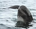 Long-finned pilot whalesspyhoppingoff Cape Breton


See also[edit]
References[edit]
- ^Canada, Parks."Parks Canada attendance 2022_23 - Parks Canada attendance 2022_23 - Open Government Portal".open.canada.ca.Retrieved2024-05-07.
- ^"Geographical Names of Canada - Cape Breton Highlands National Park of Canada".Government of Canada.Retrieved16 June2018.
- ^"Cape Breton Highlands National Park, Cabot Trail".Archived fromthe originalon 2000-04-13.Retrieved2011-03-29.
- ^Finkelstein, Maxwell W. (9 February 2010)."Cape Breton Highlands National Park".The Canadian Encyclopedia.Historica Canada.Archivedfrom the original on 11 January 2018.Retrieved29 March2011.
- ^ab"Cape Breton Highlands National Park".Parks Canada.24 March 2015.Retrieved30 March2014.
- ^"Cape Breton Highlands National Park".Government of Canada.Retrieved24 March2019.
- ^"Cheticamp - Cape Breton Island - Nova Scotia".Archived fromthe originalon 24 May 2011.Retrieved29 March2011.
- ^Lauff, R.F. (2010)."First nest record of the Boreal OwlAegolius funereusin Nova Scotia ".Ardea.97(4): 497–502.doi:10.5253/078.097.0414.S2CID86525931.
- ^Lauff, Randolph F. (Oct–Nov 2007). Johnson, D.H.; Van Nieuwenhuyse, D.; Duncan, J.R. (eds.).First nest records of the Boreal OwlAegolius funereusin Nova Scotia, Canada(PDF).Proc. Fourth World Owl Conf.Project Owl Net.Vol. 97, no. 4. Groningen, The Netherlands: Ardea. pp. 497–502.Retrieved26 May2015.
- ^"IBA Site Listing".www.ibacanada.org.Retrieved2021-02-03.
- ^"Eastern coyote - Cape Breton Highlands National Park".20 November 2018.
- ^"Saltwire | Halifax".
- ^"Moose - Cape Breton Highlands National Park".20 November 2018.
- ^"Woman airlifted after attack by coyotes in Cape Breton".CTV News.Sydney, Nova Scotia. Canadian Press. 27 October 2009.Retrieved26 May2015.
- ^"Cape Breton coyote attack kills touring folk singer".CTV News.28 October 2009.Retrieved19 September2014.
- ^abHild, Martha; Barr, Sandra (2015).Geology of Nova Scotia.Portugal Cove: Boulder Publications. pp. 18–21.ISBN9781927099438.
- ^Williams, Harold (1995).Geology of the Appalachian-Caledonian Orogen in Canada and Greenland, Geology of Canada, no. 6.Canada: Geological Survey of Canada. pp. 51, 59.ISBN0-660-13134-X.
- ^abcdeKeppie, J.D. (compiler) (2000).Geological Map of the Province of Nova Scotia, Map ME 2000-1, scale 1:500 000.Nova Scotia Department of Natural Resources, Minerals and Energy Branch.
- ^Baird, David (1971).Cape Breton Highlands National Park, where the mountains meet the sea, Misc. Report 5.Ottawa: The Geological Survey of Canada, Dept. of Mines and Technical Surveys. pp. 28–32.
- ^Dawson, William (1891).The Geology of Nova Scotia, New Brunswick, and Prince Edward Island, or Acadian Geology.London: MacMillan and Co. pp. 71, 83.
- ^Miller, Brent (1997).Geology, Geochronology, and Tectonic Significance of the Blair River Inlier, Northern Cape Breton Island, Nova Scotia.Halifax: Dalhousie University.
| International | |
|---|---|
| National | |
- IUCN Category II
- National parks in Nova Scotia
- Tourist attractions in Victoria County, Nova Scotia
- Tourist attractions in Inverness County, Nova Scotia
- Protected areas established in 1936
- Geography of Inverness County, Nova Scotia
- Geography of Victoria County, Nova Scotia
- 1936 establishments in Nova Scotia
- Important Bird Areas of Nova Scotia