
Cape Nosappu

Cape Nosappu(Nạp sa bố giáp,Nosappu-misaki)is a point on theNemuro Peninsula,Nemuro,Japan,[1]which is the easternmost point inHokkaidō.It is also the easternmost point in Japan which is open to the public. It is located where the waters from thePacific Oceanmeet those from theSea of Okhotsk.TheCape Nosappu Lighthouseis the oldest in Hokkaidō, built in 1872.[2]
The cape is very close to theHabomai Archipelago,which is administered byRussia.The closest island,SignalnyRock, is just 3.7 km away. As such, Russianpatrol boatsfrequently appear on the strait. However, Japan claims the sovereignty over these islands. (SeeKuril Islands dispute.)[3]Consequently, the cape houses a lot of monuments dealing with Japanese claims on the territories, such as the House of Nostalgia for the Homeland, the Bridge on the Four Islands, and others.
Gallery
[edit]-
 Russian ship abandoned after being stranded off Cape Nosappu Lighthouse (2009 August)
 -
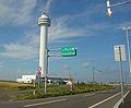 Aurora Tower
 -
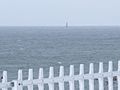 Signalny Rock, viewed from Cape Nosappu
 -
 Landsat Image
 -
 The Four Islands Bridge,a monument dedicated to praying for the return of theHabomai Islandsto Japanese sovereignty.


Climate
[edit]| Climate data for Cape Nosappu, 1991–2020 normals, extremes 1977–present | |||||||||||||
|---|---|---|---|---|---|---|---|---|---|---|---|---|---|
| Month | Jan | Feb | Mar | Apr | May | Jun | Jul | Aug | Sep | Oct | Nov | Dec | Year |
| Record high °C (°F) | 7.5 (45.5) |
7.0 (44.6) |
12.9 (55.2) |
23.0 (73.4) |
31.6 (88.9) |
31.0 (87.8) |
30.2 (86.4) |
33.5 (92.3) |
29.7 (85.5) |
23.7 (74.7) |
17.9 (64.2) |
11.9 (53.4) |
33.5 (92.3) |
| Mean daily maximum °C (°F) | −0.7 (30.7) |
−1.2 (29.8) |
1.8 (35.2) |
6.7 (44.1) |
10.9 (51.6) |
13.8 (56.8) |
17.8 (64.0) |
20.4 (68.7) |
19.4 (66.9) |
14.8 (58.6) |
8.9 (48.0) |
2.4 (36.3) |
9.6 (49.2) |
| Daily mean °C (°F) | −3.0 (26.6) |
−3.7 (25.3) |
−1.0 (30.2) |
3.0 (37.4) |
6.8 (44.2) |
10.1 (50.2) |
14.0 (57.2) |
16.8 (62.2) |
16.0 (60.8) |
11.7 (53.1) |
5.8 (42.4) |
−0.2 (31.6) |
6.4 (43.4) |
| Mean daily minimum °C (°F) | −5.9 (21.4) |
−6.7 (19.9) |
−4.0 (24.8) |
−0.1 (31.8) |
3.8 (38.8) |
7.3 (45.1) |
11.3 (52.3) |
14.2 (57.6) |
13.2 (55.8) |
8.4 (47.1) |
2.4 (36.3) |
−3.3 (26.1) |
3.4 (38.1) |
| Record low °C (°F) | −16.4 (2.5) |
−19.6 (−3.3) |
−18.1 (−0.6) |
−7.9 (17.8) |
−4.0 (24.8) |
1.3 (34.3) |
3.8 (38.8) |
7.0 (44.6) |
4.9 (40.8) |
−0.4 (31.3) |
−7.3 (18.9) |
−13.0 (8.6) |
−19.6 (−3.3) |
| Averageprecipitationmm (inches) | 18.9 (0.74) |
14.6 (0.57) |
37.4 (1.47) |
53.9 (2.12) |
82.9 (3.26) |
93.6 (3.69) |
107.7 (4.24) |
116.3 (4.58) |
130.6 (5.14) |
103.3 (4.07) |
75.2 (2.96) |
49.2 (1.94) |
883.6 (34.78) |
| Average precipitation days(≥ 1.0 mm) | 5.6 | 4.3 | 6.5 | 7.8 | 9.7 | 8.9 | 9.8 | 10.3 | 10.1 | 9.3 | 9.6 | 7.9 | 99.8 |
| Mean monthlysunshine hours | 150.2 | 169.9 | 202.2 | 190.2 | 169.0 | 134.3 | 116.8 | 129.0 | 153.2 | 168.9 | 145.9 | 145.0 | 1,875.2 |
| Source 1:JMA[4] | |||||||||||||
| Source 2:JMA[5] | |||||||||||||
See also
[edit]References
[edit]- ^DK (21 February 2017).DK Eyewitness Travel Guide Japan.DK Publishing. pp. 295–.ISBN978-1-4654-6432-3.
- ^Ann B. Irish (17 September 2009).Hokkaido: A History of Ethnic Transition and Development on Japan’s Northern Island.McFarland. pp. 20–.ISBN978-0-7864-5465-5.
- ^Akihiro Iwashita (30 October 2015).Japan's Border Issues: Pitfalls and Prospects.Routledge.ISBN978-1-317-42401-7.
- ^Quan trắc sử thượng 1~10 vị の trị ( niên gian を thông じての trị ).JMA.Retrieved16 February2022.
- ^Khí tượng sảnh / bình niên trị ( niên ・ nguyệt ごとの trị ).JMA.Retrieved16 February2022.
External links
[edit]43°23′07″N145°49′02″E/ 43.38528°N 145.81722°E
This Hokkaidō location article is astub.You can help Wikipedia byexpanding it. |