
Cheb
Cheb | |
|---|---|
 Krále Jiřího z Poděbrad Square | |
 Flag  Coat of arms | |
 Cheb Location in the Czech Republic | |
| Coordinates:50°4′46″N12°22′14″E/ 50.07944°N 12.37056°E | |
| Country | |
| Region | Karlovy Vary |
| District | Cheb |
| First mentioned | 1061 |
| Government | |
| • Mayor | Jan Vrba (ANO) |
| Area | |
| • Total | 96.36 km2(37.20 sq mi) |
| Elevation | 459 m (1,506 ft) |
| Population (2024-01-01)[1] | |
| • Total | 32,825 |
| • Density | 340/km2(880/sq mi) |
| Time zone | UTC+1(CET) |
| • Summer (DST) | UTC+2(CEST) |
| Postal code | 350 02 |
| Website | www |
Cheb(Czech pronunciation:[xɛp];German:Eger) is a town in theKarlovy Vary Regionof theCzech Republic.It has about 33,000 inhabitants. It lies on theOhřeriver.
Before theexpulsion of Germansin 1945, the town was the centre of the German-speaking region known asEgerland.The historic town centre is well preserved and is protected by law as anurban monument reservation.
Administrative parts
[edit]Cheb is formed by 19 town parts and villages:[2]
- Bříza
- Cetnov
- Cheb
- Chvoječná
- Dolní Dvory
- Dřenice
- Háje
- Horní Dvory
- Hradiště
- Hrozňatov
- Jindřichov
- Klest
- Loužek
- Pelhřimov
- Podhoří
- Podhrad
- Skalka
- Střížov
- Tršnice
Etymology
[edit]
The first name of the town, documented in 1061, wasEgire.It was a Latin name, which was derived from the Celtic name of theOhřeRiverAgara.The German nameEgerwas then derived from the Latin name.[3]
The Czech nameChebfirst appeared in the mid-14th century. The name is derived from the old Czech wordheb(modern Czechoheb, ohyb), which means "bend". It is related to bends of the Ohře River.[4]
Geography
[edit]Cheb is located about 38 kilometres (24 mi) southwest ofKarlovy Varyon the border withGermany.The town lies on the riverOhře.The northern and western parts of the municipal territory lie in theFichtel Mountains;the rest of the territory lies in theCheb Basin,named after the town. The highest point is the hill Zelená hora at 637 m (2,090 ft) above sea level.
There are two largereservoirsin the municipal territory: Skalka (northeast of the town and supplied by the Ohře) and Jesenice (southeast of the town and supplied by theWondreb). There are also several small ponds, especially in the southern part of the territory.
Climate
[edit]| Climate data for Cheb (1991–2020 normals, extremes 1961–2020) | |||||||||||||
|---|---|---|---|---|---|---|---|---|---|---|---|---|---|
| Month | Jan | Feb | Mar | Apr | May | Jun | Jul | Aug | Sep | Oct | Nov | Dec | Year |
| Record high °C (°F) | 14.6 (58.3) |
17.3 (63.1) |
22.6 (72.7) |
28.8 (83.8) |
31.2 (88.2) |
36.2 (97.2) |
37.0 (98.6) |
36.9 (98.4) |
31.2 (88.2) |
26.1 (79.0) |
17.5 (63.5) |
14.1 (57.4) |
37.0 (98.6) |
| Mean daily maximum °C (°F) | 1.6 (34.9) |
3.5 (38.3) |
8.3 (46.9) |
14.2 (57.6) |
18.7 (65.7) |
22.0 (71.6) |
24.1 (75.4) |
24.0 (75.2) |
18.7 (65.7) |
12.6 (54.7) |
6.0 (42.8) |
2.0 (35.6) |
13.0 (55.4) |
| Daily mean °C (°F) | −1.0 (30.2) |
−0.2 (31.6) |
3.5 (38.3) |
8.3 (46.9) |
12.8 (55.0) |
16.2 (61.2) |
17.9 (64.2) |
17.4 (63.3) |
12.8 (55.0) |
8.1 (46.6) |
3.4 (38.1) |
0.0 (32.0) |
8.3 (46.9) |
| Mean daily minimum °C (°F) | −3.6 (25.5) |
−3.4 (25.9) |
−0.4 (31.3) |
2.9 (37.2) |
7.0 (44.6) |
10.4 (50.7) |
12.1 (53.8) |
11.8 (53.2) |
8.2 (46.8) |
4.6 (40.3) |
0.9 (33.6) |
−2.2 (28.0) |
4.0 (39.2) |
| Record low °C (°F) | −24.6 (−12.3) |
−22.5 (−8.5) |
−21.5 (−6.7) |
−8.6 (16.5) |
−4.1 (24.6) |
−0.6 (30.9) |
2.2 (36.0) |
0.7 (33.3) |
−1.8 (28.8) |
−9.2 (15.4) |
−13.6 (7.5) |
−25.6 (−14.1) |
−25.6 (−14.1) |
| Averageprecipitationmm (inches) | 41.9 (1.65) |
31.0 (1.22) |
37.9 (1.49) |
33.6 (1.32) |
56.9 (2.24) |
70.5 (2.78) |
76.8 (3.02) |
69.5 (2.74) |
53.8 (2.12) |
46.1 (1.81) |
44.0 (1.73) |
46.9 (1.85) |
609.0 (23.98) |
| Average snowfall cm (inches) | 26.6 (10.5) |
20.5 (8.1) |
11.1 (4.4) |
2.8 (1.1) |
0.0 (0.0) |
0.0 (0.0) |
0.0 (0.0) |
0.0 (0.0) |
0.0 (0.0) |
0.3 (0.1) |
9.2 (3.6) |
19.3 (7.6) |
89.8 (35.4) |
| Average precipitation days(≥ 1.0 mm) | 10.2 | 8.0 | 9.3 | 7.7 | 9.5 | 9.5 | 10.8 | 9.4 | 8.1 | 9.3 | 9.2 | 10.2 | 111.4 |
| Averagerelative humidity(%) | 86 | 82 | 77 | 72 | 70 | 71 | 71 | 74 | 78 | 82 | 86 | 87 | 78 |
| Averagedew point°C (°F) | −4.5 (23.9) |
−3.7 (25.3) |
−1.3 (29.7) |
1.6 (34.9) |
6.0 (42.8) |
9.4 (48.9) |
10.8 (51.4) |
10.8 (51.4) |
8.6 (47.5) |
4.8 (40.6) |
0.3 (32.5) |
−2.9 (26.8) |
3.3 (38.0) |
| Mean monthlysunshine hours | 43.8 | 74.3 | 118.1 | 177.3 | 206.7 | 212.2 | 224.6 | 214.1 | 149.1 | 96.1 | 39.0 | 32.6 | 1,587.8 |
| Source:NOAA(humidity, dew point and snowfall 1961–1990)[5][6] | |||||||||||||
History
[edit]


The earliest settlement in the area was aSlavicgordat what is now known as the Cheb Castle complex, north of the town centre.[7]In 807 the district of today's Cheb was included in the newmargraviateofEast Franconia,which belonged at first to theBabenbergs,but from 906 to the margraves (marquis) ofVohburg.[8]
The first written mention of Cheb is from 1061.[9][10]Děpolt IIfounded the castle on the site of the gord around 1125.[11]In 1149, Cheb was described as a fortified marketplace. EmperorFrederick Barbarossaacquired Cheb in 1167. In 1203, it was first referred to as a town. It became the centre of a historical region calledEgerland.[9][10]
From 1266 to 1276, the town was property of KingOttokar II of Bohemia.The historic town centre was established after the fire in 1270. KingWenceslaus II of Bohemiaheld the town in 1291–1304, thenAlbert I of Germanyacquired the region. It wasn't until 1322 that Cheb became a permanent part of theLands of the Bohemian Crown,when KingJohn of Bohemiaacquired it from EmperorLouis IV.[9][11]The later local history was marked by continued resistance against incorporation into Bohemia.[12]
On 5 May 1389, during aReichstagbetween KingWenceslaus IVand a group of Imperial Free Cities ofsouthwest Germany,theTreaty of Egerwas agreed upon, after Wenceslaus had failed to secure his interests in the town.[10]In the 15th century, Cheb was one of the largest and wealthiest towns ofKingdom of Bohemiawith 7,300 inhabitants.[9]
The town suffered severely during theHussite Wars,during theSwedishinvasion in theThirty Years' Warin 1631 and 1647, and in theWar of the Austrian Successionin 1742.[8]In 1634, during the Thirty Years' War,Albrecht von Wallensteinwas killed here. In 1723, Cheb became afree royal town.The northern part of the old town was devastated by a large fire in 1809, and many middle-age buildings were destroyed.[10]
In 1757, the town's financial self-government was abolished for the sake of Austrian centralization. In 1848, the citizen's council demanded separation from Bohemia and reconstitution of itsLandtag.[12]
The terms of the1919 Treaty of Saint-Germain-en-Layetriggered civil unrest between theSudeten Germanpopulation and the newFirst Czechoslovak Republic,just as in the rest of theSudetenland.In the interwar period, many ethnic Czechs came to the town with the boom of industry.[9]
During theSudeten Crisis,the town was occupied by theNazi German-sponsoredSudetendeutsches Freikorpsparamilitary group.[13]On 3 October 1938, the town was visited byAdolf Hitler;shortly afterwardWehrmachttroops marched into the Sudetenland and seized control. From 1938 until 1945, the town was annexed to Germany and was administered as part of theReichsgau Sudetenland.TheGestapoandOrdnungspolizeioperated a prison in Cheb, whose prisoners were subjected toforced labour.[14]Cheb was liberated by the97th Infantry Divisionof theUnited States Armyon 25 April 1945.[15]
After the end ofWorld War IIthe region was returned to Czechoslovakia. Under theBeneš decreesandPotsdam Agreementof the same year, the German-speaking majority wasexpelled.
Demographics
[edit]In 1910, only 0.5% of the population were Czech.[16]Until 1945, it was part of theNorthern Bavariandialect area. After World War II, due to the expulsion of ethnic Germans and resettlement of Czechs, the population significantly dropped.
|
|
| ||||||||||||||||||||||||||||||||||||||||||||||||||||||
| Source: Censuses[17][18] | ||||||||||||||||||||||||||||||||||||||||||||||||||||||||
The current population includes a large group ofVietnamese people.[19]Their families were invited to the country asguest workersduring theCommunist era.[20]
Economy
[edit]The pillars of Cheb's economy are mainly services and tourism, and there are no large companies here. The largest employer is the Town of Cheb. Only four industrial enterprises with 200–250 employees are based in Cheb:BWI Czech Republic(manufacturer of automobile parts),Nexans Power Accessories Czech Republic(manufacturer of components for conductors),Playmobil CZ(toys manufacturer), and Tritia (bakery).[21]
Many entrepreneurs and small traders come from the large Vietnamese community. After theVelvet Revolutionin 1989, the Vietnamese community gradually established seven markets here, and even customers from Germany came to Cheb for cheap goods. Today, three Vietnamese markets operate here.[19]
Transport
[edit]
TheD6 motorwayfromPraguetoKarlovy Varyand Cheb (part of the European routesE48andE49) forks in Cheb and continues to the Czech-German border to the west (as E48) and to the north (as E49).
Cheb is an important railway junction. The town lies on the railway line of national importance fromFrantiškovy LáznětoPlzeň,Prague,OlomoucandOstrava.Other railway lines that pass through the town are Prague–Chomutov–Cheb,Nuremberg–Cheb,Hof–Marktredwitz,Zwickau–Cheb and Cheb–Luby.In addition to the main railway station, the town is also served by the Cheb-Skalka station.[22]
Cheb Airportis located 3 kilometres (2 mi) east of the town centre. It is the second-oldest airport in the country and the oldest still existing.[23]
Education
[edit]Cheb is known for itsCheb Violin Making School.
Two faculties of theUniversity of West Bohemia,pedagogical and economic, have a detached workplace in Cheb and open study programs there.[24]
Sport
[edit]The town is represented by the football clubFK Hvězda Cheb.It plays in the 4th tier of the Czech football system. Its predecessor was the club FC Union Cheb, which played in theCzechoslovakandCzech First Leaguefrom 1979 to 1996, but then was abolished due to financial reasons.[25]The team play at the Lokomotiva Stadium, located on streetU Stadionu.
The Lokomotiva Stadium once heldmotorcycle speedway[26]and hosted a final round of theCzechoslovak Individual Speedway Championshipfor three consecutive years from 1966 to 1968.[27]
Sights
[edit]
Cheb Castle
[edit]On the rock in the northwest of the historic town centre lies Cheb Castle. It was founded around 1125 and was rebuilt into aKaiserpfalzat the end of the 12th century. It is the only example of a Kaiserpfalz in the Czech Republic. At the turn of the 17th and 18th centuries, the castle was partially rebuilt into a Baroque fortress citadel. Although the castle is mostly a ruin, the torso of the palace, the defensive Black Tower and the Chapel of Saints Martin Erhard and Ursula.[11]
The Chapel of Saints Martin, Erhard and Ursula is a unique Romanesque-Gothic double chapel. It is the best preserved example of theHohenstaufenarchitecture in Central Europe. The chapel has two storeys; the lower storey is inRomanesquestyle, while the upper storey isGothic.On the first floor, there are original capitals of marble columns, decorated with figurative scenes of angels with Bibles as well as lewd scenes.[28]
Town square
[edit]
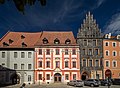
In the centre of the historic town centre is the Krále Jiřího z Poděbrad Square. One of the symbols of the Cheb architecture is a group of houses known asŠpalíček.It is located in the middle of the town square and dates from the 13th century. The bizarre complex of eleven houses consists of narrow, four and five-storey houses without a courtyard, divided by a 1.6 metres (5.2 ft) wide alley. They are mostly in the late Gothic style. The outline of the two blocks can still be seen on the oldest existing records of 1472.[29]
The most valuable burgher house on the town square is the Schirdinger House. It is a Gothic house, built at the beginning of the 13th century and restored after the fire in the 15th century. The Renaissance reconstruction took place in 1622–1626. Today it houses a gallery and a café.[30]
Among the other valuable houses on the town square is the Town House, also known as Pachelbel's House or Juncker House. The house was first mentioned already in the 14th century. On 24 February 1634,Albrecht von Wallensteinwas murdered here. Since 1873, the house serves as the town museum. The museum was later expanded to the neighbouring house.[31]
The Grüner House on the town square is a Gothic-Baroque house. It belonged to the well-known Wrendl family from 1591 until 1876, whose family coat of arms is above the entrance. When the house was owned by magistrate councillor Grüner in the first half of the 19th century,Johann Wolfgang von Goethefrequently spent time here.[32]
Sacral monuments
[edit]

The Church of Saints Nicholas and Elisabeth is the main church of the town and the oldest late Gothic building. It was established as a three-naved Romanesquebasilicain the 1220s, of which the western portal and the lower part of the tower remain in place. After the fire in 1270, it was rebuilt in the Gothic style, another reconstruction took place in the 1470s. After the fire of 1742, the tower was rebuilt with a Baroquecupola,according to the design of the indigenous architectBalthasar Neumann.The top of the twin steeples were destroyed by bombardment at the end ofWorld War IIand restored in summer 2008. The church tower is open to the public as a lookout lower.[33][34]
TheFranciscanmonastery with the Church of the Annunciation was founded in 1256 and rebuilt after the fire in 1270. The church is one of the oldest Gothic hall churches in the country. Today the former monastery is owned by the town and is used as the venue of occasional concerts. The monastery also includes publicly accessible monastery garden.[35]
The monastery of the order ofPoor Clareswith the Church of Saint Clare was founded at the end of the 13th century next to the Franciscan monastery. In 1707–1709, it was demolished and built again according to the design ofChristoph Dientzenhofer.The monastery was abolished in 1782 and the buildings served various purposes.[36]
TheDominicanmonastery with the Church of Saint Wenceslaus was built in 1294–1296. The monastery was badly damaged and the church destroyed during the Thirty Years' War. The new Baroque church was built in 1674–1688. The monastery was dissolved in 1950. The church is still in use, the convent now serves cultural purposes.[37]
The early Baroque pilgrimage complex Maria Loreto was founded in the village of Starý Hrozňatov (today just Hrozňatov). It was founded next to the Church of the Holy Spirit, which dates from 1557. It belongs to the most visited pilgrimage sites in the country. The complex was built in 1664 and extended in 1675–1683. TheStations of the Crossthat leads to Maria Loreto was originally composed of twenty-nine stations.[38][39]
Notable people
[edit]- Johannes Widmann(c. 1460– after 1498), German mathematician
- Johann Habermann(1516–1590), German Lutheran theologian
- Albrecht von Wallenstein(1583–1634), military leader and statesman; died here
- Johann Georg Macasius(1617–1653), German physician
- Pavel Klein(1652–1717), Jesuit missionary, botanist, writer
- Balthasar Neumann(1687–1753), German architect and military artillery engineer
- Barbara Schack(1874–1958), Czechoslovak-German politician
- Hugo Zuckermann(1881–1914), Jewish-Austrian poet
- Rudolf Serkin(1903–1991), Czech-American pianist
- Erich Riedl(1933–2018), German politician
- Neda Al-Hilali(born 1938), American fiber artist and weaver
- Peter Glotz(1939–2005), German politician and social scientist
- Norbert Singer(born 1939), German automotive engineer
- Pavel Nedvěd(born 1972), footballer, 2003Ballon d'Orwinner
Twin towns – sister cities
[edit] Bắc Ninh,Vietnam
 Hof,Germany
 Nová Dubnica,Slovakia
Sincethe fall of the Iron Curtain,Cheb has also had cordial relationships with the neighbouring German towns ofWaldsassenandMarktredwitz.
Gallery
[edit]-
 Historic houses on the town square
 -
 Sand Gate near the Ohře
 -
 Cheb Theatre
 -
 Gardens of the Franciscan monastery


See also
[edit]- Madonna with St John the Baptist and St John the Evangelist (Cheb)
- Winged Altarpiece of Our Lady from Seeberg
References
[edit]- ^"Population of Municipalities – 1 January 2024".Czech Statistical Office.2024-05-17.
- ^"Části obcí".Územně identifikační registr ČR(in Czech).Retrieved2023-11-14.
- ^Nová, Alena (2023-03-18)."Jak dobře znáte Chebsko. Otestujte se v kvízu Deníku".Chebský Deník(in Czech). Deník.cz.Retrieved2023-03-23.
- ^"O původu názvů západočeských měst I"(in Czech).Czech Radio.2004-04-02.Retrieved2022-06-07.
- ^"World Meteorological Organization Climate Normals for 1991-2020 — Cheb".National Oceanic and Atmospheric Administration.Retrieved2024-01-12.
- ^"Cheb Climate Normals 1961–1990".National Oceanic and Atmospheric Administration.Retrieved2015-03-29.
- ^"Slovanské pohřebiště"(in Czech). Cheb Castle.Retrieved2022-06-07.
- ^abOne or more of the preceding sentences incorporates text from a publication now in thepublic domain:Chisholm, Hugh,ed. (1911). "Eger".Encyclopædia Britannica.Vol. 9 (11th ed.). Cambridge University Press. p. 12.
- ^abcde"Generel veřejného osvětlení"(in Czech). Město Cheb. September 2019. p. 9.Retrieved2023-03-23.
- ^abcd"Časová osa".Encyklopedie města Cheb(in Czech).Retrieved2023-03-23.
- ^abc"Příběh Chebského hradu"(in Czech). Cheb Castle.Retrieved2023-03-23.
- ^abFriedrich Prinz, ed. (1993).Deutsche Geschichte im Osten Europas: Böhmen und Mähren(in German). Siedler. p. 241.
- ^Bouverie, Tim (2019).Appeasement: Chamberlain, Hitler, Churchill, and the Road to War(1st ed.). New York:Tim Duggan Books.p. 260.ISBN978-0-451-49984-4.OCLC1042099346.
- ^"Gestapogefängnis Eger".Bundesarchiv.de(in German).Retrieved2023-11-07.
- ^"Welcome to the 97th Infantry Division".97thdivision.com.
- ^Ernst Pfohl:Ortslexikon Sudetenland.page 124. Helmut Preußler Verlag-Nürnberg. 1987.ISBN3-925362-47-9
- ^"Historický lexikon obcí České republiky 1869–2011 – Okres Cheb"(in Czech). Czech Statistical Office. 2015-12-21. pp. 3–4.
- ^"Population Census 2021: Population by sex".Public Database.Czech Statistical Office.2021-03-27.
- ^ab""Billig, billig." Němci chebské tržnice milovali, Vietnamci už ale chtějí žít jinak "(in Czech). Aktuálně.cz. 2020-10-29.Retrieved2023-03-23.
- ^"Vietnamci jsou v Česku už přes šedesát let. Nová generace žije jinak".Deník.cz(in Czech). 2022-05-23.Retrieved2023-03-23.
- ^"Registr ekonomických subjektů".Business Register(in Czech). Czech Statistical Office.Retrieved2023-03-23.
- ^"Detail stanice Cheb"(in Czech).České dráhy.Retrieved2023-03-23.
- ^"Chebské letiště je nejstarší v České republice".Chebský deník(in Czech). Deník.cz. 2007-05-12.Retrieved2020-11-23.
- ^"Západočeská univerzita rozšiřuje činnost své Fakulty pedagogické v Chebu"(in Czech). Město Cheb. 2021-06-21.Retrieved2023-03-23.
- ^"O klubu"(in Czech). FK Hvězda Cheb. Archived fromthe originalon 2023-03-27.Retrieved2023-03-23.
- ^"Abeceda ploché dráhy – písmeno" CH "".speedwayfakta.cz(in Czech).Retrieved2024-03-30.
- ^"Individual Czechoslovak Championship".historyspeedway.nstrefa.pl(in Polish).Retrieved2024-03-30.
- ^"Kaple sv. Erharda a Uršuly – dvojitá kaple"(in Czech). Cheb Castle.Retrieved2023-03-24.
- ^"Špalíček".Encyklopedie města Cheb(in Czech).Retrieved2022-06-07.
- ^"Schirdingerovský dům"(in Czech). National Heritage Institute.Retrieved2023-03-24.
- ^"Town House".Visit Cheb.Retrieved2023-03-24.
- ^"Grüner House".Visit Cheb.Retrieved2023-03-24.
- ^"Church of Saint Nicholas".Visit Cheb.Retrieved2023-03-24.
- ^"Kostel sv. Mikuláše"(in Czech). National Heritage Institute.Retrieved2023-03-24.
- ^"Franciscan Church and Monastery".Visit Cheb.Retrieved2023-03-24.
- ^"Kostel sv. Mikuláše"(in Czech). National Heritage Institute.Retrieved2023-03-24.
- ^"Dominikánský klášter s kostelem sv. Václava"(in Czech). National Heritage Institute.Retrieved2023-03-24.
- ^"Loreta"(in Czech). National Heritage Institute.Retrieved2023-03-24.
- ^"Loreta Starý Hrozňatov – poutní areál Maria Loreto"(in Czech). CzechTourism.Retrieved2023-03-24.
- ^"Partnerská města"(in Czech). Město Cheb.Retrieved2022-10-04.
External links
[edit]- Official website
- Visit Cheb– Interactive encyclopedia of Cheb
- Tourist Information Centre
- Cheb Castle official website
- Euregio Egrensis(in Czech)
| International | |
|---|---|
| National | |