
Check dam


Acheck damis a small, sometimes temporary,damconstructed across aswale,drainage ditch,or waterway to counteracterosionby reducing water flow velocity.[1]Check dams themselves are not a type of new technology; rather, they are an ancient technique dating from the second century AD.[2]Check dams are typically, though not always, implemented in a system of several dams situated at regular intervals across the area of interest.[3]

Function[edit]
A check dam placed in theditch,swale, orchannelinterrupts the flow of water and flattens the gradient of the channel, thereby reducing the velocity. In turn, this obstruction inducesinfiltrationand reduceseroding.[1]They can be used not only to slow flow velocity but also to distribute flows across a swale to avoid preferential paths and guide flows toward vegetation.[4]Although somesedimentationmay result behind the dam, check dams do not primarily function as sediment-trapping devices.[5]
For instance, on theGraliwdoRiver in Ethiopia, an increase ofhydraulic roughnessby check dams and water transmission losses in deposited sediments is responsible for the delay of runoff to reach the lower part of the river channels. The reduction of peak runoff discharge was larger in the river segment with check dams and vegetation (minus 12%) than in segment without treatment (minus 5.5%). Reduction of total runoff volume was also larger in the river with check dams than in the untreated river. The implementation of check dams combined with vegetation reducedpeak flowdischarge and total runoff volume as large parts of runoff infiltrated in the sediments deposited behind the check dams. As gully check dams are implemented in a large areas of northern Ethiopia, this contributes togroundwater rechargeand increased river base flow.[6]
Applications[edit]
Grade control mechanism[edit]
Check dams have traditionally been implemented in two environments: across channel bottoms and on hilly slopes.[7]Check dams are used primarily to control water velocity, conserve soil, and improve land.[8]They are used when other flow-control practices, such as lining the channel or creatingbioswales,are impractical.[9]Accordingly, they are commonly used in degrading temporary channels, in which permanent stabilization is impractical and infeasible in terms of resource allocation and funding due to the short life period. They are also used when construction delays and weather conditions prevent timely installation of other erosion control practices.[10]This is typically seen during the construction process of large-scale permanentdamsor erosion control. As such, check dams serve as temporary grade-control mechanisms along waterways until resolute stabilization is established or along permanent swales that need protection prior to installation of a non-erodible lining.[11]
Water quality control mechanism[edit]
Many check dams tend to formstream pools.Under low-flow circumstances, water eitherinfiltratesinto the ground,evaporates,or seeps through or under the dam. Under high flow –flood– conditions, water flows over or through the structure. Coarse and medium-grained sediment fromrunofftends to be deposited behind check dams, while finer grains flow through. Floating garbage is also trapped by check dams, increasing their effectiveness as water quality control measures.
Arid regions[edit]

In arid areas, check dams are often built to increasegroundwater rechargein a process called managed aquifer recharge. Winter runoff thus can be stored in aquifers, from which the water can be withdrawn during the dry season for irrigation, livestock watering, and drinking water. This is particularly useful for small settlements located far from a large urban center as check dams require less reliance on machinery, funding, or advanced knowledge compared to large-scale dam implementation.[12][2]
Check dams can be used in combination withlimansto stop and collectsurface runoffwater.
Mountainous regions[edit]
As a strategy to stabilize mountain streams, the construction of check dams has a long tradition in many mountainous regions dating back to the 19th century in Europe. Steep slopes impede access by heavy construction machinery to mountain streams, so check dams have been built in place of larger dams. Because the typical high slope causes high flow velocity, a terraced system of multiple closely spaced check dams is typically necessary to reduce velocity and thereby counteract erosion. Such consolidation check dams, built in terraces, attempt to prevent both headward and downward cutting into channel beds while also stabilizing adjacent hill slopes. They are further used to mitigate flood and debris flow hazards.[13]
Temporary Test Dams TTDs[edit]
In the UK planning laws, applications and restrictions delay flood mitigation work. This can be counteracted by setting up Temporary Test Dams in watercourses that can then be monitored and valued. This does however require the landowners support. TTDs have proven to be a great way to get rapid action following a flood event and a way to get communities involved in the defence against future flood events.
Design considerations[edit]
Site[edit]
Before installing a check dam, engineers inspect the site. Standard practices call for thedrainage areato be ten acres or less.[3][9]The waterway should be on a slope of no more than 50% and should have a minimum depth to bedrock of 2 ft (0.61 m).[14]Check dams are often used in natural or constructed channels or swales. They should never be placed in live streams unless approved by appropriate local, state and/or federal authorities.[14]
Materials[edit]
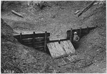

Check dams are made of a variety of materials. Because they are typically used as temporary structures, they are often made of cheap and accessible materials such as rocks, gravel, logs, hay bales, and sandbags.[9][15]Of these, logs and rock check dams are usually permanent or semi-permanent, and sandbag check dams are built primarily for temporary purposes. Also, there are check dams that are constructed with rockfill or wooden boards. These dams are usually implemented only in small, open channels that drain 10 acres (0.04 km2) or less; and usually do not exceed 2 ft (0.61 m) high.[16]Woven wire can be used to construct check dams in order to hold fine material in a gully. It is typically used in environments where the gully has a moderate slope (less than 10%), small drainage area, and in regions where flood flows do not typically carry large rocks or boulders.[17][15]In nearly all instances, erosion control blankets, which are biodegradable open-weave blankets, are used in conjunction with check dams. These blankets help encourage vegetation growth on the slopes, shorelines and ditch bottoms.

Size[edit]
Check dams are usually less than 2 to 3 feet (0.61 to 0.91 m) high.[18]and the center of the dam should be at least 6 in (0.15 m) lower than its edges.[9]This criterion induces a weir effect, resulting in increased water surface level upstream for some, if not all flow conditions.[19]
Spacing[edit]
In order to effectively slow water velocity to reduce erosion and to protect the channel between dams in a larger system, spacing must be designed properly. Check dams should be spaced such that the toe of the upstream check dam is equal to the elevation of the downstream check dam's crest.[20]This allows water to pond between dams and substantially slows the flow's velocity.[5]
Advantages[edit]
Check dams are a highly effective practice to reduce flow velocities in channels and waterways. In contrast to big dams, check dams are implemented faster, are cost effective, and are smaller in scope. Because of this, their implementation does not typically displace people and communities nor do they destroy natural resources if designed correctly.[21]Moreover, the dams are simple to construct and do not rely on advanced technologies, allowing their use in rural communities with fewer resources or access to technical expertise, as they have been in India's drylands for some time now.[21]
Limitations[edit]
Check dams still require maintenance and sediment removal practices. They become more difficult to implement on steep slopes, as velocity is higher and the distance between dams must be shortened.[5]Check dams, depending on the material used, can have a limited life span but if implemented correctly can be considered permanent.[5]
Maintenance[edit]
Check dams require regular maintenance as typically temporary structures not designed to withstand long-term use. Dams should be inspected every week and after heavy rainfall.[5]It is important that rubble, litter, and leaves are removed from the upstream side of the dam.[9]This is typically done when the sediment has reached a height of one-half the original height of the dam.[9]
When the site is permanently stabilized and the check dam is no longer needed, it is fully removed, including components washed downstream, and bare spots are stabilized.[5]
See also[edit]
References[edit]
- ^abMarsh, William M. (2010).Landscape Planning: Environmental Applications(5th ed.). Danvers, MA: John Wiley & Sons, Inc. pp. 267–268.ISBN978-0-470-57081-4.
- ^abAgoramoorthy, Govindasamy, Sunita Chaudhary & Minna J. Hsu (2008). "The Check-Dam Route to Mitigate India's Water Shortages".Natural Resources Journal.48(3): 565–583.
{{cite journal}}:CS1 maint: multiple names: authors list (link) - ^abMississippi Department of Environmental Quality.Erosion Stormwater Manual(PDF)(4th ed.). Mississippi DEQ. pp. 4–118.Archived(PDF)from the original on March 5, 2016.RetrievedOctober 21,2014.
- ^Melbourne Water (2005).Water Sensitive Urban Design Engineering Procedures: Stormwater.Australia: CSIRO Publishing. p. 140.ISBN978-0-643-09092-7.Retrieved28 October2014.
- ^abcdefIowa Statewide Urban Design and Specifications (SUDAS) (2013).Design Manual - Erosion and Sediment Control(PDF).Ames, IA: Institute for Transportation at Iowa State University. Archived fromthe original(PDF)on 9 November 2014.Retrieved28 October2014.
- ^Etefa Guyassa, and colleagues (2017)."Effects of check dams on runoff characteristics along gully reaches, the case of Northern Ethiopia".Journal of Hydrology.545:299–309.Bibcode:2017JHyd..545..299G.doi:10.1016/j.jhydrol.2016.12.019.hdl:1854/LU-8518957.Archivedfrom the original on 2021-05-07.Retrieved2020-08-31.
- ^Garcia, Carmelo & Mario Lenzi (2010).Check Dams, Morphological Adjustments and Erosion Control in Torrential Streams.New York: Nova Science Publishers.ISBN978-1-61761-749-2.
- ^A conceptual model of check dam hydraulics for gully control:efficiency, optimal spacing and relation with step-pools C. Castillo, R. Pérez, and J. A. Gómez from Hydrology and Earth System Sciences 18, 1705–1721, 2014
- ^abcdefUnited States Environmental Protection Agency (2014-08-06)."Water Best Management Practices: Check Dams".water.epa.gov.USEPA.Archivedfrom the original on 2015-09-01.Retrieved28 October2014.
- ^North Carolina Department of Environment and Natural Resources (2006).Practice Standards and Specifications.Raleigh, N.C.: NCDENR. pp. 6.83.1–6.83.3. Archived fromthe originalon 2013-07-24.Retrieved28 October2014.
- ^Urban Drainage and Flood Control District (2010).Urban Storm Drainage Criteria Manual Volume 3(PDF).Colorado: Urban Drainage and Flood Control District. Archived fromthe original(PDF)on 2012-09-05.Retrieved28 October2014.
- ^S. Parimala Renganayaki, L. Elango (April 2013). "A review on managed aquifer recharge by check dams: a case study near Chennai, India".: International Journal of Research in Engineering and Technology 2 (4): 416–423
- ^Mazzorana, Bruno (6 June 2014). "The susceptibility of consolidation check dams as a key factor for maintenance planning".Österreichische Wasser- und Abfallwirtschaft.66(5): 214–216.doi:10.1007/s00506-014-0160-4.S2CID130712151.
- ^abDepartment of Environmental Quality (2005).IDEQ Stormwater Best Management Practices Catalog: Check Dams BMP 32(PDF).State of Idaho. pp. 106–108. Archived fromthe original(PDF)on 22 December 2016.Retrieved28 October2014.
- ^abNyssen, J. and colleagues (2017)."Boulder-Faced Log Dams as an Alternative for Gabion Check Dams in First-Order Ephemeral Streams with Coarse Bed Load in Ethiopia".Journal of Hydraulic Engineering.143.doi:10.1061/(ASCE)HY.1943-7900.0001217.
- ^USDA Natural Resource Conservation Services (NRCS)."Urban BMPs: Water Erosion"(PDF).usda.gov.USDA.Retrieved28 October2014.[permanent dead link]
- ^"FAO Watershed Management Field Manual".fao.org.Food and Agricultural Organizations of the United Nations.Archivedfrom the original on 31 January 2019.Retrieved28 October2014.
- ^Urban BMPs: Water, erosion, check dams(PDF).United States Department of Agriculture.Retrieved4 November2014.[permanent dead link]
- ^Rickard, Charles & Rodney Day, Jeremy Purseglove (2003).River Weirs – Good Practice Guide(PDF).UK: Environment Agency. p. xi.Archived(PDF)from the original on 23 January 2017.Retrieved4 November2014.
{{cite book}}:CS1 maint: multiple names: authors list (link) - ^Sustainable Technologies Evaluation Program."Check dams".Low Impact Development Stormwater Management Planning and Design Guide.Archivedfrom the original on 8 December 2019.Retrieved28 March2018.
- ^abAgoramoorthy, Govindasamy, and Minna J. Hsu (2008). "Small Size, Big Potential: Check Dams for Sustainable Development".Environment.50(4): 22–34.Bibcode:2008ESPSD..50d..22A.doi:10.3200/envt.50.4.22-35.S2CID153334085.ProQuest224015181.
{{cite journal}}:CS1 maint: multiple names: authors list (link)
External links[edit]
- Trap Function of Bed Road by Steel-Slit DamSabo Gakkaishi Vol.45 (1992-1993) No.4 P22-29
| Authority control databases:National |
|---|