
Chisasibi
Chisasibi
ᒋᓵᓰᐲ chisaasiipii | |
|---|---|
| Cree Nation of Chisasibi | |
 Chisasibi Chisasibi (on theLa Grande River,belowLongue Pointe) | |
| Coordinates:53°47′N78°54′W/ 53.783°N 78.900°W[1] | |
| Country | Canada |
| Province | Quebec |
| Region | Nord-du-Québec |
| TE | Eeyou Istchee |
| Established | 1980 |
| Government | |
| • Type | Cree reserved land(TC) |
| • Chief | Daisy House[2] |
| Area (2021)[3] | |
| • Land | 825.11 km2(318.58 sq mi) |
| Population (2021)[3] | |
| • Total | 4,985 |
| • Density | 6.0/km2(16/sq mi) |
| Time zone | UTC−05:00(EST) |
| • Summer (DST) | UTC−04:00(EDT) |
| Postal Code | J0M 1E0 |
| Area code | 819 |
| Website | chisasibi.ca |
Chisasibi(Cree:ᒋᓵᓰᐲ,romanized:Cisâsîpî;meaningGreat River) is a village andCree reserved land(TC) on the eastern shore ofJames Bay,inEeyou Istchee,anequivalent territory(ET) inNord-du-Québec,Canada. It is situated on the south shore ofLa Grande River(the Grand River), less than 10 km (6.2 mi) from the river's mouth. Chisasibi is one of nineCreevillages in the region, and is a member of theGrand Council of the CreesofQuebec.[4]
The territory surrounding Chisasibi is part of the municipalityEeyou Istchee James Bay,of which parts are jointly managed by the municipalities of theJamésieTE and theCree Regional Authorityof the Eeyou Istchee TE.[5]
The land area of the town is 491.63 km2(189.82 sq mi) and the area of the associatedChisasibi Cree village municipalityis 825.11 km2(318.58 sq mi).[3]
History
[edit]The Cree have lived in the region for many centuries but were nomadic. In 1803, theHudson's Bay Companyfounded Fort George, a trading post on the north shore which was relocated to the largest island at the mouth of La Grande River in 1837. Fort George became a permanent village as the local Cree population abandoned their nomadic way of life in the early 20th century and settled nearby. In 1940, its population was about 750 and grew to almost 2,000 in 1980.[6]
In the mid-1970s, the construction of theJames Bay hydro-electric projectbegan, diverting upstream rivers into the La Grande watershed, increasing its flow significantly, resulting in erosion of Fort George Island (also called Governor's Island) and disruption to the formation of a solid ice cover in winter.[7]In response, the Quebec Government built a new community on the mainland's south shore, relocating the population and some 200 houses to the new site in 1981. The village was renamed Chisasibi (official name:Cree Nation of Chisasibi). At the same time, the Fort George Relocation Corporation was formed to oversee the relocation.[4][6]
The Cree Nation of Chisasibi
[edit]
Chisasibi is the most northern Cree village accessible by road and the northernmost community with year-round road access in eastern North America. A 90 km (56 mi) paved road, running fromRadissonand parallel toLa Grande River,connects Chisasibi to theJames Bay Road(French:Route de la Baie James).[5]The James Bay Road (formerly part ofRoute 109) was built from 1971 to 1974 as part of the James Bay hydroelectric project and connectsMatagamito Radisson.Chisasibi Airportis located 1.7nautical miles(3.1 km; 2.0 mi) northwest[8]of the village andAir Creebecoperates scheduled service from this airport. Though this is the most northern village, this is not where the road ends. FromLa Grande-1 generating station(LG-1), the road continues north to a location calledLongue Pointe(Long Point). It is the farthest north one can go by road east of theHudson Bay.
ManyCreein Chisasibi engage in hunting, trapping, and fishing activities, but all catch is for local consumption. Other economic activity includes local services (health care and education), employment byHydro-Québecand some hospitality services. An elected Chief, Deputy Chief, and Council help administer the Cree Nation of Chisasibi Office.
Other Cree villages near Chisasibi areWhapmagoostui,200 km (120 mi) to the north inNunavik,on the eastern shore of Hudson Bay near theNorthern villageofKuujjuarapik,andWemindji,about 100 km (62 mi) to the south.
Demographics
[edit]In the2021 Canadian censusconducted byStatistics Canada,Chisasibi had a population of 4,985 living in 1,056 of its 1,281 total private dwellings an increase of 2.3% from its2016 populationof 4,872. With a land area of 480.29 km2(185.44 sq mi), it had a population density of6.0/km2(15.6/sq mi) in 2021.[3]
As of the 2021 census the population of Chisasibi comprises 4,305Cree,345 otherFirst Nations,240Inuit,10Métis,and 245 non-native people.[3]The average age is 30.0 with 29.6 for men and 30.5 for women. The majority of the population is between 15 and 64 years old (61.5 per cent), 31.1 per cent are under 15 and 7.8 per cent are 65 and older.[3]
| Year | Pop. | ±% |
|---|---|---|
| 1991 | 2,306 | — |
| 1996 | 3,251 | +41.0% |
| 2001 | 3,467 | +6.6% |
| 2006 | 3,972 | +14.6% |
| 2011 | 4,484 | +12.9% |
| 2016 | 4,872 | +8.7% |
| 2021 | 4,985 | +2.3% |
| Source:Statistics CanadaCommunity Profiles | ||
Languages
[edit]Creeis spoken as the first language in Chisasibi, in addition to English, as a primary language for official dealings.[3]
Themother tongueof the majority of the residents is Cree at 81.3 per cent, with 6.6 per cent for otherindigenous languages.For Canada'sofficial languages,English is the mother tongue for 8.4 per cent and French for 2.9 per cent of the population. In addition 0.7 per cent report a non-Indigenous language as their mother tongue[3]
Around 76,4 per cent of the population speak English, with 3.5 per cent speaking French, 15.7 per cent speaking both English and French, and 4.4 per cent speaking neither.
There has been criticism of theQuebec language policywith respect to native languages, particularly Cree, many related toHydro-Québec's hydroelectric dam project in the James Bay region.
Education
[edit]
TheCree School Boardoperates Waapinichikush Elementary School (with 788 students)[9]and the James Bay Eeyou School, a high school, which has 494 students[10]French:École Eeyou De La Baie James;Cree:ᒉᐃᒥᔅ ᐯᐃ ᐄᔨᔨᐤ ᒋᔅᑯᑎᒫᒑᐅᑭᒥᒄ).[11]The Eeyou School opened in1980.[12]
Previously, the school provided boarding services for high schoolers from further afield of theJames Bayregion, such asEastmain,Whapmagoostui,andWemindji,as (at the time) all high school classes in the region were located in Chisasibi.[13]
In addition,adult educationis available in Chisasibi, includingvocationaland general education.[14]
Climate
[edit]Chisasibi has asubarctic climate(KöppenDfc), typical of the central latitudes of Quebec, with cold and snowy winters and mild, rainy summers.
| Climate data for Chisasibi, Quebec (1915-1969) | |||||||||||||
|---|---|---|---|---|---|---|---|---|---|---|---|---|---|
| Month | Jan | Feb | Mar | Apr | May | Jun | Jul | Aug | Sep | Oct | Nov | Dec | Year |
| Mean daily maximum °C (°F) | −17.5 (0.5) |
−15.6 (3.9) |
−9.1 (15.6) |
−0.1 (31.8) |
7.1 (44.8) |
14.1 (57.4) |
17.4 (63.3) |
15.9 (60.6) |
11.7 (53.1) |
5.5 (41.9) |
−1.8 (28.8) |
−10.8 (12.6) |
0.6 (33.1) |
| Daily mean °C (°F) | −23.3 (−9.9) |
−22.0 (−7.6) |
−15.8 (3.6) |
−5.7 (21.7) |
2.3 (36.1) |
8.8 (47.8) |
12.3 (54.1) |
11.5 (52.7) |
7.9 (46.2) |
2.5 (36.5) |
−4.8 (23.4) |
−15.2 (4.6) |
−4.3 (24.3) |
| Mean daily minimum °C (°F) | −29.0 (−20.2) |
−28.2 (−18.8) |
−22.4 (−8.3) |
−11.0 (12.2) |
−2.6 (27.3) |
3.3 (37.9) |
7.1 (44.8) |
7.1 (44.8) |
4.2 (39.6) |
−0.3 (31.5) |
−7.7 (18.1) |
−19.6 (−3.3) |
−9.2 (15.4) |
| Averageprecipitationmm (inches) | 25.1 (0.99) |
21.4 (0.84) |
26.0 (1.02) |
20.7 (0.81) |
32.7 (1.29) |
45.7 (1.80) |
77.3 (3.04) |
66.2 (2.61) |
64.9 (2.56) |
66.4 (2.61) |
63.1 (2.48) |
46.2 (1.82) |
585.8 (23.06) |
| Source: worldclimate.com[15] | |||||||||||||
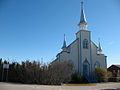
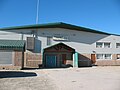
Gallery
[edit]-
 Homes and teepee
 -
 Administrative Centre
 -
-
 A Cree girl in Chisasibi
 -
 A stop sign, written inCree
 -
 Chisasibi General Store
 -
 Chisasibi Courthouse (2015)


References
[edit]- ^"Chisasibi (Cree reserved land)".Geographical Names Data Base.Natural Resources Canada.
- ^"Répertoire des municipalités:Geographic code 99055 ".www.mamh.gouv.qc.ca(in French). Ministère des Affaires municipales et de l'Habitation.
- ^abcdefgh"Census Profile, 2021 Census of Population - Profile table - Chisasibi, Terres réservées aux Cris (TC) Quebec [Census subdivision] and Chisasibi, Village cri (VC)More information: Quebec [Census subdivision]".Statistics Canada.1 February 2023.Retrieved16 January2024.
- ^ab"List of Board Council members".Retrieved15 January2024.
- ^ab"Aboriginal Canada Portal: Connectivity Profile".Archived fromthe originalon 30 August 2007.
- ^ab"Cree Nation of Chisasibi: History".Archived fromthe originalon 27 August 2009.
- ^"Cree Communities of Quebec - Chisasibi".Ottertooth.com.Retrieved16 January2024.
- ^Canada Flight Supplement.Effective 0901Z16 July 2020 to 0901Z 10 September 2020.
- ^"Waapinichikush Elementary School".Cree School Board.Retrieved16 January2024.
- ^"James Bay Eeyou School (JBES;".Cree School Board.Retrieved16 January2024.
- ^"Youth Education in Chisasibi".Retrieved16 January2024.
- ^"James Bay Eeyou School".Cree School Board. Archived fromthe originalon 23 September 2017.Retrieved23 September2017.
- ^MacLeod, Roderick; Poutanen, Mary Anne (2004)."Paths to Wisdom".A Meeting of the People: School Boards and Protestant Communities in Quebec, 1801-1998.McGill-Queen's University Press.p. 393.ISBN978-0773527423.
- ^"Chisasibi Adult Education".Cree School Board.Retrieved16 January2024.
- ^"Fort George Climate Data".World Climate.Retrieved28 September2012.
External links
[edit]| Regional county municipalities andequivalent territories |
|
|---|---|
| Municipalities | |