
Colonia del Sacramento
Colonia del Sacramento
Portuguese:Colônia do Sacramento | |
|---|---|
Capital city | |
 | |
 Colonia del Sacramento | |
| Coordinates:34°28′17″S57°50′39″W/ 34.47139°S 57.84417°W | |
| Country | |
| Department | |
| Founded | 1680 |
| Founded by | Manuel Lobo |
| Elevation | 27 m (89 ft) |
| Population (2011 Census) | |
| • Total | 26,231 |
| Time zone | UTC-3 |
| Postal code | 70000 |
| Dial plan | +598 452 (+5 digits) |
| Climate | Cfa |
| Website | https://www.colonia.gub.uy/ |
| Official name | Historic Quarter of the City of Colonia del Sacramento |
| Criteria | Cultural: iv |
| Reference | 747 |
| Inscription | 1995 (19thSession) |
| Area | 16 ha |
Colonia del Sacramento(Spanish:[koˈlonjaðelsakɾaˈmento];Portuguese:Colônia do Sacramento) is acityin southwesternUruguay,by theRío de la Plata,facingBuenos Aires,Argentina.It is one of the oldest towns in Uruguay and the capital of theColonia Department.It has a population of around 27,000.
Its historic quarter is aUNESCOWorld Heritage Site.[1]Modern Colonia del Sacramento producestextilesand has afree trade zone,in addition to apolytechniccentre and various government buildings.
History[edit]

Following therestoration of the Portuguese crown,King Peter IIsought the resolution of the southern border of Brazil.Manuel Lobowith 5 ships containing about 400 soldiers, craftsmen, carpenters and stonecutters, and 18 guns, reachedSan Gabriel Islandon 20 January 1680. On 28 January, they commenced establishing a post.[2]
José de Garrosent spies fromSanto Domingo de Sorianoon 22 February 1680, after receiving a negative response on 10 February to his ultimatum to leave the site. Garro sent a force of 3,400 men under the command of Antonio de Vera Mujica, capturing the besieged town on the night of 6–7 August 1680. Lobo was taken as a prisoner to Buenos Aires, where he died on 7 January 1683. A treaty between Spain and Portugal signed in 1681 returned Colonia to Portugal.[2]: 105–106, 109
Field Marshal Duarte Teixeira Chaves arrived off the San Gabriel islands on 25 January 1683, and commenced to rebuild the settlement. Field Marshal Cristóvão Dornelas Abreu was its governor until 1690, when Dom Francisco Naper de Lencastre took over. Smuggling, andcattle huntingfrom theBanda Oriental,were the main components of the colony's economy. Lencastre ordered the building of houses of stone and mud with tile roofs, the enlargement of the city walls, and the addition of a fortified tower. The colonists grew wheat, hemp flax, and grape vines, and exported cattle hides to Rio de Janeiro, while importing wood and foodstuffs. Sebastião da Veiga Cabral took over as governor in 1699.[2]: 113–115, 121–127, 131
As a consequence of theWar of the Spanish Succession,the governor of Buenos Aires, Valdes Incian, initiated theSiege of Colonia del Sacramento.The forces of the Spanish governor were commanded byBaltazar García Rosfrom 18 October 1704 until 14 March 1705, when the colonists were evacuated by Portuguese ships. Only the churches and bridge remained undestroyed.[2]: 135–136, 142
The colony was given back to Portugal in theTreaty of Utrecht.Manuel Gomes Barbosa took possession on 10 February 1718 with 1,040 colonists. More colonists arrived in 1721. Antonio Pedro de Vasconcellos took over as governor on 14 March 1722 and transformed it into the richest and best-defended city in theRio de la Plataregion. This included the coastalbastionsof São Pedro de Alcântara, São Miguel, Santo António, São João, Carmo, and Santa Rita.[2]: 147–160, 166, 169
Another attackduring theSpanish–Portuguese War (1735–1737),failed. Don Luis Garcia de Bivar took over as governor in 1749, but died on 5 March 1760. During that time, theTreaty of Madrid (13 January 1750)was never complied with and was finally considerednull and void.Brigadier Vicente da Silva da Fonseca then took over as governor. Fonseca was forced to surrender the colony toPedro Antonio de Cevalloson 11 October 1762. Spain returned the colony in the 1762 Treaty of Fontainebleau, and Dom José Pedro de Figueiredo Sarmento took over as governor on 27 December 1763. He was replaced by Francisco José da Rocha on 15 March 1777.[2]: 170–175, 177–178, 187, 195, 202–203
With theTreaty of San Ildefonsoin 1777, the colony became a Spanish possession once more.[2]: 206–207
It then transferred to Portuguese control again, being later incorporated intoBrazilafter 1816, when the entireBanda Oriental(Uruguay) was seized by the government of theUnited Kingdom of Portugal, Brazil and the Algarvesand renamed theCisplatina province.
On 10 January 1809, before the independence of Uruguay, it was designated as a "Vila" ( "town" in 19th century Portuguese) and has since been elevated to the status of "Ciudad" ( "city" in Spanish).
Since independence, Colonia del Sacramento has expanded to the north and east, but the originalBairro Histórico(historic quarter in Portuguese orBarrio Histórico,current Spanish spelling) retains its irregular, terrain-fitting street plan built by the Portuguese, contrasting with the wider, orthogonalcallesin the newer Spanish area.
In 2022, it was confirmed Uruguay planned to create aSilicon Valley-style new city in Colonia called Colonia Ala Este, to enticeArgentineimmigrants due to Argentina's poor economic situation. This would double Colonia's population to about 60,000 people. With an initial investment of more than US$100 million, it was planned to build a sustainable city open to the community as a hub for the knowledge economy industry on a 500-hectare site, which includes forests and seven kilometers of coastline, with beaches such as Calabrés and Fernando.[3]
Timeline of rule[edit]
The rule from 1680 to present (with flag of the period) is:
| From | To | Rule | Reason for Handover |
|---|---|---|---|
| 1680 | 1680 | conquered byJosé de Garro | |
| 1680 | 1681 | treaty between Spain and Portugal | |
| 1681 | 1705 | conquered in theWar of Spanish Succession | |
| 1705 | 1713 | Treaty of Utrecht | |
| 1714 | 1762 | First Cevallos expedition | |
| 1762 | 1763 | Treaty of Paris (1763) | |
| 1763 | 1777 | Second Cevallos expedition | |
| 1777 | 1811 | Revolt led byJosé Gervasio Artigas | |
| 1811 | 1817 | Portuguese conquest | |
| 1817 | 1822 | Brazilian Declaration of Independence | |
| 1822 | 1828 | Cisplatine War | |
| 1828 | present |
Population[edit]
In 2011 Colonia del Sacramento had a population of 26,231.[4]
| Year | Population |
|---|---|
| 1908 | 8,021 |
| 1963 | 12,846 |
| 1975 | 17,046 |
| 1985 | 19,102 |
| 1996 | 22,200 |
| 2004 | 21,714 |
| 2011 | 26,231 |
Source:Instituto Nacional de Estadística de Uruguay[5]
Geography[edit]
Climate[edit]
Colonia del Sacramento has a mildhumid subtropical climate,described by theKöppen climate classificationasCfa.Summers are warm and winters are cool, with relatively frequentfrostsandfog.The precipitation is evenly distributed throughout the year, with an average of 1,039 mm (40.91 in), and the annual average temperature is 17 °C (63 °F).
| Climate data for Colonia del Sacramento, Uruguay (1991–2020, extremes 1940–2020) | |||||||||||||
|---|---|---|---|---|---|---|---|---|---|---|---|---|---|
| Month | Jan | Feb | Mar | Apr | May | Jun | Jul | Aug | Sep | Oct | Nov | Dec | Year |
| Record high °C (°F) | 39.7 (103.5) |
37.4 (99.3) |
36.8 (98.2) |
34.6 (94.3) |
30.8 (87.4) |
36.0 (96.8) |
29.0 (84.2) |
35.0 (95.0) |
32.8 (91.0) |
36.4 (97.5) |
38.0 (100.4) |
38.7 (101.7) |
39.7 (103.5) |
| Mean daily maximum °C (°F) | 28.7 (83.7) |
27.6 (81.7) |
25.8 (78.4) |
22.4 (72.3) |
18.7 (65.7) |
15.6 (60.1) |
14.6 (58.3) |
16.9 (62.4) |
18.6 (65.5) |
21.4 (70.5) |
24.6 (76.3) |
27.4 (81.3) |
21.9 (71.4) |
| Daily mean °C (°F) | 23.7 (74.7) |
23.0 (73.4) |
21.4 (70.5) |
18.3 (64.9) |
14.9 (58.8) |
12.0 (53.6) |
11.0 (51.8) |
12.7 (54.9) |
14.3 (57.7) |
16.9 (62.4) |
19.7 (67.5) |
22.3 (72.1) |
17.5 (63.5) |
| Mean daily minimum °C (°F) | 18.8 (65.8) |
18.5 (65.3) |
17.0 (62.6) |
14.1 (57.4) |
11.2 (52.2) |
8.3 (46.9) |
7.3 (45.1) |
8.5 (47.3) |
9.9 (49.8) |
12.6 (54.7) |
14.9 (58.8) |
17.3 (63.1) |
13.2 (55.8) |
| Record low °C (°F) | 10.4 (50.7) |
9.9 (49.8) |
7.9 (46.2) |
4.4 (39.9) |
1.1 (34.0) |
−0.4 (31.3) |
−3.0 (26.6) |
−0.2 (31.6) |
1.5 (34.7) |
2.7 (36.9) |
5.3 (41.5) |
7.6 (45.7) |
−3.0 (26.6) |
| Averageprecipitationmm (inches) | 100.5 (3.96) |
111.1 (4.37) |
125.8 (4.95) |
100.6 (3.96) |
82.5 (3.25) |
68.8 (2.71) |
75.8 (2.98) |
68.9 (2.71) |
78.3 (3.08) |
112.9 (4.44) |
103.5 (4.07) |
115.8 (4.56) |
1,144.5 (45.06) |
| Average precipitation days(≥ 1.0 mm) | 6 | 6 | 7 | 7 | 6 | 5 | 5 | 6 | 6 | 7 | 7 | 7 | 75 |
| Averagerelative humidity(%) | 66 | 70 | 73 | 74 | 75 | 77 | 76 | 73 | 71 | 71 | 68 | 66 | 72 |
| Mean monthlysunshine hours | 288.3 | 237.3 | 235.6 | 180.0 | 167.4 | 132.0 | 151.9 | 179.8 | 198.0 | 223.2 | 240.0 | 272.8 | 2,506.3 |
| Mean dailysunshine hours | 9.3 | 8.4 | 7.6 | 6.0 | 5.4 | 4.4 | 4.9 | 5.8 | 6.6 | 7.2 | 8.0 | 8.8 | 6.8 |
| Source 1:Instituto Uruguayo de Metereología[6][7] | |||||||||||||
| Source 2:NOAA(precipitation 1991–2020)[8]Instituto Nacional de Investigación Agropecuaria (sun and humidity 1980–2009)[9] | |||||||||||||
Urban fabric[edit]
The city was developed on a peninsula that protrudes into theRío de la Plata.The 16-hectare "Barrio Histórico", or Portuguese Old City, was enclosed by a fortification wall across the peninsula in the site of present-day Calle Ituzaingó. Most of the fortification wall was removed in 1777 and some remaining parts again in 1859. The Portuguese part of the city has an irregular street network.[citation needed]
Outside the wall, the historical part of the city was planned in the Spanish colonial style and in the characteristic checkerboard layout.
Sport[edit]
The local professionalfootballteam isPlaza Colonia,founded in 1917, playing at theEstadio Profesor Alberto Suppici.They won the2016 Clausura,their biggest success to date.
Deportivo Colonia,founded in 1999, lost its professional status in 2007. They play at theEstadio Miguel Campomar.
Club Atlético Plazahasfutsal,volleyballandbasketballsections, as well as a football section based atEstadio Néstor Naviliat.
The town'sPlaza de toros Real de San Carlosis a disusedbullringwhich has been renovated and repurposed as a performing arts venue.
Points of interest[edit]
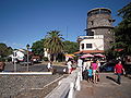
TheBarrio Histórico(historic quarter) section of Colonia del Sacramento is designated aWorld Heritage SitebyUNESCO.It has some cobblestone streets built by the Portuguese in the 17th century, and is within walking distance of the town's ferry terminal. Among the tourist attractions around the tree-linedPlaza Mayor(main square) are:
- Portón de Campo– the City Gate and wooden drawbridge
- Lighthouse and convent ruins of the 17th-century Convent of San Francisco
- Basílica del Santísimo Sacramento– the Basilica of the Holy Sacrament, built of stone by the Portuguese in 1808
- Portuguese Museum – constructed in the 18th century, it exhibits Portuguese furnishings, jewelry, uniforms and old maps of Portuguese naval expeditions
- Casa de Nacarello– an 18th-century Portuguese house
- Calle de los Suspiros,a historical street
- Municipal Museum – rebuilt by the Spanish in 1835 as theCasa del Almirante Brown,it exhibits artifacts and documents of the city's different periods and cultures
- Viceroy's House – theCasa del Virrey,reconstructed from the original ruins
- Plaza de toros Real de San Carlos,a Bullring included in an old tourist complex now abandoned.
Gallery[edit]
- Views of theBarrio Histórico
-
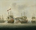 The Portuguese led attack on Nova Colonia, 6 January 1763
 -
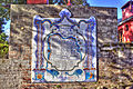 Map of the Old City in ceramic tiles
 -
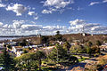 View of the historic district from the top of the lighthouse
 -
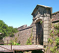 Portón de Campo, the City Gate
 -
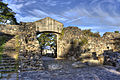 Another view of the City Gate
 -
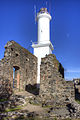 Lighthouse at Colonia del Sacramento
 -
 Calle San Pedro, a typical street in the historic district
 -
 The 1866 Wharf of Colonia
 -
 The water front
 -
 Old car parked on Calle Real in the historic district
 -
 Night at the historic quarter district - "Misiones de los Tapes" Street
 -
 The Buquebus seen from the Paseo San Gabriel
 -
 Restaurant on a corner
 -
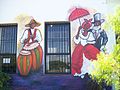 Wall art in Colonia del Sacramento
 -
 Remains of PortugueseAzulejo


Transportation[edit]
Colonia del Sacramento is served by three ferry boat lines from Buenos Aires, Argentina: "Buquebus", "Seacat Colonia" and "Colonia Express".[citation needed]
Two principal highways end in Colonia:Route 1connects Colonia toMontevideoand points east; Route 21 connects to points north, including theAarón de Anchorena National Park,30 kilometres (19 mi) distant, andFray Bentos.There is also a local airport for small planes. There is a project in process to lengthen the runway and begin commercial flights to Buenos Aires (this was done in the past) and other cities within Uruguay.
The city is served byLaguna de los Patos International Airportlocated 6 kilometres (4 mi) from Colonia along Route 1.
Consular representation[edit]
Argentina and Portugal both maintain a consulate in Colonia del Sacramento.[citation needed]
Twin towns – sister cities[edit]
 Antigua Guatemala,Guatemala[10]
 Guimarães,Portugal[11]
 Morón,Argentina[12]
 Olinda,Brazil[13]
- Pelotas,Brazil[14]
- Quilmes,Argentina[15]
See also[edit]
Bibliography[edit]
- Assunção, Fernando O.;Cravotto, Antonio(1996).Colonia del Sacramento, patrimonio mundial.Montevideo: UNESCO.(with prologue byFederico Mayor Zaragozaand introduction byMarta Canessa de Sanguinetti)(in Spanish)
References[edit]
- ^"21 World Heritage Sites you have probably never heard of".The Daily Telegraph.London.
- ^abcdefgMayor, Federico; de Sanguinetti, Marta Canessa; Assuncao, Fernando; Cravotto, Antonio (1996).Colonia del Sacramento.UNESCO. pp. 88, 93, 98–103.ISBN9230032956.
- ^"+Colonia: la" ciudad del futuro ", cruzando el charco".2022.RetrievedJune 30,2022.
- ^"Censos 2011 Cuadros Colonia".INE. 2012.Retrieved25 August2012.
- ^"Statistics of urban localities (1963–2004)"(PDF).INE. 2012. Archived fromthe original(PDF)on 2009-11-13.Retrieved3 September2012.
- ^"Estadísticas climatológicas: Estacion Meteorologica Colonia"(in Spanish). Instituto Uruguayo de Metereología.Retrieved16 May2023.
- ^"RECORDS METEOROLOGICOS EN EL URUGUAY"(in Spanish). Dirección Nacional de Meteorología. Archived fromthe originalon 9 June 2015.Retrieved16 May2023.
- ^"Colonia del Sacramento Climate Normals 1991–2020".World Meteorological Organization Climatological Standard Normals (1991–2020).National Oceanic and Atmospheric Administration.Archived fromthe originalon 7 August 2023.Retrieved7 August2023.
- ^Castaño, José; Giménez, Agustín; Ceroni, Mauricio; Furest, José; Aunchayna, Rossina."Caracterización Agroclimática del Uruguay 1980–2009"(PDF)(in Spanish). Instituto Nacional de Investigación Agropecuaria. Archived fromthe original(PDF)on 12 December 2018.Retrieved15 December2018.
- ^"Relaciones Bilaterales".uruguatemala.org(in Portuguese). Embajada de Uruguay en Guatemala.Retrieved2021-12-23.
- ^"Cidades".cm-guimaraes.pt(in Portuguese). Guimarães.Retrieved2021-12-23.
- ^"Ciudades Hermanas entre Argentina y Uruguay".taringa.net(in Spanish). Taringa!. 2020-05-06.Retrieved2021-12-23.
- ^"Olinda e Colônia do Sacramento tornam-se cidades irmãs".vermelho.org.br(in Portuguese). Vermelho. 2014-01-29.Retrieved2021-12-23.
- ^"Câmara institui Frente Parlamentar das Cidades-irmãs de Pelotas".pelotas.rs.leg.br(in Portuguese). Pelotas. 2019-11-06. Archived fromthe originalon 2021-12-23.Retrieved2021-12-23.
- ^"Hermanamiento y Cooperación entre la intendencia de Colonia y Quilmes".ci.gub.uy(in Spanish). Congreso de intendentes. 2014-11-12.Retrieved2021-12-23.
External links[edit]
- Article on Colonia del Sacramento, Official Portal of the Uruguayan GovernmentArchived2011-11-19 at theWayback Machine
- 360° Virtual Tours of Colonia del Sacramento - Uruguay360.com.uy
- Tourist information about Colonia del Sacramento
- Tourist guide about Colonia del Sacramento– photos, hosting and attractions of Colonia del Sacramento attractions
- Colonia del Sacramento Website
- INE map of Colonia del Sacramento
| Resorts and Landforms |
|
|---|---|
| |
Capital:Colonia del Sacramento | ||
| Towns and villages |  | |
| Sights | ||
|  | |||||||||||||||||||||||||||||||||||||||||||||||||||||||||||||||||||||||
|
| ||||||||||||||||||||||||||||||||||||||||||||||||||||||||||||||||||||||||
| ||||||||||||||||||||||||||||||||||||||||||||||||||||||||||||||||||||||||
| ||||||||||||||||||||||||||||||||||||||||||||||||||||||||||||||||||||||||
| ||||||||||||||||||||||||||||||||||||||||||||||||||||||||||||||||||||||||
| ||||||||||||||||||||||||||||||||||||||||||||||||||||||||||||||||||||||||
| ||
| International | |
|---|---|
| National | |
| Other | |
- Colonia del Sacramento
- Populated places in the Colonia Department
- Port cities and towns in Uruguay
- Río de la Plata
- Colonial Uruguay
- Former Portuguese colonies
- Portuguese colonization of the Americas
- Populated places established in 1680
- 1680 establishments in Uruguay
- 1680 establishments in the Portuguese Empire
- Portugal–Spain relations
- Tourism in Uruguay
- World Heritage Sites in Uruguay
- 1687 establishments in Portugal