
Corpus separatum(Fiume)
This articleneeds additional citations forverification.(April 2012) |
City of Fiume and its District | |||||||||
|---|---|---|---|---|---|---|---|---|---|
| 1779–1918 | |||||||||
 Flag
 Coat of arms
| |||||||||
| Motto:Indeficienter(Latin) Inexhaustible (without deficiency) | |||||||||
 Territory of the corpus separatum before 1918 | |||||||||
| Status | Corpus separatumof theKingdom of Hungary Part of theIllyrian Provinces(1809–1816) and theKingdom of Illyria(1816–1822) Part of theKingdom of Croatia(1849–1868) | ||||||||
| Capital | Fiume(Rijeka) | ||||||||
| Common languages | |||||||||
| Religion | |||||||||
| Governor | |||||||||
• 1779–1783 | József Majláth | ||||||||
• 1917–1918 | Zoltán Jekelfalussy | ||||||||
| Historical era | |||||||||
• Established[1] | 23 April 1779 | ||||||||
| 5 April – 17 October 1797 | |||||||||
| 3 October 1805 – 1806 | |||||||||
| 31 August 1848 | |||||||||
| 17 November 1868 | |||||||||
| 29 October 1918 | |||||||||
| 4 June 1920 | |||||||||
| Area | |||||||||
| 1869[2] | 19.57 km2(7.56 sq mi) | ||||||||
| 1880[2] | 19.57 km2(7.56 sq mi) | ||||||||
| 1890[3] | 19.57 km2(7.56 sq mi) | ||||||||
| 1900[4] | 21 km2(8.1 sq mi) | ||||||||
| 1910[5] | 21 km2(8.1 sq mi) | ||||||||
| Population | |||||||||
• 1869[2] | 17,884 | ||||||||
• 1880[2] | 20,981 | ||||||||
• 1890[3] | 29,494 | ||||||||
• 1900[4] | 38,057 | ||||||||
• 1910[5] | 49,608 | ||||||||
| Currency | Gulden (1779–1892) Krone (1892–1918) | ||||||||
| |||||||||
| Today part of | Croatia | ||||||||
Corpus separatum,aLatinterm meaning "separated body",refers to the status of the City ofFiume(modern Rijeka,Croatia) while given a special legal and political status different from its environment under the rule of theKingdom of Hungary.Formally known asCity of Fiume and its District(Hungarian:Fiume város és kerülete[6]), it was instituted by EmpressMaria Theresain 1779, determining the semi-autonomous status of Fiume within theHabsburg monarchyuntil thefallof theAustro-Hungarian Empirein 1918.
Origins[edit]
Maria Theresa, with her sovereign decision of 2 October 1776, gave up possession of Fiume, which for a long time was administered with the adjacent hereditaryInner Austrianfiefs of theHabsburgswithin theHoly Roman Empire,and gave it to theKingdom of Hungary,of which she was also queen, with a view of fostering trade. Since Hungary proper was some 500 kilometres (310 mi) away, the city was initially annexed to the HabsburgKingdom of Croatia,whose territory began east of the city walls. Croatia was ruled inpersonal union with Hungarysince 1102, and with it formed theLands of the Crown of Saint Stephen.
Two and a half years later, Maria Theresa, in her capacity asQueen of Hungary,by a royal rescript dated 23 April 1779, made the City of Fiume directly subject to the Hungarian Crown as acorpus separatum(that is, not as a part of Croatia, which was in apersonal unionwith Hungary). Since Fiume had to serve a similar function for Hungary as theImperial Free City of Triestedid for the Habsburg lands, the Hungarian estates (and probably the Queen) wanted to grant the City a similar degree of institutional autonomy to that already enjoyed by Trieste. According to Maria Theresa's rescript, Fiume was created acorpus separatum– that is, a political body with greater autonomy than aFree imperial cityor aHungarian county,and a territory comparable to the otherpartes adnexaeconstituting theCrown of St Stephen.The city's position was thus comparable to those of theregna:as Trieste was considered to be a crown land of the Austrian hereditary lands (Erblande), so Fiume was considered to be apars adnexato the crown.
After the royal rescript of 23 April 1779, the stage was set for all the political confrontations that were to happen in Fiume for more than a century and a half. In a sense, it can be said that all history that followed was a long footnote on how to interpret the two acts of 1776 and 1779. The act presented a precedent for the Hungarian constitutional praxis, since it was the first time that a part of the Holy Roman Empire (and a hereditary fief of the Habsburgs) was given to the Hungarian-Croatian kingdom. Therefore, since the Croatian and Hungarian estates had widely diverging interests with respect to Fiume, they produced very different interpretations of the rescript. The Croatians refused to accept the Hungarian reading of the document - they denied that the City could have been excluded from the surrounding territory, that was already framed into acomitatus.
During theNapoleonic Wars,the city was briefly part of theIllyrian Provinces,ending its status ascorpus separatum.Fiume returned to the Hungarian Crown in 1822; after theRevolution of 1848and the enactment of the AustrianMarch Constitution,the city was included in the autonomous Croatian kingdom as a seat of acomitatuswith no special autonomy.
Croatian–Hungarian Agreement[edit]
In 1868, following theAustro-Hungarian Compromise of 1867which createdAustria-Hungary,Croatia was allowed to negotiate its own settlement with Hungary. The finalCroatian–Hungarian Settlementleft the possession ofFiumeunsettled, pending future negotiations according to article 66, as it appeared in the Croatian version, while in the Hungarian version Fiume was declared aCorpus separatumdirectly connected to theLands of the Crown of Saint Stephenand therefore not falling within the domain ofCroatian autonomy within the kingdom,but within the domain of the joint Hungarian parliament and government. Understandably, each parliament signed its respective treaty, but when the two versions went toEmperorFranz Joseph Ifor signing, a piece of paper (theKriptic) containing a Croatian translation of the Hungarian claim to Fiume had been pasted over the Croatian version.[7]The settlement was defined as provisory. For a definitive settlement, an agreement from Hungary, Croatia and Fiume was necessary and was never achieved up to thedissolution of Austria-Hungaryin October 1918.
Corpus separatum (1870–1918)[edit]
The administration of the Corpus separatum was settled with the Statute given on 17 April 1872 by theHungarian Minister of the Interior.At the top of Fiume and its district (Hungarian:Fiume város és kerülete) there was theGovernorappointed directly from the King after a proposal from theHungarian Prime Minister.The Governor of Fiume was entitled to membership in theHouse of Magnates.The municipal self-rule was entrusted to aRappresentanzaof 56 members whose mandate lasted 6 years. The citizens had the right to elect their representative at theHouse of Representatives.From 1896 onwards the Hungarian Government reduced the scope of municipal autonomy that was practically ended by 1913.
Fiume and the district administered as acorpus separatumhad a total area of 21 square kilometres (8.1 sq mi) and comprised the City and three villages:
- Cosala(Italian) orKozala(Croatian)
- Drenova(Italian and Croatian)
- Plasse(Italian) orPlase(Croatian)
After 1918[edit]
The territory of Fiume after the end ofWorld War Iwas involved in a series of events that, after various military occupations (the longest lasting was the one led byGabriele D'Annunzio,also called theItalian Regency of Carnaro), saw the creation of an ephemeral successor entity in theFree State of Fiume.
The Free State existed officially 4 years, before it was militarily occupied and eventuallyannexedto theKingdom of Italyas part of theProvince of Fiumein 1924, annexation that marked the end of the historic Fiuman autonomy.
Demographics[edit]
In 1900, the corpus separatum had a population of 38,955 people and by 1910, the population increased to 49,608. According to the census taken by the Italian National Council of Fiume (Italian:Consiglio Nazionale Italiano di Fiume) in December 1918 after Italian army captured the city of Fiume, following the World War I the population dropped to 45,885. It had the following composition identified by association with linguistic communities:[8][9][10]
| Ethnicity | 1900 | 1910 | 1918 |
|---|---|---|---|
| Italian* | N/A | 23,283 (46.94%) | 28,911 (62.5%) |
| Croatian** | 7,497 (19.3%) | 15,731 (31.71%) | 9,092 (19.6%) |
| Slovene* | N/A | 3,973 (7.94%) | 1,674 (3.6%) |
| Hungarian | 2,842 (7.3%) | 3,619 (7.29%) | 4,431 (9.6%) |
| German | 1,945 (5.0%) | 2,476 (4.99%) | 1,616 (3.5%) |
| English* | N/A | 202 (0.41%) | N/A |
| Czech-Moravian* | N/A | 185 (0.37%) | N/A |
| Serbian | 55 (0.1%) | 70 (0.14%) | N/A |
| French* | N/A | 40 (0.08%) | N/A |
| Polish* | N/A | 36 (0.07%) | N/A |
| Romanian | 23 (0.0%) | 29 (0.06%) | N/A |
| Slovak | 29 (0.0%) | N/A | N/A |
| Other* | 26,564 (68.2%) | N/A | N/A |
| *1900 census does not identify linguistic groups marked with an asterisk specifically **1910 census identifies the group as Croatian-Ilyrians | |||
According to the census of 1900, the county was composed of the following religious communities:[11]
Total:
- Roman Catholic:36,104 (92.7%)
- Jewish:1,172 (3.0%)
- Greek Orthodox:703 (1.8%)
- Calvinist:423 (1.1%)
- Lutheran:261 (0.7%)
- Greek Catholic:73 (0.2%)
- Unitarian:11 (0.0%)
- Other or unknown: 208 (0.5%)
According to the census of 1910, the county was composed of the following religious communities:[11]
Total:
- Roman Catholic:45,130 (90.61%)
- Jewish:1,696 (3.41%)
- Calvinist:1,123 (2.25%)
- Greek Orthodox:995 (2.0%)
- Greek Catholic:467 (0.94%)
- Lutheran:311 (0.62%)
- Unitarian:16 (0.03%)
- Other or unknown: 68 (0.14%)
Gallery[edit]
-
 Smith & Meynier Paper Millc. 1880
 -
 The same millc. 1900
 -
 Adria Palace, the headquarters of Adria Royal Hungarian Sea Navigation Companyc. 1900
 -
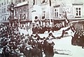 Carnival in Fiumec. 1900
 -
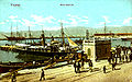
 Port of Fiumein 1909
 -
 The building of the Royal Hungarian Marine Academyc. 1900
 -
 Whitehead torpedoin 1910
 -
 Postcard depicting Szapáry Wharf and the Adria Palace
 -
 Adamich Pier in 1910
 -
 Port of Fiume in 1910


See also[edit]
Notes and references[edit]
- ^abcdef"Croatia – Fiume".worldstatesmen.org.Retrieved9 September2012.
- ^abMagyar statistikai évkönyv(in Hungarian). Budapest: Országos Magyar Királyi Statistikai Hivatal. 1893. p. 17.
- ^Jekelfalussy, József (1892).A Magyar Korona Országainak Helységnévtára(in Hungarian). Budapest: Országos Magyar Királyi Statisztikai Hivatal. p. 1126.
- ^Magyar statisztikai évkönyv(in Hungarian). Budapest: Magyar Királyi Központi Statisztikai Hivatal. 1900. p. 12.
- ^A Magyar Szent Korona Országainak Helységnévtára(in Hungarian). Budapest: Magyar Királyi Központi Statisztikai Hivatal. 1913. p. 584.
- ^See for exampleAct XIX of 1836,Act XXX of 1868,Act IX of 1901,Act XVII of 1911,Statistical Yearbooks of Hungary (1885–1910)[permanent dead link],"1910 Census of the Lands of the Crown of Saint Stephen".Retrieved9 September2012.
- ^Michael Arthur Ledeen, D'Annunzio: the first duce, p. 19.
- ^"KlimoTheca:: Könyvtár".Kt.lib.pte.hu.Retrieved2012-12-06.
- ^A.J.P. Taylor: The Habsburg Monarchy, 1809–1918, University of Chicago Press, Paperback edition, 1976,ISBN0-226-79145-9,page 269
- ^Patafta, Daniel (2004)."Promjene u nacionalnoj strukturi stanovništva grada Rijeke od 1918. do 1924. godine"[Changes in the National Structure of the Population of the City of Rijeka from 1918 to 1924].Journal of Contemporary History(in Croatian).36(2). Zagreb, Croatia: Hrvatski institut za povijest: 683–700.ISSN0590-9597.
- ^ab"KlimoTheca: Könyvtár".Kt.lib.pte.hu.Retrieved2012-12-06.
