
County Louth
County Louth
Contae Lú | |
|---|---|
 Coat of arms | |
| Nickname: The Wee County | |
| Motto(s): | |
 | |
| Country | Ireland |
| Province | Leinster |
| Region | Eastern and Midland |
| Established | 1210[1][2] |
| County town | Dundalk |
| Largest settlement | Dundalk |
| Government | |
| •Local authority | Louth County Council |
| •Dáil constituency | Louth |
| •EP constituency | Midlands–North-West |
| Area | |
| • Total | 826 km2(319 sq mi) |
| • Rank | 32nd |
| Highest elevation | 589 m (1,932 ft) |
| Population | |
| • Total | 139,100 |
| • Rank | 17th |
| • Density | 170/km2(440/sq mi) |
| Time zone | UTC±0(WET) |
| • Summer (DST) | UTC+1(IST) |
| Eircoderouting keys | A91, A92(primarily) |
| Telephone area codes | 041, 042(primarily) |
| ISO 3166 code | IE-LH |
| Vehicle index mark code | LH |
| Website | Official website |
 | |
County Louth(/laʊð/LOWDH;[4]Irish:Contae Lú)[5]is a coastalcountyin theEastern and Midland RegionofIreland,within theprovinceofLeinster.Louth is bordered by the counties ofMeathto the south,Monaghanto the west,Armaghto the north andDownto the north-east, acrossCarlingford Lough.It is thesmallest countyin Ireland by land area and the17th most populous,with just over 139,100 residentsas of 2022.[3]The county is named after the village ofLouth.Louth County Councilis thelocal authorityfor the county.[6]
History
[edit]
County Louth is named after thevillage of Louth,which in turn is named afterLugh,a god of the ancient Irish. Historically, the placename has had various spellings;Lugmad,Lughmhaigh,andLughmhadh(seeHistoric Names List,for full listing).Lúis the modernsimplified spelling.
The county is steeped in myth, legend and history, and is a setting in theTáin Bó Cúailngeepic. Later it saw the influence of theVikings,as seen in the name ofCarlingford Lough.They also established alongphortatAnnagassanin the ninth century. At this time Louth consisted of three sub-kingdoms, each subject to separate over-kingdoms:Conaille(Ulaidh);Fir Rois (Airgialla);and, theFir Arda Ciannachta (Midhe).The whole area became part of the O'Carroll Kingdom ofAirgíalla(Oriel) early in the 12th century underDonnchad Ua Cerbaill.At the same time, the area was removed from the diocese of Armagh and theepiscopal seeof theDiocese of Airgíalla or Clogherwas transferred to Louthc. 1130–1190.
A number of historic sites are in the county, including religious sites atMonasterboice,Mellifont Abbeyand theSt Mary Magdalene Dominican Friary.
TheNormansoccupied the Louth area in the 1180s, forming the County of Oriel (Uriel or Vriell) out of the O'Carroll kingdom. At this time the western boundary of occupation was unfixed andMonaghanwas still considered part of Oriel. However, over time, Louth became differentiated as 'English' Oriel, to distinguish it from the remainder ('Irish' Oriel), outside the control of the Norman colony, which had passed into the hands of theMcMahonlordship ofAirgíalla.
In the early 14th centuryEdward Brucemade claim to theHigh Kingship of Irelandand led an expeditionary force to Ireland. The Scottish army was repulsed fromDroghedabut laid waste to much of the Anglo-Norman colony of Ireland including Ardee and Dundalk. Edward was crowned on the hill of Maledon near Dundalk on 2 May 1316. His army was finally defeated and Edward was killed in theBattle of Faughartnear Dundalk, by a chiefly local force led byJohn de Bermingham.He was created 1st Earl of Louth and granted estates at Ardee on 12 May 1319 as a reward for his services to the Crown in defeating the Scots. De Bermingham was subsequently killed in theBraganstown massacreon 13 June 1329 along with some 200 members of his family and household, in a feud between the Anglo-Irish families of Louth.
One of theStatutes of Kilkennyin 1465 (5Ed. IV,cap.3) stated "That every Irishman that dwell betwixt or amongst Englishmen in the County of Dublin,Myeth,Vriell [i.e. Oriel], and Kildare... shall take to him an English surname of one town, as Sutton, Chester,Trym,Skryne,Corke, Kinsale; or colour, as white, blacke, browne; or arte or science, as smith or carpenter; or office, as cooke, butler... ". This was an attempt to compel Irish families inthe Pale,including Louth, to adopt English surnames.
In 1189, a royal charter was granted toDundalkafter a Norman nobleman namedBertram de Verdunerected a manor house at Castletown Mount. Bertram's granddaughterRoesia de Verdunlater builtCastle Rochein 1236. In 1412, a royal charter was granted to Drogheda which unified the towns of Drogheda-in-Meathand Drogheda-in-Uriel (Louth)as aCounty in its own right,styled as 'the County of the town of Drogheda'.[7]Drogheda continued as a County Borough until the setting up of County Councils, through the enactment of theLocal Government (Ireland) Act 1898,which saw all of Drogheda, including a large area south of theRiver Boyne,become part of an extended County Louth.[7][8][9]
Until the late 16th century, 1596, Louth was considered part of Ulster, before becoming part of Leinster after a conference held at Faughart between the Chiefs of Ulster (Hugh O'Neill, Earl of TyroneandHugh Roe O'Donnell), on the Irish side, and the Ulster-bornMiler Magrath,Anglican Archbishop of Cashel, andThomas Butler, 10th Earl of Ormondon that of the English. The lands ofBallymascanlan,part of the former estates ofMellifont Abbey,were transferred from Armagh to Louthc. 1630.[10]
The 16th and 17th centuries featured many skirmishes and battles involving Irish and English forces, as Louth was on the main route to 'the Moiry Pass' and the Ulster areas often in rebellion and as yet uncolonised.Oliver Cromwell attacked Drogheda in 1649slaughtering the Royalist garrison and hundreds of the town's citizens. Towards the end of the same century, the armies of the warring Kings,James IIandWilliam (III) of Orange,faced off in south Louth during the build-up to theBattle of the Boyne;the battle was fought 3 km (1.9 miles) west from Drogheda. Drogheda held for James under Lord Iveagh but surrendered to William the day after the battle of the Boyne.[citation needed]
In 1798, the leaders of theUnited Irishmenincluded Bartholomew Teeling, John Byrne, and Patrick Byrne, all from Castletown; Anthony Marmion from Louth Town and Dundalk, Anthony McCann from Corderry; Nicholas and Thomas Markey from Barmeath, and Arthur McKeown, John Warren, and James McAllister from Cambricville. They were betrayed by informers, notably a Dr Conlan, who came from Dundalk, and anagent provocateurcalled Sam Turner, from Newry. Several leaders were hanged.
TheBurning of Wildgoose Lodgetook place on the night of 29–30 October 1816, for which 18 men were executed.
The priest and scientistNicholas Callan(1799–1864), inventor of the first induction coil, was from Darver.
Geography
[edit]Louth, colloquially known as "The Wee County", is the smallest of Ireland's 32 counties by area. It is the 17th most populous county, making it the fourth most densely populated county on the island of Ireland. It is the smallest of Leinster's 12 counties in size and the 6th-largest by population. Louth is bordered by four counties –Meathto the south,Monaghanto the west,Armaghto the north, andDownto the northeast. It bounded to the east by theIrish Sea.Dundalkis the county town and is located approximately 80 km (50 mi) fromBelfastand 85 km (53 mi) fromDublin.Louth is also the northernmost county in Leinster, and the only county in the province to share a border withNorthern Ireland.
Climate
[edit]
Louth has a temperate oceanic climate (Köppen climate classificationCfb), with cool humid summers and mild winters, strongly influenced by Atlanticocean currents.Coastal areas generally experience milder winters and cooler, windier summers than inland areas. Daytime highs are generally in the 18–23 °C (64–73 °F) range throughout the county in July, with overnight lows in the 10–14 °C (50–57 °F) range. January and February are the coldest months, with average daily minimum temperatures typically falling below 2 °C (36 °F).

Met Éireann records climate data for the county from their station at Boharnamoe, ca. 1 kilometre (0.62 mi) fromArdee,in the southwest of the county. The county's record high temperature is 30.9 °C (87.6 °F), set on 12 July 1983. The coldest temperature ever recorded in Louth was on 1 January 1979, when the temperature at Ardee fell to −15.2 °C (4.6 °F). Due to the moderating influence of the Irish sea, the temperature at Ardee has only surpassed 30 °C (86 °F) once since records began in 1968. Prolonged or heavy snow is rare, but most of the county will typically experience snowfall on a few days per year.
Precipitation is evenly distributed year-round, with only about 30 mm (1.2 in) of rainfall separating the wettest months (October and November) from the driest months (March and April). There are a number of synoptic weather stations which solely record rainfall located throughout the county. The driest areas are located along the coast, with average annual rainfall atClogherheadbeing 735 mm (28.9 in), making it one of the driest locations on the island of Ireland. The wettest areas of the county are located around theCooley Mountains,with the stations atOmeath(1,118 mm (44.0 in)) and Glenmore (1,203 mm (47.4 in)) recording the most rainfall in the county.
The coastal areas of the county are particularly vulnerable to flooding and storm surges during the Winter months, and significant flood defences have been constructed along Dundalk Bay. Louth County Council's Climate Change Adaptation Strategy identified coastal and riverine flooding as the primary environmental risks to the county.
| Climate data forArdee(1989–2019, extremes 1968–present), 31 mAOD | |||||||||||||
|---|---|---|---|---|---|---|---|---|---|---|---|---|---|
| Month | Jan | Feb | Mar | Apr | May | Jun | Jul | Aug | Sep | Oct | Nov | Dec | Year |
| Record high °C (°F) | 14.7 (58.5) |
16.7 (62.1) |
21.5 (70.7) |
22.1 (71.8) |
27.2 (81.0) |
29.4 (84.9) |
30.9 (87.6) |
29.5 (85.1) |
27.1 (80.8) |
20.7 (69.3) |
17.6 (63.7) |
16.1 (61.0) |
30.9 (87.6) |
| Mean daily maximum °C (°F) | 8.3 (46.9) |
8.9 (48.0) |
10.7 (51.3) |
13.3 (55.9) |
16.1 (61.0) |
19.0 (66.2) |
20.6 (69.1) |
20.2 (68.4) |
18.1 (64.6) |
14.5 (58.1) |
10.9 (51.6) |
8.6 (47.5) |
14.1 (57.4) |
| Mean daily minimum °C (°F) | 1.9 (35.4) |
1.7 (35.1) |
2.5 (36.5) |
4.2 (39.6) |
6.6 (43.9) |
9.6 (49.3) |
11.4 (52.5) |
11.0 (51.8) |
9.2 (48.6) |
6.2 (43.2) |
3.7 (38.7) |
2.0 (35.6) |
5.8 (42.5) |
| Record low °C (°F) | −15.2 (4.6) |
−11.1 (12.0) |
−8.4 (16.9) |
−5.4 (22.3) |
−3.2 (26.2) |
−1.5 (29.3) |
1.0 (33.8) |
−1.1 (30.0) |
−3.5 (25.7) |
−5.5 (22.1) |
−8.2 (17.2) |
−11.8 (10.8) |
−15.2 (4.6) |
| Averageprecipitationmm (inches) | 74.0 (2.91) |
57.8 (2.28) |
54.1 (2.13) |
53.8 (2.12) |
61.5 (2.42) |
66.2 (2.61) |
67.0 (2.64) |
70.3 (2.77) |
63.3 (2.49) |
84.4 (3.32) |
86.7 (3.41) |
76.1 (3.00) |
815.2 (32.1) |
| Average precipitation days(≥ 1.0 mm) | 16 | 12 | 12 | 11 | 12 | 11 | 12 | 11 | 11 | 13 | 14 | 14 | 149 |
| Source:Met Éireann[11] | |||||||||||||
Demographics
[edit]Population
[edit]| Year | Pop. | ±% |
|---|---|---|
| 1821 | 119,129 | — |
| 1831 | 124,846 | +4.8% |
| 1841 | 128,240 | +2.7% |
| 1851 | 107,662 | −16.0% |
| 1861 | 90,713 | −15.7% |
| 1871 | 84,021 | −7.4% |
| 1881 | 77,684 | −7.5% |
| 1891 | 71,038 | −8.6% |
| 1901 | 65,820 | −7.3% |
| 1911 | 63,665 | −3.3% |
| 1926 | 62,739 | −1.5% |
| 1936 | 64,339 | +2.6% |
| 1946 | 66,194 | +2.9% |
| 1951 | 68,771 | +3.9% |
| 1956 | 69,194 | +0.6% |
| 1961 | 67,378 | −2.6% |
| 1966 | 69,519 | +3.2% |
| 1971 | 74,951 | +7.8% |
| 1979 | 86,135 | +14.9% |
| 1981 | 88,514 | +2.8% |
| 1986 | 91,810 | +3.7% |
| 1991 | 90,724 | −1.2% |
| 1996 | 92,166 | +1.6% |
| 2002 | 101,821 | +10.5% |
| 2006 | 111,267 | +9.3% |
| 2011 | 122,897 | +10.5% |
| 2016 | 128,884 | +4.9% |
| 2022 | 139,100 | +7.9% |
| [3][12][13][14][15][16][17][18] | ||

According to theCentral Statistics Office,139,703 people lived in County Louth as of the2022 census,a 7.9% increase since the2016 census.The population density of the county is 169.1 people per square kilometre, more than double the national average, which makes Louth the second most densely populated county in the Republic of Ireland, and the fourth most densely populated county on the island of Ireland. As of 2022, Louth was also the second most urbanised county in the State, with 69.7% of the county's population living within urban areas. Under Central Statistics Office (CSO) classification, an "urban area" is a town with a population greater than 1,500. As a result, much of the county outside of the larger towns is relatively sparsely populated, with most small areas (SAs) having a population density of between 20 and 50 people per km2.
The county has two dominant population centres,Dundalk,located in the north of the county, andDrogheda,located in the south on the border withCounty Meath.These two towns combined comprise approximately 58.9% of the county's total population, and are the 6th- and 7th-largest urban areas in Irelandrespectively. Overall, Drogheda is the larger of the two; however, the town's southern environs — home to roughly 5,000 people — are located in County Meath. Therefore, Dundalk is the largest settlement wholly located within Louth and is also the county town.
| LEA | Population |
|---|---|
| Ardee | 27,034 |
| Drogheda Rural | 19,845 |
| Drogheda Rural | 28,537 |
| Dundalk–Carlingford | 26,092 |
| Dundalk South | 38,195 |
Louth has experienced a rapid rate of population growth since the 1960s, nearly doubling in size in the fifty years between the census of 1966 and that of 2016. Its rate of growth (7.9%) since the 2016 census ranks 13th of 26 counties. The sizeable population growth in the county is influenced by its location along theDublin–Belfast corridor;with the completion of theM1 motorwayin particular driving the growth of Drogheda as a commuter town ofDublin.However, the northern areas of the county along the border withNorthern Irelandhave experienced a slight decline since 2011.[20]
In 2016, Louth surpassed its pre-famine (1841 Census) population, becoming one of only five counties in the State to do so. As of the 2022 census, 5.9 per cent of the county's population was reported as younger than 5 years old, 28.1 per cent were between 5 and 25, 51.8 per cent were between 25 and 65, and 14.2 per cent of the population was older than 65. Of this latter group, 4,591 people (3.3 per cent) were over the age of 80. The population was evenly split between females (50.68 per cent) and males (49.32 per cent).[21]
In 2021, there were 1,677 births within the county, and the average age of a first time mother was 30.5.[22]
Urban areas
[edit]The most populous towns in Louth as of the 2022 census were (population in parentheses):
| Drogheda (44,135)[a] |
Dundalk (43,112) |
Ardee (5,478) |
Clogherhead (2,275) |
Dunleer (2,143) |
Termonfeckin (1,983) |
Tullyallen (1,697) |
Carlingford (1,528) |
| Dromiskin (1,292) |
Castlebellingham (1,232) |
Collon (864) |
Omeath (778) |
Knockbridge (759) |
Louth (717) |
Tallanstown (668) |
Tinure (530) |


Ethnicity and migration
[edit]As of the 2022 census, the population of County Louth was 85.9% white. Those who identified as White Irish constituted 76.7% of the county's population, andIrish Travellerscomprised a further 0.7%. Caucasians who did not identify as ethnically Irish accounted for 8.5% of the population.[23]
The second largest ethnic group in Louth in 2022 was black, accounting for 3.3% of the population. Of this group, virtually the entire population lived in the two largest towns, with 56.5% of Louth's black residents living in Dundalk and 36.2% living in Drogheda.[24]
Those of Asian and Mixed Race backgrounds accounted for 2.7% (3,808 people) and 1.7% (2,333 people) of the population respectively, with the majority of these groups residing in either Drogheda or Dundalk. Around 9,000 people or 6.4% of the population did not state their ethnicity in 2022, a significant increase from 2.5% in the 2016 census.[25]
| Racial Composition | 2022 Census | Percentage | 2016 Census | Percentage |
|---|---|---|---|---|
| White | 119,101 | 85.9% | 116,813 | 91.5% |
| Black | 4,547 | 3.3% | 3,567 | 2.8% |
| Asian | 3,808 | 2.7% | 2,399 | 1.9% |
| Others including mixed | 2,333 | 1.7% | 1,756 | 1.4% |
| Not stated | 8,918 | 6.4% | 3,176 | 2.5% |
In contrast to the other counties in theMid-East Region,which are characterised by widespread migration fromDublin,Louth has one of the highest proportions of native residents in Ireland. Around two-thirds (64.5%) of Louth's residents were born within the county, making it the 7th most indigenous county in the State. People from elsewhere in the Republic of Ireland accounted for just 13.9% of Louth's population in 2022, compared with 49.2% in neighbouringMeathto the south. A total of 30,145 people (21.7%) were born outside of the country, up from 24,509 people (19.2%) in 2016.[26]
The largest foreign national groups by citizenship in Louth are:British(1.69%),Polish(1.50 percent),Lithuanian(1.40 percent),Nigerian(0.97 percent),Latvian(0.89 percent) andRomanian(0.57 percent).[27]
Irish language
[edit]TheCooley Peninsulawas the lastGaeltachtoutpost in Leinster. Speakers ofIrishexisted aroundOmeathand into southernArmaghup until the middle of the 20th century. The area had its own local dialect, songs, poetry and traditional customs. The dialect, known asGaeilgeOriel,is now extinct, as the last native speaker, Anne O'Hanlon, died in 1960 at the age of 89. However, extensive recordings of the dialect were made by German linguist Wilhelm Doegen for the Royal Irish Academy in 1928.[28]An Irish language college,Coláiste Bhríde,was originally established in Omeath in 1912, but later moved toRanafast,County Donegal.In 2012,Coláiste Bhrídecelebrated its 100th anniversary in Omeath, and locals were taught phrases inGaeilge Oriel.
Uniquely, the Cooley Peninsula had a sizable population ofPresbyterianGaeilgeoiríin the late 18th and 19th centuries, owing to its proximity toUlster.In 1808, Reverend William Neilson published "An introduction to the Irish language" to distribute to Presbyterian ministers in the area, as many in their congregations could not speak English.[29]
Despite its historicGaeltacht,Louth has the lowest percentage of Irish speakers of any county in the State. Just 31.8% of the population stated that they could speak any level of Irish in the 2022 census.[30]
Religion
[edit]
According to theCentral Statistics Office(CSO),[31]the Catholic Church is by far the largest religious institution in County Louth, with 100,077 members.Orthodox Christianitywas the second largest religious denomination, with 2,598 adherents. This was followed byIslamin third, with 2,281 adherents, andAnglicandenominations including theChurch of Ireland,Englandand Episcopalian in fourth, with 2,195.
The county is located within thearchdioceseofArmaghin the Roman Catholic Church, and the Archbishop of Armagh has been recognised by theVaticanas the "Primate of All Ireland"since 1353. This was replicated in the Church of Ireland following theReformation,and the ProtestantDiocese of Armaghcovers the same territorial extent as the Catholic diocese. Further, theArchbishop of Armaghalso has the title of Primate of All Ireland within the Church of Ireland.
As was the case in much of Ireland, there was a significant increase in the number of people stating that they were either non-religious oratheistin the 2022 Census. This demographic has increased by 202% in a little over a decade (2011 to 2022), from 5,485 to 16,556. People with no religion now account for 11.9% of the county's population, up from 8% in 2016.
The fastest growing religions in the county between 2016 and 2022 wereHinduism(107%), Orthodox Christianity (80%) andPantheism(78%), while the most rapidly declining religions wereLutheran(−23%),Evangelicalism(−19%),Buddhism(−13%) andApostolicorPentecostal(−11%). Although Catholicism only recorded a 4.3% decrease, the share of County Louth's residents who identified as Catholic fell sharply from 81.8% in 2016 to 72.1% in 2022.
Local government and politics
[edit]Louth County Council
[edit]The local authority is Louth County Council, which has its offices in Dundalk, and provides a number of services including planning, roads maintenance, fire brigade, council housing, water supply, waste collection, recycling and landfill, higher education grants and funding for arts and culture.[32]
As of the2019 local election,Louth has been divided into fivelocal electoral areas,whose councillors sit in three municipal districts:Ardee(which is also a municipal district), Drogheda Rural and Drogheda Rural (which form theborough district of Drogheda), and Dundalk—Carlingfordand Dundalk South (which form the municipal district ofDundalk).[33][34][35]
Freedom of the county
[edit]The following people have received thefreedomof County Louth.
Louth Dáil constituency
[edit]For elections to Dáil Éireann, Louth is represented by the five-seatDáil constituencyofLouthwhich takes all in the county of Louth, and inCounty Meath,theelectoral divisionsof Julianstown and part of St. Mary's.[37]
The Report on Dáil and European Parliament Constituencies 2007 outlined:
by extending the constituency southwards from, and in the environs of, Drogheda and taking in electoral divisions which have extensive linkages with the town. This will allow the inclusion of the town of Drogheda and hinterland areas in a single constituency.[38]
This brought the areas of the Greater Drogheda area inCounty Meathand their combined population of 20,375 into a single constituency.[39]
At the2020 general election,the constituency elected twoSinn FéinTDs (nationalist and left-wing), oneFine GaelTD (centre-right), oneLabour PartyTD (centre-left) and anIndependentTD (formerly Fine Gael).
Places of interest
[edit]- Carlingford Lough
- Cooley Peninsula
- County Museum Dundalk
- King John's Castle (Carlingford)
- Linn Duachaill
- Magdalene Tower, Drogheda
- Mellifont Abbey
- Millmount Fort
- Monasterboice
- St. Laurence's Gate
- St. Peter's Roman Catholic Church, Drogheda,where the head of St. Oliver Plunkett is housed.
People
[edit]Entertainment
[edit]- Pierce Brosnan– Actor,James Bond
- Eamonn Campbell– Member ofThe Dubliners
- Andrea Corr– Singer,The Corrs
- Caroline Corr– Musician,The Corrs
- Jim Corr– Musician,The Corrs
- Sharon Corr– Musician,The Corrs
- Evanna Lynch– Actress,Harry Potter
- Cathy Maguire– Singer/songwriter
- John Moore– Film director
- Pádraigín Ní Uallacháin,traditional Irish singer and academic.
- Gerry O'Connor– TraditionalIrish fiddleplayer
- Colin O'Donoghue– Actor,Once Upon a Time
- Emily Taaffe– Actor
Military
[edit]- James Samuel Emerson(1895–1917), British soldier and posthumous Irish recipient of theVictoria Cross,
- Patrick Anthony Langan-Byrne,British pilot, who was an Irishflying aceof theFirst World Warcredited with Ten aerial victories.
- AdmiralFrancis Leopold McClintockKCBFRS– BritishRoyal Navyofficer andExplorer
- George Martin Lees(1898–1955), British soldier, geologist and leading authority on the geology of the Middle East.
- Major-GeneralArthur Thomas MooreVC – British Soldier and Irish recipient of the Victoria Cross.
- Albert Cashier(otherwise Jennie Irene Hodgers), was born in Clogherhead and was a soldier in the Union Army during theAmerican Civil War
- Lisa Smith (soldier),a former Irish soldier who converted toIslamand later travelled toSyriaduring theSyrian Civil Warto joinIslamic State of Iraq and the Levant(ISIS).
- Anthony Coningham Sterling(1805–1871),British Armyofficer and historian, author ofThe Highland Brigade in the Crimea.
- James Sheridan (Medal of Honor),QuartermasterUnited Statesduring theAmerican Civil War– Sailor and recipient of theMedal of Honorfor action atBattle of Mobile Bay
- Hans Moore(1834–89), British Army Major who received theVictoria Crossduring theCape Frontier Wars
- William Kenny(1880–1936), British Soldier and Irish recipient of theVictoria Cross
- John BarrettCaptain ofHMS Minotaur (1793)andHMS Africa (1781)
Politics
[edit]- Dermot Ahern– Politician,Fianna FáilTDfor Louth
- Paddy O'Hanlon– Former Nationalist MP forSouth Armagh
- James Carroll– Politician,Fianna Fáil,member ofSeanad Éireannfrom Louth
- Éamonn Ceannt,Irish republican known for his role in theEaster Risingof 1916. Born Galway, raised and educated in Louth.
- Mark Dearey– Politician,Green PartySenatorfrom Louth
- Damien English– Politician, ofFine Gaelwho has served asMinister of Statesince 2014.
- John Foster, 1st Baron Oriel(1740–1828), lastSpeaker of the Irish House of Commons.
- Séamus Kirk– Politician,Fianna FáilTDfor Louth
- Tony Martin,Canadian social democratic legislator.
- John McClintock (1770–1855),MP for Athlone 1820, for County Louth 1830–31
- Brendan McGahon– Politician,Fine GaelTDfor Louth
- John McGahon,Fine GaelSenator
- Michael McKevitt– Republican dissident leader
- Arthur Morgan– Politician,Sinn FéinTDfor Louth
- T.K. Whitaker(Irish Economist)
- William Hughes,Irish-born US senator from New Jersey.
- John Atkinson,Judge and Politician, MP forLondonderry North
Sport
[edit]- Thomas Byrne– Former racing driver
- Nick Colgan– Footballer
- Kenny Finn–Irish Americansoccer and Gaelic football player
- Beatrice Hill-Lowe– Archer
- Gary Kelly– Footballer,Leeds United
- Robert Kearney– Irish Rugby player
- Colin Larkin– footballer,Hartlepool United
- Tommy Smyth– Football commentator forESPN
- Steve Staunton– Footballer
- Kevin Thornton– Footballer
- Ian Harte– Footballer
Misc
[edit]- Fr Nicholas Joseph Callan,priest and scientist best known for his work on the induction coil.
- George Drumgoole Coleman– Civil architect
- Dorothy Macardle,historian.
- Matthew O'Neill, 1st Baron Dungannon,aliasMatthew Kelly, (1520–1558), born in Dundalk. Father ofHugh O'Neill, Earl of Tyrone.
- Katherine Plunket,(1820–1932), was an Irish aristocrat from Ballymascanlan, County Louth, a prolific botanical illustrator and formerly the oldest person ever to be born and die in Ireland, at 111 years and 327 days.
- Nano Reid,artist.
- Peter Rice–Structural engineer.
- Alexander Williams,artist. Born in Monaghan, raised and educated in Louth.
Gallery
[edit]-
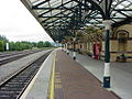 Dundalk railway station
 -
 Dundalk IT.
 -
-
 Castle Roche
 -
 Slive Foy andKing John's Castle
 -
 Mellifont Abbey
 -
 Dromiskin Round Tower
 -
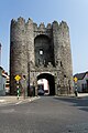 Drogheda, St. Laurences Gate
 -

-
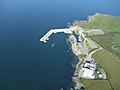 Clogherhead Harbour
 -
 Carlingford Harbour


See also
[edit]- List of abbeys and priories in the Republic of Ireland#County Louth
- List of castles in Ireland#County Louth
- Lord Lieutenant of Louth
- High Sheriff of Louth
- List of songs about Louth
Notes
[edit]- ^Approximately 5,000 Drogheda residents are located within the boundaries ofCounty Meath
References
[edit]- ^"Irish Chiefs and Clans in County Louth – Irish Pedigrees".www.libraryireland.com.Archivedfrom the original on 22 June 2019.Retrieved22 June2019.
- ^"County Louth, Ireland Genealogy Genealogy – FamilySearch Wiki".www.familysearch.org.Archivedfrom the original on 3 September 2021.Retrieved22 June2019.
- ^abc"Census of Population 2022 – Preliminary Results".Central Statistics Office (Ireland).23 June 2022.Retrieved26 May2023.
- ^Pointon, Graham E. (1990).BBC Pronouncing Dictionary of British Names(2nd ed.). Oxford: Oxford University Press. p.154.ISBN0-19-282745-6.
- ^"Placenames Database of Ireland".Fiontar (DCU) and The Placenames Branch (Department of Arts, Heritage and the Gaeltacht). 2008.Archivedfrom the original on 24 September 2021.Retrieved28 February2014.
- ^Section 2(1) of the Local Government Act, 2001, provides that the administrative area for which a county council is responsible is a county:http://www.environ.ie/en/LocalGovernment/LocalGovernmentAdministration/RHLegislation/FileDownLoad,1963,en.pdfArchived20 March 2012 at theWayback Machine
- ^abJohnston, L. C. (1826).History of Drogheda: from the earliest period to the present time.Drogheda. p. 37.Archivedfrom the original on 9 May 2016.Retrieved16 October2015.
- ^D'Alton, John1844,The History of Drogheda
- ^"County Louth | Beautiful Ireland".Archived fromthe originalon 30 July 2014.Retrieved15 September2014.
- ^p. 43, K. W. Nicholls, Map 45, A new history of Ireland IX: Maps, genealogies, lists. A companion to Irish History, Part II.
- ^"Ardee 1989–2019 Averages, Extremes 1968–".Archivedfrom the original on 24 June 2021.Retrieved18 June2021.
- ^"Census 2016 Sapmap Area: County Louth".Central Statistics Office.2016.Archivedfrom the original on 7 July 2018.Retrieved21 July2017.
- ^For 1653 and 1659 figures from Civil Survey Census of those years, Paper of Mr Hardinge to Royal Irish Academy 14 March 1865.
- ^"Server Error 404 – CSO – Central Statistics Office".www.cso.ie.Archivedfrom the original on 20 September 2010.Retrieved20 March2018.
- ^"HISTPOP.ORG – Home".www.histpop.org.Archived fromthe originalon 7 May 2016.
- ^NISRA – Northern Ireland Statistics and Research Agency (c) 2013Archived17 February 2012 at theWayback Machine.Nisranew.nisra.gov.uk (27 September 2010). Retrieved on 2013-07-23.
- ^Lee, J. J.(1981). "On the accuracy of thePre-famineIrish censuses ". In Goldstrom, J. M.; Clarkson, L. A. (eds.).Irish Population, Economy, and Society: Essays in Honour of the Late K. H. Connell.Oxford, England: Clarendon Press.
- ^Mokyr, Joel;Ó Gráda, Cormac(November 1984)."New Developments in Irish Population History, 1700–1850".The Economic History Review.37(4): 473–488.doi:10.1111/j.1468-0289.1984.tb00344.x.hdl:10197/1406.Archived fromthe originalon 4 December 2012.
- ^"Census 2022 Profile 1 - Population Distribution and Movement F1016 - Population".CSO.Retrieved24 May2024.
- ^"Population Estimates".CSO.Archivedfrom the original on 25 August 2021.Retrieved18 June2021.
- ^"CSO: Census 2022 Profile 1 - Population Distribution and Movement F1020 - Population".CSO.29 June 2023.Retrieved24 May2024.
- ^"CSO: Births, Deaths & Marriages - VSA16 - Births".CSO.31 October 2023.Retrieved24 May2024.
- ^"SAP2022T2T2CTY - Usually Resident Population by Ethnic or Cultural Background".CSO.Retrieved25 November2023.
- ^"Census 2022 Profile 5 - Diversity, Migration, Ethnicity, Irish Travellers & Religion F5082 - Population usually resident and present in the State".CSO.Retrieved25 May2024.
- ^"Census of Population 2016 – Profile 8 Irish Travellers, Ethnicity and Religion".CSO.Archivedfrom the original on 25 August 2021.Retrieved18 June2021.
- ^"Census 2022 Profile 1 - Population Distribution and Movement F1052 - Birthplace of Population Usually Resident and Present in the State".CSO.Retrieved25 May2024.
- ^"F5001 - Population Usually Resident and Present in the State".CSO.Retrieved29 January2024.
- ^"Doegen Records Web Project:Who was Doegen? / Why did Doegen come to Ireland?".Royal Irish Academy.Retrieved18 September2023.
- ^"Irish Language".Louth County Council.Archivedfrom the original on 31 May 2021.Retrieved18 June2021.
- ^"Profile 8 - The Irish Language and Education F8015 - Irish speakers aged 3 years and over".census.cso.ie.Retrieved29 January2024.
- ^"Census 2022 Profile 5 - Diversity, Migration, Ethnicity, Irish Travellers & Religion F5051 - Population Usually Resident and Present in the State".CSO.Retrieved24 May2024.
- ^"Services".Louth County Council.Archivedfrom the original on 30 April 2011.Retrieved31 March2011.
- ^County of Louth Local Electoral Areas and Municipal Districts Order 2018 (S.I. No. 626 of 2018). Signed on 19 December 2018. Statutory Instrument of theGovernment of Ireland.Archivedfrom the original on 2 February 2019. Retrieved fromIrish Statute Bookon 8 September 2020.
- ^County Of Louth Local Electoral Areas And Municipal Districts (Amendment) Order 2019 (S.I. No. 6 of 2019). Signed on 17 January 2019. Statutory Instrument of theGovernment of Ireland.Archivedfrom the original on 16 April 2019. Retrieved fromIrish Statute Bookon 8 September 2020.
- ^Local Government Reform Act 2014,s. 19: Municipal districts (No. 1 of 2014, s. 19). Enacted on 27 January 2014. Act of theOireachtas.Archivedfrom the original on 15 February 2020. Retrieved fromIrish Statute Bookon 5 September 2020.
- ^"Biden awarded the honorary freedom of Louth".The Argus.2 July 2016.Archivedfrom the original on 17 November 2020.Retrieved28 July2020.
- ^Electoral (Amendment) (Dáil Constituencies) Act 2017,Schedule (No. 39 of 2017, Schedule). Enacted on 23 December 2017. Act of theOireachtas.Retrieved fromIrish Statute Bookon 8 August 2021.
- ^"Report on Dáil and European Parliament Constituencies 2007"(PDF).Constituency Commission. 23 October 2007. p. 32.Archived(PDF)from the original on 19 November 2007.Retrieved31 December2022.
- ^"Archived copy"(PDF).Archived fromthe original(PDF)on 12 August 2011.Retrieved25 June2014.
{{cite web}}:CS1 maint: archived copy as title (link)
External links
[edit]- Carlingford town local site
- Drogheda Tourism – Official Site of the Drogheda Tourist Office
- Dunleer town portal
- Dunleer Parish
- Louth County Council
- Council and Democracy Maps– Maps of local electoral areas, municipal districts, and electoral divisions
- Omeath town local site
- Tallanstown Tidy Towns
- CSO Louth
Places adjacent to County Louth | ||||||||||||||||
|---|---|---|---|---|---|---|---|---|---|---|---|---|---|---|---|---|
| ||||||||||||||||
Places inCounty Louth | ||
|---|---|---|
| Towns | | |
| Villages and Townlands | ||
The counties are listed perprovince | ||
 | ||
| ||
| International | |
|---|---|
| National | |
| Geographic | |