Cove Pond
Appearance


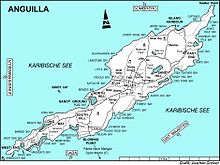
Cove Pondis a shallow 287 ha wetland at the south-western end of theCaribbeanisland ofAnguilla,aBritish Overseas Territory.It forms part of a larger coastal lagoon from which it is separated by a causeway constructed for access to theCap Julucaresort.
Important Bird Area
[edit]The wetland has been identified as anImportant Bird AreabyBirdLife Internationalbecause it provides nesting, resting, and feeding habitat for over 40 bird species, including a breeding colony ofleast ternsand winteringcommon terns.Snowyandpiping plovershave been recorded, as have thegreen-throated cariband theLesser Antillean bullfinch.[1]
References
[edit]- ^"Cove Pond".BirdLife data zone: Important Bird Areas.BirdLife International. 2012. Archived fromthe originalon July 10, 2007.Retrieved2012-11-21.
18°10′15″N63°08′13″W/ 18.17083°N 63.13694°W
