
Cucugnan
Cucugnan | |
|---|---|
 A general view of Cucugnan | |
 Coat of arms | |
Location of Cucugnan  | |
 Cucugnan  Cucugnan | |
| Coordinates:42°51′07″N2°36′11″E/ 42.8519°N 2.6031°E | |
| Country | France |
| Region | Occitania |
| Department | Aude |
| Arrondissement | Narbonne |
| Canton | Les Corbières |
| Government | |
| • Mayor(2020–2026) | André Doumenc[1] |
| Area 1 | 15.33 km2(5.92 sq mi) |
| Population (2021)[2] | 116 |
| • Density | 7.6/km2(20/sq mi) |
| Time zone | UTC+01:00(CET) |
| • Summer (DST) | UTC+02:00(CEST) |
| INSEE/Postal code | 11113/11350 |
| Elevation | 218–822 m (715–2,697 ft) (avg. 360 m or 1,180 ft) |
| 1French Land Register data, which excludes lakes, ponds, glaciers > 1 km2(0.386 sq mi or 247 acres) and river estuaries. | |
Cucugnan(French pronunciation:[kykyɲɑ̃];Occitan:Cucunhan) is acommunein theAudedepartmentin southernFrance,approximately 29.5 kilometres (18.3 mi) north-west ofPerpignan.The small village lies in a valley in theCorbières Massif,overlooked by the ruinedChâteau de Quéribus,which stands at the top of a 728-metre (2,388 ft) hill to the south of Cucugnan.[3]
History
[edit]The first documented mention of a settlement calledCucunianois a record of a gift of land fromRoger I, Count of Carcassonneto the Abbey ofLagrassein the year 951.[4]In the 13th century, during theAlbigensian Crusadeagainst theCathars,the Lord of Cucugnan participated in the Cathar resistance before he was forced to submit toKing Louis IX.In 1495, Cucugnan was destroyed by the Spanish invaders and a new village grew up around the ruined medieval village.[5]
Landmarks
[edit]The village is clustered around a small hill, at the top of which stands its main landmark, a 17th-centurywindmill,theMoulin d'Omer.The windmill was owned by the Lords of Cucugnan until theFrench Revolutionand was mentioned in historical archives dating from 1692. By the 1830s, it had fallen into ruin, but it was rebuilt and brought back into working order in a restoration project in 2003. Today the windmill is used formillingwheatand other grains for local culinary use.[6][7]
The remains of acastrumare still visible above the windmill. Adjacent to the windmill is the 14th-century church ofSaint JulienandSaint Basilissa.The church houses an unusual wooden statue of a pregnantVirgin Mary,a depiction considered controversial in traditional Catholic iconography.[6][8]
The Château de Quéribus, which lies 2.1 kilometres (1.3 mi) south-east of Cucugnan, is a notablemonument historiqueand it is sometimes regarded as the last stronghold of the followers of the Cathar faith after their defeat atMontségurin 1244. Marketed by the modern tourist industry as a "Cathar castle",Quéribus was originally built to defend the border between France andAragon.[9]The largerChâteau de Peyrepertuse,another influential citadel in the region, lies approximately 4.3 kilometres (2.7 mi) north-west of Cucugnan.
Cucugnan featured in the short story, "The Priest of Cucugnan", published in 1869 by the Parisian authorAlphonse Daudetin his collectionLetters from My Windmill,although the windmill referred to in the title is theMoulin Saint-PierreatFontvieille, Bouches-du-Rhônein theProvence-Alpes-Côte d'Azurregion. Daudet's story is based on asermonpreached in 1858 by the Abbot Ruffié which attempts to persuade the local Christian congregation to turn to a virtuous life by recounting an imaginary trip toheaven,purgatoryandhell,where the narrator finds all the old inhabitants of Cucugnan being tortured among the flames. The story reputedly originated with aNarbonnewriter, Hercules Birat, later rewritten by Achille Mir ofCarcassonne,and finally acquired and popularised by Daudet.Letters from My Windmillwas adapted as a film in 1954 byMarcel Pagnol.[6]
-
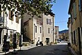 The main street in Cucugnan
 -
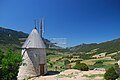 The windmill at Cucugnan
 -
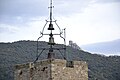 The view from Cucugnan over the church towards Quéribus Castle


Population
[edit]| Year | Pop. | ±% p.a. |
|---|---|---|
| 1968 | 124 | — |
| 1975 | 102 | −2.75% |
| 1982 | 113 | +1.47% |
| 1990 | 128 | +1.57% |
| 1999 | 113 | −1.38% |
| 2009 | 139 | +2.09% |
| 2014 | 131 | −1.18% |
| 2020 | 113 | −2.43% |
| Source: INSEE[10] | ||
See also
[edit]References
[edit]- ^"Répertoire national des élus: les maires".data.gouv.fr, Plateforme ouverte des données publiques françaises(in French). 2 December 2020.
- ^"Populations légales 2021"(in French).The National Institute of Statistics and Economic Studies.28 December 2023.
- ^Dana Facaros; Michael Pauls (2008).Languedoc-Roussillon(2nd ed.). London: Cadogan Guides. p. 10.ISBN9781860113925.
- ^Quehen, René; Dieltiens, Dominique (1983).Les châteaux cathares-- et les autres: les cinquante châteaux des Hautes-Corbières(in French). R. Quehen.
- ^"Le Village de Cucugnan".Cucugnan village website.Archivedfrom the original on 29 May 2016.Retrieved25 June2016.
- ^abcAuzias, Dominique; Labourdette, Jean-Paul (2014).Best of Aude 2014.Petit Futé. p. 148.ISBN9782746983526.
- ^"Le Moulin d'Omer".Cucugnan village website.Archivedfrom the original on 23 June 2016.Retrieved23 June2016.
- ^Wineyard, Val."Cucugnan and the Pregnant Virgins - I write about Mary Magdalene".I Write about Mary Magdalene.Archived fromthe originalon 27 May 2016.Retrieved23 June2016.
- ^Jurga, J. E. Kaufmann & H. W. Kaufmann. Ill. by Robert M. (2004).The medieval fortress: castles, forts and walled cities of the Middle Ages(1. Da Capo paperback ed.). Cambridge, Massachusetts: Da Capo Press. p. 225.ISBN9780306813580.
- ^Population en historique depuis 1968,INSEE
External links
[edit]- "Cucugnan village website"(in French).
Neighbouring areas around Cucugnan | |
|---|---|
| International | |
|---|---|
| National | |