Isla Culebra(Spanish pronunciation:[kuˈleβɾa],Snake Island) is an island,townandmunicipalityofPuerto Ricoand geographically part of theSpanish Virgin Islands.It is located approximately 17 miles (27 km) east of the Puerto Rican mainland, 12 miles (19 km) west ofSt. Thomasand 9 miles (14 km) north ofVieques.Culebra is spread over 5 barrios andCulebra Pueblo (Dewey),the main town and the administrative center of the island. Residents of the island are known as culebrenses.With a population of 1,792 as of the 2020 Census, it is Puerto Rico's least populous municipality.[3]
Originally calledIsla del PasajeandIsla de San Ildefonso,Culebra is also known asIsla Chiquita( "Little Island" ),Cuna del Sol Borincano( "Cradle of the Puerto Rican Sun" ) andÚltima Virgen( "Last Virgin", due to its position at the end of theVirgin Islandsarchipelago).
After that, the island was left abandoned for centuries. During the era of Spanish commerce through the Americas, it was used as a refuge forpirates,as well as local fishermen and sailors.[7]Some sources mention a black overseer from British-ruledTortolanamed John Stevens, who was put in charge of Culebra in the 1850s by the Governor of Vieques under theSpanish crownto protect the island from foreigners who, without proper permissions or payments of fees for despoiling Culebra, took fish, cut trees for lumber and prepared drift wood as charcoal for future sale elsewhere.[8]Appropriating the unearned title of "Captain", he began a decades-long isolated sojourn on Culebra as enforcer of Spanish interests. In October 1871, however, Stevens was found dead outside his hut, his body viciously hacked apart. His heart and entrails had been placed in clay pots, in an apparent religious ritual to curse his soul. Spanish police from Vieques tracked downTortolanforagers on Culebra who were suspected of the vicious murder. Eventually 21 of them were sentenced to forced labor on sugar plantations inViequesas punishment. The affair caused an international incident, and, to satisfy demands from theBritishambassador inMadrid,the Tortolans were finally freed by the Spanish Governor of Puerto Rico in July 1874.[9]
These events caused the government ofSwitzerlandin June 1876 to recall an expedition destined for Culebra to establish a warm-weather sanatorium there. Fearing further foreign encroachments, the Spanish government decided to populate Culebra with its own subjects.[10]
Culebra was then settled by Cayetano Escudero Sanz on October 27, 1880, when he completed his survey of the island that included subdivisions into usable lots. The Spanish government offered these parcels of land to anyone who would move to the island. The first settlers depended on rain for drinking water, as the island has no natural streams.Subsistence farmingandcattle raisingwere established and a cistern was built for common use at one end of a natural harbor orEnsenada Hondain Spanish.
This first settlement was calledSan Ildefonso,to honor the Bishop ofToledo,officiallySan Ildefonso de la Culebra.Two years later, on September 25, 1882, construction of theCulebritalighthousebegan. It was completed on February 25, 1886, which made it the oldest operating lighthouse in theCaribbeanuntil 1975, when theU.S. NavyandCoast Guardfinally closed the facility.[11]
In 1902, Culebra was integrated as a part ofVieques.One year later, on June 26,President Theodore Rooseveltestablished the Culebra Naval Reservation. A bird refuge was established on February 27, 1909.[6][7]
TheUnited States Navycited the 1900Foraker Actto expropriate the land surrounding the natural harbor and in 1902 ordered the removal of all settlers so that a base for the South Atlantic fleet could be erected. Antonio Lugo Suarez, a Puerto Rican who had made his fortune inSt. Thomasthen part of theDanish West Indiesand Pedro Márquez Morales, aSpaniardwho had married aPuerto Ricanwoman from Vieques, were successful ranchers on Culebra. Each offered an alternate site to the displaced Culebrenses, so as to prevent the total abandonment of the island. The location identified by Márquez on Playa Sardinas became the town ofDewey.[13][14]
A new church was built with materials taken from San Ildefonso and a customs office was constructed.[15]
Pedro Márquez (1850–1920) was appointed the first mayor under U.S. rule in 1905, replacing Leopoldo Padrón, the Special Delegate appointed for the transition from Spanish rule.
Pedro Márquez was succeeded as mayor in 1912 by his son, Alejandro Márquez Laureano (1912–1914) who erected the first docks for the new town and installed electric lighting on the town's streets. He was succeeded as mayor in 1914 by Claro C. Feliciano, the first mayor who had been born in Culebra.[16]
With the agreement reached with a newCubangovernment to leaseGuantanamo Bayas a naval base, in 1911 the U.S. reduced the size of its forces on Culebra and turned the installation to training purposes.[17]In 1924, the U.S. Navy began annual maneuvers on Culebra taking advantage of its deep-sea waters to practice coordinating amphibious landings on its beaches.
In 1939, theU.S. Navybegan to use the Culebra Archipelago as a gunnery and bombing practice site. This was done in preparation for the United States' involvement inWorld War II.In 1971 the people of Culebra began protests, known as theNavy-Culebra protests,for the removal of the U.S. Navy from Culebra. Four years later, in 1975, the use of Culebra as a gunnery range ceased and all operations were moved toVieques.[18]
Culebra was declared an independent island municipality in 1917. The first democratically elected government was put into place in 1960. Prior to this, the government of Puerto Rico appointed delegates to administer the island.
On September 20, 2017,Hurricane Mariastruck the island of Puerto Rico. In Culebra, whereHurricane Irmahad caused major damages a week prior, Hurricane Maria caused more destruction.[19]
Culebra is anarchipelagoconsisting of the main island and twenty-three smaller islands that lie off its coast. The largest of thesekeysare:Culebritato the east,Cayo Norteto the northeast, andCayo Luis PeñaandCayo Loboto the west. The smaller islands include Cayo Ballena, Cayos Geniqui, Arrecife Culebrita, Las Hermanas, El Mono, Cayo Lobito, Cayo Botijuela, Alcarraza, Los Gemelos, and Piedra Steven. Islands in the archipelago arearid,meaning they have no rivers orstreams.All of thefresh wateris brought from Puerto Rico via Vieques by undersea pipeline.[20]
Culebra is characterized by an irregulartopographyresulting in a long intricateshoreline.The island is approximately 7 by 5 miles (11 by 8 km). The coast is marked by cliffs, sandy coralbeachesandmangroveforests.Inland, the tallest point on the island isMount Resaca,with an elevation of 636 feet (193.9 meters),[21]followed by Balcón Hill, with an elevation of 545 feet (166.1 meters).[22]
Ensenada Hondais the largest inlet on the island and is considered to be the mosthurricanesecure harbor in the Caribbean.[23]There are also severallagoonson the island, like Corcho,Flamenco,andZoní.Culebrita Island also has a lagoon called Molino.
Culebra has no natural large mammals. However, a population ofwhite-tailed deerintroduced in July 1966 (one male and three females) can be found on the eastern region of the island.[26]
Barrios (which are, in contemporary times, roughly comparable tominor civil divisions)[33]are further subdivided into smaller areas calledsectores(sectorsin English). The types ofsectoresmay vary, from normallysectortourbanizacióntorepartotobarriadatoresidencial,among others.[34][35][36]
Culebra is a popular weekend tourist destination for mainlandPuerto Ricans,Americansand residents ofVieques.
Culebra has many beaches includingFlamenco Beach(Playa Flamenco), rated third best beach in the world for 2014 byTripAdvisor.In November 2017 Forbes rated it #19 of the top 50 beaches around the world.[37]It can be reached by shuttle buses from the ferry. The beach extends for a mile of white coral sand and is framed beautifully by arid tree-covered hills. The beach is also protected by theDepartment of Natural and Environmental Resourcesas amarine wildlife reserve.
The area west of Flamenco Beach and the adjacent Flamenco Point were used for joint-United States Navy/Marine Corpsmilitary exercises until 1975. Two oldM4 Shermantanks, which were used for target practice, can be found at the beach. Culebra andViequesoffered the U.S. military training areas for theFleet Marine Forceinamphibiousexercises forbeach landingsandnaval gunfire supporttesting. Culebra and Vieques were the two components of the Atlantic Fleet Weapons Range Inner Range. In recent years, only the shortened term "Inner Range" was used.
Coral reef on Culebra
Other beaches are only accessible by private car or boats. Of the smaller islands, onlyCulebritaandLuis Peñapermit visitors and can be accessible via water taxis from Culebra. Hiking and nature photography are encouraged on the small islands. However, activities which would disturb the nature reserves are prohibited, e.g.camping,litteringand the use ofmotor vehicles.Camping, however, is allowed on Flamenco Beach throughout the year. Reservations are recommended.[38]
Culebra is also a popular destination forscuba diversbecause of the many reefs throughout the archipelago and the crystal clear waters. Because of the "arid" nature of the island there is no run-off from rivers or streams, resulting in very clear waters around the archipelago.
To stimulate local tourism, thePuerto Rico Tourism Companylaunched theVoy Turistiendo( "I'm Touring" ) campaign, with a passport book and website. The Culebra page listsPlaya Flamenco,Faro de Culebrita,andReserva Natural del Canal Luis Peña,as places of interest.[39]
U. S. Navy ammunitions warehouse built in 1905. It is now Culebra's Historical Museum.
According to a news article byPrimera Hora,Culebra has 10 beaches.[40]
Culebra celebrates itspatron saintfestival in July. TheFiestas Patronales de Nuestra Señora del Carmenis a religious and cultural celebration
in honor ofMary, the mother of Jesusand generally features parades, games, artisans, amusement rides, regional food, and live entertainment.[20]
In 2020, the descendants of Pedro Márquez erected a plaque commemorating the centennial of his death at the original site of his butcher shop, built on the main street that bears his name.
As of 2020, the municipality has a population of 1,792, making it the least populous in Puerto Rico.[53]
10.8% of Culebra's population is of non-Hispanic origin, making it also the least Hispanic municipality in Puerto Rico. This represents an increase from 2010, when only 8.3% of the population was non-Hispanic.[54]
In 1894, written reports indicated that there were 519 residents living in five communities: San Ildefonso,Flamenco,San Isidero, Playa Sardinas I y II, and Frayle. There were 84 houses built, 24 of them in the San Ildefonso community.[44]
Pedro Morales,(1942–2019) was a Puerto Rican professional wrestler. The first Latino to hold a world heavyweight championship when he became the WWFWWEWorld Heavyweight Champion in 1971.
Avenida Hermanos Ávila Esperanza - Puerto Rico Highway 251 (PR-251)Hermanos Ávila Esperanza- Military (Andrés; Pedro; Norberto; Justino; Guillermo y Tomás) - A street inFajardo(Parcelas Beltrán) and Culebra (PR-251) is named after The Ávila Brothers. These six soldiers were honored for their exceptional work in the Korean and Vietnam wars and for returning home to Puerto Rico alive.
Like all of Puerto Rico's municipalities, the island of Culebra is administered by amayor,elected every four years in general elections. Initially, administrators were selected by theSpanish crownor by theUnited States governmentduring the 19th and early 20th century.
In 2004, Abraham Peña Nieves was elected mayor of Culebra with 50.1% of the votes.[55]He was reelected in 2008.[56]
In November 2011, Peña died ofprostate cancer.[57]The next day, it was announced that his daughter, Lizaida Peña, might replace him until the 2012 general elections.[58]However, in 2011,Ricardo López Ceperowas elected by delegates to succeed Peña. López Cepero was defeated byIván Solísin the2012 general election.
The Culebra flag consists of five vertical stripes, three alternate yellow and two green ones. The yellow central stripe has the map of Culebra in green.[62]
The field istiercedin three, in the Spanish manner,vert, argent, or.The cross and the episcopalcroziersymbolize Bishop San Ildefonso, because originally the island was calledSan Ildefonso de la Culebra.The crowned serpent (culebrameansserpent)ondoyant in paleis the emblem of its name. The mailed arm refers to the coat of the Escudero family, first settlers of the island. The laurel cross refers to the civic triumph reached when Culebra obtained the evacuation of theUnited States Navy.The crest is a coronet bearing two masts, their sails filled by the wind.[62]
Due to its size and small population, there are only three schools on Culebra, one for each level. They are the San Ildefonso Elementary School, the Antonio R. Barceló High School, and the Luis Muñoz Rivera school. Education is administered by thePuerto Rico Department of Education.
There is a small hospital in the island called Hospital de Culebra. It also offerspharmacyservices to residents and visitors. For emergencies, patients are transported by plane toFajardoon the main island.[63]
On September 20, 2020, Puerto Rico's Health Department reported that in the six months of pandemic, Culebra had reported only six cases of infection and no deaths. This was the lowest rate of infection in any municipality of Puerto Rico during theCOVID-19 infections.[64]
The island of Culebra can be reached by private boat, theCulebra Ferry,orairplane.Ferry service is available fromCeiba.Ferries make several trips a day to the main island for an approximate fare of $4.50 (round trip).[65][66]
Culebra also has a small airport,Benjamín Rivera Noriega Airport,with domestic service to the mainland andVieques.The airport is served by small airlines:
TheNavy–Culebra protestsis the name given byAmericanmediato a series of protests starting in 1971 on the island of Culebra,Puerto Ricoagainst theUnited States Navyuse of the island.[68]The protests led to the U.S. Navy abandoning its facilities on Culebra.
The historical backdrop was that in 1902, three years after the U.S. invasion of Puerto Rico, Culebra was integrated as a part ofVieques.But on June 26, 1903, U.S. PresidentTheodore Rooseveltestablished the Culebra Naval Reservation in Culebra. The suitability of Culebra and its topography for the technical requirements of naval gunfire and aircraft weapons exercises was recognized in 1936, and the Government of the United States declared Culebra and its adjacent waters as the Culebra Naval Defensive Sea Area in 1941. This military defense area included all coastal waters from high-tide elevation to three miles off shore. The naval gunnery and aircraft weapons ranges at Culebra played a considerable role, along with other gunnery facilities near Guantanamo Bay in Cuba, in the combat readiness of Allied Naval Forces during theSecond World War.These Caribbean ranges again served as primary weapons training grounds for both Naval Gunfire Support Exercises and aircraft weapons systems proficiency during the critical period of the Korean War starting in the summer of 1950. The United States Naval exercises reached a peak in 1969, as many ships and air units were attached to theAtlantic Fleetfor gunnery and aerial ordnance proficiency prior to their ultimate assignments to naval task forces stationed inSoutheast Asia.
In 1971 the people of Culebra began the protests for the removal of the U.S. Navy from Culebra. The protests were led byRuben Berrios,President of thePuerto Rican Independence Party(PIP), a well-regarded attorney in international rights, President-Honorary of theSocialist International,andLawprofessor at theUniversity of Puerto Rico.An ecumenical chapel was built onFlamenco Beach,in an action led byCatholicBishop Antulio Parilla Bonilla,Baptistminister, Luis Rivera Pagán, and George Lakey of theQuakerAction Committee.[69]Berrios and other protesterssquattedin Culebra for a few days. Some of them, including Berrios, were arrested and imprisoned forcivil disobedience.The official charge was trespassing on U.S. military territory. The protests led to the U.S. Navy discontinuing the use of Culebra as a gunnery range in 1975 and all of its operations were moved to Vieques. The case against the Navy was led byWashingtonlawyer Richard Copaken as retained pro-bono by the people of Culebra island.
The cleaning process of the island has been slow. At the end of 2016, theUnited States Army Corps of Engineerssent letters to the residents of Culebra citing active removal of undetonated explosive material still present on the island.[70]
Two British sailing ships, the brig HMSTritonand the merchantmanTopaz,are wrecked by a hurricane and come to rest with their crews on Isla Culebra in the novelGovernor Ramage R.N.byDudley Pope
^ab"Culebra Municipality".enciclopediapr.org.Fundación Puertorriqueña de las Humanidades (FPH).Archivedfrom the original on September 8, 2018.RetrievedMarch 20,2019.
^Rivera Quintero, Marcia (2014),El vuelo de la esperanza: Proyecto de las Comunidades Especiales Puerto Rico, 1997-2004(first ed.), San Juan, Puerto Rico Fundación Sila M. Calderón,ISBN978-0-9820806-1-0
^"Leyes del 2001".Lex Juris Puerto Rico(in Spanish).RetrievedJune 24,2020.
^"Coming Soon".www.campingculebra.com.Archivedfrom the original on March 22, 2018.RetrievedMarch 21,2018.
^Pasaporte: Voy Turisteando(in Spanish). Compañia de Turismo de Puerto Rico. 2021.
^"Las 1,200 playas de Puerto Rico"[The 1200 beaches of Puerto Rico].Primera Hora(in Spanish). April 14, 2017.Archivedfrom the original on December 12, 2019.RetrievedDecember 12,2019.
^United States Coast Pilot: West Indies, Porto Rico and Virgin Islands 1949 "Point Soldado, the southern point of Culebra Island, is wooded and terminates in a rocky bluff about 35 feet high. It is prominent when seen from the eastward or westward, from which directions it appears as a ridge."
^ab"CULEBRA".LexJuris (Leyes y Jurisprudencia) de Puerto Rico(in Spanish). February 19, 2020.Archivedfrom the original on February 19, 2020.RetrievedSeptember 16,2020.
^Departmento de Salud, Informe de Casos de Covid-19, 20 de septiembre de 2020.[1]For an opinion of how this came about, see, Lizmara Garcia Rivera, "Covid-19: cómo Culebra logró llegar al cero,"El Nuevo Día18 septiembre 2020.[2]
^"Culebra Bridges".National Bridge Inventory Data.U.S. Dept. of Transportation.Archivedfrom the original on February 20, 2019.RetrievedFebruary 19,2019.
Mapa de municipios y barrios - Culebra - Memoria Núm. 75(PDF).University of Puerto Rico: Estado Libre Asociado de Puerto Rico, Oficina del Gobernador, Junta de Planificacion, Santurce, Puerto Rico. 1955. Archived fromthe original(PDF)on March 6, 2023.RetrievedJanuary 1,2023.


 Flamenco Beach
 Flamenco Beach
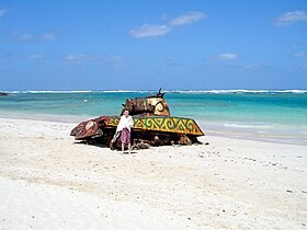 An old tank at Flamenco Beach
 Church at the town plaza
 Flamenco Beach
 Northwestern Flamenco Bay
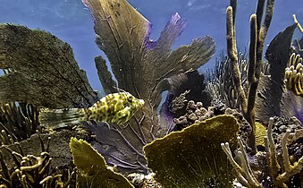 Culebra's corals
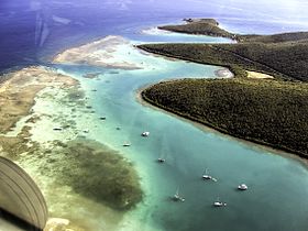 Ensenada Honda
 M4A3 Sherman tank at Flamenco Beach.
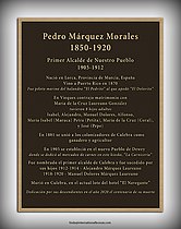 Centennial Plaque for Pedro Marquez


