
Darby, Montana
Darby, Montana | |
|---|---|
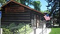
 Discovery nature trail (East side towards river) | |
 Location of Darby, Montana | |
| Coordinates:46°1′19″N114°10′47″W/ 46.02194°N 114.17972°W | |
| Country | United States |
| State | Montana |
| County | Ravalli |
| Government | |
| • Mayor | Nancy McKinney[1] |
| Area | |
| • Total | 0.65 sq mi (1.69 km2) |
| • Land | 0.63 sq mi (1.64 km2) |
| • Water | 0.02 sq mi (0.05 km2) |
| Elevation | 3,885 ft (1,184 m) |
| Population (2020) | |
| • Total | 783 |
| • Density | 1,238.92/sq mi (478.32/km2) |
| Time zone | UTC-7(Mountain (MST)) |
| • Summer (DST) | UTC-6(MDT) |
| ZIP code | 59829 |
| Area code | 406 |
| FIPS code | 30-19300 |
| GNISfeature ID | 0782081[3] |
| Website | www |
Darby(Salish:snk̓ʷɫxʷexʷem̓i,"Place Where They Would Lift Something"[4][5]) is a town inRavalli County,Montana,United States. The population was 783 at the2020 census.[6]Darby is located near the southwestern border of Montana and Idaho, along the Continental Divide.
Officially established in 1889, the town was named after James W. Darby who signed the post office application.[7]
Geography
[edit]According to theUnited States Census Bureau,the town has a total area of 0.58 square miles (1.50 km2), all land.[8]
Darby is located at the southern end of theBitterroot Valley.The valley is formed between theBitterroot Rangeon the west and the smallerSapphire Mountainson the east.
The area south of Darby is callednɫpapʔáin Salish.[4]
Climate
[edit]Thisclimaticregion is typified by large seasonal temperature differences, with warm to hot (and often humid) summers and cold (sometimes severely cold) winters. According to theKöppen Climate Classificationsystem, Darby has ahumid continental climate,abbreviated "Dfb" on climate maps.[9]
Visitors to Darby may wish to seek shelter during thunderstorms. In July 2012, "A cowboy and two spectators were taken by ambulance to aHamiltonhospital [...] after lightning hit a power pole at the Elite Bull Connection, sending an electric shock through the grandstands,rodeochutes and bull pens. "[10]On July 14, 2014, 45 cattle on a ranch near Darby were killed in a singlelightning strike.[11]
| Climate data for Darby, Montana (1991–2020 normals, extremes 1898–1899, 1914, 1926–present) | |||||||||||||
|---|---|---|---|---|---|---|---|---|---|---|---|---|---|
| Month | Jan | Feb | Mar | Apr | May | Jun | Jul | Aug | Sep | Oct | Nov | Dec | Year |
| Record high °F (°C) | 69 (21) |
70 (21) |
78 (26) |
85 (29) |
95 (35) |
100 (38) |
105 (41) |
103 (39) |
98 (37) |
91 (33) |
74 (23) |
67 (19) |
105 (41) |
| Mean daily maximum °F (°C) | 33.9 (1.1) |
38.1 (3.4) |
47.2 (8.4) |
53.7 (12.1) |
64.0 (17.8) |
71.6 (22.0) |
81.8 (27.7) |
80.6 (27.0) |
71.4 (21.9) |
57.0 (13.9) |
41.6 (5.3) |
32.2 (0.1) |
56.1 (13.4) |
| Daily mean °F (°C) | 26.5 (−3.1) |
29.5 (−1.4) |
37.1 (2.8) |
42.5 (5.8) |
51.5 (10.8) |
58.0 (14.4) |
65.7 (18.7) |
64.1 (17.8) |
56.4 (13.6) |
44.8 (7.1) |
33.2 (0.7) |
25.7 (−3.5) |
44.6 (7.0) |
| Mean daily minimum °F (°C) | 19.2 (−7.1) |
21.0 (−6.1) |
27.1 (−2.7) |
31.3 (−0.4) |
39.0 (3.9) |
44.5 (6.9) |
49.6 (9.8) |
47.6 (8.7) |
41.5 (5.3) |
32.6 (0.3) |
24.8 (−4.0) |
19.2 (−7.1) |
33.1 (0.6) |
| Record low °F (°C) | −36 (−38) |
−35 (−37) |
−15 (−26) |
2 (−17) |
17 (−8) |
25 (−4) |
31 (−1) |
25 (−4) |
14 (−10) |
−5 (−21) |
−25 (−32) |
−34 (−37) |
−36 (−38) |
| Averageprecipitationinches (mm) | 1.08 (27) |
0.87 (22) |
0.85 (22) |
1.04 (26) |
1.60 (41) |
2.09 (53) |
1.14 (29) |
0.90 (23) |
1.23 (31) |
1.50 (38) |
1.55 (39) |
1.26 (32) |
15.11 (384) |
| Average precipitation days(≥ 0.01 in) | 8.4 | 5.6 | 6.4 | 6.9 | 9.2 | 9.6 | 5.6 | 5.6 | 6.1 | 8.3 | 7.9 | 7.7 | 87.3 |
| Source:NOAA[12][13] | |||||||||||||
Demographics
[edit]| Census | Pop. | Note | %± |
|---|---|---|---|
| 1920 | 325 | — | |
| 1930 | 285 | −12.3% | |
| 1940 | 481 | 68.8% | |
| 1950 | 415 | −13.7% | |
| 1960 | 398 | −4.1% | |
| 1970 | 538 | 35.2% | |
| 1980 | 581 | 8.0% | |
| 1990 | 625 | 7.6% | |
| 2000 | 710 | 13.6% | |
| 2010 | 720 | 1.4% | |
| 2020 | 783 | 8.8% | |
| U.S. Decennial Census[14][6] | |||
2010 census
[edit]As of thecensus[15]of 2010, there were 720 people, 303 households, and 179 families residing in the town. Thepopulation densitywas 1,241.4 inhabitants per square mile (479.3/km2). There were 360 housing units at an average density of 620.7 per square mile (239.7/km2). The racial makeup of the town was 91.3%White,0.1%African American,4.2%Native American,0.8%Asian,and 3.6% from two or more races.HispanicorLatinoof any race were 2.2% of the population.
There were 303 households, of which 28.1% had children under the age of 18 living with them, 39.6% weremarried couplesliving together, 14.5% had a female householder with no husband present, 5.0% had a male householder with no wife present, and 40.9% were non-families. 33.3% of all households were made up of individuals, and 12.9% had someone living alone who was 65 years of age or older. The average household size was 2.36 and the average family size was 2.94.
The median age in the town was 40.8 years. 24% of residents were under the age of 18; 8.2% were between the ages of 18 and 24; 23.1% were from 25 to 44; 29.6% were from 45 to 64; and 15% were 65 years of age or older. The gender makeup of the town was 49.9% male and 50.1% female.
2000 census
[edit]As of thecensus[16]of 2000, there were 710 people, 279 households, and 176 families residing in the town. The population density was 1,336.5 inhabitants per square mile (516.0/km2). There were 316 housing units at an average density of 230.2/km2or 594.8/sq mi. The racial makeup of the town was 90.56%White,0.14%African American,3.24%Native American,2.39% fromother races,and 3.66% from two or more races.HispanicorLatinoof any race were 3.52% of the population.
There were 279 households, out of which 36.9% had children under the age of 18 living with them, 41.9% weremarried couplesliving together, 14.0% had a female householder with no husband present, and 36.9% were non-families. 30.5% of all households were made up of individuals, and 10.8% had someone living alone who was 65 years of age or older. The average household size was 2.54 and the average family size was 3.20.
In the town, the population was spread out, with 32.3% under the age of 18, 9.0% from 18 to 24, 26.9% from 25 to 44, 22.5% from 45 to 64, and 9.3% who were 65 years of age or older. The median age was 33 years. For every 100 females there were 99.4 males. For every 100 females age 18 and over, there were 91.6 males.
The median income for a household in the town was $25,221, and the median income for a family was $27,500. Males had a median income of $21,071 versus $20,781 for females. Theper capita incomefor the town was $11,658. About 19.5% of families and 24.0% of the population were below thepoverty line,including 30.6% of those under age 18 and 9.3% of those age 65 or over.
Arts and culture
[edit]The Darby Pioneer Memorial Museum has an extensive collection of pioneer artifacts.[17]The Darby Ranger Station Museum showcases information about thestationand the people who worked there. In addition it serves as a Visitor Center.[18]
The town has an assortment of annual events. In January the Bitterroot Mushers hold the Darby Dog Derby. The event has multipledog sledraces with a variety of distances.[19]During summer the town enjoys Last Fridays at the Main Street Park, which has live music, art, and vendors.[20]In July, the community celebrates with the Strawberry Festival, a fundraiser for the fire department.[21]Strawberry shortcake is served and live bluegrass music is shared in the afternoon. There is also the Hardtimes Bluegrass Festival held north of town. In 2023 thirteen bands performed.[22]
The Darby Rodeo Association sponsors severalrodeosduring the year.[23]The Yellowstone Darby Xtreme Bareback Event is aPRCAsanctioned event. The Twisted Nut festival in July is used as a fundraiser for testicular cancer.[24]
Darby Community Public Library serves the town.[25]
Parks and recreation
[edit]The town has five city parks, plus a skatepark and trail system.[26]The Darby Skatepark was built by Evergreen Skateparks, an award-winning international company.[27]Several hiking trails have trailheads near Darby.[28]
TheBitterroot Riverdirectly next to town is particularly known forfly fishing.The town is near both the West Fork and East Fork parts of the river, offering variety in fishing options. At only 7 miles (11 km) away,Lake Comooffers fishing, kayaking, and hiking. The picturesque lake is in theBitterroot National Forest.[29]NearbyPainted Rocks State Parkhas areservoirwith boating and camping available.[30]
South of Darby isLost Trail Powder Mountainwhich is used for both downhill skiing and snowboarding.
Government
[edit]Darby has a mayor-council form of government. The Darby Town Council has two wards and an at-large position.[31]In 2023, the Mayor was Nancy McKinney.[1]
Education
[edit]Darby School District educates students from kindergarten through 12th grade.[32]There are three schools in the district, elementary, middle for grades 7 and 8, and high school. In 2022, there were 349 students.[33]Darby High School's team name is the Tigers.[34]
Media
[edit]TheRavalli Republicnewspaper is published in nearby Hamilton and covers Darby news.
The FM radio stationKHDVis licensed in Darby.[35]It airs a classic hits music format.
Television filmed in Darby
[edit]Yellowstoneis an American television series created byTaylor Sheridanthat premiered on June 20, 2018, on theParamount Network.The series went into production in August 2017 at theChief JosephRanch, which stands in as the home of character John Dutton.[36]
Infrastructure
[edit]US Route 93passes through town from north to south.
The nearest commercial airport isMissoula Montana Airport,63 miles (101 km) north.
In 2023, Bitterroot Health began construction on a clinic in Darby.[37]Other healthcare facilities are in Hamilton or Missoula.
Scenic Community Gallery
[edit]-
 Fishing north of Darby (Lost Horse)
 -
 Main street park
 -
 Veterans Memorial at Loggers Day field
 -
 Pioneer Memorial Museum
 -
 District Library
 -
 Community clubhouse
 -
 Discovery nature trail (West side near Rodeo grounds)
 -
 Discovery nature trail (East side towards river)
 -
 Richard Cromwell Memorial Rodeo Grounds
 -
 Tennis courts next to school
 -
 Town Hall (Tanner Ave and Hwy 93)


See also
[edit]References
[edit]- ^ab"Office of the Mayor".Town of Darby.RetrievedSeptember 25,2023.
- ^"ArcGIS REST Services Directory".United States Census Bureau.RetrievedSeptember 5,2022.
- ^abU.S. Geological Survey Geographic Names Information System: Darby, Montana
- ^abTachini, Pete; Louie Adams, Sophie Mays, Mary Lucy Parker, Johnny Arlee, Frances Vanderburg, Lucy Vanderburg, Diana Christopher-Cote (1998).nyoʻnuntn q̓éymin, Flathead Nation Salish dictionary.Pablo, MT: Bilingual Education Department, Salish Kootenai College. p. 36.
{{cite book}}:CS1 maint: multiple names: authors list (link) - ^"Salish Audio Files".Salish-Pend d'Oreille Culture Committee.2014.RetrievedJune 28,2014.
- ^ab"U.S. Census website".United States Census Bureau.RetrievedNovember 2,2021.
- ^"Darby".Montana Place Names Companion.Montana Historical Society.RetrievedApril 2,2021.
- ^"US Gazetteer files 2010".United States Census Bureau.Archived fromthe originalon July 2, 2012.RetrievedDecember 18,2012.
- ^Climate Summary for Darby, Montana
- ^Devlin, Sherry (July 15, 2012)."3 injured when lightning hits Darby rodeo grounds".Missoulian.RetrievedJuly 24,2014.
- ^Backus, Perry (July 22, 2014)."45 cows killed by single lightning strike near Darby".Missoulian.RetrievedJuly 24,2014.
- ^"NOWData - NOAA Online Weather Data".National Oceanic and Atmospheric Administration.RetrievedDecember 13,2023.
- ^"Summary of Monthly Normals 1991-2020".National Oceanic and Atmospheric Administration.RetrievedDecember 13,2023.
- ^"Census of Population and Housing".Census.gov.RetrievedJune 4,2015.
- ^"U.S. Census website".United States Census Bureau.RetrievedDecember 18,2012.
- ^"U.S. Census website".United States Census Bureau.RetrievedJanuary 31,2008.
- ^"Darby Pioneer Memorial Museum".Montana Office of Tourism.RetrievedSeptember 25,2023.
- ^"Historic Darby Ranger Station Visitor's Center and Museum".US Forest Service.RetrievedSeptember 25,2023.
- ^"Presenting the 2022-2023 Season".Bitterroot Mushers.RetrievedSeptember 25,2023.
- ^"Annual Events".Town of Darby.RetrievedSeptember 25,2023.
- ^Mcconnaha, Michelle (July 13, 2023)."Strawberry Festival benefits Darby Fire Department".Ravalli Republic.RetrievedSeptember 25,2023.
- ^"Hardtimes Bluegrass Festival 2023".Shook Mountain Productions.RetrievedSeptember 25,2023.
- ^"Howdy".Darby Rodeo Association.RetrievedSeptember 25,2023.
- ^Abell, Jessica (June 30, 2023)."Twisted Nut Rodeo set for July 7, 8 in Darby".Ravalli Republic.RetrievedSeptember 25,2023.
- ^"Darby Community Public Library".Darby Community Public Library.RetrievedApril 12,2021.
- ^"Parks, Trails, Facilities".Town of Darby.RetrievedSeptember 25,2023.
- ^"Who we are".Evergreen Skateparks.RetrievedSeptember 25,2023.
- ^"Darby Montana Ultimate Guide".TravelMT.RetrievedSeptember 25,2023.
- ^"Lake Como".Ravalli County Tourism Business Improvement District (RCTBID).RetrievedSeptember 25,2023.
- ^"PAINTED ROCKS STATE PARK".Montana Fish, Wildlife, and Parks.RetrievedSeptember 25,2023.
- ^"Town Council".Town of Darby.Town of Darby.RetrievedAugust 9,2015.
- ^"Darby School District #9".Darby School District.RetrievedApril 12,2021.
- ^"Darby K-12 Schools".National Center for Education Statistics.RetrievedSeptember 25,2023.
- ^"Member Schools".Montana High School Association.RetrievedApril 19,2021.
- ^"KHDV".FCC.RetrievedSeptember 25,2023.
- ^Byron, Eve (December 8, 2017)."Costner hosts Bullock on the set of 'Yellowstone'".Ravalli Republic.RetrievedAugust 27,2020.
- ^"New clinic for Darby".Bitterroot Health. March 9, 2023.RetrievedSeptember 25,2023.
External links
[edit]Municipalities and communities ofRavalli County, Montana,United States | ||
|---|---|---|
| City | 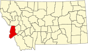 | |
| Towns | ||
| CDPs | ||
| Other communities | ||