Darling Downs
| Darling Downs Queensland | |||||||||||||||
|---|---|---|---|---|---|---|---|---|---|---|---|---|---|---|---|
 | |||||||||||||||
| Coordinates | 27°49′S151°38′E/ 27.817°S 151.633°E | ||||||||||||||
| Population | 241,537 (2010)[1] | ||||||||||||||
| • Density | 3.121089/km2(8.083583/sq mi) | ||||||||||||||
| Established | 1840 | ||||||||||||||
| Area | 77,388.7 km2(29,879.9 sq mi) | ||||||||||||||
| LGA(s) | Goondiwindi,Southern Downs,Toowoomba,Western Downs | ||||||||||||||
| State electorate(s) | Condamine,Nanango,Southern Downs,Toowoomba North,Toowoomba South,Warrego | ||||||||||||||
| Federal division(s) | Groom,Maranoa | ||||||||||||||
| |||||||||||||||
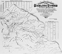
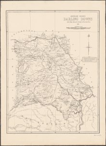
TheDarling Downsis afarmingregion on the western slopes of theGreat Dividing Rangein southernQueensland, Australia.The Downs are to the west ofSouth East Queenslandand are one of the majorregions of Queensland.The name was generally applied to an area approximating to that of theCondamine Rivercatchment upstream ofCondaminetownship but is now applied to a wider region comprising theSouthern Downs,Western Downs,ToowoombaandGoondiwindilocal authority areas.[2]The name Darling Downs was given in 1827 byAllan Cunningham,the first European explorer to reach the area and recognises the thenGovernor of New South Wales,Ralph Darling.[3]
The region has developed a strong and diverse agricultural industry largely due to the extensive areas ofvertosols(cracking clay soils), particularly black vertosols, of moderate to high fertility andavailable water capacity.[4]Manufacturing and mining, particularly coal mining are also important, and coal seam gas extraction experienced significant growth in the decade up to 2016.
Thelandscapeis dominated by rolling hills covered by pastures of many different species,vegetables,legumessuch as soy beans and chick peas, and other crops includingcotton,wheat,barleyandsorghum.Between the farmlands there are long stretches of crisscrossing roads,bushyridges, winding creeks and herds of cattle. There are farms withbeefanddairy cattle,pigs,sheepandlambstock. Other typical sights includeirrigationsystems, windmills serving aswater wellpumps to get water from theGreat Artesian Basin,light planescrop-dusting, rusty oldwoolshedsand other scattered remnants from a bygone era of early exploration and settlement.
The region is recognised as a cultural icon on the list of Queensland's Q150 icons.[5]
Geography
[edit]
The largest city and commercial centre of the Darling Downs isToowoomba[6]about 132 kilometres (82 mi) west ofBrisbane.Other towns situated on what is now called The Downs includeDalby,Warwick,Stanthorpe,Wallangarra,Goondiwindi,Oakey,Miles,Pittsworth,Allora,Clifton,Cecil Plains,Drayton,Millmerran,Nobby,andChinchilla.TheNew England Highway,Gore Highwayand theWarrego Highwaytraverse the region. TheToowoomba Second Range Crossinghas been constructed so that heavy traffic can avoid passing through Toowoomba.Coolmunda Dam,Leslie Dam,Cooby Dam,Perseverance Dam,Cressbrook Dam,Storm King Damand theGlenlyon Damare some of the major water storage facilities in the area. West of Toowoomba is theToowoomba Wellcamp Airport.


The Darling Down is situated in thedrainage basinsof theCondamine RiverandMaranoa Riverand tributaries. The Condamine River flood plain is noted for its good soils formed bybasalticalluvium.[7]On the northern boundaries of the Downs are theBunya Mountainsand theBunya Mountains National Park.The region to the north is theSouth Burnettand theMaranoalies to the west. A section of the western downs lies over coal deposits of theSurat Basin.Towards the coast, the mountains of theScenic Rimform the headwaters of the westward flowing Condamine.
Climate
[edit]The majority of the Darling Downs has ahumid subtropical climatealthough some areas experience asemi-aridorsubtropical highland climate.Summer maximum temperatures range from 28 to 34 °C (82 to 93 °F), while winter maximums range from 13 to 19 °C (55 to 66 °F). The annual rainfall ranges from 600 mm (24 in) in the far west of the region, to 1,000 mm (39 in) in the east. In the south-east of the Darling Downs winter temperatures can drop below −5 °C (23 °F) with heavyfrostand occasionalsnow,while in the north-west summer temperatures can surpass 45 °C (113 °F). Severethunderstormsand damagingfloodsare a threat at times, as arebushfiresin dry years.
Southern Downs
[edit]Part of the Darling Downs, which includes the towns of Allora, Clifton, Warwick, Killarney and the rocky district in the south known as theGranite Belt,is known as theSouthern Downs.The phrase is also used to define political boundaries and in the promotion of tourism in the area. TheDumaresqand theMacIntyreare found in this part of the region. (This is different to the IBRA subregion also known as The Southern DownsInterim Biogeographic Regionalisation for Australia,which is further west, around the towns of Roma, Mitchell and Injune).
History
[edit]

Baranggum (also known as Barrunggam, Barunggam Parrungoom, Murrumgama) is anAustralian Aboriginal languagespoken by theBaranggum people.The Baranggum language region includes the landscape within the local government boundaries of theWestern Downs Regional Council,particularlyDalby,Tara,Jandowaeand west towardsChinchilla.[8]
Originally, the Darling Downs was covered with a wealth of indigenousgrasseswhich created an ideal verdure for stock eight months of the year. The Darling Downs Aboriginals had an annual burning season at the time when the indigenous grasses were ripe and dry. The annual fires gave the local Aboriginals of the Darling Downs the name "Goonneeburra" or "Fire Blacks" – "goonnee" being a name for fire and "burra" a generic word for the whole race. This is what the Downs tribes were known as to the coastal Aborigines who inhabited theMoreton Bayarea.Murriis a wider-spread generic word meaning the whole race but in the Kamabroi dialect.[citation needed]The Downs tribes spoke one common dialect, called Waccah and so to all other surrounding tribes were known as the Wacca-burra. The Goonnee-burra were once situated where Warwick stands today. Goonnee meant "the ones who hunt with fire".[9]


Allan Cunninghamset out to explore the area to the west ofMoreton Bayin 1827, crossing to the west of theGreat Dividing Rangefrom theHunter Regionand travelling north. In June 1827, Cunningham climbed to the top of Mount Dumaresque[10](near what is now Clintonvale close toMaryvale) and after wrote in his diary that this lush area was ideal for settlement. Exploring around Mount Dumaresque, Cunningham found a pass, now known asCunninghams Gap.Cunningham returned to Moreton Bay in 1828 and withCharles Frasercharted the route through the pass to the Darling Downs.[11]Ludwig Leichhardtin 1844 saw the remains of a camp showing the signs of white men through ridge poles and steel axes.
News of the lush pastures quickly spread resulting in a land grab that authorities in the distant New South Wales colony found difficult to stop.[12]Patrick Lesliewas the first European person to settle on the Darling Downs in 1840, establishing asheepproperty atCanning Downson theCondamine Riverin 1846. Other well-established residences on the southern downs include Glengallan Homestead, Talgai Homestead, Pringle Cottage and Rosenthal Homestead. One of the first stations to be established was Jimbour House. It was also the point where Leichhardt launched his expedition to the Northern Territory in 1844.[13]
| Railway lines on the Darling Downs | ||||
|---|---|---|---|---|
| From | To | Line | Opened | Closed |
| Toowoomba | Dalby | Western | 1868 | – |
| Toowoomba | Warwick | Southern | 1871 | – |
| Toowoomba | Miles | Western | 1878 | – |
| Warwick | Stanthorpe | Southern | 1881 | – |
| Toowoomba | Cabarlah | Crows Nest | 1883 | 1961 |
| Warwick | Killarney | Killarney | 1885 | 1964 |
| Toowoomba | Crows Nest | Crows Nest | 1886 | 1961 |
| Warwick | Allora | Goomburra | 1897 | 1995 |
| Hendon | Goomburra | Goomburra | 1897 | 1995 |
| Wyreema | Millmerran | Millmerran | 1897 | – |
| Warwick | Goondiwindi | South Western | 1904 | – |
| Dalby | Bell | Bell | 1906 | 1972 |
| Kingsthorpe | Haden | Haden | 1910 | 1964 |
| Dalby | Tara | Glenmorgan | 1911 | – |
| Warwick | Maryvale | Maryvale | 1911 | 1960 |
| Oakey | Cooyar | Cooyar | 1913 | 1969 |
| Miles | Wandoan | Wandoan | 1913 | – |
| Dalby | Jandowae | Jandowae | 1914 | 2013 |
| Oakey | Cecil Plains | Cecil Plains | 1915 | 1984 |
| Cottonvale | Amiens | Amiens | 1920 | 1974 |
By 1844 there 26 properties including a number of sheep stations with more than 150,000 head.[14]Local aboriginals and Europeansquattersco-settled the area from the late 1840s onwards.[15]Darling Downs then became known as the 'jewel in the diadem of squatterdom' with an elite 'pure merino' class living in comfortable houses.[16]
In 1854,Charles Douglas Eastaughffesettled in the area.Spicers GapRoad opened up the area in the 1850s. Later the expansion ofQueensland Rail's train networks andCobb and Co'sstagecoachtransport greatly assisted access to the region.Goldwas found in the district around this time, however it was agricultural activity that provided for the boom times ahead.
The1891 Australian shearers' strikestarted atJondaryan.The Darling Downs experienced awater crisisas the Condamine River dried up during the severe drought of 1994/1995.[17]
During the early 20th century dairy was a significant industry for Queensland. The 1930s saw the peaking of the dairy industry on the Downs with 6,500 farms and over 200,000 milking cows.[7]The Downs Co-operative Dairy Association expanded, constructed or purchased at least 10 butter and cheese factories across the Darling Downs.[18]The Downs Co-operative Dairy Association Limited Factoryin Toowoomba closed in 2006.[19]
In 2010, the population of the Darling Downs was estimated to be 241,537 people.[20]
In 2022, theWieambilla police shootingstook place, marking the first fundamentalist Christian terrorist attack in Australia.
Industry
[edit]The Queensland Gas Pipeline oil pipeline and the Roma to Brisbane Pipeline, Australia's first natural gas pipeline both cross the region from west to east. There are threecoal mines,New Acland Mine,Kogan Creek MineandCameby Downs coal mineand a number of power stations situated on the Downs, including theMillmerran Power Station,Oakey Power Station,Darling Downs Power Stationand theKogan Creek Power Station.Tarong Power Stationis building the state's largest grid battery storage project.[21]TheDingo Fencestarts at the town ofJimbouracross the country to theGreat Australian Bight.Mining exploration leases cover more than 90% of the Darling Downs.[22]The western Downs has seen a massive installation ofcoal seam gaswells.[23]
After agriculture and mining and manufacturing are the next most important sectors. Manufacturing focuses on food and beverages but also the production of machinery, equipment and metal products.[24]
Agriculture
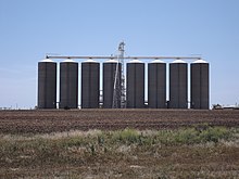
[edit]The region produces around one quarter of the state's agricultural output.[25]Water for irrigation is mostly sourced fromgroundwaterfrom alluvialaquifers.Water is also extracted from streams,off-stream reservoirsand on-farm dams.[26]The lower temperatures of the milder summers in the Stanthorpe and Killarney regions allows farmers to grow lettuce, celery, brassicas and potato.[26]
The Darling Downs contains the largest deposit of rich black agricultural soils in Australia.[22]A commonly grown grass speciesPanicum coloratum,also known as Bambatsi, is well-suited for pastures used for grazing because it is suitable to the heavy-cracking clay soils found in the area.[27]The eastern Downs feature a wide range of soil types.[26]
BrothersFriedrich Wilhelm Ernst ZiesemerandTheodor Martin Peter Ziesemerwere significant pioneers of large scale wheat farming on the Darling Downs.[28]
Meat
[edit]
The area is home to Australia's largest concentration of feedlots.[29]In 2010, two abattoirs at Pittsworth and Killarney owned by Dudley Leitch were closed.[30]Several other plants in the area were also closed leaving the remaining meat processor atYanganin high demand. By late 2012, the industry was recovering with smaller processing facilities at Crows Nest and Inglewood opening.[31]In 2014, the Oakey Abattoir which is the fourth largest meat processing plant in Australia,[32]launched an environmental initiative to extractgreen energybiogasfrom itswaste waterstreams.[33]It was the first ever use of a covered lagoon to treat effluent.[33]
Wine
[edit]In theSouthern Downsregion surroundingStanthorpein an area called theGranite Beltthere are now over sixty cellar doors, wineries, and vineyards. The industry first began as a table grape growing region that by the mid-1960s was starting to plant wine grape cultivars. This region has asubtropical highland climateatypical to the rest of Queensland due to its elevation. Altitudes from 680 m to over 1200 m above sea level make it ideally suited to premium wine production.
Attractions
[edit]
The region is popular with tourists because of its many natural and heritage attractions, including the Goomburra State Forest,Cunninghams Gap,Spicers Gapand theQueen Mary FallsnearKillarneyin theMain Range National Park.Lake Broadwateris the only natural lake on the tablelands.
The town ofJandowaegained fame after offering vacant blocks of land for just $1. This was done to encourage residents to settle in the small town which had less than 1,000 people in 2001.
TheCobb & Co Museumhas displays of horse-drawn vehicles and material on the history of the Darling Downs. TheJondaryan Woolshedis a heritage-listed shearing shed situated at a site where a tourist operator has collected numerous related structures. The region has also a small zoo,Darling Downs Zoonear Clifton.
The region has uncovered importantmegafaunafossil finds.[34]The rich discoveries have lent weight to the theory that humans were not a factor in the extinction of the ancient megafauna species.[35]Many of the fossils in the region date to thePleistocene[36]and include species such asDiprotodon optatum,the largest-evermarsupial.In 2021, examination of a partial skull revealed a site on the Darling Downs was the location for a new species ofTomistominaecrocodile, representing the largest extinct crocodile species ever discovered in Australia.[37]
TheDarling Downs Golf Associationhas 21 affiliated golf clubs on the Darling Downs.
TheCarnival of Flowersattracts hundreds of thousands of tourists to Toowoomba each September since 1950.

Environment
[edit]Before European settlement many areas on the Darling Downs were fertilewilderness.For example, around Ma Ma Creek, richswampywetlands provided a haven for many animal species not currently found on the downs. TheDarling Downs hopping mouseandparadise parrothave both become extinct since cattle farming began.
TheNew Acland Mineexpansion, north of Oakey, has been delayed by the largest environmentalpublic interestcourt cases in Australian history.[38]
Awards
[edit]In 2009 as part of theQ150celebrations, the Darling Downs was announced as one of theQ150 Iconsof Queensland for its role as a "location".[39]
In fiction
[edit]Steele Rudd(Arthur Davis) wrote a series of comic novels on rural life, starting withOn Our Selection(1899), about Dad, Mother and Dave Rudd of Snake Gully. The Rudds had four (or six) acres adjoining a sheep run in the Darling Downs. The stories were made into films and a radio series.
See also
[edit]References
[edit]- ^Australian Bureau of Statistics (31 March 2011)."Regional Population Growth, Australia, 2009–10".Archivedfrom the original on 13 October 2011.
- ^ "Darling Downs and Granite Belt tourist map c1935".Queensland Historical Atlas.Queensland Museum and others.Archivedfrom the original on 20 March 2016.Retrieved26 February2016.
- ^ "Darling Downs | region, Queensland, Australia".Encyclopædia Britannica.Archivedfrom the original on 12 March 2016.Retrieved26 February2016.
- ^ Isbell, Ray (26 February 2016)."Vertosols – Australian Soil Classification".Australian Soil Classification.Archivedfrom the original on 7 March 2016.
- ^"Q150 icons list".The Brisbane Times.10 June 2009.Retrieved7 December2023.
- ^ "Darling Downs".Encyclopædia Britannica.Archivedfrom the original on 27 March 2010.Retrieved6 November2010.
- ^ab"Darling Downs".Queensland Places.Centre for the Government of Queensland.Archivedfrom the original on 1 November 2014.Retrieved1 November2014.
- ^"Baranggum".State Library of Queensland.Retrieved15 January2020.
- ^"A brief history of the Indigenous People of the Darling Downs".Local history library.Toowoomba Regional Council. 21 March 2013.Archivedfrom the original on 24 October 2014.
- ^"Moogerah Peaks National Park: Nature, culture and history".Department of National Parks, Recreation, Sport and Racing. 19 October 2009.Archivedfrom the original on 4 November 2014.Retrieved4 November2014.
- ^Lee, Ida(1925),"Early Explorers in Australia",The Geographical Journal,66(1), Methuen: 69,Bibcode:1925GeogJ..66...69C,doi:10.2307/1783258,hdl:2027/mdp.39015058537633,JSTOR1783258,archivedfrom the original on 13 November 2012,retrieved9 November2012
- ^Evans, Raymond (2007).A History of Queensland.Port Melbourne, Victoria: Cambridge University Press. pp. 51–52.ISBN978-0-521-87692-6.
- ^Cook, Penny (2006).Discover Queensland Heritage.Corinda, Queensland: Pictorial Press Australia. p. 9.ISBN1876561424.
- ^Parsonson, Ian (1998).The Australian Ark: A History of Domesticated Animals in Australia.Csiro Publishing. p. 83.ISBN0643102388.Archivedfrom the original on 10 December 2016.
- ^May, Dawn (1994).Aboriginal Labour and the Cattle Industry: Queensland from White Settlement to the Present.CUP Archive. p. 40.ISBN0521469155.Archivedfrom the original on 10 December 2016.
- ^French, Maurice."Black soil and 'rolling grass seas'".Queensland Historical Atlas.Archivedfrom the original on 19 June 2019.Retrieved19 June2019.
- ^Collie, Gordon.Water crisis threatens towns.The Courier Mailp. 3. 3 June 1995.
- ^"The Downs Co-operative Dairy Association Limited Factory (former) (entry 602596)".Queensland Heritage Register.Queensland Heritage Council.Retrieved15 August2015.
- ^"The Downs Co-operative Dairy Association Limited Factory (former) (entry 602596)".Queensland Heritage Register.Queensland Heritage Council.Retrieved1 August2014.
- ^Australian Bureau of Statistics (31 March 2011)."Regional Population Growth, Australia, 2009–10".Archivedfrom the original on 13 October 2011.
- ^Carroll, David (27 May 2021)."Stanwell announces new battery as part of state storage blitz".pv magazine.Retrieved18 July2023.
- ^ab"Darling Downs farmers get dirty over invasion".The Australian.News Limited. 3 September 2011.Archivedfrom the original on 31 December 2014.
- ^Bressan, Giorgia; Deshaies, Michel (January 2023)."Coal seam gas extraction and related landscape changes in the agricultural production area of Western Downs (Queensland, Australia)".Journal of Rural Studies.97:495–506.doi:10.1016/j.jrurstud.2023.01.001.hdl:2108/311957.S2CID255892630.
- ^"Business and Industry Portal: Darling Downs".Government of Queensland. 6 November 2013.Archivedfrom the original on 1 November 2014.
- ^"Darling Downs Regional Plan".Department of State Development, Infrastructure and Planning. 18 August 2014. Archived fromthe originalon 4 March 2015.
- ^abc"Vegetable production in South East Queensland".Department of Agriculture, Fisheries and Forestry. 15 April 2014. Archived fromthe originalon 24 March 2015.
- ^"Selecting the right pasture species".Grazing and pasture management.The State of Queensland. July 2013.Archivedfrom the original on 4 November 2014.Retrieved4 November2014.
- ^Stevenson, Brian F."Ziesemer, Friedrich Wilhelm Ernst (1897–1972)".Australian Dictionary of Biography.Canberra: National Centre of Biography,Australian National University.ISBN978-0-522-84459-7.ISSN1833-7538.OCLC70677943.Retrieved18 February2012.
- ^"Darling Downs & South West Queensland".Government of Queensland.Archivedfrom the original on 1 November 2014.Retrieved1 November2014.
- ^Jon Condon (10 February 2010)."Pittsworth, Killarney abattoirs close".Queensland Country Life.Archived fromthe originalon 12 October 2014.
- ^Jon Condon (27 September 2012)."Small country abattoirs making a comeback".Beef Central.Nascon Media.Archivedfrom the original on 1 November 2014.
- ^Arlie Felton-Taylor (11 May 2012)."Hopes Oakey abattoir strike could end next week".ABC Rural.Australian Broadcasting Corporation. Archived fromthe originalon 28 November 2014.
- ^abKate Stark (7 March 2014)."Oakey Abattoir's world first".Queensland Country Life.Archivedfrom the original on 1 November 2014.
- ^"Australia's fossil past".Australia's Culture Portal.11 December 2007. Archived fromthe originalon 20 July 2008.Retrieved23 June2008.
- ^Keating, Rebecca (30 May 2005)."Study clears humans over megafauna extinction".ABC News Online.Archived fromthe originalon 6 April 2011.Retrieved24 June2008.
- ^Price, Gilbert J.; Ferguson, Kyle J.; Webb, Gregory E.; Feng, Yue-xing; Higgins, Pennilyn; Nguyen, Ai Duc; Zhao, Jian-xin; Joannes-Boyau, Renaud; Louys, Julien (27 September 2017)."Seasonal migration of marsupial megafauna in Pleistocene Sahul (Australia–New Guinea)".Proc. R. Soc. B.284(1863): 20170785.doi:10.1098/rspb.2017.0785.ISSN0962-8452.PMC5627191.PMID28954903.
- ^Ristevski, Jorgo; Salisbury, Steven W. (16 June 2021)."'River boss' largest extinct croc species ever discovered in Australia ".Australian Geographic.Retrieved25 October2021.
- ^Joshua, Robertson (26 June 2017)."Activists ask consumer watchdog to investigate Acland mine ad campaign".The Guardian.Guardian News & Media.Retrieved29 October2021.
- ^Bligh, Anna(10 June 2009)."PREMIER UNVEILS QUEENSLAND'S 150 ICONS".Queensland Government.Archived fromthe originalon 24 May 2017.

