
Dornbirner Ach
This articlerelies largely or entirely on asingle source.(June 2024) |
| Dornbirner Ach | |
|---|---|
 Dornbirner Ach in the Rappenloch Gorge | |
 | |
| Location | |
| Country | Austria |
| State | Vorarlberg |
| Physical characteristics | |
| Source | |
| • location | Vorarlberg |
| • coordinates | 47°18′26″N9°46′04″E/ 47.307357°N 9.767816°E |
| • elevation | 1485 m |
| Mouth | |
• location | Lake Constance |
• coordinates | 47°29′55″N9°40′31″E/ 47.4985°N 9.6754°E |
• elevation | 385 m |
| Length | 29.9 km |
| Basin size | 223 km2 |
| Basin features | |
| Progression | Rhine→North Sea |
TheDornbirner Ach(also calledDornbirner Ache) is a 29.9 km (18.6 mi) long stream inVorarlberg,Austria,and atributaryofLake Constance(Bodensee) and theRhine,respectively. It flows through twogorgesin its upper part, theAlploch Gorgeand theRappenloch Gorge.
Course
[edit]
The river's source is located in themountainsnear the alpine village ofEbnit(Dornbirn). Downstream, the river flows through one of the largest and most gorgeousgorgesin Central Europe, theAlplochschlucht(English:Alploch Gorge) andRappenlochschlucht(English:Rappenloch Gorge), which are separated by a smallreservoir lake(Staufensee). Further downstream, the river cuts through the town ofDornbirnand thenmeandersoff over a broad meadow landscape, theLauterach Riedin theAlpine Rhine Valley,finally flowing intoUpper Lake Constance.
The mouth of the river was originally nearFussach,but since thestraightening of the Alpine Rhine,it flows parallel and quite close to the latter into Lake Constance nearHard.[1]Its mouth lies west of theBregenzer Ach.
Some of its tributaries are the Kugelbach, Bruderbach, Spätenbach, Gunzenach/Kobelach and Schwarzach.
Gallery
[edit]-
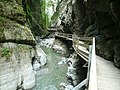 Alploch Gorge
 -
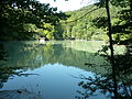 Staufensee
 -
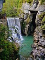 Rappenloch Gorge
 -
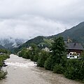 Dornbirn
 -
 Bridge near the river's mouth


See also
[edit]References
[edit]- ^Ölz, Bernhard (1987).Revitalisierung der Dornbirner Ache und damit zusammenhängende stadtplanerisch begleitende Maßnahmen.Wien:Univ. für Bodenkultur(diploma thesis).
External links
[edit]- [1]Current water level of the Dornbirner Ach at Enz
- Dornbirner AchinAustria-Forum(in German)(at AEIOU)


![[1]](/translate/www.vorarlberg.at?u=http%3A%2F%2Fwww.vorarlberg.at%2Fabfluss%2FEnz_dia1_Q.gif&t=hv)
| International | |
|---|---|
| National | |
ThisVorarlberglocation article is astub.You can help Wikipedia byexpanding it. |