
Draft:Wadi Barut
| Review waiting, please be patient.
This may take 3 months or more, since drafts are reviewed in no specific order. There are 2,735 pending submissionswaiting for review.
Where to get help
How to improve a draft
You can also browseWikipedia:Featured articlesandWikipedia:Good articlesto find examples of Wikipedia's best writing on topics similar to your proposed article. Improving your odds of a speedy review To improve your odds of a faster review, tag your draft with relevantWikiProjecttags using the button below. This will let reviewers know a new draft has been submitted in their area of interest. For instance, if you wrote about a female astronomer, you would want to add theBiography,Astronomy,andWomen scientiststags. Editor resources
Reviewer tools
|
This article has multiple issues.Please helpimprove itor discuss these issues on thetalk page.(Learn how and when to remove these template messages)
|
| Wadi Barut | |
|---|---|
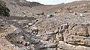
 Wadi Barut, a tributary of the Wadi Ghalilah, in the Emirate of Ras Al Khaimah | |
 | |
| Location | |
| Country | |
| Emirate | |
| Physical characteristics | |
| Source | Northern slope ofJabal ar Rahrah(1,691 m)Al Hajar Mountains |
| • elevation | 1,430 m (4,690 ft) |
| Mouth | Confluence with theWadi Litibahinto theWadi Ghalilah,at the Wadi Ghalilah Dam[1] |
• coordinates | 25°58′35″N56°09′02″E/ 25.97639°N 56.15056°E |
• elevation | 140 m (460 ft) |
| Length | 4.5 km (2.8 mi) |
| Basin size | 76.32 km2(29.47 sq mi) |
| Basin features | |
| River system | Wadi Ghalilah |
TheWadi Barut(Arabic:وادي باروت,romanized:Wādī Barut),[2][3][4]is a valley ordry river,withephemeralor intermittent flow, flowing almost exclusively during the rainy season, located in the northeast of theUnited Arab Emirates,in theEmirate of Ras Al Khaimah.
The Wadi Barut and theWadi Litibahjoin to form theWadi Ghalilahat theirconfluence.The Wadi Barut is formed mainly by the ravines and gullies that run along the northern slope of theJabal ar Rahrah(1,691 m (5,548 ft)); along the western slope of Jabal Bil Ays / Jebel Jais (1,911 m (6,270 ft));[5]and along the eastern slope of a branch of the Jabal Ar Rahrah Ridge.[6]
Course
[edit]In its course, from south to north, the Wadi Barut crosses cultivation areas interracesand farms built on its eastern bank, grouped in the small villages ofDafalas (Dirat Dafalas),[2],Deira Al-Rakba,[7],Barut, Qa`az,[8] Abba,[8]Salajat and others, communicated through a donkey trail that runs between the dam of theWadi Ghalilah(Wadi Ghalilah Dam)[1]and the Jabal Ar Rahrah Ridge.[9]
Very close to the village of Deira Al-Rakba, the three main branches of Wadi Barut join together and form several spectacular dry waterfalls, known as Wadi Barut Dry Falls.[10]

In the area of confluencewith theWadi Litibah,to form theWadi Ghalilah,there are also small farms on both banks of the wadi, which can be accessed via a road of stone and gravel. Those on the right bank are located at the foot of a large rock wall, 600 m high, called Barut Wall, valued by climbers as the longest climbing route in the country.[11][12]
Toponymy
[edit]Alternative Names: Wadi Barut, Wādī Barut, Wadi Barun.[13]
The name ofWadi Barutwas recorded in the documentation and maps produced between 1950 and 1960 by the British Arabist, cartographer, military officer, and diplomatJulian F. Walkerduring the work carried out to establish borders between what was then calledTrucial States,[8]later completed by theMinistry of Defence (United Kingdom),on 1:100,000 scale maps published in 1971.[3]
It also appears, with the spellingWādī Barut,in the National Atlas of the United Arab Emirates.[2]
In the political and administrative organization of the Emirate of Ras Al Khaimah, the name of the main wadi is frequently used as an identifying element of the entire territory covered by itsdrainage basin.
In the case ofWadi Ghalilah,this drainage basin is very large 76.32 km2(29.47 sq mi),[14]comprising numerous towns, villages and farms widely scattered throughout its valleys and mountains. Naturally, it also includes all the ravines and tributaries of the main wadi.
The same denomination is also used for postal purposes.
For this reason, the mistake of considering that this is the only name that corresponds to all the different wadis, and even to some population centers in this region, is widespread, frequently ignoring the true name of each of these places.
This has contributed to the fact that Wadi Barut has also been incorrectly referred to as Wadi Ghalilah on a few occasions.
Population
[edit]The geographical area of Wadi Barut was historically inhabited by the semi-nomadic tribeShihuh,section ofBani Shatair(Arabic:بني شطير), which occupied, among other territories, the tribal areas of Bani Bakhit and Banī Sā`ad.[15]
Gallery
[edit]-
 Confluence areaWadi Litibahand Wadi Barut (UAE), next to the Wadi Ghalilah Dam
 -
 Cultivated terraces in the upper area of Wadi Barut -Dirat Dafalas
 -
 Wadi Barut - Tributary of Wadi Ghalilah - In the upper area of Wadi Barut -Dirat Dafalas


See also
[edit]- List of wadis of the United Arab Emirates
- List of mountains in the United Arab Emirates
- List of wadis of Oman
- List of mountains in Oman
References
[edit]- ^abhttps://www.fao.org/aquastat/en/databases/damsFood and Agriculture Organization of the United Nations. AQUASTAT - FAO's Global Information System on Water and Agriculture
- ^abcJāmiʻat al-Imārāt al-ʻArabīyah al-Muttaḥidah. Geoprojects (U.K.) Ltd., The National atlas of the United Arab Emirates, Al Ain: United Arab Emirates University - 1993
- ^abMap FCO 18/1863 - 1971 - Map of Trucial States, Muscat and Oman - Rams - Scale 1:100 000 - Published by D Survey, Ministry of Defence, United Kingdom (1971) - Edition 3-GSGS - The National Archives, London, England <https://www.agda.ae/en/catalogue/tna/fco/18/1863>
- ^Mindat.org Wādī Barut
- ^Peakbagger - Jabal Bil Ays
- ^"The Barun Wall - 2011".www.summitpost.org.Retrieved2023-05-18.
- ^"The start of the wheat harvest season in Ras Al Khaimah - بدء موسم حصاد القمح برأس الخيمة |".www.aletihad.ae(in Arabic).Retrieved2024-06-12.
- ^abcFCO 18/1895 - 1958 - Map - United Arab Emirates (UAE): Ras al-Khaimah - Published by D Survey, Ministry of Defence, United Kingdom - The National Archives, London, England <https://www.agda.ae/en/catalogue/tna/fco/18/1895/n/1>
- ^"UNITED ARAB EMIRATES (UAE) - Ras al-Khaimah (RAK) - Wadi Barut Hiking Trail. From Wadi Ghalilah Dam to Defels and North Col of Jabal Rahabah (Viewing Deck Park)".Wikiloc - Trails of the World.Retrieved2024-06-10.
- ^"UNITED ARAB EMIRATES (UAE) - Ras al-Khaimah (RAK) - From Wadi Ghalilah Dam to Deira Al-Rakba and Wadi Barut Dry Falls Area".Wikiloc - Trails of the World.Retrieved2024-06-10.
- ^"UAE Climbing - 2005"(PDF).A Stark.Foordkelcey.net.Retrieved2023-05-18.
- ^"CLIMBS IN WADI NAQAB AND WADI GHALILAH - 2018".publications.americanalpineclub.org - Author: Peter Thompson.Retrieved2024-06-12.
- ^"Diet of Leopard and Caracal in the Northern United Arab Emirates and Adjoining Oman Territory - 2007"(PDF).www.stuartonnature.com.Retrieved2023-05-18.
- ^United Arab Emirates - Water conservation strategy - Eng Salim Akram. Director of Dams Department. Dr Abdelazim Ebraheem. Water Resources Evaluation Consultant - Natural Disaster Science and Mitigation Engineering: Ministry of Environent and Water UAE - 2021
- ^FO 371/132894 - 1958 Tribes of Trucial States coast - E F Henderson, Julian F Walker, M S Buckmaster - The National Archives, London, England <https://www.agda.ae/en/catalogue/tna/fo/371/132894/n/38>
External links
[edit]![]() Media related toWadi Barutat Wikimedia Commons
Media related toWadi Barutat Wikimedia Commons
Category:Rivers of the United Arab Emirates Category:Geography of the Emirate of Ras Al Khaimah