Dung Gate
| Dung Gate / Silwan Gate / Maghrabi Gate | |
|---|---|
 Dung Gate | |
| General information | |
| Type | city gate |
| Town or city | Jerusalem |
| Coordinates | 31°46′29″N35°14′2″E/ 31.77472°N 35.23389°E |
| Construction started | 1537 |
| Completed | 1541 |
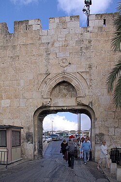
TheDung Gate(Hebrew:שער האשפותSha'ar Ha'ashpot), also known inArabicas theSilwan Gate[1]andMughrabi Gate(Arabic:باب المغاربة,romanized:Bab al-Maghariba,lit. 'Gateof theMaghrebis'),[2][1]is one of theGates of the Old City of Jerusalem.[3]It was built as a smallposterngate in the 16th century by theOttomans,first widened for vehicular traffic in 1952 by theJordanians,and again in 1985 by theIsraeliauthorities.[4]The Dung Gate is a main passage for vehicles coming out of the Old City and for buses headed to theWestern Wall.
Names
[edit]The Dung Gate was originally known as the Maghrebi Gate. This name alludes to theMughrabi Quarter,a neighborhood of North African Kutama Fatimids, which was historically situated just inside the gate. The same name also refers toa different gatewhich overlooks the old Mughrabi Quarter site and allows entrance into theTemple Mountabove.
The Maghrebi Muslims were renowned for their valour in fighting alongsideSalah al-Din,who resettled them on the western side ofAl-Aqsa Mosquein order tore-Islamize the city.His son,al-Afdal Ali,later founded the Mughrabi quarter (Harat al-Maghariba) along with the Preferred School. The entire neighborhood was razed by Israel in the aftermath of theSix-Day Warin order to make way for theWestern Wall Plaza.[5]
In the 19th century,Zionistsbegan to refer to the gate as Dung Gate (Hebrew:שער האשפותSha'ar Ha'ashpot). This was done in commemoration of an ancient gate in the Jerusalem wall from theHebrew Bible(Nehemiah 3:13–14)which was located near thePool of Siloamin the days of the Second Temple. It was probably named after the residue that was taken from theJewish Templeinto theValley of Hinnom,where it was burned. The name was transferred to this small gate - at first, a small rectangular postern in the tower of the wall - in the 19th century.[1][3]
The name Silwan Gate refers to the village ofSilwan,that lies outside the gate, broadly southeast of it.[1]
History
[edit]
The original gate was built after the establishment of the Maghrebi Quarter in the aftermath of theliberation of Jerusalem by Saladin in 1187.The Maghrebi Gate was rebuilt in 1313, during the Mamluk period, byAl-Nasir Muhammad bin Qalawun,during the same time that theChain Gatewas renovated.[6]
Fortified Ottoman postern
[edit]The current gate was built as part of the newcity wallserected underSuleiman the Magnificentbetween 1537 and 1541. The original opening was just 1.5 metres wide, topped by an arch and only designed for pedestrians and pack animals to pass through.[4]Initially the gate, or more precisely thepostern,included an inner gate tower, which was demolished before the end of the Ottoman period.[7]Towards the end of Ottoman rule, a new gate tower or gatehouse was added, but this time outside the wall, in a style that blended in with the 16th-century fortifications.[7]This outer tower was demolished by theBritish Mandate officialsin 1938, probably as part of their drive to restore the walls to their original look, this bringing back to light the old stone decorations.[7][8]
Jordanian and Israeli modernisation
[edit]In 1952, when the gate was widened by the Jordanian authorities to allow cars and buses to pass through it, a reinforced concrete girder was installed under the old stone arch.[4][8]In 1984-85 the gate was again enlarged, the old arch and the other decorative elements being raised, so that the opening reached a height of 4.5 metres.[4][8]The modern gate is built of reinforced concrete, but clad in stone, and the new design helps the old and new elements blend together without disturbing the general style of the city wall,[4]with the gate's opening closing in a more curvy line instead of the straight Jordanianlintel.[7]Landscape architectShlomo Aronsoncooperated with architect Arthur Kutcher at implementing the decision of theJerusalem Foundationestablished by then-mayorTeddy Kollek,motivated by the sharp increase in pilgrims traffic.[4]
See also
[edit]References
[edit]- ^abcd"Dung Gate".Jerusalem Municipality.Retrieved2023-03-11.
- ^Michael Avi-Yonah(1973).Jérusalem.Keter. p. 78.ISBN9780706513257.
Dung Gate (Bab al-Maghariba, or Moor Gate, because of its proximity to the quarter of the Maghreb Muslims)
- ^abJerusalem Municipality,Dung Gate
- ^abcdef"Dung Gate Jerusalem".Shlomo Aronson Architects.Retrieved18 June2020.
- ^Al-Jallad, I. (2017).معالم المسجد الأقصى تحت المجهر [Al-Aqsa Mosque landmarks under the microscope].Baytul Maqdis Center for Literature.
- ^Ghosheh, M. Hashim. (2005).Guide to the Masjid al-Aqsa; an Architectural and Historical Guide to the Islamic Monuments in the Masjid al-Aqsa.Ministry of Awqaf and Religious Affairs.
- ^abcd"The Conservation of Jerusalem's City Walls: The Dung Gate Section".Israel Antiquities Authority.Retrieved18 June2020.
- ^abcDung Gate.The Jerusalem Foundation. Archived fromthe originalon 20 June 2020.Retrieved18 June2020.
External links
[edit]- Bab al-MagharibaArchived2019-10-15 at theWayback Machine
- Pictures of the Dung Gate
- Moors site


