
Edayilakkad
 Edayilakkad | |
 | |
| Geography | |
|---|---|
| Location | Lake Kavvayi |
| Adjacent to | TheKanara |
| Administration | |
Kasaragod district,India | |
| Demographics | |
| Population | 1305 |
Edayilakkad(also spelledEdayilakkaduorEdayilekkadu,is a marshy island situated inValiyaparamba Panchayath,Kasaragod district,Kerala,India.It is located in theKavvayi Backwaters,a long, almost isolated, arm of the Arabian Sea. Edayilakkad is noted for its biodiversity and local conservation efforts.[1]The island is three to four meters above sea level on average. To the east of Edayilakkad lies the mainland of India.
History
[edit]Historic knowledge of the remote area dates to the 2nd century AD. Although it wasn't inhabited until the early 1900s,feudalLingayatsof theVijayanagara Empireonce controlled the region.[2]Before the formation of the Kerala state, the area was part ofMadras.An emigration of a mainlySri Lankanlabour force onto the island occurred in the 1930s.[citation needed]
Location
[edit]To the south of Edayilakkad lies the island of Madakkal, while the village ofTrikkarippuris located on the mainland east of Edayilakkad. The village ofAyittiis due north of the island. The island lies on theMalabar coast.According to India's revenue department, the island has an area of 312.01 acres (126.27 ha). Due to its width, Edayilakkad is one of the largest islands in the northern parts of Kerala.
Geography
[edit]Lake Kavvayi, in which Edayilakkad is situated, is separated from theArabian Seaon the west by a thin strip of land, which was probably formed due toembayment(a gradual separation of the lake from the sea). This strip is calledValiyavaramba(meaning "Big Border" ). The area of Lake Kavvayi is approximately 1,264 km2(488 sq mi).[3]

Backwaters
[edit]Located 30 km [19 mi] fromBekal,the Kavvayi Backwaters is one of the most picturesque backwater boroughs in Kerala.[citation needed]The Valiyaparamba Backwaters of Edayilakkad are approximately 21 km [13 mi] long, and 37.0 km [23.0 mi] long; and are formed from the confluence of seven rivers. The backwaters are at the southern end of the Tejeswini River.
Population
[edit]There are 1,305 people living in 250 houses on the island.[4][failed verification]
Fauna and flora
[edit]Edayilakkad is biodiverse,[5]including being a nesting area for the state endangeredwhite-bellied sea eagle,[6][7][8]and home toNerviliaorchids.[6]The island is a home to a largemangroveforestbiome.[citation needed]
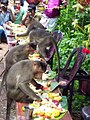
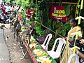
Shelter for Monkeys
[edit]A small forest (it is called "Kaavu" ) is there in Edayilakkad. It is the shelter for many monkeys. There are so many monkeys there. It is an attraction for visitors. They will feed the monkeys. More over, an old lady, living nearby, feeds the monkeys regularly. On special occasions like the festival, Onam, special feast is given to the monkeys.
-
 Feast for Monkeys as a part of ONAM Festival.
 -


References
[edit]- ^Kumar, M K Sunil (22 March 2017)."Kerala Falls Behind in Rainwater Harvesting - Times of India".The Times of India.Indiatimes.Retrieved7 July2017.
- ^Keladi Nayakas - The Rebellious Rani of Belavadi and Other Stories.Atlantic Publishers & Dist. 2001.ISBN9788126901272.Retrieved9 July2017.
{{cite book}}:|work=ignored (help) - ^News;keralakaumudi.com; retrieved July 2017Archived16 March 2017 at theWayback Machine
- ^Responsible Tourism;Kerala Editor; retrieved July 2017
- ^"Proposal Submitted to Government of India: Integrated Coastal Zone Management"(PDF).sisem.in.Government of Kerala. 2015. p. 60.Retrieved9 July2017.
The area has rich biodiversity. The sacred grove viz. Edayilakkad island preserves many rare and endemic species.
[permanent dead link] - ^abP S Harikumar."Wetlands of Kerala: Degradation, Restoration and Future Management - A Case Study of Kavvayi Wetlanda Coastal Wetland in the Northern Kerala"(PDF).wgbis.ces.iisc.ernet.in.Centre for Ecological Sciences, Indian Institute of Science, Bangalore. p. 2.Retrieved9 July2017.
- ^Bernama (15 November 2011)."White-Bellied Sea Eagle Under Threat In Kerala".ssig.gov.my.South-South Information Gateway.Retrieved9 July2017.
- ^Muhamed Jafer.P (2000).""Habitat use of birds of north malabar coast with special reference to the white bellied sea eagle, haliaeetus leucogaster" Thesis: Chapter 4 - Biology and Ecology of Whitebellied Sea Eagle, Halineetus leucogaster (Gmelin) "(PDF).shodhganga.inflibnet.ac.in.Department of Zoology, St. Joseph's College Devagiri, University of Calicut. pp. 64, 57, 68.Retrieved9 July2017.
12°07′59″N75°09′25″E/ 12.133°N 75.157°E
This article related to a location inKasaragod district,Kerala,Indiais astub.You can help Wikipedia byexpanding it. |