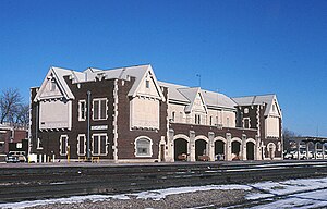
Emporia station
Appearance
Emporia, KS | |||||||||||||||||||||||||
|---|---|---|---|---|---|---|---|---|---|---|---|---|---|---|---|---|---|---|---|---|---|---|---|---|---|
 Emporia station in October 1982 | |||||||||||||||||||||||||
| General information | |||||||||||||||||||||||||
| Location | 3rd Avenue and Neosho Street Emporia, Kansas | ||||||||||||||||||||||||
| Coordinates | 38°24′05″N96°11′13″W/ 38.401494°N 96.186866°W | ||||||||||||||||||||||||
| Line(s) | BNSFEmporia Subdivision | ||||||||||||||||||||||||
| History | |||||||||||||||||||||||||
| Opened | 1882 | ||||||||||||||||||||||||
| Closed | May 11, 1997 | ||||||||||||||||||||||||
| Rebuilt | 1926, 1957 | ||||||||||||||||||||||||
| Former services | |||||||||||||||||||||||||
| |||||||||||||||||||||||||
| |||||||||||||||||||||||||
Emporia stationwas a railway station inEmporia, Kansas,United States. It was built in 1882 by theAtchison, Topeka and Santa Fe Railwayand was renovated in 1926 and 1957.[1]Amtraktook over intercity passenger service in 1971 and continued serving Emporia with theTexas ChiefandSuper Chief.TheTexas Chiefwas renamedLone Starin 1974 and discontinued in 1979. TheSuper Chiefwas renamedSouthwest Limitedin 1974 andSouthwest Chiefin 1984. Emporia was dropped as a stop in 1997.[2]The station building was destroyed by a fire on August 9, 1999.[3]
References
[edit]- ^"Railroads in Lyon County".The Emporia Gazette.March 6, 2010.RetrievedJune 13,2023.
- ^Sanders, Craig (2006).Amtrak in the Heartland.Bloomington, Indiana:Indiana University Press.p. 134.ISBN978-0-253-34705-3.
- ^"End of the Line: Fire guts historic depot".The Salina Journal.August 10, 1999. p. 3 – via Newspapers.com.
External links
[edit]![]() Media related toEmporia stationat Wikimedia Commons
Media related toEmporia stationat Wikimedia Commons
Categories:
- Former Amtrak stations in Kansas
- Former Atchison, Topeka and Santa Fe Railway stations
- 1884 establishments in Kansas
- Railway stations in the United States opened in 1884
- Railway stations in the United States closed in 1997
- Midwestern United States railway station stubs
- Kansas building and structure stubs
- Kansas transportation stubs

