
Endingen, Switzerland
Endingen | |
|---|---|
 | |
 Flag  Coat of arms | |
Location of Endingen  | |
 Endingen  Endingen | |
| Coordinates:47°32′N8°17′E/ 47.533°N 8.283°E | |
| Country | Switzerland |
| Canton | Aargau |
| District | Zurzach |
| Area | |
| • Total | 11.92 km2(4.60 sq mi) |
| Elevation | 383 m (1,257 ft) |
| Population (31 December 2018)[2] | |
| • Total | 2,530 |
| • Density | 210/km2(550/sq mi) |
| Time zone | UTC+01:00(Central European Time) |
| • Summer (DST) | UTC+02:00(Central European Summer Time) |
| Postal code(s) | 5304 |
| SFOS number | 4305 |
| ISO 3166 code | CH-AG |
| Surrounded by | Baldingen,Lengnau,Obersiggenthal,Unterendingen,Würenlingen |
| Website | www SFSO statistics |
Endingen(Swiss German:[ˈɛndɪgə]) is amunicipalityin the district ofZurzachin thecantonofAargauinSwitzerland.
In the 18th and 19th century, Endingen was one of few villages in whichSwiss Jewswere permitted to settle. Old buildings in Endingen have two doors – one for Jews and one for Christians. Endigen'ssynagogueand Jewish cemetery are listed as aheritage site of national significance.Unusually for Swiss villages, there is no Christian church.
On 1 January 2014 the former municipality ofUnterendingenmerged into the municipality of Endingen.[3]
History
[edit]
Individual items from theNeolithicandBronze Agehave been discovered around Endingen. In theEarly Middle AgestheAlamannisettled in the area. The modern village of Endingen is first mentioned in 798 asEntingas.Until 1945 it was known asOberendingen.[4]During theHigh Middle Agesthe major landholders in village includedRegensberg,theBishop of Constance,theFreiherrofTegerfeldenand the lords of Endingen. Starting in the 13th century the village was under theHabsburgs.After the conquest of the Aargau in 1415 by theSwiss Confederationit was part of thehigh courtof the bailiff of Baden. The low court rights lay withSankt Blasien Abbey in the Black Forest.The landherrschaftrights were held by a number of different owners.
In accordance with the resolution of theTagsatzungin 1678,Jewswere allowed to settle in the communities of theSurbvalley. After 1776, they were further restricted to living in only Endingen andLengnau.[5]This immigration slowly but steadily changed the appearance of the community. The village never built a Christian church, only a Jewish synagogue. The local Christians traveled to neighboring villages for church. The Jewish and Christian families are often under one roof. In the middle of the 19th century the village had about 2,000 inhabitants, about half Jews and half Christians. By comparison, the town ofBadenhad about 1,500 people at the same time.[6]The Jewish population was fairly well tolerated (except for theZwetschgenkriegor "plum war" riots in 1802), self-managed and maintained its own school. In 1879 a Jewish village of Neu-Endingen was built. It remained mostly independent until 1983 when it merged back into the village of Endingen.[4]

However, even though they were nearly a majority in Endingen, the Jewish residents were only allowed to enter a few professions, such as trade. Houses were built with two separate entrances, one for Jews and one for Christians.[6]They were under the high and low courts of the Baden bailiff and had to buy "protection and safety" letters from the authorities.[4]It wasn't until 1876 that Jews were granted full equality in civil rights and allowed to travel. By 1920, most Jews had left the community.
Since 1661, theCatholicsin Endingen have been part of theparishof Unterendingen (previouslyZurzach), while theReformedmembers are part of theTegerfeldenparish. The only house of worship is the synagogue of Endingen. It was built in 1764 and rebuilt in 1852.[4]
Plum war
[edit]In 1798, theFrench invaded Switzerlandand set up theHelvetic Republic.The Republic attempted to modernize and centralize the Swiss Confederation. As part of this new, liberal state, Swiss reformers attempted to enforce the emancipation of the Jews in the new central Swiss Parliament inAarau.When that failed, they attempted to get the French to force this change on the new Swiss government. The changes of the Republic were not embraced by many of the Swiss and the issue of emancipation for the Jews became another contentious issue between the old order and the new government. Finally in 1802 the population revolted and turned against the Jews. The mob looted the Jewish villages of Endingen and Lengnau. At the same time other revolts, such as theStecklikrieg,stretched the French Army too far.Napoleon Bonapartelacked the troops to bring peace to Switzerland, and also he needed the Swiss regiments for his campaigns. Seeking a peaceful resolution to the uprising, in 1803 he issued theAct of Mediation.The Act of Mediation was a compromise between theAncien Regimeand a Republic. One of the compromises in the Act was that no further rights were granted to the Jews.[7]
Geography
[edit]
Endingen has an area, as of 2009[update],of 8.46 square kilometers (3.27 sq mi). Of this area, 3.8 km2(1.5 sq mi) or 44.9% is used for agricultural purposes, while 3.84 km2(1.48 sq mi) or 45.4% is forested. Of the rest of the land, 0.77 km2(0.30 sq mi) or 9.1% is settled (buildings or roads), 0.03 km2(7.4 acres) or 0.4% is either rivers or lakes.[8]
Of the built up area, housing and buildings made up 5.8% and transportation infrastructure made up 2.4%. Out of the forested land, 43.7% of the total land area is heavily forested and 1.7% is covered with orchards or small clusters of trees. Of the agricultural land, 27.4% is used for growing crops and 14.2% is pastures, while 3.3% is used for orchards or vine crops. All the water in the municipality is flowing water.[8]
The municipality is located in the Zurzach district, in theSurb river valley.It consists of thehaufendorfvillage (an irregular, unplanned and quite closely packed village, built around a central square) of Endingen and thehamletof Loohof.
Coat of arms
[edit]Theblazonof the municipalcoat of armsisPer pale Argent a Fleur-de-lis mediated Gules and Or.[9]
Demographics
[edit]Endingen has a population (as of December 2020[update]) of 2,597.[10]As of June 2009[update],14.9% of the population are foreign nationals.[11]Over the last 10 years (1997–2007) the population has changed at a rate of 10.2%. Most of the population (as of 2000[update]) speaksGerman(92.9%), withAlbanianbeing second most common ( 2.4%) andFrenchbeing third ( 1.2%).[12]
The age distribution, as of 2008[update],in Endingen is; 244 children or 12.5% of the population are between 0 and 9 years old and 231 teenagers or 11.8% are between 10 and 19. Of the adult population, 217 people or 11.1% of the population are between 20 and 29 years old. 267 people or 13.6% are between 30 and 39, 330 people or 16.9% are between 40 and 49, and 247 people or 12.6% are between 50 and 59. The senior population distribution is 220 people or 11.2% of the population are between 60 and 69 years old, 133 people or 6.8% are between 70 and 79, there are 61 people or 3.1% who are between 80 and 89, and there are 7 people or 0.4% who are 90 and older.[13]
As of 2000[update]the average number of residents per living room was 0.56 which is about equal to the cantonal average of 0.57 per room. In this case, a room is defined as space of a housing unit of at least 4 m2(43 sq ft) as normal bedrooms, dining rooms, living rooms, kitchens and habitable cellars and attics.[14]About 58.7% of the total households were owner occupied, or in other words did not pay rent (though they may have amortgageor arent-to-ownagreement).[15]
As of 2000[update],there were 46 homes with 1 or 2 persons in the household, 315 homes with 3 or 4 persons in the household, and 322 homes with 5 or more persons in the household.[16]As of 2000[update],there were 699 private households (homes and apartments) in the municipality, and an average of 2.5 persons per household.[12]In 2008[update]there were 377 single family homes (or 46.0% of the total) out of a total of 819 homes and apartments.[17]There were a total of 0 empty apartments for a 0.0% vacancy rate.[17]As of 2007[update],the construction rate of new housing units was 7.3 new units per 1000 residents.[12]
In the2007 federal electionthe most popular party was theSVPwhich received 32.53% of the vote. The next three most popular parties were theCVP(25.45%), theSP(16.3%) and theFDP(11.3%). In the federal election, a total of 792 votes were cast, and thevoter turnoutwas 59.0%.[18]
Historic population
[edit]The historical population is given in the following chart:[19]

Heritage sites of national significance
[edit]TheJewish cemeteryon Hauptstrasse and theSynagogueon Hintersieg are listed as Swiss heritage sites of national significance. The entire village of Unterendingen is designated as part of theInventory of Swiss Heritage Sites.[20]The entire village of Endingen is designated as part of theInventory of Swiss Heritage Sites.[21]
-

-
 Synagogue of Endingen
 -
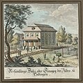 18th century copperplate etching of the Endingen synagogue. In theJewish Museum of Switzerland'scollection.


Economy
[edit]As of 2007[update],Endingen had an unemployment rate of 1.44%. As of 2005[update],there were 92 people employed in theprimary economic sectorand about 34 businesses involved in this sector. 184 people are employed in thesecondary sectorand there are 21 businesses in this sector. 263 people are employed in thetertiary sector,with 50 businesses in this sector.[12]
In 2000[update]there were 942 workers who lived in the municipality. Of these, 694 or about 73.7% of the residents worked outside Endingen while 239 people commuted into the municipality for work. There were a total of 487 jobs (of at least 6 hours per week) in the municipality.[22]Of the working population, 12.3% used public transportation to get to work, and 52.6% used a private car.[12]
Religion
[edit]From the 2000 census[update],911 or 51.6% wereRoman Catholic,while 563 or 31.9% belonged to the Swiss Reformed Church. Of the rest of the population, there were 4 individuals (or about 0.23% of the population) who belonged to theChristian Catholicfaith.[16]
Education
[edit]The entire Swiss population is generally well educated. In Endingen about 82.3% of the population (between age 25 and 64) have completed either non-mandatoryupper secondary educationor additional higher education (either university or aFachhochschule).[12]Of the school age population (in the 2008/2009 school year[update]), there are 148 students attendingprimary school,there are 297 students attendingtertiary or university level schoolingin the municipality.[16]
References
[edit]- ^ab"Arealstatistik Standard - Gemeinden nach 4 Hauptbereichen".Federal Statistical Office.Retrieved13 January2019.
- ^"Ständige Wohnbevölkerung nach Staatsangehörigkeitskategorie Geschlecht und Gemeinde; Provisorische Jahresergebnisse; 2018".Federal Statistical Office. 9 April 2019.Retrieved11 April2019.
- ^Nomenklaturen – Amtliches Gemeindeverzeichnis der SchweizArchived2015-11-13 at theWayback Machine(in German)accessed 13 December 2014
- ^abcdEndingeninGerman,FrenchandItalianin the onlineHistorical Dictionary of Switzerland.
- ^Battegay, Lubrich, Caspar, Naomi (2018).Jewish Switzerland: 50 Objects Tell Their Stories.Basel: Christoph Merian. pp. 62–65.ISBN9783856168476.
{{cite book}}:CS1 maint: multiple names: authors list (link) - ^abEndingen municipal website - History(in German)accessed 16 June 2010
- ^Swiss Jews website(in German)accessed 16 June 2010
- ^abSwiss Federal Statistical Office-Land Use Statistics2009 data(in German)accessed 25 March 2010
- ^Flags of the World.comArchived2012-10-05 at theWayback Machineaccessed 16-June-2010
- ^"Ständige und nichtständige Wohnbevölkerung nach institutionellen Gliederungen, Geburtsort und Staatsangehörigkeit".bfs.admin.ch(in German). Swiss Federal Statistical Office - STAT-TAB. 31 December 2020.Retrieved21 September2021.
- ^Statistical Department of Canton Aargau -Bereich 01 -BevölkerungArchived2012-02-22 at theWayback Machine(in German)accessed 20 January 2010
- ^abcdefSwiss Federal Statistical OfficeArchivedJanuary 5, 2016, at theWayback Machineaccessed 16-June-2010
- ^Statistical Department of Canton Aargau -Bevölkerungsdaten für den Kanton Aargau und die Gemeinden (Archiv)Archived2012-02-22 at theWayback Machine(in German)accessed 20 January 2010
- ^Eurostat. "Housing (SA1)".Urban Audit Glossary(PDF).2007. p. 18. Archived fromthe original(PDF)on 14 November 2009.Retrieved12 February2010.
- ^Urban Audit Glossary pg 17
- ^abcStatistical Department of Canton Aargau - Aargauer Zahlen 2009Archived2012-02-22 at theWayback Machine(in German)accessed 20 January 2010
- ^abStatistical Department of Canton AargauArchived2012-02-22 at theWayback Machine(in German)accessed 20 January 2010
- ^Swiss Federal Statistical Office,Nationalratswahlen 2007: Stärke der Parteien und Wahlbeteiligung, nach Gemeinden/Bezirk/CantonArchivedMay 14, 2015, at theWayback Machine(in German)accessed 28 May 2010
- ^Federal Statistical Office STAT-TAB Bevölkerungsentwicklung nach Region, 1850-2000ArchivedMarch 17, 2012, at theWayback Machine(in German)accessed 29 January 2011
- ^"Kantonsliste A-Objekte: Aargau".KGS Inventar(in German). Federal Office of Civil Protection. 2009. Archived fromthe originalon 28 June 2010.Retrieved28 May2010.
- ^ISOS siteaccessed 16-June-2010
- ^Statistical Department of Canton Aargau-Bereich 11 Verkehr und NachrichtenwesenArchived2012-02-22 at theWayback Machine(in German)accessed 21 January 2010
External links
[edit]- EndingeninGerman,FrenchandItalianin the onlineHistorical Dictionary of Switzerland.
MunicipalitiesinZurzach District,Switzerland | ||
|---|---|---|
| International | |
|---|---|
| National | |
| Geographic | |
| Other | |