
Erebus (crater)
 | |
| Planet | Mars |
|---|---|
| Region | Meridiani Planum |
| Coordinates | 2°06′S5°30′W/ 2.1°S 5.5°W |
| Quadrangle | Margaritifer Sinus |
| Diameter | ~350 metres |
| Depth | Effectively zero depth |
| Discoverer | Opportunityrover |
| Eponym | HMSErebus |

Erebusis acraterlying situated within theMargaritifer Sinus quadrangle(MC-19) region of the planetMars,this extraterrestrial geological feature was visited by theOpportunityroveron the way to the much larger craterVictoria.It is named after the polar exploration vesselHMSErebuswhich was used byJames Clark Rossin 1841 to discover theGreat Ice Barrier,now known as theRoss Ice Shelf.The rover was in the immediate vicinity of the crater from approximatelysol550 to 750 (October 2005 to March 2006).
This crater features two other minor named outcrops on the edges of this topographical depression. These includePayson RidgeandOlympia Ridge(see gallery below).
Erebus is located roughly 2,500 metres (8,200 ft) south of the much smaller craterVostok,which was previously visited byOpportunity.It is located within a type of terrain that a team of scientists led by J. M. Metz described as "etched terrain". The etched terrain is characterized by heavily eroded rocks that form polygonal structures separated by ridges and valleys.[1]
Erebus is about 350 metres (1,150 ft) wide, twice as large as the craterEndurance.However, it is very old and eroded, and is barely visible from the ground; it appears merely as a number of flat rocky outcrops encircling a region ofdunes.
-
 An outcrop named "Payson", on the western edge of Erebus.
 -
 "Olympia" outcrop on northwestern margin of Erebus
 -
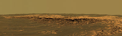
 Color panorama taken byOpportunityon the rim of Erebus. The crater itself can be seen in the center of the pan, at the top.


See also[edit]
References[edit]
- ^Metz, J. M.; Grotzinger, J. P.; Rubin, D. M.; Lewis, K. W.; Squyres, S. W.; Bell, J. F. (1 May 2009). "Sulfate-Rich Eolian and Wet Interdune Deposits, Erebus Crater, Meridiani Planum, Mars".Journal of Sedimentary Research.79(5): 247–264.doi:10.2110/jsr.2009.033.
External links and further reading[edit]
- NASA Astronomy Picture of the Day: from Nov 8 2005 on Erebus and Opportunity Rover (8 November 2005)
- Grotzinger; Bell, J.; Herkenhoff, K.; Johnson, J.; Knoll, A.; McCartney, E.; McLennan, S.; Metz, J.; et al. (2006). "Sedimentary textures formed by aqueous processes, Erebus crater, Meridiani Planum, Mars".Geology.34(12): 1085–1088.Bibcode:2006Geo....34.1085G.doi:10.1130/G22985A.1.
- Structure and Sedimentology of the Western Margin of Erebus Crater, Meridiani Planum, Mars
- Erebrus and Victoria by Mars Express HRSC + SRCArchived2017-01-27 at theWayback Machine
Features onMarsvisited byOpportunity | ||
|---|---|---|
| Craters | ||
| Endeavour | ||
| Rocks(list) | ||