Fatutaka


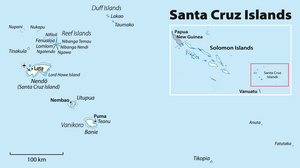
Fatutaka,Fatu TakaorPatu Taka(also known as Fataka and Mitre Island)[1][2]is a smallvolcanic islandinTemotu Province,in the nation ofSolomon Islands,south-westPacific Ocean. The easternmost island in Solomon Islands, Fatutaka is locatedc.32 km (20 mi) southeast ofAnutaand can be seen from there in clear weather.[3][2] Fatutaka and Anuta were discovered for Europeans by AdmiralEdward Edwardsin 1791.[4]
The island, located at11°54′36″S170°11′24″E/ 11.91000°S 170.19000°E,is a small rocky outcropping, rising to an elevation of 122 m (400 ft). The total land area of the island is 18 ha (44 acres).[citation needed]
Human activities[edit]
The island's soil is rocky, and not especially fertile, although it has in the past been used as agardeninglocation for the people of Anuta.[citation needed]
The population of Anuta, the closest inhabited island, regularly sail to Fatutaka to eat and collect sea-birds and their eggs.[3] The birds of Fatukaka have never been surveyed although the presence ofFrigatebird,Eastern Reef Egret,Pacific Imperial Pigeon,andEmerald Dovehave been reported.[2][5]
Geology[edit]
Fatutaka is one of numerous volcanic highs, islands and banks, in the north-western North Fiji Basin south of the fossilVitiaz Trench(10°30'–19°S, 169°–174°E). These highs are, however, located up to 240 km (150 mi) from the Vitiaz Trench and do not form a continuous chain derived from the trench, but are a series of massifs aligned on north–south trending faults. Anuta and Fatutaka consist ofbasalticlavas andandesiticbreccias.[6]
In the 1970s the formation of Anuta and Fatutaka 2.2Mawas attributed to volcanism in the Vitiaz island arc during the initialback-arcopening of theNorth Fiji Basin.The Vitiaz Arc volcanoes were, however, displaced in an earlier episode and the formation of the islands is now attributed to renewed volcanism associated with a change in motion of thePacific Plate2 Ma.[7]
See also[edit]
References[edit]
Notes[edit]
- ^Feinberg 1988,p. 181
- ^abcSteadman, Pahlavan & Kirch 1990,pp. 119–120
- ^abKirch 2002,p. 76
- ^Quanchi & Robson 2005,Pacific Islands and Their First European Visitors, pp. xiii–xxv
- ^Tarburton 2015
- ^Pelletier, Lafoy & Missegue 1993,p. 1153
- ^Kroenke 1995,Northern New Hebrides Back-Arc Area, pp. 21–22
Sources[edit]
- Feinberg, Richard (1988).Polynesian Seafaring and Navigation: Ocean Travel in Anutan Culture and Society.Kent State University Press.ISBN9780873387880.Retrieved2009-10-16.
- Kirch, P. V. (2002)."Te Kai Paka-Anuta: food in a Polynesian outlier society".Le Journal de la Société des Océanistes.114–115 (114–115): 71–89.doi:10.4000/jso.1404.Retrieved2 April2017.
- Kroenke, L. W. (1995).A Morphotectonic Interpretation of SOPACMAPS 1: 500 000 Charts: Central Solomon Islands-Southern Tuvalu(PDF)(Report). SOPMAC Technical report 220. South Pacific Applied Geoscience Commission.Retrieved2 April2017.
- Pelletier, B.; Lafoy, Y.; Missegue, F. (1993)."Morphostructure and magnetic fabric of the northwestern North Fiji Basin".Geophysical Research Letters.20(12): 1151–1154.Bibcode:1993GeoRL..20.1151P.doi:10.1029/93gl01240.Retrieved2 April2017.
- Steadman, D. W.;Pahlavan, D. S.; Kirch, P. V. (1990)."Extinction, biogeography, and human exploitation of birds on Tikopia and Anuta, Polynesian outliers in the Solomon Islands"(PDF).Bishop Mus. Occas. Pap.30:118–153.Retrieved2 April2017.
- Tarburton, M. K. (12 June 2015)."Fataka (Mitre) Island Bird Checklist"(PDF).Birds of Melanesia.Retrieved2 April2017.
- Quanchi, M.; Robson, J. (2005).Historical dictionary of the discovery and exploration of the Pacific islands.Scarecrow Press.ISBN9780810865280.Retrieved2 April2017.
