Fiddington
| Fiddington | |
|---|---|
 | |
Location withinSomerset | |
| Population | 298 (2011)[1] |
| OS grid reference | ST215405 |
| Unitary authority | |
| Ceremonial county | |
| Region | |
| Country | England |
| Sovereign state | United Kingdom |
| Post town | BRIDGWATER |
| Postcode district | TA5 |
| Dialling code | 01278 |
| Police | Avon and Somerset |
| Fire | Devon and Somerset |
| Ambulance | South Western |
| UK Parliament | |
Fiddingtonis a village andcivil parish2.5 miles (4 km) north-east ofNether Stowey,and 6 miles (10 km) north-west ofBridgwaterinSomerset,England. The parish includes thehamletsofBonsonandWhitnell.
Governance
[edit]Theparish councilhas responsibility for local issues, including setting an annual precept (local rate) to cover the council’s operating costs and producing annual accounts for public scrutiny. The parish council evaluates local planning applications and works with the local police, district council officers, andneighbourhood watchgroups on matters of crime, security, and traffic. The parish council's role also includes initiating projects for the maintenance and repair of parish facilities, as well as consulting with the district council on the maintenance, repair, and improvement of highways, drainage, footpaths, public transport, and street cleaning. Conservation matters (including trees and listed buildings) and environmental issues are also the responsibility of the council.
Forlocal governmentpurposes, since 1 April 2023, the village comes under theunitary authorityofSomerset Council.Prior to this, it was part of thenon-metropolitan districtofSedgemoor,which was formed on 1 April 1974 under theLocal Government Act 1972,having previously been part ofBridgwater Rural District.[2]
It is also part of theBridgwatercounty constituencyrepresented in theHouse of Commonsof theParliament of the United Kingdom.It elects oneMember of Parliament (MP)by thefirst past the postsystem of election, and was part of theSouth West England constituencyof theEuropean Parliamentprior toBritain leaving the European Unionin January 2020, which elected sevenMEPsusing thed'Hondt methodofparty-list proportional representation.
Religious sites
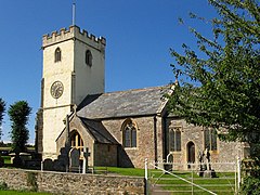
[edit]TheChurch of St Martindates from the 11th century and has been designated byEnglish Heritageas a Grade II*listed building.[3]On the south wall of the nave is a 12 inches (30 cm)Sheela na Gig.[4][5]It is unusual in having one arm aloft and the other resting on a knee. The part of the figure showing genitalia is less well defined than the upper body, possibly as a result of weathering or an attempt to obscure that part of the image at some time in the past.[6]
References
[edit]- ^"Statistics for Wards, LSOAs and Parishes — SUMMARY Profiles"(Excel).Somerset Intelligence.Retrieved4 January2014.
- ^"Bridgwater RD".A vision of Britain Through Time.University of Portsmouth.Retrieved4 January2014.
- ^Historic England."Church of St Martin (1264213)".National Heritage List for England.Retrieved2 February2008.
- ^Adkins, Lesley; Roy Adkins (1992).A field guide to Somerset archaeology.Wimborne, Dorset: Dovecote Press. pp. 62–63.ISBN0-946159-94-7.
- ^"The Fiddington Sheela Na Gig".Sheela Na Gig Project.Archived fromthe originalon 23 March 2009.Retrieved2 February2008.
- ^Warren, Derrick (2005).Curious Somerset.Stroud: Sutton Publishing. p. 58.ISBN978-0-7509-4057-3.
External links
[edit]- Map of Fiddington c 1900Archived28 October 2007 at theWayback Machine
- Fiddingon at British History Online


