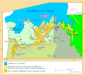
File:Map missoula floods.gif
Appearance
Map_missoula_floods.gif(668 × 481 pixels, file size: 24 KB, MIME type:image/gif)
File history
Click on a date/time to view the file as it appeared at that time.
| Date/Time | Thumbnail | Dimensions | User | Comment | |
|---|---|---|---|---|---|
| current | 00:40, 6 September 2009 |  | 668 × 481(24 KB) | Peteforsyth | moved scale of miles/km; cropped out now-redundant legend. |
| 00:26, 6 September 2009 |  | 668 × 594(26 KB) | Peteforsyth | trimmed it | |
| 02:12, 18 August 2009 |  | 680 × 700(30 KB) | Peteforsyth | {{Information |Description=Map of the Missoula Floods |Source=http://vulcan.wr.usgs.gov/Volcanoes/ColumbiaPlateau/summary_columbia_plateau.html |Date= |Author=USGS |Permission=public domain |other_versions= }} |
File usage
The following 7 pages use this file:
Global file usage
The following other wikis use this file:
- Usage on ca.wikipedia.org
- Usage on de.wikipedia.org
- Usage on es.wikipedia.org
- Usage on fr.wikipedia.org
- Usage on he.wikipedia.org
- Usage on hy.wikipedia.org
- Usage on it.wikipedia.org
- Usage on kw.wikipedia.org
- Usage on pl.wikipedia.org
- Usage on ru.wikipedia.org
- Usage on uk.wikipedia.org


