
Flat Bastion
| Flat Bastion | |
|---|---|
Baluarte de Santiago (formerly) | |
| Part ofFortifications of Gibraltar | |
| Charles V Wall,GibraltarinGibraltar | |
 Section of the 1908Ordnance Surveymap ofGibraltarshowing Flat Bastion. Noteretired flankandorillonon west wall.Flat Bastion Magazineis highlighted in yellow. North is to the left. | |
 Section of 1608 map byCristóbal de RojasincludesSouth Bastionand Flat Bastion, each with anorillonand aretired flank. | |
 Flat Bastion Location of Flat Bastion withinGibraltar. | |
| Coordinates | 36°08′05″N5°21′05″W/ 36.134820°N 5.351388°W |
| Type | Bastion |
| Site information | |
| Owner | Government of Gibraltar |
| Open to the public | Partly |
| Condition | Mostly derelict |
| Site history | |
| Materials | Masonry |
Flat Bastionis abastionwhich projects southward from theCharles V Wallin theBritish Overseas TerritoryofGibraltar.Once known as theSt. Jago's Bastionor theBaluarte de SantiagoinSpanish,thefortificationwas built by the Spanish in the mid 16th century and formed part of the southern defences of the city of Gibraltar, together with Charles V Wall,Southport Gates,Southport Ditch,andSouth Bastion.In 1859, six guns, four 12-pounders[a]and two 12-poundcarronades,were installed on the bastion, and four years later, five 32-pounders[b]were mounted on the fortification.
Flat Bastion takes its name from the angle that its south-facing walls form with each other and with the Charles V Wall. Within the eastern portion of Flat Bastion isFlat Bastion Magazine.The bastion and magazine within it are separately listed with theGibraltar Heritage Trust.The magazine has been restored and converted into a research facility.
Background
[edit]
Flat Bastion is a fortification in the British Overseas Territory of Gibraltar.[1][2]Its north end is along the Charles V Wall, from which it projects southward.Prince Edward's Gate,Prince Edward's Road,andTrafalgar Cemeteryare just to the west of the bastion.[3]Flat Bastion Roadextends to the bastion at the east side of its north face at the Charles V Wall and traverses the bastion at which point it becomesGardiner's Road.[3]
The name of the bastion refers to the faces of the fortification and not to the slope of the ground on which it was built; Flat Bastion was constructed on sloping ground. A 1908 map of the Flat Bastion confirms that its south faces join at anobtuse anglewhich is relatively flat, and nearly parallel to the Charles V Wall.[4][5]Flat Bastion includes Flat Bastion Magazine within its eastern portion, now a geological research and exhibition facility.[6]The bastion is alisted buildingwith the Gibraltar Heritage Trust.[7]While St. Jago's Bastion has been said to be an early name for Flat Bastion, it has a separate listing with the Gibraltar Heritage Trust, next to those for Flat Bastion and Flat Bastion Magazine.[7]
History and features
[edit]The Spanish began construction of Flat Bastion in the 16th century, in 1552, at which time it was referred to as St. Jago's or Santiago's Bastion (Spanish:Baluarte de Santiago).[4][5]According to Dr.Darren Faand ProfessorClive Finlayson,both of theGibraltar Museum,Flat Bastion was built by 1627.[5][8]He speculated thatAlsatianfortress architect and cartographerDaniel Specklin(1536-1589) may have designed it, as its outline was essentially identical to that in the architect's book, including the presence of aretired flank.[5]An earlier 1608 map of Gibraltar byCristóbal de Rojasincludes Flat Bastion and South Bastion, although the British claimed that the Spanish had never finished the construction of Flat Bastion.[9]

In 1859, six guns, four 12-pounders and two 12-poundcarronades,were installed on the bastion, and four years later, five 32-pounders were mounted on the fortification.[4]The earliest defences of the southern end of the city of Gibraltar included the 16th century Charles V Wall, Flat Bastion, South Bastion, Southport Gate, and Southport Ditch.[10]The complex of defences also included Southport Ditch which was depicted in the 1627 map of Gibraltar by Spanish engineerLuis Bravo de Acuña.On that map which is held by theBritish Museum,the ditch is shown as aFossosouth of Southport Gate.[11][12]It was a large trench which extended from the southwestern aspect of the 16th century South Bastion to the Flat Bastion at Prince Edward's Gate. The width of the ditch is now indicated by that ofRagged Staff Gates,which initially served as a water gate. By the late 19th century, the ditch was utilised as an ordnance depot, with a magazine constructed in the 1880s. However, by the early 20th century, that same magazine was used as a pump house. AfterWorld War Iandreclamation of land,the Ragged Staff Gates were opened to vehicular traffic. Gibraltar's Sunken Gardens, a 19th-century market garden, were a remnant of the western portion of the Southport Ditch, and were filled in at the time of the 1967 Referendum Gate. Trafalgar Cemetery represents an eastern remnant of the ditch.[11][13][14]
Gates
[edit]
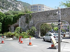
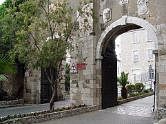
Flat Bastion and South Bastion (Spanish:Baluarte de Nuestra Señora del Rosario) were elements in the defence of the Africa Gate (Puerta de Africa),[5]now Southport Gates.[11][15]Southport Gate is the smallest of a trio of gates, west of Flat Bastion and adjacent to Trafalgar Cemetery, that are known as theSouthport Gates.[16][17]That smallest gate was the first of the three and was constructed by Italian engineerGiovanni Battista Calviat the same time that he designed the Charles V Wall, in 1552. The gate in the middle of the trio is ornamented with the arms ofQueen VictoriaandGovernor of GibraltarGeneral SirJohn Miller Adyeand was built in 1883. The third gate is the largest and was constructed in 1967. Entitled the Referendum Gate, it commemorates the votes cast byGibraltariansin theirsovereignty referendum of 1967.[9][18][19]Southport Gates are listed with the Gibraltar Heritage Trust.[7]
Prince Edward's Gateextends from the northwest corner of the bastion and overlooks Trafalgar Cemetery to the southwest and the formerSt. Jago's Cemeteryto the northwest.[4][11][20]It was constructed adjacent to the retired flank and behind theorillonof the bastion's west wall, which aided the gate's defence. The gate was named afterPrince Edward, Duke of Kent and Strathearn.At the time the gate was opened in the Charles V Wall, in 1790, the prince was serving with the military in Gibraltar.[4][19][20]Prince Edward's Gate is listed with the Gibraltar Heritage Trust.[7]
Flat Bastion Magazine
[edit]
The 1908Ordnance Surveymap of Gibraltar reveals Flat Bastion Magazine within the east side of the bastion. The British version of themagazinedates back to at least 1873, as documented on a keystone above one of the magazine's doorways(pictured right).It is considered likely that a magazine was present at that site previously.[4][21]The magazine was constructed onscreebreccia,with underlyinglimestonebedrock.[22]The road through the bastion is positioned just to the west of the magazine.[3]
The British magazine was constructed to store about five thousands barrels of gunpowder. The main area has been described as a "room within a room" as it is surrounded by a narrow hallway. Numerous wood supports are still present in the magazine.[4][23]The walls of the magazine were built with bricks to help absorb the impact of explosions. In addition, the oak doors of the magazine date back five or six centuries, well before the British version of the magazine.[23]
Flat Bastion Magazine had been abandoned for years when geology enthusiast Freddie Gomez undertook its restoration. Gomez, whose interests include both history and geology, converted the magazine to a geological research facility and exhibition centre. While much of the contents of the large collection of rocks and minerals are from his collection, other specimens have been donated.[4][6][23]The men of the150 (Yorkshire) Transport Regimentalso spent a day performing repairs at the magazine.[21]Gomez aspires to open the site to the public.[23]
The Gibraltar Heritage Trust has presented the Gibraltar Heritage Award annually since 1993. In 2001, the restoration of the Flat Bastion Magazine earned Gomez the 2001 award for "his enthusiasm and single-minded dedication to the restoration and preservation of Flat Bastion Magazine."[24][25]Flat Bastion Magazine is also listed with the Gibraltar Heritage Trust (in addition to the listing for the bastion itself).[7]
Gallery
[edit]-
 ThreeSouthport Gates
 -
 New and Old Southport Gates
 -
 Referendum Gate


References
[edit]- Notes
- Citations
- ^"List of Crown Dependencies & Overseas Territories".Foreign and Commonwealth Office.Retrieved25 September2012.
- ^Roach, John (13 September 2006)."Neandertals' Last Stand Was in Gibraltar, Study Suggests".National Geographic News.National Geographic Society.Archived fromthe originalon 14 November 2006.Retrieved25 September2012.
- ^abc"Map".Google Maps.Retrieved25 September2012.
- ^abcdefgh"Flat Bastion, Flat Bastion Magazine".DiscoverGibraltar.com (Click Fortifications, City Walls and Fortifications, Section 3, Flat Bastion). Archived fromthe originalon 5 September 2013.Retrieved25 September2012.
- ^abcdeFa, Darren;Finlayson, Clive(31 October 2006).The Fortifications of Gibraltar 1068-1945(illustrated ed.). Osprey Publishing. pp. 19–21, 56.ISBN9781846030161.Retrieved26 September2012.
- ^ab"Historical Gibraltar Attractions - Flat Bastion Magazine".Gibraltarinformation.com. Archived fromthe originalon 29 August 2012.Retrieved25 September2012.
- ^abcde"Gibraltar Heritage Trust - Gibraltar Heritage Trust Act 1989"(PDF).Government of Gibraltar.Archived fromthe original(PDF)on 27 August 2012.Retrieved25 September2012.
- ^"Reyes Pledges Commitment to Heritage".Gibraltar Chronicle.6 July 2010. Archived fromthe originalon 13 October 2013.Retrieved26 September2012.
- ^ab"The People of Gibraltar - 1740 - Skinner's Moorish Wall".Neville Chipulina.Retrieved26 September2012.
- ^Bethune, John Drinkwater (1786).A history of the late siege of Gibraltar(2 ed.). pp. 27–28.Retrieved27 September2012.
- ^abcd"Trafalgar Cemetery".Gibraltar Heritage Trust. Archived fromthe originalon 6 February 2007.Retrieved28 September2012.
- ^"View of the Town of Gibraltar".British Library.Retrieved28 September2012.
- ^"The New Look at Old Southport Ditch".Gibraltar Chronicle.11 October 2011. Archived fromthe originalon 14 October 2013.Retrieved26 September2012.
- ^Gilbard, Lieutenant Colonel George James (1881).A popular history of Gibraltar, its institutions, and its neighbourhood on both sides of the Straits, and a guide book to their principal places and objects of interest.Garrison Library Printing Establishment. p. 44.Retrieved27 September2012.
- ^"The People of Gibraltar".Neville Chipulina.Retrieved26 September2012.
- ^"Trafalgar Cemetery".DiscoverGibraltar.com. Archived fromthe originalon 13 October 2013.Retrieved26 September2012.
- ^Graham-Hart, John (6 June 2002)."Gibraltar: The Rock that's on a roll".The Telegraph.Retrieved26 September2012.
- ^Gilbard, Lieutenant Colonel George James (1881).A popular history of Gibraltar, its institutions, and its neighbourhood on both sides of the Straits, and a guide book to their principal places and objects of interest.Garrison Library Printing Establishment. p. 5.Retrieved27 September2012.
- ^ab"Historical Gibraltar Attractions (continued)".Gibraltarinformation.com. Archived fromthe originalon 26 February 2012.Retrieved25 September2012.
- ^ab"Gates & Fortifications".About Our Rock. Archived fromthe originalon 1 November 2012.Retrieved25 September2012.
- ^ab"Flat out at the Bastion".Gibraltar News from Panorama.Retrieved25 September2012.
- ^Gomez, Freddie (9 December 2007)."Applied Geology (Part 3) Urban Development".Vox - The Truly Independent Gibraltar Newspaper.Archived fromthe originalon 16 July 2012.Retrieved26 September2012.
- ^abcdNetto, David (28 March 2012)."New Geology Site at Renovated Flat Bastion Magazine".Gibraltar Chronicle.Archived fromthe originalon 10 March 2014.Retrieved25 September2012.
- ^"Gibraltar Heritage Awards 2012 Entry Form"(PDF).Gibraltar Heritage Trust. Archived fromthe original(PDF)on 10 March 2014.Retrieved25 September2012.
- ^"Running List of Heritage Award Winners"(PDF).Gibraltar Heritage Trust. Archived fromthe original(PDF)on 10 March 2014.Retrieved25 September2012.