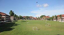
Fort Clayton
This article includes alist of references,related reading,orexternal links,but its sources remain unclear because it lacksinline citations.(March 2021) |


Fort Claytonwas aUnited States Armybase in the formerPanama Canal Zone,later part of the Republic ofPanama.
Base
[edit]Fort Clayton was located northwest ofBalboa, Panama,with thePanama Canallocated nearby. It closed in 1999 pursuant to theTorrijos-Carter Treaties.TheSouthern Command Networkand193rd Infantry Brigadewere both headquartered there, as was the headquarters ofUnited States Army Southprior to its relocation toFort Buchanan, Puerto Rico.The 534th Military Police Battalion stationed here was partly responsible for law enforcement patrols on all Pacific side military installations. This base also had significant on base housing for military families in addition to many barracks. Portions of the installation overlook theMiraflores Locksof thePanama Canal.
It is now used for residential housing, schools, and the headquarters of the "Ciudad del Saber"(City of Knowledge).
Education
[edit]TheDepartment of Defense Education Activity(DoDEA) formerly operated Fort Clayton Elementary School for children of American military dependents.[1]Curundu Elementary School was also in Fort Clayton.[2]The DoDEA secondary schools in Panama wereCurunduMiddle School andBalboa High School.[1]
See also
[edit]References
[edit]- ^ab"Americas.html".Department of Defense Education Activity. 1998-12-06. Archived fromthe originalon 1998-12-06.Retrieved2022-07-11.-Detail of Panama schools
- ^"Home Page".Curundu Elementary School. 1999-04-29. Archived fromthe originalon 1999-04-29.Retrieved2022-07-11.
https://ciudaddelsaber.org/en/what-is-city-of-knowledge/
