
Fort Jesus
You can helpexpand this article with text translated fromthe corresponding articlein French.(December 2015)Click [show] for important translation instructions.
|
| UNESCO World Heritage Site | |
|---|---|
 | |
| Location | Mombasa,Kenya |
| Criteria | Cultural: ii, v |
| Reference | 1295 |
| Inscription | 2011 (35thSession) |
| Area | 2.36 ha |
| Buffer zone | 31 ha |
| Coordinates | 4°03′46″S39°40′47″E/ 4.06278°S 39.67972°E |
 Location of Fort Jesus in Kenya | |

| History of Kenya |
|---|
 |
|
|
Fort Jesus(Portuguese:Forte Jesus de Mombaça, Spanish: Fuerte de Jesús) is afortlocated onMombasa Island.Designed by the Italian architectGiovanni Battista Cairati,[1]it was built between 1593 and 1596 by order ofKing Felipe II of Spain,who also reigned as King Filipe I of Portugal and the Algarves, to guard the Old Port ofMombasa.Fort Jesus is the only fort maintained by thePortugueseon theSwahili coastand is recognised as a testament to the first successful attempt by a Western power to establish influence over theIndian Ocean trade.[2]
Cairati, inspired by Italian architectPietro Cataneo,designed the fort, with the master builder being Gaspar Rodrigues. This was Cairato's last overseas work. Although the design of Fort Jesus is an example ofRenaissance architecture,the masonry techniques, building materials, and labor are believed to have been provided by the localSwahili people.The fort, built in the shape of a man viewed from the air, is roughly square with four bulwarks at its corners and is considered a masterpiece of lateRenaissancemilitary fortification.
Historical Significance
Fort Jesus was captured and recaptured at least nine times between 1631, when the Portuguese lost it to SultanYusuf ibn al-Hasanof Mombasa, and 1895, it fell underBritishrule and was converted into a prison. After the Portuguese recaptured it from the Sultan in 1632, they refurbished it and built more fortifications, subsequently making it harder for the fort to fall. The fort was subject toan epic two-year siegefrom 1696 to 1698 by theOmani Arabs,led bySaif bin Sultan.The capture of the fort marked the end of Portuguese presence on the coast, although they briefly captured and re-occupied it between 1728 and 1729 with the help of the Swahilicity-states.The fort fell under local rule from 1741 to 1837, when it was again captured by the Omanis and used as a barracks, before its occupation by the British in 1895, after the establishment of theEast Africa Protectorate(which later became, in 1920, theColony and Protectorate of Kenya).
Preservation and Legacy
In 1958, Fort Jesus was declared a national museum. In 2011, it was declared aWorld Heritage SitebyUNESCOand highlighted as one of the most outstanding and well-preserved examples of 16th-century Portuguese military fortifications.[2]The fort is Mombasa's most visited tourist attraction.
Overview
[edit]Between 1631 and 1875, the fort was won and lost nine times by the nations contesting control of Kenya. The Omanis took the fort in 1698 after anotable siegeof almost three years. It was declared a historical monument in 1958. Today it houses a museum.[3]
The fort was designed by aMilanesearchitect,Giovanni Battista Cairati,who was the Chief Architect for Portuguese possessions in the East. It was the first European-style fort constructed outside ofEuropedesigned to resistcannonfire.[4]Today, it is one of the finest examples of 16th-century Portuguese military architecture, which has been influenced and changed by both theOmaniArabs and the British.[5] The fort quickly became a vital possession for anyone with the intention of controllingMombasaIsland or the surrounding areas of trade. When the Britishcolonized Kenya,they used it as a prison, until 1958, when they converted it into a historicalmonument.James Kirkman was then assigned to excavate the monument, which he did (with a large use of external historical documents) from 1958 to 1971.[5]
The architecture of the fort represents the rough outline of a person lying on their back, with their head towards the sea. The height of the walls is 18 meters. The original Portuguese fort had a height of 15 meters, but the Oman Arabs added 3 meters upon capturing the fort.[6]
The fort combines Portuguese, Arab, and British elements (these being the major powers that held it at different times in history). The Portuguese and British presence is preserved in the presence of their respective cannons. The Portuguese cannons had a range of 200 meters and were longer than the British cannons, which had a range of 300 meters. Oman Arabs marked their occupancy with numerous inscriptions from the Koran on the wooden door posts and ceiling beams. TheMuslim tradition of five pillarsis also portrayed throughout the fort, with a former meeting hall supported by five stone pillars to the ceiling.
Some of the historical structures still standing in the fort include Oman House, which was the house of the sultan who governed the East African coast. Others are an open water cistern by the Portuguese for harvesting rainwater, and a 76-foot deep well sunk by the Arabs (but its water was too salty to be used for anything but washing).
The fort was declared a World Heritage site byUNESCOin 2011.[7][8]
Fort Jesus today
[edit]Today, Fort Jesus is a popular destination for foreign and local tourists and serves as a tourist destination, the fort is important as a host for numerous research programs, a Conservation Lab, an Education Department, and an Old Town Conservation Office.
-
 The outer wall
 -
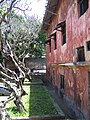
 Building inside the fort
 -
 Windows of the inner buildings
 -
 Juxtaposition of decayed and survived
 -
 Obvious influence of Portuguese architecture


References
[edit]- ^Parker, Geoffrey (18 April 1996).The Military Revolution: Military Innovation and the Rise of the West, 1500-1800.Cambridge University Press.ISBN9780521479585.Retrieved2 May2017.
- ^ab"Fort Jesus, Mombasa".UNESCO World Heritage Centre.Retrieved1 January2017.
- ^Mwakio, Philip."Mombasa's Fort Jesus could soon fall into the sea, warns agency".The Standard.Retrieved4 September2023.
- ^Gilbert, Erik, and Jonathan T. Reynolds.Africa in World History: From Prehistory to Present.New Jersey: Pearson Education, 2008, p. 225
- ^abKirkman, J. 1974.Fort Jesus: A Portuguese Fortress on the East African CoastClarendon Press: Oxford
- ^Onjoro, Veronica N."IN MY TOWN FORT JESUS MOMBASA".
{{cite journal}}:Cite journal requires|journal=(help) - ^"UNESCO World Heritage Sites in Kenya | TripLegend".17 May 2022.Retrieved4 September2023.
- ^The story of Fort Jesus - UNESCO & KTB,retrieved4 September2023
External links
[edit]4°3′45.85″S39°40′46.69″E/ 4.0627361°S 39.6796361°E
| International | |
|---|---|
| National | |
| People | |